Cookies.
This website uses cookies, which are small text files that the website puts on your device to facilitate operation. Cookies help us provide a better service to you. They are used to track general user traffic information and to help the website function properly.
Features
Nearby features appear when you click the map.
Declutter tracks on map.
Place Search
Video
X
Pub: by
Ox Mountains Area , N: Sligo Hills Subarea
Feature count in area: 18, by county: Sligo: 17, Mayo: 1, OSI/LPS Maps: 16, 24, 25, 31, 32, 33
Highest Place: Knockalongy 544m

Starting Places (13) in area Ox Mountains:
Belra, Glen Wood, Glenwood CP, Kingsmountain Wind Farm, Knockalongy, Largan Hill, Lough Achree, Lough Easkey, Masshill School, Queen Maeve's Grave, Rathcarrick Wood, Slishwood CP, Union Woods CP

Summits & other features in area Ox Mountains:
Cen: Annatoran: Annatoran 512m, Cloonacool 440m, Meenamaddo 330m, Sruffaungarve Top 400m
Cen: Talt: Knocknasliggaun 417m, Largan Hill 413m, Larganmore 276m
Cen: Tobercurry: Knocknashee 276m, Mucklety Hill 217m
N: Knockalongy: Cloonagh 349m, Knockalongy 544m, Knockalongy North-East Top 541m, Knockalongy South-West Top 521m
N: Sligo Hills: Doomore 272m, Killerry Mountain 293m, Knocknarea 327m, Slieve Daeane 275m, Slieveward 199m

Note: this list of places may include island features such as summits, but not islands as such.
Rating graphic.
Killerry Mountain, 293m Hill Sliabh Chill Oiridh A name in Irish,
Place Rating ..
(poss. Ir. ‡Sliabh Chill Oiridh [PDT], 'mountain of Cill Oiridh') Slish Mountain an extra name in English, Sligo County in Connacht province, in Binnion Lists, Killerry Mountain is the 1176th highest place in Ireland. Killerry Mountain is the most easterly summit and also the second most northerly in the Ox Mountains area.
Grid Reference G75109 31701, OS 1:50k mapsheet 25
Place visited by: 25 members, recently by: andalucia, Hyperstorm, Wilderness, david bourke, eamonoc, supersullivan, magnumpig, FrankMc1964, AdrianneB, conormcbandon, marymac, Hilldweller, harry66, Garmin, chalky
I visited this place: NO (You need to be a logged-in member for this.)
Longitude: -8.382474, Latitude: 54.233609, Easting: 175109, Northing: 331701, Prominence: 239m,  Isolation: 4.3km
ITM: 575064 831705
Bedrock type: Granoblastic kyanite pelite/ -semipelite, (Slishwood Division, Pelitic & semi-pelitic paragneiss)
Notes on name: Killerry, from Ir. Cill Oiridh [logainm.ie], is the name of a townland and a parish in the barony of Tirerrill. This peak is also known as Slish Mountain.
  Short or GPS IDs, 6 char: KlryMn, 10 char: KlryMntn

Linkback: https://mountainviews.ie/summit/960/
Gallery for Killerry Mountain (Sliabh Chill Oiridh) and surrounds
No summary yet for this place .
Member Comments for Killerry Mountain (Sliabh Chill Oiridh)
Comment create / edit display placeholder

            MountainViews.ie picture about Killerry Mountain (<em>Sliabh Chill Oiridh</em>)
Picture: Lough Gill and more !!!
Panoramic Hill Top.
by swoop 28 Jan 2011
Climbed 27th Jan 2011 with my buddy Zocolco.
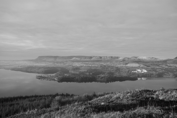
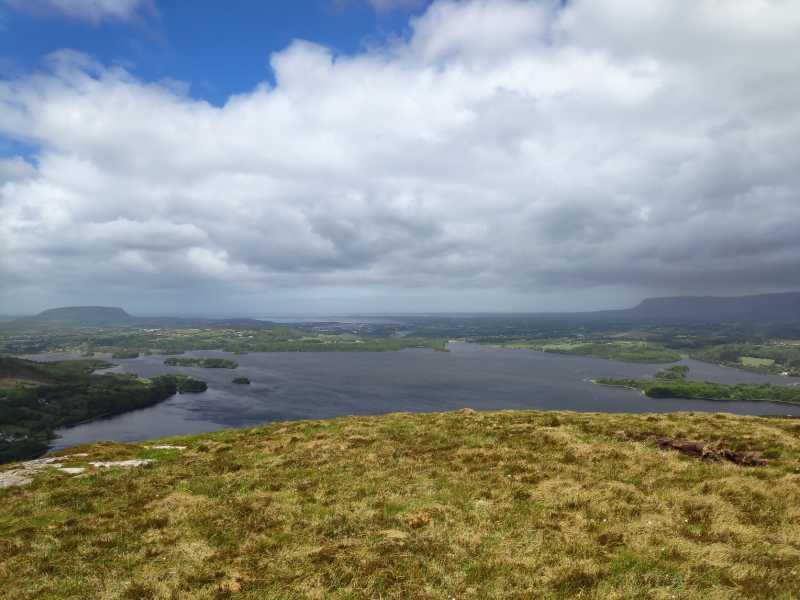
Amazing views from top looking north , you take in Benbulben , Kings , Copes, Truskmore,
( St.Angleas College- aka Eyesore) KBoy, Benbo and eve Dough in Leitrim. Looking west you see 90% of Lough Gill, Sligo Town Cathedral Spire , Knocknarea , even Ballyconnell head and Raghly in the distance.
Well worth the effort, but a bit off road when you get beyond upper forest level, the heather is knee high in places , and makes for slow progress. Also alot of bog holes , and sudden drops on the palteau, good light is required for safe trek. Approx 297m+ at summit. It was a relaxed
3 hr round trip, not difficult, just slow. Best panoramic view of Sligo I have seen. St Angelas college is the only eye sore , it should never have got planning , what a blatant mistake. Linkback: mountainviews.ie/summit/960/comment/6221/
Read Less
Read More

            MountainViews.ie picture about Killerry Mountain (<em>Sliabh Chill Oiridh</em>)
First peak in 2 months
by magnumpig 25 May 2020
Climbed Killerry on Saturday afternoon. Nothing for it but to park in Slish Wood and beat a track up through the scrub. Extensive views from the top of Knocknarea, Benbulben and the Dartrys at large. The Lake Isle of Innisfree is a nice little reward on the path back to the car. Linkback: mountainviews.ie/summit/960/comment/20790/
Read Less
Read More

Geo on Killerry Mountain
by Geo 29 May 2009
Climbed Friday 29th May 09. This is a hill with the heart of a mountain! From across Lough Gill you see it rise up from the gap created where Slish Wood lies. This is a good spot to start, but there's no obvious way up this one, you follow the forest track to the left out of the car park, then hang a right. We followed this for about a half hour and then as the track doubled back on itself to the left, we thought we were gone too far past the mountain and we would cut up the right hand side of the track and through the trees. A rough deer track helped us us a little, and we kept upwards emerging out of the trees quickly enough at A (G75189 32593). From here it was a matter of fighting our way slowly upwards in generally the right direction through boot leather tough heather. About an hour later we were on the top, marvelling at the views. This hill may be small, but you can see forever. North over the Dartry range and menacing Benbulbin, with Lough Gill in the foreground, inviting you to take a closer peek. Further east over Leitrim's hills, South to the Bricklieve's and West to the rest of the oxen! Beautiful, beautiful, and to think I'm the first to mark it climbed, and first to comment, Brilliant! Thank you Killerry, or Slish if you prefer, you gave me a morning's pleasure, 3 hours of filling my boots with heather seed and a slog down to find the car park again, but you are forgiven, for you are a darling mountain... Linkback: mountainviews.ie/summit/960/comment/3789/
Read Less
Read More

Killery
by Ryan_mournes 8 Apr 2012
Approached this with no definite route in mind, turned out to be the hard option, but well worth it! Cut through the forest straight from the car park and came out onto the mountainside within a couple of minutes. A slog over heather followed to the base of the western face. Came across some deer who made themselves scarce with alacrity. The ascent was very steep, the terrain being solely heather. took approx. 30mins from base then a sequence of false summits before the reward of the view over Gill and north to the Dartry mountains. Descended towards the lough on a flank, passing through a nice, spacious swampy area to emerge on the forest path where it cuts back on itself. Linkback: mountainviews.ie/summit/960/comment/6763/
Read Less
Read More
EDIT Point of Interest
text
Videos

Recent Contributions
x
Conditions and Info
Use of MountainViews is governed by conditions and a privacy policy.
Read general information about the site.
Opinions in material here are not necessarily endorsed by MountainViews.
Hillwalking is a risk sport. Information in comments, walks, shared GPS tracks or about starting places may not be accurate for example as regards safety or access permission. You are responsible for your safety and your permission to walk.
See the credits and list definitions.

OSi logo
OSNI/LPS logo
Open Street Map
(Various variations used.)
British summit data courtesy:
Database of British & Irish Hills