This website uses cookies, which are small text files that the website puts on your device to facilitate operation. Cookies help us provide a better service to you. They are used to track general user traffic information and to help the website function properly.
Feature count in area: 57, by county: Cork: 32, Kerry: 36, of which 11 are in both Cork and Kerry,
OSI/LPS Maps: 83, 84, 85, 88
Highest Place: Hungry Hill 682m
Starting Places (51) in area Caha Mountains: Ardgroom, Barley Lake North, Bere Island Pier, Caha Pass, Canshanavoe South, Carriganine, Cashelkeelty Stone Circles Carpark, Castletownbere Lifeboat Harbour, Clashduff River Farm, Coolieragh Harbour Road, Coomadayallig Lake Road N, Coomadayallig Lake Road S, Cooryeen Lane, Cummer Lough East Road, Derreenataggart Stone Circle Road, Dromoghty Lough North, Dunboy Wood, Esk Boreen, Eyeries, Fehanah Lane, Garinish Island Pier, Glantrasna Bridge, Glenbeg Lough N, Glengarriff, Glengarriff Nature Reserve CP, Gleninchaquin Waterfall, Gowlaun Lough, Healy Pass, Healy Pass Hairpin, Ilnacullin Car Park, Kenmare Bridge, Knockacullin Lane, Leahill Bog, Leitrim Beg Standing Stone, Lough Inchiquin SE, Magannagan Stream, Molly Gallivan's Visitor Centre, Nora's Cottage, Old Lansdowne School, Owgarriff River Lane, Peg's Shop, Pooleen Wood Car Park, Red Trout Lake, Reenroe Bridge, River Drimminboy Track, Rossmackowen Bridge, Rossmackowen Cemetery, Shronebirrane Farm, Shronebirrane Road, Toberbanaha, Turner's Rock Tunnel
Summits & other features in area Caha Mountains: Cen: Hungry Hill: Coombane 510m, Derryclancy 554m, Hungry Hill 682m Cen: Knockowen: Cushnaficulla 594m, Glenkeel Top 417m, Knockastumpa 398m, Knockeirky 577m, Knockeirky South Top 523m, Knockowen 658m, Stookeennalackareha 412m E: Glengarriff: Derrynafulla SW 375m, Gowlbeg Mountain 362m, Nareera 530m, Nareera North Top 503m, Nareera South-West Top 505m, Shrone Hill 283m, Sugarloaf Mountain 574m, Sugarloaf Mountain Far West Top 560m, Sugarloaf Mountain West Top 565m N: Coomnadiha: Baurearagh Mountain 489m, Caha Far SE Top 555m, Caha SE Top 585m, Coomnadiha 644m, Coomnalack Top 435m, Cummeenbaun 510m, Droppa 522m, Killane Mountain 537m, Killane Mountain South-West Top 533m, Knockagarrane 414m, Knockreagh 500m N: Knockeirka: Barraduff Mountain 400m, Killaha Mountain 400m, Knockeirka 426m N: Knocknagorraveela: Derrysallagh 410m, Feorus East 474m, Knocknagorraveela 507m, Knocknagorraveela NE Top 464m N: Lauragh: Knockanoughanish 386m, Knockatee 330m S: Castletownbere: Disert 205m, Knockanallig (Bear Island) 267m W: Ardgroom: Derryvour Hill 160m W: Eskatarriff: Coomacloghane 599m, Eskatarriff 600.5m, Eskatarriff East Top 532.7m, Knocknaveacal North Top 509.1m, Knocknaveacal South Top 507.2m, Lackabane 603m, Tooreenbaha 408.7m, Tooreennamna 524m, Tooth Mountain 592m W: Knocknagree: Knocknagree 586m, Knocknagree East Top 461m, Knocknagree SE Top 442m, Lackawee 572m, Maulin 621m, Maulin North Top 579m
Note: this list of places may include island features such as summits, but not
islands as such.
Derrynafulla SW, 375mHill
Place Rating ..
, Cork County in Munster province, in Binnion Lists, Derrynafulla SW is the 1008th highest place in Ireland.
Grid Reference V88800 54780,
OS 1:50k mapsheet 85 Place visited by: 19members, recently by: jackos, maoris, chelman7, eamonoc, liz50, Fergalh, bandre, finkey86, ciarraioch, melohara, thomas_g, skhg, chalky, scapania, noelvontrap
I visited this place: NO (You need to be a logged-in member for this.)
Longitude: -9.610369, Latitude: 51.734918, Easting: 88800, Northing: 54780,
Prominence: 150m, Isolation: 2km ITM: 488774 554846 Bedrock type: Purple & green sandstone & siltstone, (Caha Mountain Formation) Notes on name: This peak is unnamed on OS maps. It lies on the boundary of the townlands of Derrynafulla and Coomarkane. Any information on the correct name of this hill would be welcome. Having been unable to defend Dunboy Castle against the English cannons, it was from Derrynafulla (Ir. Doire na Fola, 'oak-grove of the blood') that Donal Cam O'Sullivan Beare regrouped his forces and followers on December 31st 1602 before their arduous and perilous march northwards to meet the O'Rourkes in Leitrim.
Short or GPS IDs, 6 char: DrynSW, 10 char: DrynflSW Linkback: https://mountainviews.ie/summit/872/
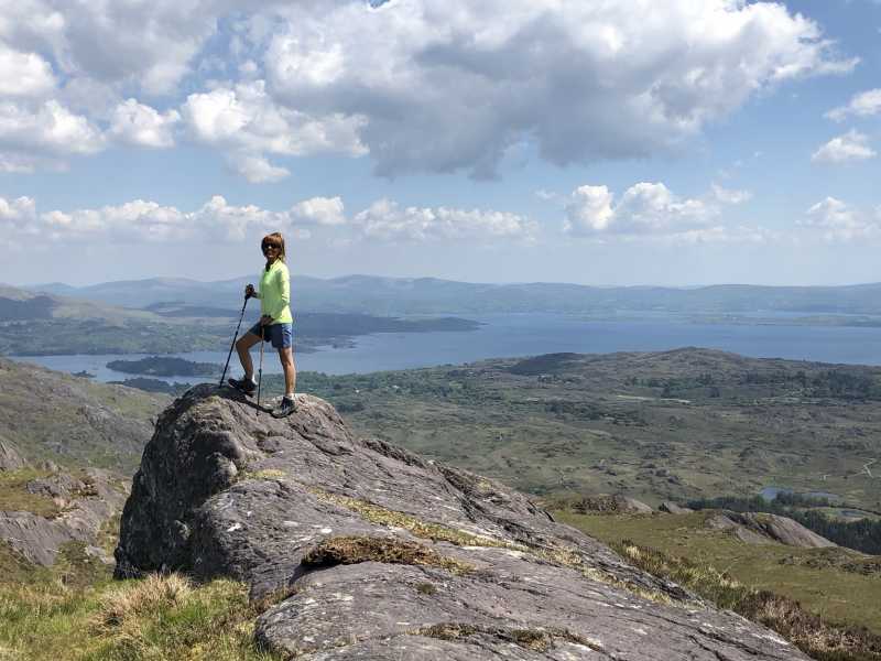
Picture: Glengarriff Harbour & Bantry Bay from Summit (with 'Mountain Fashion Policewoman' in Foreground)
West Cork's Finest!
by ciarraioch
12 Jun 2018
A certain pot-stirring Cork-domiciled Killorglin man has been held responsible for the saying 'West Cork, that part of Kerry that Kerry rejected!'
Well even if it were true, the Kingdom definitely came out the worst in this case!
Lovely, lovely little hill at the end of a charming valley. Glengarriff's fractal landscape throws up new surprises.
Park the car at layby after the bridge R'roe Br (V88770 55799). Follow Beara Way until approx A (V88357 54770) and then strike more or less directly for the summit.
Outstanding views west towards Sugarloaf and east over Glengarriff. We returned by the same route. Lovely café in Coomarkane, way off the beaten track, if you go left after the bridge on your return. Linkback: mountainviews.ie/summit/872/comment/19945/
Read Less
Read More
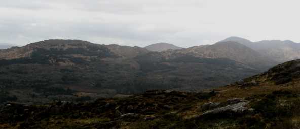
Picture: Sugarloaf Mountain and surrounding peaks seen from the Caha Mountain Pass
pdtempan on Derrynafulla SW
by pdtempan
22 Mar 2009
In this panorama the peaks in the distance are Sugarloaf Mountain (right) and Gowlbeg Mountain (centre). The hill in question is seen directly in front of Sugarloaf and Shrone Hill is to the left. Derrynafulla is the name of a townland at the foot of these last two peaks. Having been unable to defend Dunboy Castle against the English cannons, it was here that Donal Cam O'Sullivan Bere regrouped his forces and followers on December 31st 1602 before their arduous and perilous march northwards to meet the O'Rourkes in Leitrim. Linkback: mountainviews.ie/summit/872/comment/3665/
Read Less
Read More
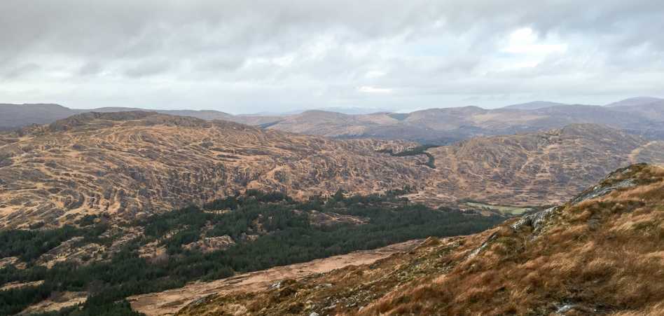
Picture: Derrynafulla (Left) and Shrone Hill (right) from Gowlbeg
Attempt from Derryconnery
by thomas_g
15 Dec 2014
I attempted to find a route up through the trees from Derryconnery, following the old Beara Way past where it turned to the south, I took the next right turn into a boggy valley by a stream. I attempted and failed to find a reasonable route through the trees on to Derrynafulla.
Next time, I'll either ignore this turning and walk to the end of the valley and climb onto the ridge where the Beara way now runs or approach from the Coomarkane valley to the north.
Moral of the story, don't go that way. Linkback: mountainviews.ie/summit/872/comment/17759/
Use of MountainViews is governed by conditions and a privacy policy.
Read general information about the site. Opinions in material here are not necessarily endorsed by MountainViews.
Hillwalking is a risk sport. Information in comments, walks, shared GPS tracks or about starting places may
not be accurate for example as regards safety or access permission. You are responsible for your safety and your permission to walk.
See the credits and list definitions.


 Our Facebook page.