This website uses cookies, which are small text files that the website puts on your device to facilitate operation. Cookies help us provide a better service to you. They are used to track general user traffic information and to help the website function properly.
Blackstairs MountainsArea, S: Blackstairs South
Subarea
Feature count in area: 13, by county: Wexford: 10, Carlow: 6, of which 3 are in both Carlow and Wexford,
OSI/LPS Maps: 68, EW-B, EW-B
Highest Place: Mount Leinster 794.4m
Starting Places (20) in area Blackstairs Mountains: Ballybawn Lane, Ballybeg Forest Road, Ballygibbon Lane, Ballyglisheen, Ballyvocran Cross, Bog Road L30072, Coonoge Cross Layby, Crooked Bridge, Glynn, Kilbrannish Forest Recreation CP, Mandoran Lane, R746 Half Way House, Raheenkyle, Rathanna Bridge, Sculloge Gap CP, Shannons Lane Sculloge, The Nine Stones CP, Urrin River Mid Rise, Urrin River Zig Zag, Urrin Road
Summits & other features in area Blackstairs Mountains: N: Blackstairs North: Black Rock Mountain 599.6m, Croaghaun 455.5m, Greenoge 425m, Knockmore 228m, Knockroe 538.8m, Mount Leinster 794.4m, Mount Leinster East Top 656.5m, Slievebawn 524.8m S: Blackstairs South: Blackstairs Mountain 732.1m, Carrigalachan 463m, Carrigroe 495m, White Mountain 509m, Slievebaun 441.8m
Note: this list of places may include island features such as summits, but not
islands as such.
Blackstairs Mountain, 732.1mMountain An Charraig Dhubh A name in Irish,
Place Rating ..
Ir. An Charraig Dhubh [logainm.ie], 'the black rock', Sturra, Stuadh Leithghlinn, Carlow/ Wexford County in Leinster province, in Arderin, Vandeleur-Lynam, Irish Highest Hundred Lists, Blackstairs Mountain is the second highest mountain in the Blackstairs Mountains area and the 88th highest in Ireland. Blackstairs Mountain is the second highest point in county Carlow and also the second highest in Wexford.
Grid Reference S81059 44833,
OS 1:50k mapsheet 68 Place visited by: 427members, recently by: Marykerry, rhw, Sophie-Hayes, MeabhTiernan, Tuigamala, maryblewitt, Dee68, davidrenshaw, Magic, Prem, Carolineswalsh, Nomad691, jellybean, MarionP, ToughSoles
I visited this place: NO (You need to be a logged-in member for this.)
Longitude: -6.805818, Latitude: 52.549212, Easting: 281059, Northing: 144833,
Prominence: 540m, Isolation: 1.9km ITM: 680990 644879 Bedrock type: Dark grey semi-pelitic, psammitic schist, (Ballybeg Member) Notes on name: Caher Roe's Den is a cave on the SW ridge of this peak. A jutting pinnacle at this place is called Sthurra [MacNeill, 225]. Caher Roe's Den is named after Cathaoir na gCapall of the O’Dempsey family from Laois. After he was dispossessed, he turned rapparee and stole horses. He was hanged at Maryborough (Port Laoise) in August 1735. The Den is reputed to hold his treasure. However, Máire MacNeill remarks: We doubt if Cathaoir na gCapall ever had to take refuge there. The cave-dwelling abductor, the owner of treasure in the bowels of the mountain, was not, we are sure, the eighteenth century raparee, but an ancient deity, possibly the remote divine ancestor of the Leinstermen, Cathair Már. Local people used to climb to Caher Roe's Den on Mountain Sunday, the last Sunday of July [MacNeill, 225-27].
Short or GPS IDs, 6 char: BlckMn, 10 char: BlckstMntn Linkback: https://mountainviews.ie/summit/85/
Gallery for Blackstairs Mountain (An Charraig Dhubh) and surrounds
Summary
for Blackstairs Mountain (An Charraig Dhubh):
Good access and a great viewpoint above a patchwork quilt of fields
Summary created by markmjcampion, Peter Walker, Onzy
2023-08-31 12:18:52
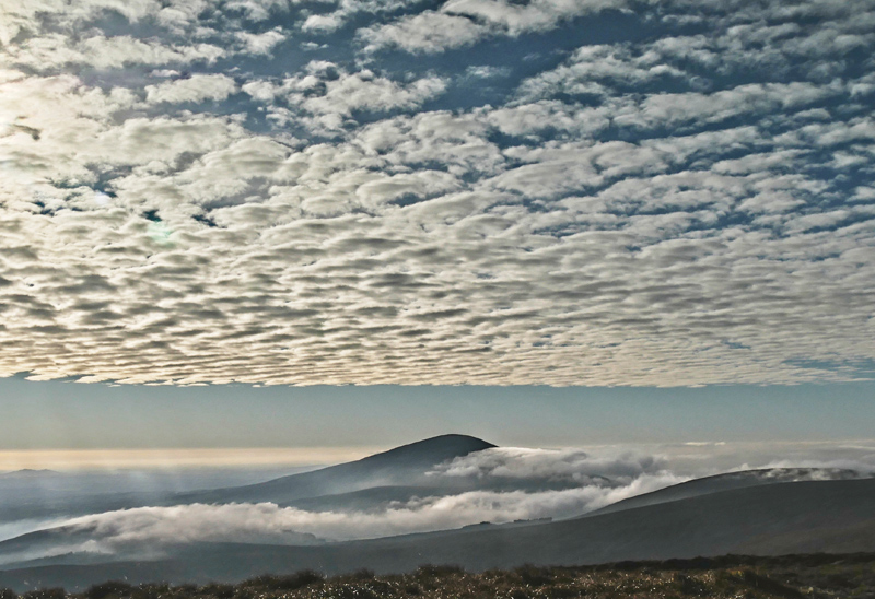
Picture: Blackstairs Mountain from Kiltealy to the NE
Just S of Mt. Leinster, Blackstairs Mt. is a prominent hill on the main ridge separating Carlow & Wexford. Views are good in all directions, mostly over flatlands, but dominated by the peak of Mt. Leinster to the N. Brandon Hill and Slievenamon are also visible. This is a hill-walker friendly region and there are a number of approaches.
N. Perhaps the most straight-forward ascent is from the Scullogue Gap, parking at Scull Gp (S81378 47884). There is a well-worn track from here which can be quite wet. 1.5 to 2 hrs.
S. Park near the start of a forest track at B'Bawn Ln (S80872 40979). Take the track up to the col NE of Carrigalachan and head N along the ridge from here. 2hrs
W. Start from A (S78700 43824), head up the zigzag track to the obvious col. Then it’s a fairly steep 2k ascent NW to B. En route you pass Caher Roe’s Den B (S80138 43838) - among the rocky outcrops is a cave said to hold the treasure of the O’Dempsey family of Laois. 1.5 hrs+
W. Park near B'Beg Fst Rd (S77806 42791) and take the forest rd to the NE. When you exit the forest head up the steep slopes to theh aforementioned col and head NW to B. 1.75 hrs
The entire ridge can be traversed by starting near BnLour Wd (S75817 35576), taking in Bran Scultair, Carrigroe and Carrigalachan, before reaching B itself, then dropping to the Scullogue Gap, with the option of extending to Mt. Leinster and exiting the ridge at the Nine Stones 9 Stones (S81643 54638) - entire traverse 8 hrs+
Notable tracks – the linear track/4119, circular track/4617 and track/3370
the more remarkable thing about blackstairs mountain is the view on top, mt leinster to the immediate north is the only other high point, and south,east and west directions are uninterrupted expanses of flat countryside
least thats how it appears so high above, looking down the west flank, the mountain drops quite steeply to a maze of patch work fields far below fanning out to the far horizon
blackstairs mountain is also known locally as white mountain and near the summit an old rusted iron cross marks the spot where a light aircraft crashed killing its pilot quite some years ago,
according to locals the story is true although nobody i asked could put a date on it
Picture: Blackstairs Mountain from Cahir Roe's Den
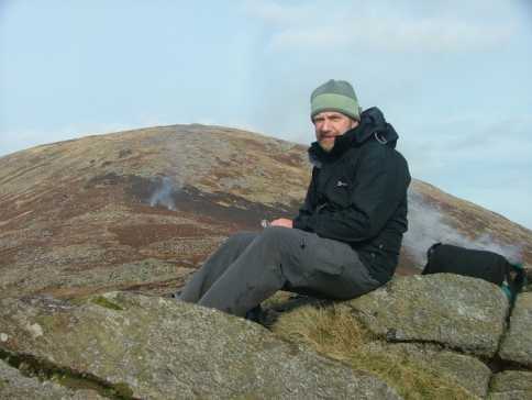
djouce on Blackstairs Mountain
by djouce
10 Apr 2009
A short pleasant hike up Blackstairs starts at a well-signposted trail not far from Sculloge Gap (see walk description) which leads over rough ground to the top of Blackstairs mountain. Follow the ridge towards Cahir Roe's Den, (fires - presumably to clear heather were burning) drop to the col and follow the green road to Knockmulgurry. The area is quite well-signed. Local people are welcoming to walkers as other writers have commented. Linkback: mountainviews.ie/summit/85/comment/3710/
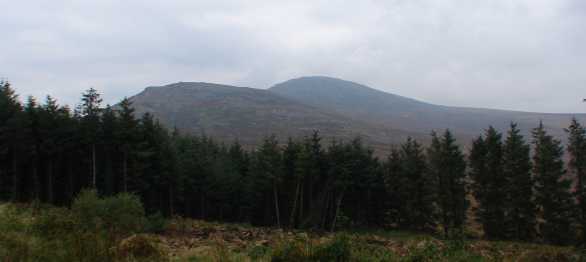
Picture: (L to R) Caher Roe's Den and Blackstairs Mountain viewed from the SE
csd on Blackstairs Mountain
by csd
7 Oct 2007
It's also possible to attack Blackstairs Mountain from the southeast. Park at the start of the forest track at B'Bawn Ln (S809 410) and follow it up to the saddle between Carrigalachan and Caher Roe's Den. Turn right and up you go: navigation is straightforward. Some damage from quad bikes is evident on the Den. The picture shows the view of Caher Roe's Den and Blackstairs Mountain from the forest track mentioned above. Linkback: mountainviews.ie/summit/85/comment/2858/
Read Less
Read More
Nature at its best
by Gobbledygook
16 Jun 2014
An absolutely fantastic area with breathtaking views. A patchwork of beautiful colours from nature. There are a few trails to follow which are easy to access and are well signposted. I will have to return to explore further. Linkback: mountainviews.ie/summit/85/comment/17506/
Use of MountainViews is governed by conditions and a privacy policy.
Read general information about the site. Opinions in material here are not necessarily endorsed by MountainViews.
Hillwalking is a risk sport. Information in comments, walks, shared GPS tracks or about starting places may
not be accurate for example as regards safety or access permission. You are responsible for your safety and your permission to walk.
See the credits and list definitions.


 Our Facebook page.