This website uses cookies, which are small text files that the website puts on your device to facilitate operation. Cookies help us provide a better service to you. They are used to track general user traffic information and to help the website function properly.
Feature count in area: 64, by county: Derry: 34, Tyrone: 39, of which 9 are in both Derry and Tyrone,
OSI/LPS Maps: 12, 13, 6, 7, 8
Highest Place: Sawel 678m
Starting Places (21) in area Sperrin Mountains: Altinure Road, Banagher Glen Nature Reserve, Barnes Gap Car Park, Crocknakin, Drumnaspar Picnic CP, Glenchiel Road, Glenedra Bridge, Glenelly Road, Parkreagh, Goles Road, Lough Ouske, Moneyneany Village, Moydamlaght Forest, Moydamlaght Road, Mullaghmore, Mullaghbane, Spaltindoagh, Sperrin Hamlet, Sperrin Heritage Centre, Sperrin Heritage Centre W, Sperrin Road, Barnes Top, Sperrin Road, Glashagh Bridge, Sperrin Road, Sperrin
Summits & other features in area Sperrin Mountains: E: Magherafelt Hills: Slieve Gallion NE Top 493.6m E: Magherafelt Hills: Slieve Gallion 526.6m N: Claudy Hills: Crockdooish 321m, Curradrolan Hill 270m, Eglish 277m, Letterlogher 249m, Mullaghmeash Hill 244m, Slieveboy 259m, Straid Hill 303m NE Cen: Glenelly North East: Barnes Top 456m, Craigagh Hill 460m, Crockbrack 526.1m, Knockanbane Mountain 441m, Meenard Mountain 620m, Meenard Mtn W Top 480m, Mullaghaneany 627m, Mullaghash 480m, Mullaghsallagh 485m, Oughtmore 569m, Spelhoagh 568m NE: Glenshane North: Benbradagh 465m, Boviel Top 454m, Carn Hill 448m, Carntogher 464m, Moneyoran Hill 414m NE: Glenshane South: Bohilbreaga 478m, Coolnasillagh Mountain 423m, Corick Mountain 430m, Crockalougha 407m, Mullaghmore 550m, White Mountain 537m NW Cen: Glenelly North West: Dart Mountain 619m, Dart Mountain North-West Top 525m, Learmount Mountain 489m, Learmount Mountain South Top 492m, Mullaghasturrakeen 581m, Mullaghcarbatagh 517m, Mullaghclogha 635m, Mullaghclogher 572m, Mullaghdoo 568m, Sawel 678m NW: Maheramason Hills: Clondermot Hill 220m, Gortmonly Hill 218m, Slievekirk 370m SE Cen: Glenelly South East: Carnanelly 562m, Carnanelly West Top 503.4m, Mullaghbane 467m, Mullaghturk 416m SE: Cookstown Hills: Cregganconroe 300m, Fir Mountain 362m, Oughtmore 382m SW Cen: Glenelly South West: Clogherny Top 408m, Craignamaddy 385m, Crocknamoghil 335m, Mullaghbolig 442m, Spaltindoagh 420m SW: Mullaghcarn: Curraghchosaly Mountain 416m, Mullaghcarn 542m, Mullaghcarn South Top 525m SW: Newtownstewart Hills: Bessy Bell 420m, Mullaghcroy 242m W: Strabane: Balix Hill 403m, Knockavoe 296m, Owenreagh Hill 400m
Note: this list of places may include island features such as summits, but not
islands as such.
Balix Hill, 403mHill
Place Rating ..
, Tyrone County in Ulster province, in Carn Lists, Balix Hill is the 930th highest place in Ireland.
Grid Reference H47555 96193,
OS 1:50k mapsheet 13 Place visited by: 32members, recently by: wintersmick, Claybird007, killyman1, trostanite, dregishjake, dregish, LorraineG60, MichaelG55, m0jla, eamonoc, eejaymm, scottwalker, Aidy, Ulsterpooka, sandman
I visited this place: NO (You need to be a logged-in member for this.)
Longitude: -7.261161, Latitude: 54.811308, Easting: 247555, Northing: 396193,
Prominence: 188m, Isolation: 4.5km ITM: 647493 896182 Bedrock type: Limestone, (Dungiven Formation) Notes on name: Balix is a townland name but is derived from (Ir. Béalóga, 'narrow gap(s)' [inferred from HDGP].
Short or GPS IDs, 6 char: BlxHl, 10 char: Balix Hill Linkback: https://mountainviews.ie/summit/816/
Gallery for Balix Hill and surrounds
Summary
for Balix Hill :
The skirting board of the Sperrins
Summary created by Peter Walker
2012-11-04 21:02:51
Balix Hill is one of the eminences forming the gradual north-westerly decline from the higher Sperrins, and its isolated-yet-integrated location provides fine vistas of the main range and a vast prospect over the lowlands to Derryveagh and Inishowen and Cuilcagh.
Start from the road junction at (A (H481 956)) from where a track heads NNE: it should be possible to get a car or two off the road at an opening just NW of here. The track plods purposefully and damply uphill over gates and the odd fence: at a fourth gate before it levels off into more open country turn left and follow a fence up to the summit area. The terrain is a typically Sperrinesque combo of tussocks and bog criss-crossed by fences that constitute the only real obstacles. A few upturned stones mark the top, although other surfaces nearby look similarly high.
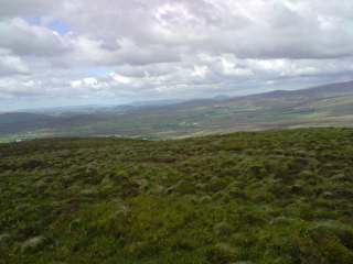
Talking Ballix! One of the Sperrins outliers accessed from a track opposite junction of Glencoppagh Road IB (H482 956). Alternatively there is another track a little further up the hill just beyond the trees which will also bring you on to the hill's SE slope. An unremarkable hill which will only take 35 minutes up and down again. Might not seem worth it except that in this case you get maximum scenery for minimal effort. Views across to the high Sperrins, over to Benbradagh E & NE are great together with expansive views southwards with Cuilcagh on the Cavan/Fermanagh border also clearly visible. but there are even more spectacular views NNW towards the Derryveagh Mts in Donegal. On the day it looked like you could throw a stone and hit Muckish and Errigal! Apologies for the pictures - walk was opportunistic so I had to use the phone camera. Linkback: mountainviews.ie/summit/816/comment/3815/
Read Less
Read More
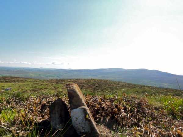
Picture: Summit stone marker
A load of b....xs!
by Colin Murphy
27 Jul 2011
Used eflanaga's route to top, which took approx 45 minutes up and down. Summit has recently been subject to gorse burning and resembles the location of a napalm attack. No particularly interesting features - one purely for the baggers methinks. Linkback: mountainviews.ie/summit/816/comment/6436/
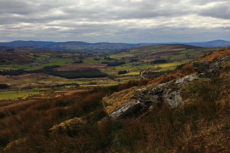
Picture: View over the countryside to the southwest
Pleasant Views For Minimum Effort
by Aidy
18 Mar 2016
Started from C (H48539 95495), parking in front of an abandoned farm house. Crossing a gate beside the house, it was just a case of bearing almost directly northwest up a grassy field, then over rougher, heather covered ground, to the summit. An easy walk, with the only difficulty being getting over a few awkward fences. Not the most dramatic of tops, but pleasant enough views around the Sperrins, and further afield, particularly towards the Derryveagh Mountains on the horizon. Definitely worth the minimum effort required. Linkback: mountainviews.ie/summit/816/comment/18461/
Use of MountainViews is governed by conditions and a privacy policy.
Read general information about the site. Opinions in material here are not necessarily endorsed by MountainViews.
Hillwalking is a risk sport. Information in comments, walks, shared GPS tracks or about starting places may
not be accurate for example as regards safety or access permission. You are responsible for your safety and your permission to walk.
See the credits and list definitions.


 Our Facebook page.