This website uses cookies, which are small text files that the website puts on your device to facilitate operation. Cookies help us provide a better service to you. They are used to track general user traffic information and to help the website function properly.
Sperrin MountainsArea, SW Cen: Glenelly South West
Subarea
Feature count in area: 64, by county: Derry: 34, Tyrone: 39, of which 9 are in both Derry and Tyrone,
OSI/LPS Maps: 12, 13, 6, 7, 8
Highest Place: Sawel 678m
Starting Places (21) in area Sperrin Mountains: Altinure Road, Banagher Glen Nature Reserve, Barnes Gap Car Park, Crocknakin, Drumnaspar Picnic CP, Glenchiel Road, Glenedra Bridge, Glenelly Road, Parkreagh, Goles Road, Lough Ouske, Moneyneany Village, Moydamlaght Forest, Moydamlaght Road, Mullaghmore, Mullaghbane, Spaltindoagh, Sperrin Hamlet, Sperrin Heritage Centre, Sperrin Heritage Centre W, Sperrin Road, Barnes Top, Sperrin Road, Glashagh Bridge, Sperrin Road, Sperrin
Summits & other features in area Sperrin Mountains: E: Magherafelt Hills: Slieve Gallion NE Top 493.6m E: Magherafelt Hills: Slieve Gallion 526.6m N: Claudy Hills: Crockdooish 321m, Curradrolan Hill 270m, Eglish 277m, Letterlogher 249m, Mullaghmeash Hill 244m, Slieveboy 259m, Straid Hill 303m NE Cen: Glenelly North East: Barnes Top 456m, Craigagh Hill 460m, Crockbrack 526.1m, Knockanbane Mountain 441m, Meenard Mountain 620m, Meenard Mtn W Top 480m, Mullaghaneany 627m, Mullaghash 480m, Mullaghsallagh 485m, Oughtmore 569m, Spelhoagh 568m NE: Glenshane North: Benbradagh 465m, Boviel Top 454m, Carn Hill 448m, Carntogher 464m, Moneyoran Hill 414m NE: Glenshane South: Bohilbreaga 478m, Coolnasillagh Mountain 423m, Corick Mountain 430m, Crockalougha 407m, Mullaghmore 550m, White Mountain 537m NW Cen: Glenelly North West: Dart Mountain 619m, Dart Mountain North-West Top 525m, Learmount Mountain 489m, Learmount Mountain South Top 492m, Mullaghasturrakeen 581m, Mullaghcarbatagh 517m, Mullaghclogha 635m, Mullaghclogher 572m, Mullaghdoo 568m, Sawel 678m NW: Maheramason Hills: Clondermot Hill 220m, Gortmonly Hill 218m, Slievekirk 370m SE Cen: Glenelly South East: Carnanelly 562m, Carnanelly West Top 503.4m, Mullaghbane 467m, Mullaghturk 416m SE: Cookstown Hills: Cregganconroe 300m, Fir Mountain 362m, Oughtmore 382m SW Cen: Glenelly South West: Clogherny Top 408m, Craignamaddy 385m, Crocknamoghil 335m, Mullaghbolig 442m, Spaltindoagh 420m SW: Mullaghcarn: Curraghchosaly Mountain 416m, Mullaghcarn 542m, Mullaghcarn South Top 525m SW: Newtownstewart Hills: Bessy Bell 420m, Mullaghcroy 242m W: Strabane: Balix Hill 403m, Knockavoe 296m, Owenreagh Hill 400m
Note: this list of places may include island features such as summits, but not
islands as such.
Clogherny Top, 408mHill Cnoc na Clocharnaí A name in Irish,
Place Rating ..
, Tyrone County in Ulster province, in Carn Lists, Clogherny Top is the 909th highest place in Ireland.
Grid Reference H58873 90833,
OS 1:50k mapsheet 13 Place visited by: 29members, recently by: Colin Murphy, Paddym99, garybuz, Kilcoobin, trostanite, dregish, eamonoc, muschi, Fergalh, MichaelG55, LorraineG60, madfrankie, Wilderness, sperrinlad, Aidy
I visited this place: NO (You need to be a logged-in member for this.)
Short or GPS IDs, 6 char: ClghTp, 10 char: ClghrnyTop Linkback: https://mountainviews.ie/summit/790/
Gallery for Clogherny Top (Cnoc na Clocharnaí) and surrounds
Summary
for Clogherny Top (Cnoc na Clocharnaí):
Access via trail from north.
Summary created by Colin Murphy
2024-01-30 10:45:46
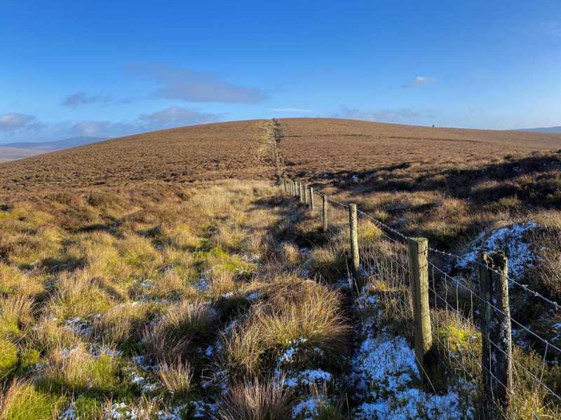
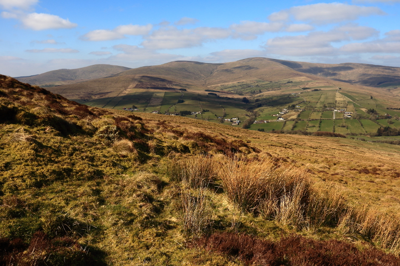
Picture: Clogherny from the SW.
This hill can be accessed fairly easily from the north, via a farm track leading to open hillside. There is parking for one car at A (H58210 91657). Follow track up for about 400m, where it bends to the west and continues as a grassy trail. Continue up this for another 200m to a gate. Cross gate and turn SE up through a field and then through another gate onto open hillside, where the ground underfoot is tussocy grass. Continue up towards a fence running roughly NW-SE towards Mullaghbolig, the terrain becoming rougher, more heather-covered above 350m elevation. Upon reaching the fence at B (H58404 90658), turn NE and follow it for 800m to high point, which is a simple elevated, unmarked heather mound.
The summit may also be accessed via Mullaghbolig, which requires a 2.5km walk along a broad ridge, following a frequently disappearing, narrow trail through heather.
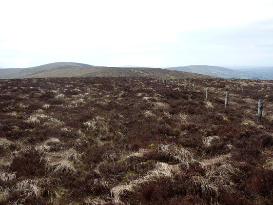
Picture: Looking W along ridge from Clogherney Top to Mullaghbolig
Harry Goodman on Clogherny Top
by Harry Goodman
26 Mar 2010
We climbed this hill on 19 March 2010 as part of a looped walk over the MV listed tops in the Central Sperrins. For the start of the walk see my comments on Mullaghbolig. Having arrived at the top of Mullaghbolig we decided to walk some 3k NE then E, over a couple of minor bumps, to the undistinguished summit of Clogherney Top. While we had fine views across the Glenelly Valley to the long W to E ridge of the High Sperrins and the walk was pleasant and not difficult the question you must ask yourself is do you really want to scale this uninteresting top, unless of course like me you wish to climb all of the MV listed tops in the Sperrins. This said, if the walk is included in a round of the other immediae hills (as we did) then you may find it a satisfying walk overall. Once there, rather than go back W along the ridge to the start we opted to head down NW across the hillside and then across a deep gulley and stream to pick up a rough stone and gravel track (not marked on the OS maps) about 1k from the top. This was at C (H58241 91350). From here it was a short walk down to the road (A (H58210 91657)). To complete our loop we turned left and, keeping left at any road junctions, had a 4.5k walk back to our starting point at D (H55173 89565). The high elevation of the road above the Glenelly valley made for a very scenic walk back. For anyone who simply wants to climb Clogherny Top, and I hasten to add I am not recommending it as a quality walk, the track up from the road where we exited (A (H58210 91657)) on a sharp corner beside a new looking stone bridge would make for a simple bag of this top. The full loop walk including Mullaghbolig was just over 10k . For anyone wishing to follow the full figure of eight looped walk, starting with Craignamaddy on the west side of Barnes Gap, the walking distance is approximately 18k (see also my comments on Craignamaddy) Linkback: mountainviews.ie/summit/790/comment/4538/
Read Less
Read More
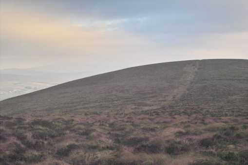
Picture: Clogherny Top from Tarnoge col
eflanaga on Clogherny Top
by eflanaga
24 Dec 2007
Climbed as part of a Central Sperrins ridge walk which started at Barnes Gap carpark IBarnsGp (H55121 90470), taking in Mullaghbolig and Tornoge before Clogherny Top itself. Clogherny's summit is like many in the Sperrins, heather covered, flat and featureless. The actual top is difficult to discern but appears to be a few metres from the fence which runs from Mullaghbolig to the eastern end of Corratary Hill near the end of the walk a distance of some 11K. Actual walk length from Barnes to Tourist Information IE (H64272 93712) north-east of Corratary Hill was 12K Underfoot conditions on section from Mullaghbolig to Cloghrny Top and beyond to Quiggy Hill were very good with sheep tracks close to fence providing easy walking conditions. The Central Sperrins don't offer a great deal of variety in themselves with each hill apparently glacially carved out as a rough image of its predecessor however, they do provide excellent views north across to where the High Sperrins with the 'Mullaghs', Dart & Sawel form a picturesque background, while to the right the lower lying and oft forested hills and ridges of the Sperrins roll gently southwards. Linkback: mountainviews.ie/summit/790/comment/2923/
Read Less
Read More
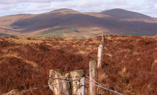
Picture: looking N to Dart & Sawel
gerrym on Clogherny Top
by gerrym
20 Mar 2008
If you have a look at the comment for Mullaghbolig you will find the information to get a good part of the way to this top. The crest of this line of hills roll like an elderly couple out for a Sunday drive so nothing too stressful. The ever present fence means the compass and map can stay safely tucked away. It may seem from this that the walk is not worth doing but nothing could be further from the truth. A light skiff of rain passed and the sky took on a sharper focus to the NW giving me a view of Errigal that was so sharp i literally held my hand out to touch it, the flat top of Muckish was clear as a Bessy Bell and the Aglhas in between. I still had all the Mournes and the Cooley mtns away to the SE. The variable light was adding to the different shades of vegeatation from valley to hilltop and overwhelming my optics with colour. It just felt great to be out on the hills with so much to see! The top is a short and gentle climb with views down over the hamlet of Cranagh in the Glenelly valley. I was just able to still see Errigal with most of the Bluestacks in view including the deep gap of Struell. I just turned around a couple of times and there was something to see with every degree of movement. There is a walk as long again to the high road crossing the hills through Glenlark forest. I was asking myself the question but i think the views had me by the short and curlies and i tramped on. I met a farmer on a quad and passed a few moments talking about the weather (what else!) and sheep (what else!) - he was gathering the sheep up for lambing. It took me 3 hours to reach the road following the fence all the way on pretty fair ground. If you like the sound of this one have a look at Spaltindoagh to square the circle so to speak. Linkback: mountainviews.ie/summit/790/comment/3006/
Read Less
Read More
Picture: On the slopes of Clogherny Top and Tonoge
Glenelly Valley Views
by Aidy
25 Mar 2016
Climbed in sunny weather on Sunday, starting at F (H57639 91375) near a road side phone mast where there was room to park without blocking the gate. I went just east of due south up to the top of Tornoge Hill first, then walked alongside the fence over to Clogherny Top. Great views the whole way along the Glenelly Valley on a short walk. Easy apart from some thick grass and heather in places, and some awkward fences. Linkback: mountainviews.ie/summit/790/comment/18471/
Use of MountainViews is governed by conditions and a privacy policy.
Read general information about the site. Opinions in material here are not necessarily endorsed by MountainViews.
Hillwalking is a risk sport. Information in comments, walks, shared GPS tracks or about starting places may
not be accurate for example as regards safety or access permission. You are responsible for your safety and your permission to walk.
See the credits and list definitions.


 Our Facebook page.