This website uses cookies, which are small text files that the website puts on your device to facilitate operation. Cookies help us provide a better service to you. They are used to track general user traffic information and to help the website function properly.
Feature count in area: 15, all in Kerry,
OSI/LPS Maps: 70, EW-DC, EW-DW
Highest Place: Brandon 951.7m
Starting Places (18) in area Brandon Group: Ballinloghig, Ballybrack Mid, Brandon Pilgrimage Trail, Brandon Point, Brandon Village, Cloghane Community Centre, Conor Pass, Coosavuddig Quay Brandon Creek, Faha, Feoghanagh River, Hostel Cloghane Village, Lough Camclaun, Lough Doon CP, Mullaghveal Farm, Pedlars Lodge, Pilgrimage Trail Owenmore River, Sauce Creek Walkway Dingle Way, Tiduff
Summits & other features in area Brandon Group: Cen: Faha Ridge: Benagh 822.5m, Faha Ridge 809.2m N: Brandon Point: Faill an tSáis 430.7m N: Brandon Ridge North: Brandon Far North Top 840.1m, Brandon North Top 895.4m, Masatiompan 761.9m, Pierasmore North Top 700m, Pierasmore 745.7m S: Ballysitteragh: An Bhinn Dubh 479.2m, Ballysitteragh 623m, Beennabrack 608.5m S: Brandon Ridge South: Gearhane 803m, Brandon Peak 840m, Brandon 951.7m, Brandon South Top 790m
Note: this list of places may include island features such as summits, but not
islands as such.
Pierasmore, 745.7mMountain Piaras Mór A name in Irish,
Place Rating ..
(Ir. Piaras Mór [OSI], 'big [obscure element]'), Kerry County in Munster province, in Arderin, Vandeleur-Lynam Lists, Piaras Mór is the 81st highest place in Ireland.
Grid Reference Q46380 13650,
OS 1:50k mapsheet 70 Place visited by: 224members, recently by: rhw, markwallace, maoris, Carolineswalsh, ToughSoles, Jai-mckinney, Carolyn105, Beti13, CusackMargaret, farmerjoe, chelman7, NualaB, Krzysztof_K, johncusack, Alanjm
I visited this place: NO (You need to be a logged-in member for this.)
Longitude: -10.250332, Latitude: 52.253569, Easting: 46380, Northing: 113650,
Prominence: 32.8m, Isolation: 0.2km ITM: 446363 613703 Bedrock type: Rhythmically bedded sandstone, (Ballymore Sandstone Formation) Notes on name: This name is interpreted as 'big Pierce' in the Ordnance Survey Name Book. However, An Seabhac reports that in his time, nearly a century later, nobody in the locality had an explanation for the name but they did not think it was related to the personal name Piaras. There is a lower peak to the N called Piaras Beag. On the saddle between Piaras Mór and Masatiompan is an ogham stone bearing an inscription which translates as: Ronan, the priest son of Camogann. There is a chi-ro monogram (representing 'Christ') above it and a Greek cross in a circle on the other side (Barrington, Discovering Kerry, 180).
Short or GPS IDs, 6 char: Prsmr, 10 char: Pierasmore Linkback: https://mountainviews.ie/summit/77/
Gallery for Pierasmore (Piaras Mór) and surrounds
Summary
for Pierasmore (Piaras Mór):
Stumpy Outcrop to Brandon's north
Summary created by Onzy
2014-03-09 19:11:13
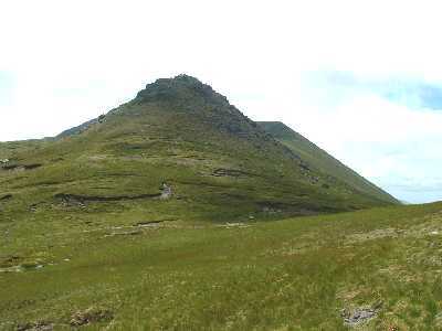
Pierasmore is an unusual outcrop at the northern end of the main Brandon ridge.
The summit is most easily reached from the Dingle Way which passes north of it at its col with Masatiompan. Suitable starting points using this route would be either Tiduff (Q43424 12610) (from the west and where there is a large carpark) or Sauce Ck (Q50825 14586) (from the east) In either case, following the Dingle Way will take one easily to the col, from which the summit is 500m south. The summit is normally combined with a traverse of the Brandon ridge, typically taking in from Masatiompan to Brandon itself, but easily extended south to Brandon Peak and Gearhane; or if a long day is planned, right to the Conor Pass. Using the Dingle Way, the ascent should take under two hours.
Views on a good day are spectacular in all directions, although Masatiompan does dominate to the north. There is a ogham stone on the col between Pierasmore and Masatiompan, whose inscription translates as ‘Ronan, the priest son of Comgall’.
Currently gps tracks 1848 and 2089 take in Pierasmore.
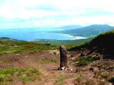
Photo taken from Pierasmore summit July 2002. Smerwick Harbour in the distance with Tearaght and the Blasket Islands visible. Linkback: mountainviews.ie/summit/77/comment/241/
Read Less
Read More
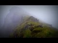
Picture: On Piaras Mor
View to Masatiopan
by three5four0
30 Aug 2011
Shorts and a t-shirt in April! A fine day we had for out traverse of the northern tops in the Brandon Group. Not many days like this in Dingle per year. I once spent 14 days straight waiting for a break in the weather to climb Brandon, and all i got was 14 days of rain, mist and gales! Linkback: mountainviews.ie/summit/77/comment/6501/
Read Less
Read More
GWPR on Pierasmore
by GWPR
5 Feb 2003
kaka (2003-01-28 12:04:38): mentions the ogham stone on the shoulder between Pierasmore and Masatiompan. Here is a photo I took of it, July 2002, looking towards the broad sweep of Brandon Bay and the Magharees. The inscription in Ogham translates,"Ronan, the priest son of
Comgall". These Ogham stones generally give the name of an individual, his father's name and some examples in West Kerry carry the name 'Duibhne' (Dovinias), a Goddess of the Corca Dhuibhne. THe view from here is stunning on a clear day! Ronan obviously had a love for the Mountains!
Source: Cloghane and Brandon, Walking Guide. Linkback: mountainviews.ie/summit/77/comment/319/
Use of MountainViews is governed by conditions and a privacy policy.
Read general information about the site. Opinions in material here are not necessarily endorsed by MountainViews.
Hillwalking is a risk sport. Information in comments, walks, shared GPS tracks or about starting places may
not be accurate for example as regards safety or access permission. You are responsible for your safety and your permission to walk.
See the credits and list definitions.


 Our Facebook page.