This website uses cookies, which are small text files that the website puts on your device to facilitate operation. Cookies help us provide a better service to you. They are used to track general user traffic information and to help the website function properly.
Feature count in area: 45, all in Donegal,
OSI/LPS Maps: 11, 6
Highest Place: Croaghgorm 674m
Starting Places (22) in area Bluestack Mountains: An Leathchruach, Barnsmore Gap, Bensons Hill, Caldragh CP, Clogher South peak, Cruach Mhín an Neanta, Doobin, Eanybeg Water Bridge, Edergole Farm, Gaugin Mountain, Glennacree CP, Hillhead, Lough Finn West, Lough Magrath Beg NE, Lough Muck North, Meenaguse Lough, Sand Lough Forest Picnic Area, Scoil Náisúnta an Choimín, Sheskinlubanagh, Sruell Gap Farm, Sruell River Road, St Columbkilles Well and Altar
Summits & other features in area Bluestack Mountains: Cen: Reelan Hills: Altnapaste 364m, Gaugin Mountain 565m, Lacroagh 403m, Boultypatrick 429m, Croveenananta 476m, Croaghubbrid 416m, Croaghugagh 410m N: Fintown Hills: Aghla Mountain South Top 589m, Aghla Mountain 593m, Scraigs 426m, Croaghleheen 385m NW: Glenties: Cloghercor South 301m, Derkbeg Hill 332m, Drumnalough Hill 282m S: Belshade: Croaghgorm 674m, Croaghgorm South-West Top 597m, Croaghgorm East Top 594m, Ardnageer 642m, Ardnageer SW Top 626m, Banagher Hill 392m, Croaghbane 641m, Croaghgorm Far South-West Top 561m, Cronamuck 444m, Croaghbarnes 498.8m, Glascarns Hill 578.3m, Meenanea 435m SE: Barnesmore: Brown's Hill 496.4m, Cloghervaddy 402m, Croaghagranagh 440m, Croaghanirwore 546.1m, Croaghbrack 401m, Croaghconnellagh 523m, Croaghnageer 569.1m, Croaghnageer East Top 543.5m, Croaghnageer North-East Top 521m, Croaghonagh 451m SW: Eany Beg Hills: Binbane 453m, Binbane NE Top 439m, Lavagh Beg 650m, Lavagh More 671m, Binnasruell 505m, Carnaween 521m, Cloghmeen Hill 429m, Silver Hill 600m, Cullaghacro 476m
Note: this list of places may include island features such as summits, but not
islands as such.
Boultypatrick, 429mHill Buailte Pádraig A name in Irish,
Place Rating ..
(Ir. Buailte Pádraig [OSI], 'Patrick's dairying places'), Donegal County in Ulster province, in Carn Lists, Buailte Pádraig is the 808th highest place in Ireland.
Grid Reference G96782 98038,
OS 1:50k mapsheet 11 Place visited by: 12members, recently by: Colin Murphy, Wilderness, eamonoc, Ulsterpooka, madfrankie, Fergalh, Aidy, chalky, Garmin, juliewoods, Jamessheerin, simon3
I visited this place: NO (You need to be a logged-in member for this.)
Short or GPS IDs, 6 char: Bltypt, 10 char: Bltyptrck Linkback: https://mountainviews.ie/summit/692/
Gallery for Boultypatrick (Buailte Pádraig) and surrounds
Summary
for Boultypatrick (Buailte Pádraig):
Unremarkable hill with challenging access issues.
Summary created by Colin Murphy
2023-07-13 15:48:16
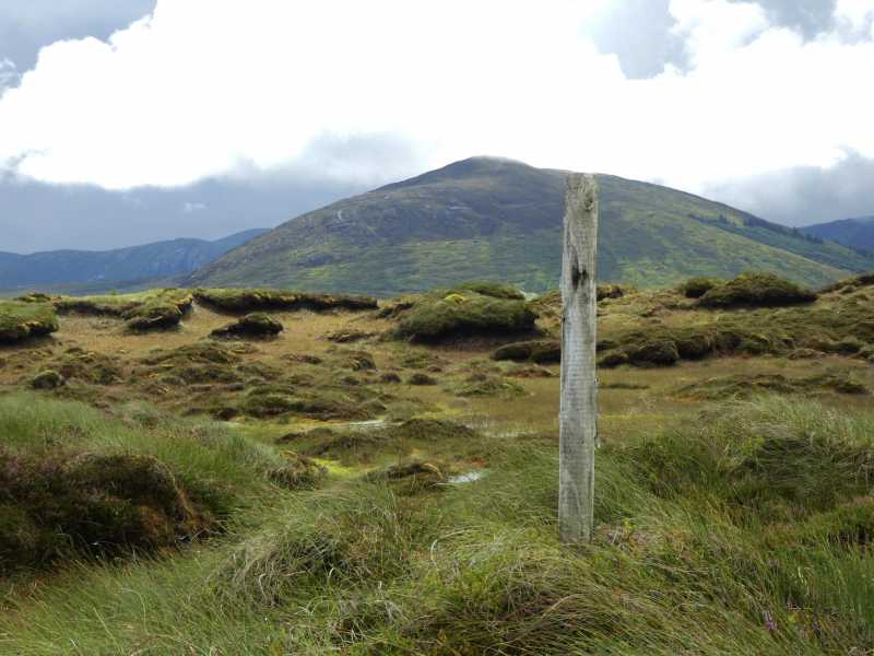
Picture: Summit marker with Gaugin Mt in distance.
This is a difficult summit to access from the south, but it can be done if you’re willing to persevere. There is parking for 1 or 2 cars at a forest entrance at Hillhead (G97359 96554). Cross the gate and proceed up the track to A (G97529 96949) and turn sharply left. Continue along this for about 1.5km to B (G96548 97219). Whereas satellite images appear to show a track continuing from here, much recent growth has made this difficult to locate. You can find forest breaks if you look, but it requires much pushing through low branches and it will require some perseverance to finally emerge onto the open hillside. Once free from the dense woods, the highpoint is a simple 200m gentle climb over heather. It is marked by a single wooden pole in a heathery mound.
And alternative, although also very challenging, is to start at Hillhead (G97359 96554) and walk 500m east along road to C (G97990 96711). Cross a gate into a small grassy field, go over a fence and ascend up along the forest edge. Unfortunately this is through 1km of waist high reeds with the ground underneath quite marshy even in summer. Eventually the reeds are replaced with grass. Turn west at forest corner and then strike out towards the highpoint.
Picture: Boultypatrick from Gaugin. Note the irregular forestry.
Rough summit with a confusing final approach. Interesting views.
by simon3
11 Aug 2012
Boultypatrick is a name which must one be of the top tragi-comic manglicisations of the earlier Ordnance Survey. It's an east-west ridge of approximately 5km long above 300m. The south side is heavily wooded in an irregular and confusing pattern of trees, felling and new growth. The north side has much less forestry on it.
Views from the top include the shapely quartzite of Gaugin and the classic north Donegal ridges such as Errigal to Muckish.
When I climbed it in 2012 no other member had logged climbing it and there were no comments either. I started at the forest entrance at Hillhead (G97359 96554) and used tracks as shown on the OS 1:10k layer used on this website which were mostly accurate, though with errors of omission. My plan was to get as high as possible on the marked tracks (around 300m) then strike for the summit. However there was a complicated maze of felled and replanted areas where that map said it should be clear. So I left the track at around D (G96203 97268) and headed for a small spur hoping that would take me out of the trees (Sitka spruce some 2 to 3m high in 2012) Eventually I got to the ridgeline. This was peat hags interspersed with sphagnum moss filled pools. The summit area is extremely indistinct and there is, of course, no cairn or any sign whatever of visitors. The top probably has less visitors in a decade than Carrauntoohil gets in day.
On the way down I experimented with the east side of the forest going straight down. While there was no track around the forest this had the merit that you could see what you were doing. However the ground is also extremely rough with rushes and underlying channels in peat. Passable going down but not recommended for going up.
The next MV visitors are advised to a. check the air photos for routes from the south or b. check for routes from the north. See Track 1983. Linkback: mountainviews.ie/summit/692/comment/14753/
Use of MountainViews is governed by conditions and a privacy policy.
Read general information about the site. Opinions in material here are not necessarily endorsed by MountainViews.
Hillwalking is a risk sport. Information in comments, walks, shared GPS tracks or about starting places may
not be accurate for example as regards safety or access permission. You are responsible for your safety and your permission to walk.
See the credits and list definitions.


 Our Facebook page.