Cookies.
This website uses cookies, which are small text files that the website puts on your device to facilitate operation. Cookies help us provide a better service to you. They are used to track general user traffic information and to help the website function properly.
Features
Nearby features appear when you click the map.
Declutter tracks on map.
Place Search
Video
X
Pub: by
Wicklow Area , S: Tinahely Hills Subarea
Feature count in area: 115, by county: Wicklow: 108, Kildare: 4, Wexford: 2, Carlow: 3, of which 1 is in both Wexford and Wicklow, of which 1 is in both Carlow and Wicklow, OSI/LPS Maps: 28B, 55, 56, 61, 62, AWW, EW-DM, EW-LG, EW-WE, EW-WS
Highest Place: Lugnaquilla 924.7m

Starting Places (205) in area Wicklow:
1916 Memorial Car Park, Aghavannagh Ow Bridge, Aghowle Wood, Altidore Wood Entrance, Annacurra National School, Annalecka Bridge, Asbawn Brook L8350, Aughrim National School, Ballard Road, Ballinabarny Gap, Ballinagappoge Bridge Layby, Ballinagappoge Mountain Hairpin, Ballinagore, Ballinahinch Wood, Ballinastoe MBT CP, Ballinastraw South, Ballineddan Upr Fork, Ballinfoyle Upr Cross, Ballycoog, Ballycreen Brook Bridge, Ballycumber, Ballycumber Bridge, Ballycumber Lane, Ballycumber Wicklow Way, Ballylerane, Ballylow Bridge, Ballylusk Quarry, Ballymanus Lane, Ballymoyle Shooting Lodge, Ballynultagh Gap, Ballynultagh Lane, Ballyreagh Wood, Ballyross Forest, Ballysmuttan Long Stone, Baravore, Barnbawn South, Barranisky North, Barranisky West, Bohilla Land Roundabout, Bohilla Lane Mid, Boranaraltry Bridge, Bray Harbour, Brewel West, Brittas Bay North CP, Buckroney Sand Dunes CP, Bus Terminus, Camera Hill Track Cross, Castletimon Wood North, Clara Vale, Clone House Road, Clonegal, Cloon Wood Cp, Coate Bridge, Coolballintaggart Ledge, Coolbawn House Lane, Cransillagh Brook , Crone Wood CP, Crossbridge, Crossoona Rath, Cummer Wood South, Curtlestown Wood CP, Deputy's Pass CP, Derralossary Church, Derry River Bridge, Devil's Glen CP, Devil's Glen Wood, Djouce Wood Calary, Djouce Wood Lake, Djouce Wood Long Hill, Donard, Donnelly's Lane Car Sales, Drumgoff Forest, Dunranhill North, Dunranhill SE, Dunranhill South, Dwyer McAllister Cottage CP, Enniskerry, Fentons Pub, Fitzsimons Park GAA, unuseableFlemings Footbridge Glen Rd, Gap Pub, Gap Road, Glen Beach CP, Glen of the Downs CP, Glenbride Lane, Glenbride Lodge, Glencree Reconciliation, Glendalough, Glenealy GAA, Glenmacnass Tonelagee CP, Glenmalure Hostel, Glenmalure Lodge, Glenmalure Waterfall, Glenview Hotel, Gowle House, Great Sugar Loaf CP, Grove Bar, Heffernans Well Wood, Hill View, Hollywood Glen, JB Malone CP, Johnnie Fox Pub, Keadeen NE trail, Keadeen Trailhead, Kevins Way Footbridge, Kilbride Army Camp Entrance, Kilcandra South, Kilcommon View, Killalongford Wood, Kilmacrea Cross Roads, Kilranelagh House Gate, Kilruddery Car Park, Kilruddery Cottages, Kings River, Kippure Bridge, Kippure Estate, Kippure Transmitter Gate, Knickeen Cross, Knocknaboley Lane Leeraghs Bog, Knocknaboley Lane Stone Cottage, Knockrath Little, Knockree west, Kyle Loop North, Lackan Wood S, Lake Dr Fraughan Brook, Lake Drive, Lake Park Cross, Lake View Pub, Laragh Free Car Park, Laragh NSch, Lead Mines CP, Liffey Bridge, Liffey Head Bridge, Lough Bray Lower, Lough Bray Upper, Lough Tay North Viewing Point, Lough Tay Wicklow Way CP, Luglass Lane L97561, Lugnagun Track, Macreddin Village, Mangans Lane, Military Road Carrigshouk Hill, Military Road Inchavore River Nth, Military Road Inchavore River Sth, Military Road NW Lough Tay, Military Road Ballyboy Bridge, Military Road Cloghoge Brook, Military Road Croaghanmoira, Military Road Fananierin, Military Road LaraghWicklow Way, Military Road Slieve Maan, Monspolien Bridge, Moortown House, Mountain Rescue HQ, Muskeagh Little Wood, Nahanagan Lough NE, Novara Avenue, Bray, Oiltiagh Brook Knickeen, Old Bridge Cross, Old Bridge Scouts , Old Wicklow Way entrance, Paddock Hill SE, Pier Gates CP, Powerscourt Waterfall CP, Putland Road, Quintagh East, Raheen Park CP, Raheenleagh East, Railway Walk CP, Rathdrum Railway Station, Rednagh Wood, Rocky Valley, Roundwood, Sally Gap, Sally Gap N, Seefin Trailhead, Seskin SE, Shankill Tributary Bridge, Shay Elliott, Sheepshanks Bridge, Shillelagh, Slievecorragh Track, Slievefoore South, Sraghoe Brook, St John's Church, St Kevins Chair, St Kevins Church, St Kevins Way R756, Stone Circle Bridge, Stookeen South, Stranahely Wood, Stranakelly Cross Roads, Tallyho, Templeboden, Tithewer, Tomcoyle L, Tomriland Wood, Toor Brook, Trooperstown Hill Access, Turlough Hill CP, Upper Lake CP, Vallymount GAA CP, Vartry Reservoir Upper, Zellers Pub

Summits & other features in area Wicklow:
Cen: Glendalough North: Brockagh Mountain 556.9m, Brockagh Mountain NW Top 549.5m, Brockagh Mountain SE Top 471.7m, Camaderry East Top 677.3m, Camaderry Mountain 698.6m, Conavalla 734m, Tomaneena 682.4m
Cen: Glendalough South: Carriglineen Mountain 456.6m, Cullentragh Mountain 510m, Derrybawn Mountain 476.1m, Kirikee Mountain 474.5m, Lugduff 653.2m, Lugduff SE Top 638m, Mullacor 660.7m, Trooperstown Hill 430m
N Cen: Tonelagee: Carrignagunneen 561m, Fair Mountain 571.2m, Stoney Top 713.7m, Tonelagee 815.8m, Tonelagee E Top 668m, Tonelagee South-East Top 545.8m
NE: Bray & Kilmacanogue: Bray Head Hill 238.9m, Carrigoona Commons East 242m, Downs Hill 372.9m, Great Sugar Loaf 501.2m, Little Sugar Loaf 342.4m
NE: Djouce: Djouce 725.5m, Knockree 342.1m, Maulin 570m, Tonduff 642m, Tonduff East Top 593m, War Hill 684.8m, White Hill 631.1m
NE: Fancy: Ballinafunshoge 480m, Kanturk 527.4m, Knocknacloghoge 532.4m, Luggala 593.3m, Robber's Pass Hill 508.9m, Scarr 640m, Scarr North-West Top 559.8m, Sleamaine 430m
NE: Vartry: Ballinacorbeg 336m, Ballycurry 301m, Dunranhill 342m, Mount Kennedy 365.9m
NW: Blessington: Carrigleitrim 408m, Lugnagun 446.2m, Slieveroe 332m, Sorrel Hill 599.5m
NW: Mullaghcleevaun: Black Hill 602.2m, Carrigshouk 572.5m, Carrigvore 682.4m, Duff Hill 720.8m, Gravale 719m, Moanbane 703m, Mullaghcleevaun 846.7m, Mullaghcleevaun East Top 796m, Silsean 698m
S: Aughrim Hills: Cushbawn 400m, Killeagh 249m, Moneyteige North 427m, Preban Hill 389m
S: Croaghanmoira: Ballinacor Mountain 529.3m, Ballycurragh Hill 536m, Ballyteige 447m, Carrickashane Mountain 508m, Croaghanmoira 662.3m, Croaghanmoira North Top 579.5m, Fananierin 426m, Slieve Maan 547.8m, Slieve Maan North Top 546.1m
S: Croghan Kinsella: Annagh Hill 454m, Croghan Kinsella 606m, Croghan Kinsella East Top 562.1m, Slievefoore 414m
S: Shillelagh Hills: Lakeen 357m, Monaughrim 206m, Seskin 344m, Stookeen 420m
S: Tinahely Hills: Ballycumber Hill 429.7m, Eagle Hill 296m, Muskeagh Hill 398.2m
SE: Wicklow South East: Ballinastraw 284m, Ballyguile Hill 188m, Barranisky 280m, Carrick Mountain 381m, Collon Hill 238m, Kilnamanagh Hill 217m, Westaston Hill 270m
W: Baltinglass: Ballyhook Hill 288m, Baltinglass Hill 382m, Carrig Mountain 571m, Carrigeen Hill 298m, Cloghnagaune 385m, Corballis Hill 258m, Keadeen Mountain 653m, Spinans Hill 409m, Spinans Hill SE Top 400m, Tinoran Hill 312m
W: Cen Lugnaquilla: Ballineddan Mountain 652.3m, Benleagh 689m, Camenabologue 758m, Camenabologue SE Top 663m, Cloghernagh 800m, Corrigasleggaun 794.6m, Lugnaquilla 924.7m, Slievemaan 759.7m
W: Donard: Brewel Hill 222m, Church Mountain 544m, Corriebracks 531m, Lobawn 636m, Slievecorragh 418m, Sugarloaf 552m, Table Mountain 701.7m, Table Mountain West Top 563m

Note: this list of places may include island features such as summits, but not islands as such.
Rating graphic.
Ballycumber Hill, 429.7m Hill Cnoc Bhaile an Chomair A name in Irish,
Place Rating ..
Coolafunshoge from OSI Coolafunshoge Hill an extra name in English, Mullins Hill, Wicklow County in Leinster province, in Carn Lists, Ballycumber Hill is the 807th highest place in Ireland.
Grid Reference T02804 75837, OS 1:50k mapsheet 62
Place visited by: 74 members, recently by: childminder05, SenanFoley, briankelly, abcd, simoburn, JoHeaney, loftyobrien, Colin Murphy, ewen, eugeneryan959, jgfitz, Pepe, pinchy, ClareKeeley, Barry28213
I visited this place: NO (You need to be a logged-in member for this.)
Longitude: -6.475706, Latitude: 52.824047, Easting: 302804, Northing: 175837, Prominence: 236m,  Isolation: 3.3km, Has trig pillar
ITM: 702730 675876
Bedrock type: Dark grey semi-pelitic, psammitic schist, (Ballybeg Member)

  Short or GPS IDs, 6 char: Bly430, 10 char: BlycmbrHil

Linkback: https://mountainviews.ie/summit/683/
Gallery for Ballycumber Hill (Cnoc Bhaile an Chomair) and surrounds
Summary for Ballycumber Hill (Cnoc Bhaile an Chomair): Wicklow Way gives good approaches
Summary created by mcrtchly, simon3, wicklore 2014-05-25 22:52:02
The Wicklow Way contours to the east of Ballycumber Hill along an old drover path. This gives easy access to the hill from both the northeast and southwest. From the northeast start at BCumb Br (T049 771), while from the southwest start at Derry Rv (T021 744). In each case the Wicklow Way will bring you onto the slopes of the hill, from which a route over the hillside bog can be made to the summit. An alternative and quicker route is to start at the end of Mangans Lane ( Mangans (T04098 74789)) and follow the marked way (Kyle loop) to a col then turn left following a muddy track to the summit.

There is a ringfort on the northeastern slope, while the summit is marked by a Trig Pillar. There is forestry to the north and west of the summit which isn't marked on the Ordnance Survey map.
There are good views south to the little known Wicklow hills of Muskeagh, Seskin, Lackeen and Stookeen. Further south the Blackstairs, and even the Comeraghs are visible in clear weather.
Linkback: mountainviews.ie/summit/683/comment/5442/
Member Comments for Ballycumber Hill (Cnoc Bhaile an Chomair)
Comment create / edit display placeholder

            MountainViews.ie picture about Ballycumber Hill (<em>Cnoc Bhaile an Chomair</em>)
Picture: View of the NE slopes of Ballycumber Hill
Finally reached the top.
by wicklore 30 Apr 2014
October 2008 and Ballycumber was the last hill for me to climb in Dublin/Wicklow. I had walked around it twice previously on the Wicklow Way but had not climbed to the top. I parked at BCumb Br (T049 771) to the NE at the point where the Wicklow Way leaves a minor road and fords a stream. I remember this stream in spate, but luckily it was quiet last Sunday as you have to literally walk through it. It is easy to find your route-both because you are following the Wicklow Way and because you are on a well defined drover track. (The same one MV member csd used when approaching from the SW)

Follow this track uphill and you emerge onto open ground with the slopes of Ballycumber to your right. Keep an eye out for a ring of trees just above you to the right-this marks the remains of a ring fort. Soon after the ringfort at about A (T050 760) turn right uphill and head SW. Follow various animal paths through the heather until you reach the saddle just west of the 397m spot height.

Up to now it has been open bog and hillside. Now aim for a point at B (T039 758) where a fence can be seen holding back the forestry. This forestry is not marked on map 62 and it actually extends to the summit. By staying on the open hillside and by following this fence as it heads uphill to the west you will reach the summit trig pillar of Ballycumber Hill. Views to the north are limited by forestry. However some of the more obscure hills that I had the pleasure of making the acquaintance of over the last several months were visible to the south-Muskeagh, Seskin, Lackeen and Stookeen. Also I was delighted to see my old pal Preban Hill to the north as I climbed Ballycumber. Never heard of these hills?-they are well worth checking out!

I returned by the same route and the walk was just under two and a half hours. I met two men skinning a freshly killed rabbit in the stream near my car and they were definitely acting a bit cagey-perhaps no licence to hunt? Linkback: mountainviews.ie/summit/683/comment/3661/
Read Less
Read More

            MountainViews.ie picture about Ballycumber Hill (<em>Cnoc Bhaile an Chomair</em>)
Picture: Ballycumber Hill Mushrooms
osullivanm on Ballycumber Hill
by osullivanm 5 Sep 2009
Having read the very interesting comments from Wicklore and CSD, we decided to try completing a "circuit" of Ballycumber Hill. We started from the ford at BCumb Br (T049 771) with the intention of returning on the track which connects to the Wicklow Way at BCumbWW (T04501 77998). We rambled southwards along the Wicklow way, then veered south west to climb to point 397. True to recent form, the weather frustrated us - it started to rain and continued for the rest of the day!. Undaunted, we followed a reasonably good track to Ballycumber Hill. We stopped for a magical lunch in the forest, sheltered from the rain, we stretched out on the mossy forest floor listening to the slight swish of the wind in the trees and admiring a most beautiful clump of mushrooms growing from a fallen tree. Re-invigorated, we retraced our steps along the track to pick up the ridge running to point 425. As we approached the forest we saw what looked like a telecommunications mast but, further on found a notice re a planning application for a windfarm which suggests our mast was something to do with this. We continued on the track northwards and then picked up a "ride" eastwards through the forest. This proved quite difficult underfoot but did connect with our intended track back to the Wicklow Way. We followed this track only to find that the exit was blocked by a sturdy fence and much forest "debris" - branches etc. Having overcome the obstacles, we had a lovely stroll back along the wicklow way to our starting point. We left feeling that there was another little bit of research to be done to see if there is a more satisfactory finish to our circuit - perhaps by continuing further Northwards towards the Wicklow Way and, who knows, maybe when we return we will also see a windfarm there.!! Linkback: mountainviews.ie/summit/683/comment/4074/
Read Less
Read More

            MountainViews.ie picture about Ballycumber Hill (<em>Cnoc Bhaile an Chomair</em>)
Picture: Trig Pillar on Ballycumber Hill
A walk with so many options.
by Harry Goodman 19 Sep 2013
This is a hill though low in height is of considerable bulk covering some 15km sq. It is also a hill that is serviced by three National looped walks and the Wicklow Way all of which open up opportunities for walks of varying length and intensity. The three loops are Mangan's (9km), Ballycumber (14km) and Kyle 20km) and all start near Tinahely but can be joined at various points around the hill (as in my case) and linked together to suit a walker's interest or time available. All three routes, while not crossing the high point of the hill, pass close to it thereby making its inclusion available for very little extra effort. Routes are downloadable from the National Looped Walks web-site.
As I was short for time having climbed Slieve Maan and Ballycurragh Hill earlier in the day I drove to BCumb Br (T050 772). From there I followed a minor road down (SW) across a narrow bridge to a junction marked by a low level stone monument, where I turned left onto a stone and gravel farm track parking off road at C (T03926 77649) where a green lane joined it on the right, 1.5km from leaving the main road. I then followed the track S a short way to D (T03910 76459) and took a narrow rough track on the right up into the forest signed for the Ballycumber Loop. Once clear of the forest the track turned right and followed the forest edge up to a shallow col, about 300 metres W of Pt. 397 (known locally as Garryhoe) and crossed a stile. I turned right and followed the fence up a broad gentle rise over good, soft, peaty ground. Where the waymarked walks turned down left I continued straight on up along the fence line to 
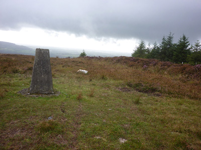
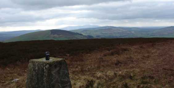
E (T03098 76082) I turned left and, continuing to follow the forest edge, walked out to the Trig Pillar marking the top of the hill. Unfortuately as the weather had closed in the views commented on by others were not seen apart from a glimpse of Croaghan Kinsella and Annagh Hill to the SE on my way down. Total distance walked 4.5km. Linkback: mountainviews.ie/summit/683/comment/15190/
Read Less
Read More

            MountainViews.ie picture about Ballycumber Hill (<em>Cnoc Bhaile an Chomair</em>)
Picture: The view from the summit cairn, Blackstairs in the distance
csd on Ballycumber Hill
by csd 16 Mar 2008
I parked at the bridge over the River Derry on the Wicklow Way, just off the R747 at Derry Rv (T021 744). I took the left turn after the bridge, and followed the Wicklow Way onto Coolafunshoge Lane, and old droving road. The lane meanders its way around the south of Ballycumber, and I took the left turn up to the summit near the area marked Mangans.
The summit affords some lovely views; Mount Leinster and the Comeraghs are visible to the south. I took a more direct route back to the Derry River, heading south down the spur before turning southwest to intercept Coolafunshoge lane again. Linkback: mountainviews.ie/summit/683/comment/2999/
Read Less
Read More

Kyle loop
by mickhanney 29 Jan 2011
Ballycumber hill is now readily accessible because of the new waymarked trails that have been developed around Tinahely. The Kyle loop is the longest of these walks and it traverses Ballycumber and joins the Wicklow way for a section. I've done this loop a no. of times now. The main advertised route starts at a trailhead at the top of Mangans lane but this means a 2k walk along a tarmaced lane, each way. Instead I usually park at the ford on the Wicklow way near Ballinglen and follow the route anti-clockwise from there. The waymarked trail is marked anticlockwise and this direction probably gives best views. Its a lovely route. The section from Kyle uphill is tough, particularly after rain as the ground here is quite soft. Good views to reward the effort though. Linkback: mountainviews.ie/summit/683/comment/6224/
Read Less
Read More
EDIT Point of Interest
text
Videos


Users Online
jackos, nupat, Muscles1960, madfrankie, Daingean, RangerBrian, lauracardiff, Alatar
Guests online: 255
Recent Contributions
x
Conditions and Info
Use of MountainViews is governed by conditions and a privacy policy.
Read general information about the site.
Opinions in material here are not necessarily endorsed by MountainViews.
Hillwalking is a risk sport. Information in comments, walks, shared GPS tracks or about starting places may not be accurate for example as regards safety or access permission. You are responsible for your safety and your permission to walk.
See the credits and list definitions.

OSi logo
OSNI/LPS logo
Open Street Map
(Various variations used.)
British summit data courtesy:
Database of British & Irish Hills