Cookies.
This website uses cookies, which are small text files that the website puts on your device to facilitate operation. Cookies help us provide a better service to you. They are used to track general user traffic information and to help the website function properly.
Features
Nearby features appear when you click the map.
Declutter tracks on map.
Place Search
Video
X
Pub: by
Dartry Mountains Area , NE: Arroo Keeloges Subarea
Feature count in area: 31, by county: Leitrim: 22, Sligo: 10, of which 1 is in both Sligo and Leitrim, OSI/LPS Maps: 16, 17, 25, 26
Highest Place: Truskmore 647m

Starting Places (22) in area Dartry Mountains:
Aghavoghil Middle, Arroo Trail CP, Ballaghnatrillick, Ballintrillick Forest, Barrs East, Castletown, Crumpaun, Curraghan Road, Dough Mountain NW, Dough Mountain West, Drumcliff River Road, Eagles Rock, Edenbaun, Glencar Waterfall, Gleniff Horseshoe Road, Lough Cloonaquin North, Luke's Bridge, Mountain Wood, Poulveha River, Thur East, Tormore Car Park, Truskmore Transmitter Entrance

Summits & other features in area Dartry Mountains:
N: Truskmore: Gortnagarn 445m, Tievebaun 611m, Truskmore 647m, Truskmore SE Cairn 631m
NE: Arroo Keeloges: Aganny Top 482m, Aghalateeve 432m, Agow Top 423m, Arroo Mountain 523m, Conwal North 421m, Crocknagapple 372m, Keeloges 452m
NW: Benbulbin: Annacoona Top 597m, Benbulbin 526m, Benwiskin 514m, Benwiskin South Top 508m, Kings Mountain 462m
SE: Manorhamilton Hills: Ballaghnabehy Top 413m, Benbo 415m, Dough Mountain 462m, Lackagh Mountain 449m, Larkfield 305m, Naweeloge Top 441m, Thur Mountain 442m
SW: Castlegal Hills: Copes Mountain 452m, Crockauns 463m, Hangmans Hill 400m, Keelogyboy Mountain 438m, Keelogyboy Mountain Far East Top 418m, Keelogyboy Mountain NE Top 435m, Keelogyboy Mountain SW Top 417m, Leean Mountain 417m

Note: this list of places may include island features such as summits, but not islands as such.
Rating graphic.
Keeloges, 452m Hill
Place Rating ..
, Leitrim County in Connacht province, in Carn Lists, Keeloges is the 731st highest place in Ireland.
Grid Reference G81266 50155, OS 1:50k mapsheet 16
Place visited by: 48 members, recently by: Colin Murphy, Overarroo, andalucia, conormcbandon, Haulie, marymac, TommyMc, Wilderness, Welder, 40Shades, magnumpig, rollingwave, FrankMc1964, MichaelG55, LorraineG60
I visited this place: NO (You need to be a logged-in member for this.)
Longitude: -8.289218, Latitude: 54.39965, Easting: 181266, Northing: 350155, Prominence: 87m,  Isolation: 1.5km
ITM: 581219 850155
Bedrock type: Dark fine-grained cherty limestone, (Dartry Limestone Formation)

  Short or GPS IDs, 6 char: Klgs, 10 char: Keeloges

Linkback: https://mountainviews.ie/summit/611/
Gallery for Keeloges and surrounds
Summary for Keeloges : Go and enjoy.
Summary created by Colin Murphy, simon3, Harry Goodman 2024-04-12 11:40:29
            MountainViews.ie picture about Keeloges
Picture: Looking SE to Keeloges, the top is middle right.
Route 1: Park at Church A (G803 503) on the R280 and walk south for 250m, to a gate and track on the left (the gate just before a sign for 'Concealed Junction.) Cross over and follow it E uphill towards the cliff face. Make for a gully with evidence of subsidence and, to the right of it, pick up a green lane that zig zags up the steep hillside. This leads up to the summit ridge and a good broad stoney surface near the SW end of Lough Keeloges B (G813 498). Turn left (N) for a short and easy climb up to the top. Route 2: On the Kinlough / Manorhamilton Road go E C (G796 515) along a minor road to a sharp bend left. A lane on the right D (G801 515) is the access route for the walk. In May 2010 a notice indicated "Private Road - No Entry". This most likely relates to vehicles but permission to walk up should be sought at one of the houses. The lane soon becomes an unsurfaced track that leads up towards the Keeloges escarpment and then skirts around it's N end. At E (G819 506), about 2.5k along leave the track and go SW (right) steeply uphill staying well clear of the escarpment edge on the right. Cross over a subsidiary top F (G814 504) before continuing SSW to the summit. Views from the top are extensive. To the W are Truskmore and Tievebaun while N, beyond Bundoran across Donegal Bay, is Slieve League and the long ridge of the Bluestacks. Closer at hand E is the Arroo Mt to Aganny top ridge. A combination of the two routes provides a satisfying looped walk but adds 2.5k of road walking to between the start and finishing points.
Linkback: mountainviews.ie/summit/611/comment/5370/
Member Comments for Keeloges
Comment create / edit display placeholder

            MountainViews.ie picture about Keeloges
Picture: keeloges
majestic meanderings from Glenade
by gerrym 5 May 2010
Keeloges provides a striking counterpart to the vertical escarpments falling from Tievebaun and Truskmore across the floor of Glenade valley - a worthy rival to the more famous and travelled Glencar. It has a majestic presence from below - the rocky buttresses fitting like a well worn crown above steep scree spattered slopes.

The approach is as easy as could be, parking next to St Michaels church (G (G803 503)) which has loads of parking! A short walk south along the R280 brings a lane with an adjacent iron gate, cross the gate into the field and follow the path taken by tractors uphill. This leads easily uphill towards the towering slopes and cliffs ahead. A new fenceline and ditch have to be negotiated as head for a significant gully and landslip which has thrown a trail of debris far down the mountainside.

To the right of this gully a lush green track switches back and forth up the steep hillside, making surprisingly light work of the climb - this was late in the evening with fading light and a pack with camping gear. Looking along the slope aspect brought home just how steep it was and the clatter of falling stones as sheep crossed areas of scree confirmed my sight. As i neared the crest, between towers of rock on either side, a pair of ravens hovered not far overhead screeching at my presence in thier domain. The lights atop Truskmore casting an eerie glow as mist passed. On level ground the headtorch came out and i found my way to Lough Keeloges - the strong northerly wind pushing the water ashore. Tent pitched and hot food consumed a fairly comfortable night ensued, wind and the odd skiff of rain present on my hourly wake up.

Come morning a short hop and skip brought the prominent top, which provided a stunning vista across Glenade to the ice gouged sides of the valley and the heights of Truskmore and Tievebaun. My eyes roamed over the length of Donegal Bay from the heights of Slieve League to the Bluestacks, the beach at Bundoran and part of Lough Melvin. To the south were the crazily jumbled line of the Castegal Hills and the higher hills of Briefne culminating with Cuilcaigh.

A beautiful hill, imposing, dramatic and inspiring from below. From atop the views just add to the experience making this a relatively modest price to paid for the riches it pays out. Linkback: mountainviews.ie/summit/611/comment/4683/
Read Less
Read More

            MountainViews.ie picture about Keeloges
Picture: Making for Keeloges lesser top from summit, with Arroo Mt top right
A little gem of a hill
by Harry Goodman 8 Nov 2020
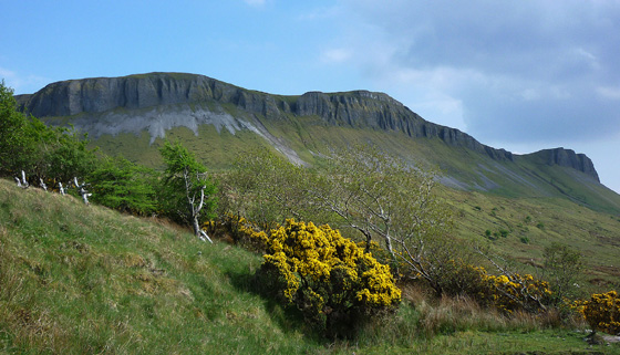
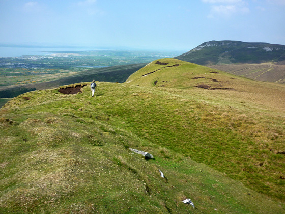
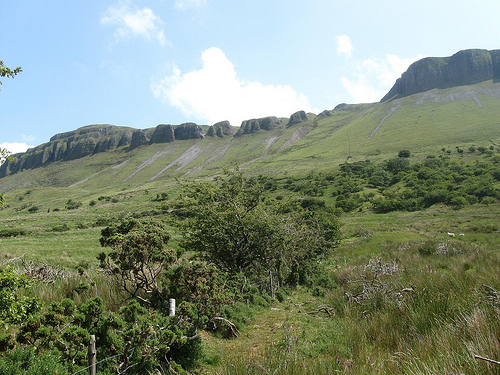
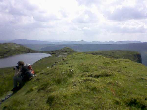
We approached Keeloges from the SE as the final hill in a round (Sat 22 May 2010) that had also included Arroo Mt, Aganny Top and Aghalateeve. (See also my comments on each of the other hills.) From Aghalateeve we dropped down NW to cross a stream, and then up to Pt 442 
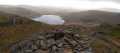
H (G81400 49725), passing across flat marshy ground with a number of small fenced in boggy areas. Pt 442 is a rocky promontory just S and above beautiful Lough Keeloges nestling in a hallow below the tiny summit of Keeloges. Our route took us down to the Lough and then around and along its W side, on a good stoney surface, for the short and easy climb up to the top and a superb viewpoint. This final hill of the day proved to be one of great character, with suberb views in whatever direction we choose to look. Close at hand to the W, or so it seemed, were the high hills of the Dartry Range, Tievebaun and Truskmore, while N beyond Bundoran across Donegal Bay was Slieve League and the long ridge of the Bluestacks. E across the valley was Arroo Mt our first top of the day and SW was the bumpy ridge of the Castegal Range across Glencar. This is a top on which to sit and while away a bit of time simply soaking up the atmosphere and scenic delights all around. We did just that. When there we met another walker who told us he was intending to descend by the zig zags on the steep escarpment just below and to the W of Lough Keeloges. Indeed from where we were sitting we could clearly see his intended path zig zaging down the slope. However as this route would have added an extra 2k of roadwalking back to the car we opted to continue with the planned route down. We descended by following the edge of the escarpment down NNE then up and over a subsidiary top before dropping down steeply and carefully away from the precipitous edge to meet a well constructed farm track I (G81900 50600), which we followed down for some 2.8k to the road and the sting in this "tale". On the way down, near the road there were a number of houses and, while we could hear voices from time to time we did not meet up with any of the residents. At the road was a notice indicating that the track we did come down was a " Private Road- No Entry". At the road we turned right and had a walk of about !k back to the start of our round J (G80481 52522). For anyone wishing to follow our round or to use the farm track for access it would be prudent to seek permission at one of the houses near the start of the track. More wisely I would suggest that you use the access to or from the hill by way of the zig jag path mentioned to us by the walker we met on the top and also identified by gerrym in his post of 5 May 2010 starting or finishing at St Michaels Church in Glenade K (G80300 50300). In total our round of the four tops (Arroo Mt, Aganny Top, Aghalateeve and Keeloges) was just under 18k and a memorable and rewarding day in the hills. Without doubt this is a hill well worth climbing in its own right. Linkback: mountainviews.ie/summit/611/comment/5848/
Read Less
Read More

            MountainViews.ie picture about Keeloges
Picture: Keeloges from Glenade
madfrankie on Keeloges
by madfrankie 3 Jul 2009
We approached Keeloges head-on from Glenade. Once you've negotiated the rough farmland you can pick up the nettle-infested zig-zag track that steeply ascends to the summit plateau. Keeloges's grassy summit knoll rises to your left, and as you continue, the lovely Lough Keeloges comes into view. It even has a tiny beach. Linkback: mountainviews.ie/summit/611/comment/3898/
Read Less
Read More

            MountainViews.ie picture about Keeloges
Picture: Keeloges Summit
madfrankie on Keeloges
by madfrankie 3 Jul 2009
Not a very good shot, but I had to use my rather dodgy camera phone, having lost my camera on the ascent (thankfully found on the way back down) Linkback: mountainviews.ie/summit/611/comment/3899/
Read Less
Read More
EDIT Point of Interest
text
Videos

Recent Contributions
x
Conditions and Info
Use of MountainViews is governed by conditions and a privacy policy.
Read general information about the site.
Opinions in material here are not necessarily endorsed by MountainViews.
Hillwalking is a risk sport. Information in comments, walks, shared GPS tracks or about starting places may not be accurate for example as regards safety or access permission. You are responsible for your safety and your permission to walk.
See the credits and list definitions.

OSi logo
OSNI/LPS logo
Open Street Map
(Various variations used.)
British summit data courtesy:
Database of British & Irish Hills