This website uses cookies, which are small text files that the website puts on your device to facilitate operation. Cookies help us provide a better service to you. They are used to track general user traffic information and to help the website function properly.
Feature count in area: 20, all in Kerry,
OSI/LPS Maps: 70, 78, 83, EW-R
Highest Place: Coomacarrea 772m
Starting Places (24) in area Glenbeigh Horseshoe: Ballaghasheen Coilte, Ballaghasheen Pass Viewpoint, Cahernaman, Caunoge Boreen, Cloon Lough NE, Cloon Lough SE, Coolnahornan Bridge, Coomaclarig Bridge, Coomaglaslaw Outflow, Coomasaharn Lake, Coosatemple Cove, Coulagh Bridge Road, Drung Hill Layby, Gleensk Forest, Gleensk Viaduct, Glenbeigh Village, Lissatinnig Bridge Boreen, Lough Brista Wood, Lough Cappanlea OEC, Lough Caragh SW, River Behy Road, River Ferta Source, River Owroe Source, Roads Lough
Summits & other features in area Glenbeigh Horseshoe: Cen: Glenbeigh Horseshoe: Been Hill 651m, Beenmore 660m, Beenreagh 495m, Coomacarrea 772m, Drung Hill 640m, Keamconneragh 593m, Macklaun 607m, Meenteog 715m, Mullaghnarakill 665m, Teeromoyle Mountain 760m N: Glenbeigh: Callahaniska 219m, Coolroe 414m, Curra Hill 275m, Seefin 493m S: Caunoge: Caunoge 502m S: Knocknagapple: Colly 679m, Knocknagapple 466m, Knocknagapple NW Top 458m, Meenteog South-East Top 565m W: Mount Foley: Mount Foley 355m
Note: this list of places may include island features such as summits, but not
islands as such.
Knocknagapple, 466mHill Cnoc an Chapaill A name in Irish,
Place Rating ..
, Kerry County in Munster province, in Carn Lists, Knocknagapple is the 677th highest place in Ireland. Knocknagapple is the second most southerly summit in the Glenbeigh Horseshoe area.
Grid Reference V67130 79779,
OS 1:50k mapsheet 83 Place visited by: 60members, recently by: maoris, Beti13, bryanmccabe, Grumbler, John.geary, Jai-mckinney, Oscar-mckinney, Kirsty, Carolyn105, annem, omurchu, Taisce, chelman7, abcd, akelly810
I visited this place: NO (You need to be a logged-in member for this.)
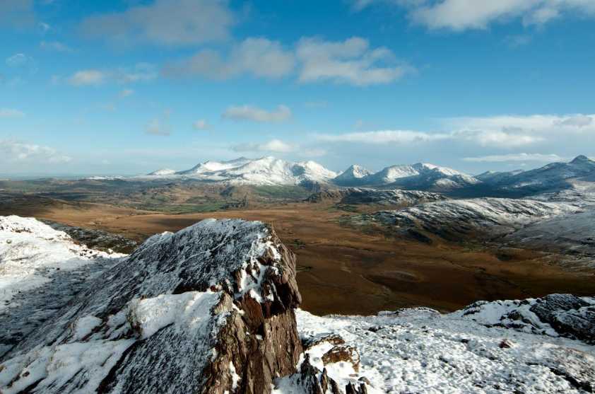
Little to add except that the views from these summits are some of the finest in the country with the whole of the Iveragh peninsula visible. The view in the photo is looking east to the Magillicuddy Reeks with the Dunkerrons to the right of these. Linkback: mountainviews.ie/summit/562/comment/17803/
Read Less
Read More
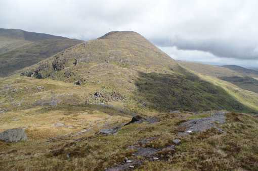
Picture: Knocknagapple from the south
Peter Walker on Knocknagapple
by Peter Walker
19 May 2009
On the map Knocknagapple looks like a very quick and easy excursion from the Ballaghisheen Pass (BSheen Ps (V671 792)) and so it (largely) proves, but there's a fair amount of outcropping rock to be tackled/outflanked, and a smidge of bog. A fence follows a line based upon (but not slavishly following) the ridge up to the top. If continuing to the NW Top it's worth bearing in mind that said fence pursues a rather 'athletic' line down to the connecting gap, and it's wise to descend a little way to the left or right. In the picture, taken from the facing slope of Knocknacusha across the pass, an Opel Corsa provides some scale (if you can see it). Linkback: mountainviews.ie/summit/562/comment/3772/
Read Less
Read More
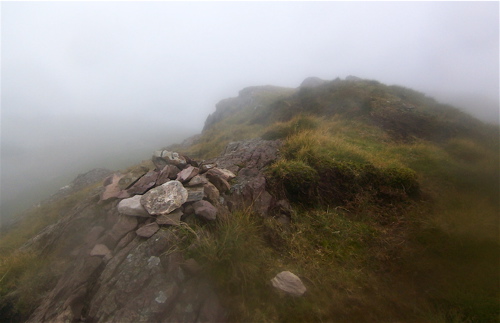
Picture: Summit marked by pile of stones.
colin murphy on Knocknagapple
by colin murphy
19 Aug 2009
Starting at Ballaghisheen Pass on a damp, misty day, the initial part of the ascent provided the opportunity to do a little rock-climbing over the many house-sized outcroppings that marked the apparent route upwards. Unfortunately the mist denied me the opportunity to enjoy what are undoubtedly wonderful views, but the rocky climb and narrow ridge at the top made it quite an interesting mountain to climb. Linkback: mountainviews.ie/summit/562/comment/4022/
Use of MountainViews is governed by conditions and a privacy policy.
Read general information about the site. Opinions in material here are not necessarily endorsed by MountainViews.
Hillwalking is a risk sport. Information in comments, walks, shared GPS tracks or about starting places may
not be accurate for example as regards safety or access permission. You are responsible for your safety and your permission to walk.
See the credits and list definitions.


 Our Facebook page.