This website uses cookies, which are small text files that the website puts on your device to facilitate operation. Cookies help us provide a better service to you. They are used to track general user traffic information and to help the website function properly.
Feature count in area: 38, all in Donegal,
OSI/LPS Maps: 1, 11, 2, 6
Highest Place: Errigal 751m
Starting Places (29) in area Derryveagh Mountains: Aleahan Lough, Altderry Bridge, An Chúirt Hotel, Astelleen Burn Waterfall, Derryreel Lough, Dunlewy Lough E, Dunlewy Lough Viewing Point, Errigal Hostel, Errigal Parking, Glenveagh Bridge, Glenveagh National Park SW, Glenveigh Castle, Keel Lough N, Losset North, Lough Acrobane Farmhouse, Lough Ascardan, Lough Barra Slipway CP, Lough Barra W, Meenagoppoge Burn Bridge, Mín Uí Bhaoil, Muckish Gap Shrine, Muckish North Access Road, Nabrackbaddy Lough, Procklis Lough, River Barra Bridge NE, River Barra Bridge SW, Sand Lough NE, Sruhancrolee Bridge, Stranamarragh Bridge
Summits & other features in area Derryveagh Mountains: Cen: Dooish: Dooish 651.5m, Dooish SW Top 528m, Dooish SE Top 553.9m, Saggartnadooish 506.4m, Saggartnadooish East Top 478.9m Cen: Errigal: Errigal 751m, Mackoght 555m Cen: Glenveagh Upper: Crockfadda 485m, Crockfadda East Top 454m, Crockballaghgeeha 480m, Crockmulroney 430m, Staghall Mountain 486m, Croaghnasaggart 480m, Maumlack 480m Cen: Lough Keel (Meencorwick): Crockglass 489m, Addernymore 416m, Grogan More 457m, Crocknafarragh 517m, Crocknafarragh SE Top 470m Cen: Slieve Snaght: Crockfadda 529m, Crockfadda NE Top 502m, Crocknasharragh 495m, Drumnalifferny Far NE Top 535m, Bingorms 578m, Drumnalifferny Mountain 596m, Drumnalifferny Mountain NE Top 585m, Slieve Snaght 678m N: Aghla: Aghla Beg 563.9m, Aghla Beg South Top 602.3m, Aghla More 581.2m, Ardloughnabrackbaddy 472.5m, Crocknalaragagh 470.6m N: Muckish: Muckish 667.1m, Croaghaderry 222m, Crockawama 238m, Derryreel 232m S: Doochary: Croaghleconnell 266m S: Dungloe: Crovehy 315m
Note: this list of places may include island features such as summits, but not
islands as such.
Saggartnadooish East Top, 478.9mHill Sagart na Dubhaise (mullach thoir) A name in Irish,
Place Rating ..
For origin of name, see Saggartnadooish., Donegal County in Ulster province, in Carn Lists, Saggartnadooish East Top is the 637th highest place in Ireland.
Grid Reference B99988 21632,
OS 1:50k mapsheet 6 Place visited by: 46members, recently by: annem, Colin Murphy, AlanReid, Kilcoobin, Carolyn105, gerrym, eamonoc, ilenia, finkey86, Lauranna, Fergalh, mountainmike, Lucky1, Reeks2011, Geo
I visited this place: NO (You need to be a logged-in member for this.)
Short or GPS IDs, 6 char: SgrtEs, 10 char: SgrtndEstT Linkback: https://mountainviews.ie/summit/548/
Gallery for Saggartnadooish East Top (Sagart na Dubhaise (mullach thoir)) and surrounds
Summary
for Saggartnadooish East Top (Sagart na Dubhaise (mullach thoir)):
Boulder topped spur overlooking Derryveagh Valley
Summary created by simon3, march-fixer
2012-10-04 12:45:07
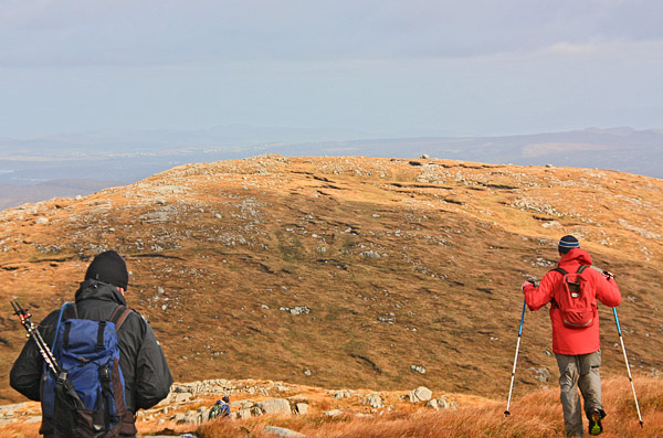
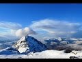
Picture: Saggartnadooish E from the west.
The smallest of the hills at the NE end of the Derryveagh Range, gathered close by to the east of Dooish, with commanding views north, east and south.
It can be reached easily from the R251 via Saggartnadooish. There are a number of spots along here, like Meenagop (B96925 21779) , to safely park a number of cars just off-road. The lower reaches of this approach can be quite boggy. There is a handy access track A (B98056 22602) heading straight for Saggartnadooish and the peat workings which will bring you some of the way. The return trip should not take more than 2 hours.
The general area is untrammelled and exists in splendid isolation. Nothing seems to have changed here since the Ice Age, as evidenced by the enormous boulder deposited on the crown which, due to it's height, forms a most unusual, if not unique, summit. Its height was established with a surveying instrument.
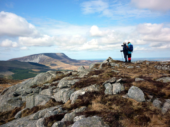
Picture: View across to Muckish from Saggartnadooish East Top
A splendid boulder strewn hill top.
by Harry Goodman
9 Jul 2011
I climbed this hill on 2 May 2010 as part of a circuit which included Dooish, Dooish SE Top and Saggartnadooish. For the first part of the route see my comments on Dooish SE Top. My original plan was to go from Dooish SE Top directly to Saggartnadooish E Top by walking NE down the spur to the Derrybeg Stream B (B99400 21250) and then continue on up to the summit. However given the excellent conditions on theday I decided we should head E to cross the stream further down and then go up to the knobbly top of Keamnacally C (C00600 20975) a small hill not listed on MV's. Once there we dropped down S over a number of grass and rock shoulders until we found a rocky ledge with superb views down to and along Glenveigh with the Castle particularly prominent far below.. It was only the next day when walking out the lakeside track S of the Castle that I realised this small hill is the high rocky ridge with a small bump halfway along which is prominent as one looks along the Glen from the NE end of the lake. From Keamnacally we headed up the broad ridge NW and then down to a coll before climbing up a long but gentle boulder strewn slope to the cairned top of Saggartnadooish E Top. There is a splendid panorama extending from Muckish across Sheephaven Bay to Melmore Head and Inishowen, then around to the distant Sperrins and SE across the Glendowan Mountains to the Bluestacks. From Saggartnadooish E Top we headed NW down to a coll before climbing to the rocky top of Saggartnadooish. Judging by the fact that this is the first comment posted for Saggartnadooish E Top I suspect it is not a top that many will climb for its own sake. For those minded to so do it would be possible to make a direct trip up and down from an appropriate point on the R251 but be prepared for a very boggy start up from the road to the point where you have to cross through the Deer Fence. For details of my route from Saggartnadooish E Top back to the R251 see my comments for Saggartnadooish. Linkback: mountainviews.ie/summit/548/comment/4720/
Use of MountainViews is governed by conditions and a privacy policy.
Read general information about the site. Opinions in material here are not necessarily endorsed by MountainViews.
Hillwalking is a risk sport. Information in comments, walks, shared GPS tracks or about starting places may
not be accurate for example as regards safety or access permission. You are responsible for your safety and your permission to walk.
See the credits and list definitions.


 Our Facebook page.