Cookies.
This website uses cookies, which are small text files that the website puts on your device to facilitate operation. Cookies help us provide a better service to you. They are used to track general user traffic information and to help the website function properly.
Features
Nearby features appear when you click the map.
Declutter tracks on map.
Place Search
Video
X
Pub: by
Derryveagh Mountains Area , N: Aghla Subarea
Feature count in area: 38, all in Donegal, OSI/LPS Maps: 1, 11, 2, 6
Highest Place: Errigal 751m

Starting Places (29) in area Derryveagh Mountains:
Aleahan Lough, Altderry Bridge, An Chúirt Hotel, Astelleen Burn Waterfall, Derryreel Lough, Dunlewy Lough E, Dunlewy Lough Viewing Point, Errigal Hostel, Errigal Parking, Glenveagh Bridge, Glenveagh National Park SW, Glenveigh Castle, Keel Lough N, Losset North, Lough Acrobane Farmhouse, Lough Ascardan, Lough Barra Slipway CP, Lough Barra W, Meenagoppoge Burn Bridge, Mín Uí Bhaoil, Muckish Gap Shrine, Muckish North Access Road, Nabrackbaddy Lough, Procklis Lough, River Barra Bridge NE, River Barra Bridge SW, Sand Lough NE, Sruhancrolee Bridge, Stranamarragh Bridge

Summits & other features in area Derryveagh Mountains:
Cen: Dooish: Dooish 651.5m, Dooish SW Top 528m, Dooish SE Top 553.9m, Saggartnadooish 506.4m, Saggartnadooish East Top 478.9m
Cen: Errigal: Errigal 751m, Mackoght 555m
Cen: Glenveagh Upper: Crockfadda 485m, Crockfadda East Top 454m, Crockballaghgeeha 480m, Crockmulroney 430m, Staghall Mountain 486m, Croaghnasaggart 480m, Maumlack 480m
Cen: Lough Keel (Meencorwick): Crockglass 489m, Addernymore 416m, Grogan More 457m, Crocknafarragh 517m, Crocknafarragh SE Top 470m
Cen: Slieve Snaght: Crockfadda 529m, Crockfadda NE Top 502m, Crocknasharragh 495m, Drumnalifferny Far NE Top 535m, Bingorms 578m, Drumnalifferny Mountain 596m, Drumnalifferny Mountain NE Top 585m, Slieve Snaght 678m
N: Aghla: Aghla Beg 563.9m, Aghla Beg South Top 602.3m, Aghla More 581.2m, Ardloughnabrackbaddy 472.5m, Crocknalaragagh 470.6m
N: Muckish: Muckish 667.1m, Croaghaderry 222m, Crockawama 238m, Derryreel 232m
S: Doochary: Croaghleconnell 266m
S: Dungloe: Crovehy 315m

Note: this list of places may include island features such as summits, but not islands as such.
Rating graphic.
Crocknalaragagh, 470.6m Hill Na Leargacha A name in Irish,
Place Rating ..
(Ir. Na Leargacha [OSI], 'the slopes'), Donegal County in Ulster province, in Carn Lists, Na Leargacha is the 664th highest place in Ireland.
Grid Reference B98435 26162, OS 1:50k mapsheet 2
Place visited by: 76 members, recently by: Colin Murphy, kernowclimber, mcrtchly, madfrankie, FoxyxxxLoxy, miriam, adam.mann, gerrym, jlk, jimmytherabbit, John.geary, annem, Haulie, f.sokol, thrifleganger
I visited this place: NO (You need to be a logged-in member for this.)
Longitude: -8.025286, Latitude: 55.082756, Easting: 198435, Northing: 426163, Prominence: 186m,  Isolation: 2.4km
ITM: 598385 926145
Bedrock type: Whitish quarztite with pebble beds, (Ards Quartzite Formation)
Notes on name: This peak is located between Muckish and the Aghlas and overlooks the Muckish Gap.
  Short or GPS IDs, 6 char: Crcknl, 10 char: Crcknlrggh

Linkback: https://mountainviews.ie/summit/545/
Gallery for Crocknalaragagh (Na Leargacha) and surrounds
Summary for Crocknalaragagh (Na Leargacha): A "busy" hilltop.
Summary created by jackill, Harry Goodman 2012-03-18 08:30:23
            MountainViews.ie picture about Crocknalaragagh (<em>Na Leargacha</em>)
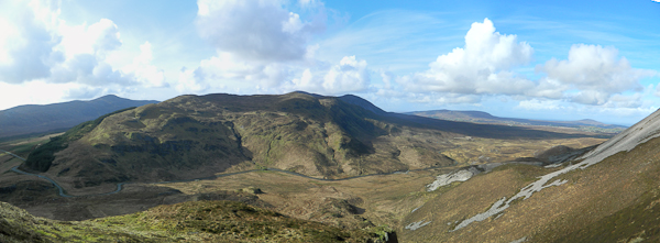
Picture: As viewed from Muckish
Park at Muckish Gap A (B998 269). Climb up the steep enbankment NW and then follow up along the forest edge (on left) for some 600m to Pt 384 B (B995 264) Continue further along for another 500m to Pt. 431 C (B992 261) where a change of direction to due W (right) is necessary to gain the high point about 2k from the start. The top of this hill is quite expansive and "busy" with many humps and hallows all above the 400m contour. For this reason finding the top in poor visibility could prove tricky unless care is taken with navigation, hence the number of checkpoints given. There are three small loughs on Crocknalaragagh, all above 400m, which are all within close proximity of each other should a visit to them be required. While there are views N to Muckish, SW to the Agla Begs and across SE to the Dooish / Slieve Snaght ridge, the relatively low height of Crocknalaragh means they are more restricted than those from its higher neighbours. Most people probably climb this hill as part of a greater round of tops.
Linkback: mountainviews.ie/summit/545/comment/5304/
Member Comments for Crocknalaragagh (Na Leargacha)
Comment create / edit display placeholder

            MountainViews.ie picture about Crocknalaragagh (<em>Na Leargacha</em>)
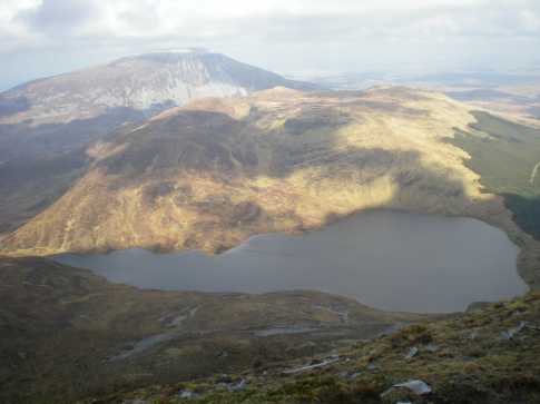
Picture: Lough Aluirg & Na Leargacha, with Muckish behind
vikinghar on Crocknalaragagh
by vikinghar 28 Oct 2008
Of the seven sisters in the Derryveagh range Na Leargacha must be considered the saddest. For most walkers, myself included, Na Leargacha is often considered as the barrier on the main walk to the Aghla’s. A mere footnote in walking terms. And I would still think of it in the same way had I not climbed it in full sunshine and with new eyes.

I walked Na Leargacha in early April 2008 when the sun was shining and the breeze would cut you in two, perfect walking weather, on my way to (you guessed it) the Aghla’s. But I soon gained a new respect for Na Leargacha for its wonderful rocky crags and cliff faces and I will consider climbing it again specifically, maybe as a circular walk.

OSI sheet 2 is the map to use. Getting to the start point is very easy, on the road from Letterkenny to Gweedore you will pass the entrance to Glenveagh National Park, about 2 or 3 miles on you will see a sign for Falcarragh on the right. This will lead you up to Muckish Gap where you can park beside the grotto. Behind the grotto is Muckish and much has been said about it, but turn around and face the other way and you will see the start of Na Leargacha(A (B998 269)). Interesting point, when I parked there last it was actually a hundred yards further on from the grotto and it offered a great view of the relatively dramatic northern face of Na Leargacha, crags and slopes galore.

From the start point, climb the steep slope, keeping as close as possible to the fence. The fence will guide you well to the top. Once you have past the forestry the top of the hill opens out onto sheep-grazed tundra. The actual top of Na Leargacha is 3 or 400 hundreds yards to the right of the fence line at D (B984 262). From there I went back to the fence and lunched on the sheltered northern shore of Lough Dog. From this point on, the view is dominated by the Aghla’s rising out of the far shore of Lough Aluirg. I descended with the upper crags on my right, skirted the top of the lower crags and descended with the lower crags on my left. I followed the stream down the Lough’s shore and rested at its northern exit (E (B971 256)).

As I said before I was on a mission to the Aghla’s, but for anybody that wanted to call it a day at this point will have a choice of exit, to return to Muckish Gap. You either follow the stream flowing out of the northern end of Lough Aluirg, called the Ballyness on the map, or you can exit at the southern end through the forestry. Either way will get you back to the road. The OSI map is pretty accurate as regards the lanes and bog roads in this area. Linkback: mountainviews.ie/summit/545/comment/3066/
Read Less
Read More
EDIT Point of Interest
text
Videos


Users Online
Djouce, GerryCarroll, MickM45
Guests online: 254
Recent Contributions
x
Conditions and Info
Use of MountainViews is governed by conditions and a privacy policy.
Read general information about the site.
Opinions in material here are not necessarily endorsed by MountainViews.
Hillwalking is a risk sport. Information in comments, walks, shared GPS tracks or about starting places may not be accurate for example as regards safety or access permission. You are responsible for your safety and your permission to walk.
See the credits and list definitions.

OSi logo
OSNI/LPS logo
Open Street Map
(Various variations used.)
British summit data courtesy:
Database of British & Irish Hills