This website uses cookies, which are small text files that the website puts on your device to facilitate operation. Cookies help us provide a better service to you. They are used to track general user traffic information and to help the website function properly.
Sperrin MountainsArea, NW Cen: Glenelly North West
Subarea
Feature count in area: 64, by county: Derry: 34, Tyrone: 39, of which 9 are in both Derry and Tyrone,
OSI/LPS Maps: 12, 13, 6, 7, 8
Highest Place: Sawel 678m
Starting Places (21) in area Sperrin Mountains: Altinure Road, Banagher Glen Nature Reserve, Barnes Gap Car Park, Crocknakin, Drumnaspar Picnic CP, Glenchiel Road, Glenedra Bridge, Glenelly Road, Parkreagh, Goles Road, Lough Ouske, Moneyneany Village, Moydamlaght Forest, Moydamlaght Road, Mullaghmore, Mullaghbane, Spaltindoagh, Sperrin Hamlet, Sperrin Heritage Centre, Sperrin Heritage Centre W, Sperrin Road, Barnes Top, Sperrin Road, Glashagh Bridge, Sperrin Road, Sperrin
Summits & other features in area Sperrin Mountains: E: Magherafelt Hills: Slieve Gallion NE Top 493.6m E: Magherafelt Hills: Slieve Gallion 526.6m N: Claudy Hills: Crockdooish 321m, Curradrolan Hill 270m, Eglish 277m, Letterlogher 249m, Mullaghmeash Hill 244m, Slieveboy 259m, Straid Hill 303m NE Cen: Glenelly North East: Barnes Top 456m, Craigagh Hill 460m, Crockbrack 526.1m, Knockanbane Mountain 441m, Meenard Mountain 620m, Meenard Mtn W Top 480m, Mullaghaneany 627m, Mullaghash 480m, Mullaghsallagh 485m, Oughtmore 569m, Spelhoagh 568m NE: Glenshane North: Benbradagh 465m, Boviel Top 454m, Carn Hill 448m, Carntogher 464m, Moneyoran Hill 414m NE: Glenshane South: Bohilbreaga 478m, Coolnasillagh Mountain 423m, Corick Mountain 430m, Crockalougha 407m, Mullaghmore 550m, White Mountain 537m NW Cen: Glenelly North West: Dart Mountain 619m, Dart Mountain North-West Top 525m, Learmount Mountain 489m, Learmount Mountain South Top 492m, Mullaghasturrakeen 581m, Mullaghcarbatagh 517m, Mullaghclogha 635m, Mullaghclogher 572m, Mullaghdoo 568m, Sawel 678m NW: Maheramason Hills: Clondermot Hill 220m, Gortmonly Hill 218m, Slievekirk 370m SE Cen: Glenelly South East: Carnanelly 562m, Carnanelly West Top 503.4m, Mullaghbane 467m, Mullaghturk 416m SE: Cookstown Hills: Cregganconroe 300m, Fir Mountain 362m, Oughtmore 382m SW Cen: Glenelly South West: Clogherny Top 408m, Craignamaddy 385m, Crocknamoghil 335m, Mullaghbolig 442m, Spaltindoagh 420m SW: Mullaghcarn: Curraghchosaly Mountain 416m, Mullaghcarn 542m, Mullaghcarn South Top 525m SW: Newtownstewart Hills: Bessy Bell 420m, Mullaghcroy 242m W: Strabane: Balix Hill 403m, Knockavoe 296m, Owenreagh Hill 400m
Note: this list of places may include island features such as summits, but not
islands as such.
Learmount Mountain South Top, 492mHill
Place Rating ..
For origin of name, see Learmount Mountain., Tyrone County in Ulster province, in no lists, Learmount Mountain South Top is the 595th highest place in Ireland.
Grid Reference H58354 97112,
OS 1:50k mapsheet 13 Place visited by: 61members, recently by: MickM45, madfrankie, Krzysztof_K, garybuz, Paddym99, Carolyn105, Aneta.jablonska, annem, abcd, Colin Murphy, wintersmick, Kilcoobin, trostanite, Hoverla, dregishjake
I visited this place: NO (You need to be a logged-in member for this.)
Short or GPS IDs, 6 char: LrmnMn, 10 char: LrmntMntnS Linkback: https://mountainviews.ie/summit/482/
Gallery for Learmount Mountain South Top and surrounds
Summary
for Learmount Mountain South Top :
Easily reached with a flat boggy top.
Summary created by simon3
2010-09-16 14:39:04
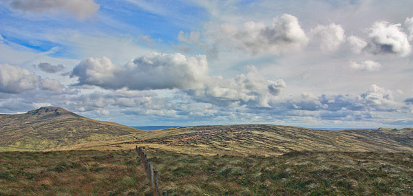
Picture: Centre is the flattish Learmount S Top with Dart Mtn to the left.
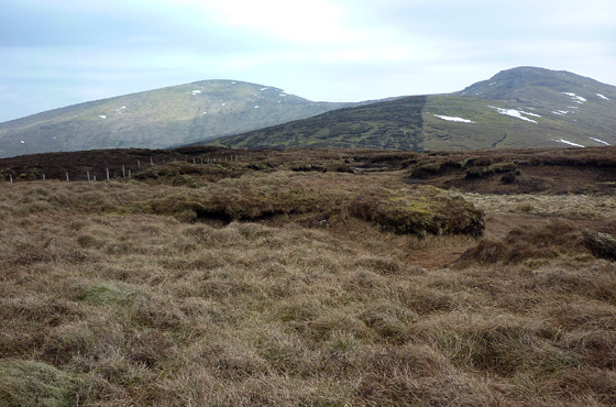
This is a summit that isn't included in the strict 400m list because it has such a slight prominence. Its attractions include good views of the Dart / Sawel ridge and views to the west including Donegal. It is on the main ridge of the high Sperrins so will see some visits on that account. An obvious way to reach this summit is by parking at A (H5389 9691) and walking the 600m or so to the top. The top is broad with peat hags and indistinct with no cairn.
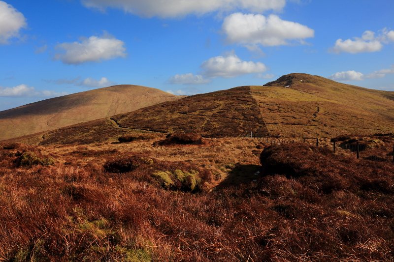
Picture: Looking E to Sawel and Dart from Learmount Mtn South Top
Learmount Mtn South Top
by Harry Goodman
8 Jun 2010
On 13 April 2010 I parked at one of the small pull in points B (H58957 97010) near the cattle grid at the crest of the Tamnaght Road from Crannagh to Park. I followed the fence running W up hill which took me unerringly to the top of the mountain and a junction with a second fence. Having spent some time stomping about the flat top I concluded that the summit lies a short distance from this fence at C (H58395 97103), just inside the E edge of the 490m ring contour. This said the area within the contour is some 100m across and others may,with some justification, argue that the top lies to the W across the fence at D (H58062 98278) or some other peaty hump. There is a fine view E across to Sawel and Dart. Descend by the way of ascent unless you also want to include Learmount Mountain in the walk (see also my comments on Learmount Mt site). Linkback: mountainviews.ie/summit/482/comment/4618/
Read Less
Read More
Picture: A view of Dart and Sawel on the ascent.
Peat Hag Hell
by Aidy
10 Mar 2015
The second summit of the day on Sunday, after Dart Mountain on the other side of the Tamnagh/Park road between Park and Cranagh. It is a very short walk from the road, and most of the height has been gained if parking at the highest point on the road near the cattle grids. The only difficulty was an area of peat hags at the summit, which I also had to navigate through on the way to my final summit, Learmount Mountain. Thankfully, torturous as it was, it wasn't that large an area and both mountains can be done easily. There are good views of the surrounding higher Sperrin peaks, and over Co. Derry. Linkback: mountainviews.ie/summit/482/comment/17875/
Use of MountainViews is governed by conditions and a privacy policy.
Read general information about the site. Opinions in material here are not necessarily endorsed by MountainViews.
Hillwalking is a risk sport. Information in comments, walks, shared GPS tracks or about starting places may
not be accurate for example as regards safety or access permission. You are responsible for your safety and your permission to walk.
See the credits and list definitions.


 Our Facebook page.