This website uses cookies, which are small text files that the website puts on your device to facilitate operation. Cookies help us provide a better service to you. They are used to track general user traffic information and to help the website function properly.
Feature count in area: 12, all in Mayo,
OSI/LPS Maps: 37, EW-CON, MSW
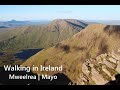
Highest Place: Mweelrea 814m
Starting Places (31) in area Mweelrea: Aasleagh Waterfall CP, Ben Creggan N, Bundorragha Estuary Cross, Bunleemshough River Source, Carraig Bar, Delphi Resort, Dernasliggaun, Doo Lough N, Doo Lough SE, Fee Lough SW, Foher, Glencraff Road End, Glencullin Lough CP, Glendavock, Glenummera River, Illaunroe North, Illaunroe South, Killary Boat Tour Pier W, Leenane, Leenane Hotel, unuseableLeenane R336, Lough Fee East, Muck Lough NW, Nambrackkeagh Lough, Owenduff River, Owengar Bridge, Owenwee River, Sean Scoil an Talaimh Bháin, Silver Strand Road, Tawnydoogan Forest Central, Tawnydoogan Forest North
Summits & other features in area Mweelrea: E: Ben Gorm Mountains: Ben Creggan 693m, Ben Creggan South Top 687m, Ben Gorm 700m W: Mweelrea: Ben Bury 795m, Ben Lugmore 803m, Ben Lugmore East Top 790m, Ben Lugmore West Top 790m, Corrymailley Hill 286m, Mweelrea 814m, Mweelrea SE Spur 495m, Tawnydoogan 312m, Teevnabinnia 379m
Note: this list of places may include island features such as summits, but not
islands as such.
Ben Bury, 795mMountain Ucht an Chreagáin A name in Irish,
Place Rating ..
(Ir. Ucht an Chreagáin [logainm.ie], 'breast of the little crag') Oughty Craggy an extra name in English, Ucht a Chreagaí, Mayo County in Connacht province, in Arderin, Vandeleur-Lynam, Irish Best Hundred Lists, Ben Bury is the third highest mountain in the Mweelrea area and the 45th highest in Ireland.
Grid Reference L80244 68290,
OS 1:50k mapsheet 37 Place visited by: 437members, recently by: nupat, NualaB, rhw, Hillwalker65, taramatthews, orlaithfitz, PiotrR, davidrenshaw, Carolineswalsh, Tuigamala, ronanmckee, ToughSoles, FoxyxxxLoxy, Kaszmirek78, Lyner
I visited this place: NO (You need to be a logged-in member for this.)
Longitude: -9.811829, Latitude: 53.650821, Easting: 80244, Northing: 268290,
Prominence: 60m, Isolation: 0.7km ITM: 480223 768308 Bedrock type: Sandstone & conglomerate, ignimbrite, (Mweelrea Formation) Notes on name: Also known as Oughty Craggy.
Short or GPS IDs, 6 char: BnBry, 10 char: Ben Bury Linkback: https://mountainviews.ie/summit/43/
Gallery for Ben Bury (Ucht an Chreagáin) and surrounds
Summary
for Ben Bury (Ucht an Chreagáin):
Flattish top, though steep north side with good views.
Summary created by Colin Murphy, scapania, simon3
2016-05-30 16:17:59
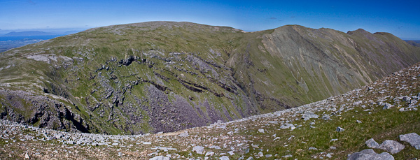
Picture: Ben Bury (left) is the flatter cousin to the peaky Ben Lugmores.
Unlike its pointy neighbours this summit is a 500m long East-West scarp. It has a steep northern side and broad high area to the south, lightly strewn with stones and boulders. It is easiest reached from the West via Mweelrea or East via "the Ramp" up from Coum Dubh (the Sruhauncullinmore valley). The Ramp starts at the east of the valley and takes you to the col between Ben Bury and Ben Lugmore (West). Other ways to reach the top include coming from the Ben Lugmores.
Access and parking is available from the R335 at the head of Doo Lough, at DooL N (L8282 6950).
Ben Bury has good views including towards Croagh Patrick twinned from its viewpoint with Nephin.
For alternative access as part of Mweelrea circular route see short summary for Ben Lugmore East Top. Having passed that summit along with Ben Lugmore and Ben Lugmore West Top, proceed NW for 1 km up gently rising, increasingly stony terrain. Ben Bury's broad summit is marked by two distinct cairns, the one to the east, or one nearer to Ben Lugmore is the highest by four metres.
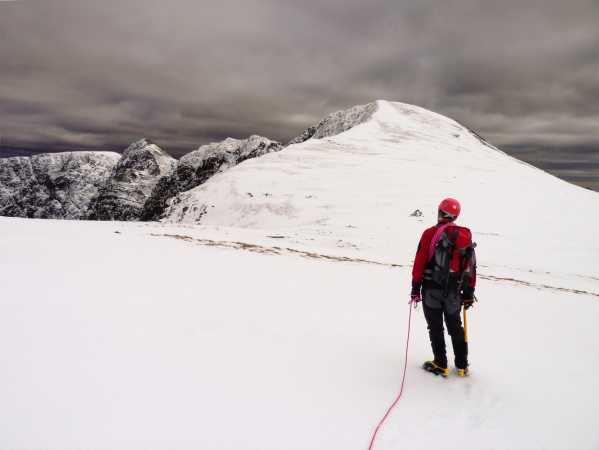
Picture: Excellent winter conditions on Lugmore Ridge
kernowclimber on Ben Bury
by kernowclimber
6 Apr 2010
We parked the car near a picturesque small jetty at the south end of Doo Lough at DooL SE (L845 677) and walked on the Dhulough Pass Road to find a track that meanders inland on the narrow neck of land between Doo Lough and Glencullin Lough towards the Sruhauncullinmore stream. Insects drifted languidly in the still air and the surface of Doo Lough was like a mirror which vividly reflected the snow covered mountains that we were to tackle. We took a route which led us over the Sruhauncullinmore stream towards the boggy bed of the coum and then headed right towards a grassy spur at the bottom of Ben Bury’s East Ridge.
After a hard pull upwards past some rocky outcrops on Glencullin we came to a strange line of sandstone boulders akin to a giant’s hedge, left behind eons ago by retreating ice. Here we paused for refreshment taking time to enjoy the view of the long ribbon of golden sand marking the boundary between land and sea near Barnaboun Point, the myriad islands beyond dancing and floating in the mottled sunlight reflecting off the vast expanse of ocean and, inland, the sun kissed snow covered peak of Croagh Patrick. The next part of the route became a scramble upwards over good grippy sandstone. The turf began to freeze and before long we were treated to the sight of a frigid lake. Patches of snow began to appear on the ground and after deciding to strike upwards for Ben Bury’s North East Ridge via a traverse of the north face of the mountain that was encrusted in places with icicles as thick as organ pipes, we put on our crampons and donned our ice axes.
We now moved steadily upwards following the tracks left by a fox. Once on the ridge we were treated to a good Scot I grade climb, and had to kick and cut steps on the steep ascent to the top. The views from here were breathtaking; Mweelrea, lit by shafts of sunlight radiating through broken cloud looked menacing and magnificent in its winter glory, and behind this rocky giant lay Killary Harbour shining like quicksilver.
We decided to forego this summit and opted instead for the Lugmore Ridge walk. Weaving round the corniced top of Glencullin cliffs via a narrow and thrilling arête we continued ESE along the ridge that drops towards Delphi. As we descended we removed our crampons to traverse Ben Lugmore. Below us lay a contorted, jumbled mass of rock which broke like an unwelcome and unending wave which called for yet more scrambling. We chose a direct and dizzying descent from this elongated mass of rock towards the inky blackness of Doo Lough to gain a sluice gate just west of the Owengarr River at the Doo Lough outflow. From here it was a short walk along the road to reach the car as the first stars began to glisten in a darkening sky to end a fantastic and challenging eight hour day in these most beautiful of mountains. Linkback: mountainviews.ie/summit/43/comment/4491/
Read Less
Read More
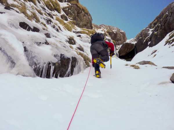
Picture: Climbing up the gully towards Ben Bury with the rock obstacle ahead
mcrtchly on Ben Bury
by mcrtchly
9 Mar 2010
Having climbed Ben Bury via a traverse of the north face and ascent of the NE ridge on the previous day we decided to try to tackle the mountain straight on by a direct winter ascent up a prominent gully at the western corner of the main Ben Bury corrie. The gully can be clearly seen on the approach in from Doo Lough as it leads upwards to the col between Ben Bury and Lugmore East Top. The top of the gully merges with the top of the 'ramp' route to Ben Bury. I don't know if the gully has been climbed much in normal conditions but in winter, filled with snow and ice, it was an opportunity not to be missed.
To reach the foot of the gully we walked into the corrie below Glencullin and followed the stream to the right before veering left and up to a short scree slope at the foot of an upward trending grassy ledge (A (L8091 6791)) at an altitude of about 460m. The grassy ledge soon turned out to be underlain by loose unconsolidated scree which made the going difficult until we reached the snow line. Soon the ledge began to peter out and we were forced to drop down about 8m into the gully proper (a rope belay was a necessary protection on the climb down). It may be possible to avoid the climb down by entering the gully lower down the hillside. Now the main ascent of the gully began at about 590m and continued almost straight upward for over 140m at a slope of 45 degrees or more up the col. There was deep snow in the gully and the use of crampons, ice axes and a rope were essential. In some parts we could kick steps in the snow but in other places the snow was too hard or the slope too steep that we had to cut steps with our ice axes. Before each step it was critical to lunge our axes fully into the snow to make a secure belay as any slip would probably be serious.
About half way up the gully there is a large boulder (or outcrop) which almost completely fills the gully. In normal conditions it might be possible to squeeze past this up a chimney on the left but on this day the chimney was blocked by unstable and hence unclimable ice. Fortunately this obstacle can be bypassed by a short climb out of the gully to the right before dropping back down in the gully after the boulder. From here onwards the gully narrowed and as we approached the top we were occasionally showered by ice debris being blown down the gully from the surrounding cliffs. Just before the very top the gully widens slightly and is joined by the 'ramp' route on the left and the combined gully and ramp soon open out onto the col.
I doubt if the gully comes into winter 'condition' that frequently and we were fortunate to be able to experience a challanging and different route up Ben Bury. I would estimate that the gully was a hard Scot I and even a Scot II grade. Linkback: mountainviews.ie/summit/43/comment/4490/
Read Less
Read More
Dan on Ben Bury
by Dan
29 Jul 2004
Theres a steep gully just to the west of the north eastern ridge that makes for a good scramble for a few hundred metres. Did it on a very windy and cold day and regularly got hammered by showers coming in from the north east, but it made it a bit more fun. The gully ends right at the top of the mountain. Got a nice surprise to haul myself up over a rock and find the summit cairn just a few metres in front of me. From the summit its quite an easy hike over to the summit of Mweelrea. Linkback: mountainviews.ie/summit/43/comment/1037/
Read Less
Read More
Picture: The summit cairn on Ben Bury, with Ben Lugmore West Top in the distance.
csd on Ben Bury
by csd
23 Nov 2005
As recommended by "Best Irish Walks", we parked at the northern shore of Doo Lough and approached from the Glencullin corrie. At first daunting, there's an easy enough route up using the left-to-right upwardly sloping ramp at the back of the corrie. The ramp brings you to the col between Ben Lugmore and Ben Bury, which is marked with a cairn. A right turn here brings you to Ben Bury's summit. Fantastic panoramas from the top, but unfortunately a late start meant we didn't have time to sample Ben Lugmore or Mweelrea. Heard the next day on the news that a party were lost on the mountain overnight, so heed Best Irish Walks' warning "...allow plenty of time, Mweelrea is an unforgiving mountain in the dark". Linkback: mountainviews.ie/summit/43/comment/2062/
Read Less
Read More
madfrankie on Ben Bury
by madfrankie
21 Aug 2006
After all the excitement of the Ben Lugmore ridge, Ben Bury proved to to be somewhat more prosaic. From Ben Lugmore West Top it's a short and easy slope to the broad col. Easy walking across a stony, grassless plateau to the summit cairn. Mind you, the views may be the best I've ever seen from a summit: the blue island-speckled atlantic to the west, and the bulk of Mweelrea to the south. Linkback: mountainviews.ie/summit/43/comment/2470/
Use of MountainViews is governed by conditions and a privacy policy.
Read general information about the site. Opinions in material here are not necessarily endorsed by MountainViews.
Hillwalking is a risk sport. Information in comments, walks, shared GPS tracks or about starting places may
not be accurate for example as regards safety or access permission. You are responsible for your safety and your permission to walk.
See the credits and list definitions.


 Our Facebook page.