Cookies.
This website uses cookies, which are small text files that the website puts on your device to facilitate operation. Cookies help us provide a better service to you. They are used to track general user traffic information and to help the website function properly.
Features
Nearby features appear when you click the map.
Declutter tracks on map.
Place Search
Video
X
Pub: by
Wicklow Area , S: Croaghanmoira Subarea
Feature count in area: 115, by county: Wicklow: 108, Kildare: 4, Wexford: 2, Carlow: 3, of which 1 is in both Wexford and Wicklow, of which 1 is in both Carlow and Wicklow, OSI/LPS Maps: 28B, 55, 56, 61, 62, AWW, EW-DM, EW-LG, EW-WE, EW-WS
Highest Place: Lugnaquilla 924.7m

Starting Places (205) in area Wicklow:
1916 Memorial Car Park, Aghavannagh Ow Bridge, Aghowle Wood, Altidore Wood Entrance, Annacurra National School, Annalecka Bridge, Asbawn Brook L8350, Aughrim National School, Ballard Road, Ballinabarny Gap, Ballinagappoge Bridge Layby, Ballinagappoge Mountain Hairpin, Ballinagore, Ballinahinch Wood, Ballinastoe MBT CP, Ballinastraw South, Ballineddan Upr Fork, Ballinfoyle Upr Cross, Ballycoog, Ballycreen Brook Bridge, Ballycumber, Ballycumber Bridge, Ballycumber Lane, Ballycumber Wicklow Way, Ballylerane, Ballylow Bridge, Ballylusk Quarry, Ballymanus Lane, Ballymoyle Shooting Lodge, Ballynultagh Gap, Ballynultagh Lane, Ballyreagh Wood, Ballyross Forest, Ballysmuttan Long Stone, Baravore, Barnbawn South, Barranisky North, Barranisky West, Bohilla Land Roundabout, Bohilla Lane Mid, Boranaraltry Bridge, Bray Harbour, Brewel West, Brittas Bay North CP, Buckroney Sand Dunes CP, Bus Terminus, Camera Hill Track Cross, Castletimon Wood North, Clara Vale, Clone House Road, Clonegal, Cloon Wood Cp, Coate Bridge, Coolballintaggart Ledge, Coolbawn House Lane, Cransillagh Brook , Crone Wood CP, Crossbridge, Crossoona Rath, Cummer Wood South, Curtlestown Wood CP, Deputy's Pass CP, Derralossary Church, Derry River Bridge, Devil's Glen CP, Devil's Glen Wood, Djouce Wood Calary, Djouce Wood Lake, Djouce Wood Long Hill, Donard, Donnelly's Lane Car Sales, Drumgoff Forest, Dunranhill North, Dunranhill SE, Dunranhill South, Dwyer McAllister Cottage CP, Enniskerry, Fentons Pub, Fitzsimons Park GAA, unuseableFlemings Footbridge Glen Rd, Gap Pub, Gap Road, Glen Beach CP, Glen of the Downs CP, Glenbride Lane, Glenbride Lodge, Glencree Reconciliation, Glendalough, Glenealy GAA, Glenmacnass Tonelagee CP, Glenmalure Hostel, Glenmalure Lodge, Glenmalure Waterfall, Glenview Hotel, Gowle House, Great Sugar Loaf CP, Grove Bar, Heffernans Well Wood, Hill View, Hollywood Glen, JB Malone CP, Johnnie Fox Pub, Keadeen NE trail, Keadeen Trailhead, Kevins Way Footbridge, Kilbride Army Camp Entrance, Kilcandra South, Kilcommon View, Killalongford Wood, Kilmacrea Cross Roads, Kilranelagh House Gate, Kilruddery Car Park, Kilruddery Cottages, Kings River, Kippure Bridge, Kippure Estate, Kippure Transmitter Gate, Knickeen Cross, Knocknaboley Lane Leeraghs Bog, Knocknaboley Lane Stone Cottage, Knockrath Little, Knockree west, Kyle Loop North, Lackan Wood S, Lake Dr Fraughan Brook, Lake Drive, Lake Park Cross, Lake View Pub, Laragh Free Car Park, Laragh NSch, Lead Mines CP, Liffey Bridge, Liffey Head Bridge, Lough Bray Lower, Lough Bray Upper, Lough Tay North Viewing Point, Lough Tay Wicklow Way CP, Luglass Lane L97561, Lugnagun Track, Macreddin Village, Mangans Lane, Military Road Carrigshouk Hill, Military Road Inchavore River Nth, Military Road Inchavore River Sth, Military Road NW Lough Tay, Military Road Ballyboy Bridge, Military Road Cloghoge Brook, Military Road Croaghanmoira, Military Road Fananierin, Military Road LaraghWicklow Way, Military Road Slieve Maan, Monspolien Bridge, Moortown House, Mountain Rescue HQ, Muskeagh Little Wood, Nahanagan Lough NE, Novara Avenue, Bray, Oiltiagh Brook Knickeen, Old Bridge Cross, Old Bridge Scouts , Old Wicklow Way entrance, Paddock Hill SE, Pier Gates CP, Powerscourt Waterfall CP, Putland Road, Quintagh East, Raheen Park CP, Raheenleagh East, Railway Walk CP, Rathdrum Railway Station, Rednagh Wood, Rocky Valley, Roundwood, Sally Gap, Sally Gap N, Seefin Trailhead, Seskin SE, Shankill Tributary Bridge, Shay Elliott, Sheepshanks Bridge, Shillelagh, Slievecorragh Track, Slievefoore South, Sraghoe Brook, St John's Church, St Kevins Chair, St Kevins Church, St Kevins Way R756, Stone Circle Bridge, Stookeen South, Stranahely Wood, Stranakelly Cross Roads, Tallyho, Templeboden, Tithewer, Tomcoyle L, Tomriland Wood, Toor Brook, Trooperstown Hill Access, Turlough Hill CP, Upper Lake CP, Vallymount GAA CP, Vartry Reservoir Upper, Zellers Pub

Summits & other features in area Wicklow:
Cen: Glendalough North: Brockagh Mountain 556.9m, Brockagh Mountain NW Top 549.5m, Brockagh Mountain SE Top 471.7m, Camaderry East Top 677.3m, Camaderry Mountain 698.6m, Conavalla 734m, Tomaneena 682.4m
Cen: Glendalough South: Carriglineen Mountain 456.6m, Cullentragh Mountain 510m, Derrybawn Mountain 476.1m, Kirikee Mountain 474.5m, Lugduff 653.2m, Lugduff SE Top 638m, Mullacor 660.7m, Trooperstown Hill 430m
N Cen: Tonelagee: Carrignagunneen 561m, Fair Mountain 571.2m, Stoney Top 713.7m, Tonelagee 815.8m, Tonelagee E Top 668m, Tonelagee South-East Top 545.8m
NE: Bray & Kilmacanogue: Bray Head Hill 238.9m, Carrigoona Commons East 242m, Downs Hill 372.9m, Great Sugar Loaf 501.2m, Little Sugar Loaf 342.4m
NE: Djouce: Djouce 725.5m, Knockree 342.1m, Maulin 570m, Tonduff 642m, Tonduff East Top 593m, War Hill 684.8m, White Hill 631.1m
NE: Fancy: Ballinafunshoge 480m, Kanturk 527.4m, Knocknacloghoge 532.4m, Luggala 593.3m, Robber's Pass Hill 508.9m, Scarr 640m, Scarr North-West Top 559.8m, Sleamaine 430m
NE: Vartry: Ballinacorbeg 336m, Ballycurry 301m, Dunranhill 342m, Mount Kennedy 365.9m
NW: Blessington: Carrigleitrim 408m, Lugnagun 446.2m, Slieveroe 332m, Sorrel Hill 599.5m
NW: Mullaghcleevaun: Black Hill 602.2m, Carrigshouk 572.5m, Carrigvore 682.4m, Duff Hill 720.8m, Gravale 719m, Moanbane 703m, Mullaghcleevaun 846.7m, Mullaghcleevaun East Top 796m, Silsean 698m
S: Aughrim Hills: Cushbawn 400m, Killeagh 249m, Moneyteige North 427m, Preban Hill 389m
S: Croaghanmoira: Ballinacor Mountain 529.3m, Ballycurragh Hill 536m, Ballyteige 447m, Carrickashane Mountain 508m, Croaghanmoira 662.3m, Croaghanmoira North Top 579.5m, Fananierin 426m, Slieve Maan 547.8m, Slieve Maan North Top 546.1m
S: Croghan Kinsella: Annagh Hill 454m, Croghan Kinsella 606m, Croghan Kinsella East Top 562.1m, Slievefoore 414m
S: Shillelagh Hills: Lakeen 357m, Monaughrim 206m, Seskin 344m, Stookeen 420m
S: Tinahely Hills: Ballycumber Hill 429.7m, Eagle Hill 296m, Muskeagh Hill 398.2m
SE: Wicklow South East: Ballinastraw 284m, Ballyguile Hill 188m, Barranisky 280m, Carrick Mountain 381m, Collon Hill 238m, Kilnamanagh Hill 217m, Westaston Hill 270m
W: Baltinglass: Ballyhook Hill 288m, Baltinglass Hill 382m, Carrig Mountain 571m, Carrigeen Hill 298m, Cloghnagaune 385m, Corballis Hill 258m, Keadeen Mountain 653m, Spinans Hill 409m, Spinans Hill SE Top 400m, Tinoran Hill 312m
W: Cen Lugnaquilla: Ballineddan Mountain 652.3m, Benleagh 689m, Camenabologue 758m, Camenabologue SE Top 663m, Cloghernagh 800m, Corrigasleggaun 794.6m, Lugnaquilla 924.7m, Slievemaan 759.7m
W: Donard: Brewel Hill 222m, Church Mountain 544m, Corriebracks 531m, Lobawn 636m, Slievecorragh 418m, Sugarloaf 552m, Table Mountain 701.7m, Table Mountain West Top 563m

Note: this list of places may include island features such as summits, but not islands as such.
Rating graphic.
Ballinacor Mountain, 529.3m Mountain Sliabh Bhaile na Corra A name in Irish,
Place Rating ..
, Slieveban, Wicklow County in Leinster province, in Arderin Lists, Ballinacor Mountain is the 477th highest place in Ireland.
Grid Reference T11707 86484, OS 1:50k mapsheet 62
Place visited by: 230 members, recently by: Sarahjb, SeanPurcell, ucampbell, Magic, Carolineswalsh, Alanjm, hudoyle, Kaszmirek78, pinchy, thmswhelan, MartaD, lauracardiff, Jonesykid, michaelseaver, Ansarlodge
I visited this place: NO (You need to be a logged-in member for this.)
Longitude: -6.340035, Latitude: 52.917908, Easting: 311708, Northing: 186484, Prominence: 48.1m,  Isolation: 1.8km
ITM: 711632 686520
Bedrock type: Quartzite, (Maulin Formation)
Notes on name: Ballinacor is the name of a townland, a parish and two baronies (Ballinacor South and North).
  Short or GPS IDs, 6 char: BlncMn, 10 char: BlncrMntn

Linkback: https://mountainviews.ie/summit/393/
Gallery for Ballinacor Mountain (Sliabh Bhaile na Corra) and surrounds
No summary yet for this place .
Member Comments for Ballinacor Mountain (Sliabh Bhaile na Corra)
Comment create / edit display placeholder

Ballinacor Mt.-Winter(ish) Decisions
by No1Grumbler 20 Dec 2020
Decades ago, I learned winter hiking was about being fit, early starts, short routes & flexible plans. I had spent 2020 lockdown with a keen regimen of Zoom meetings, I was 10kg heavier. None of the Grumblers were available, so I summoned three youngsters- the oldest of whom was 15 years my junior, what could go wrong? I was collected by Voortrekker, a natural outdoorsman who had honed his craft herding Giraffes across the veldt. He arrived not in a Land Rover with Zebra camouflage, but a silver Corolla. We sped to Glenmalure to assemble the party. We were joined 45mins late by Mr. and Mrs. Fuzz, who had spent the early years of the century covered in fluorescent paint at 72h dance marathons in Ibiza. Eric Shipton never had these problems. We did the mask thing and left a car at a forestry entrance (Point E) before returning to the military Rd ( MlRd Fan (T1019 8927)
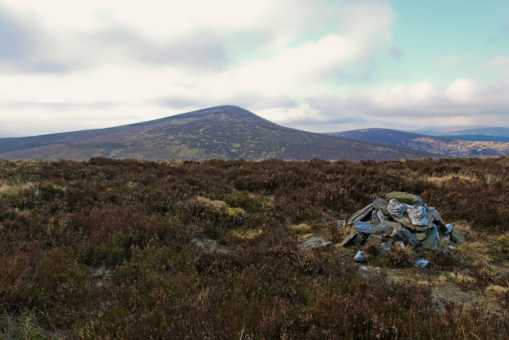
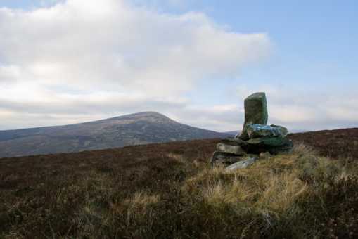
). By now it was nearly noon, two poor decisions in one morning. The third was the route: Fananieran ridge, Croaghanmoira, Ballinacor, back over to Carrickashane and down to car#2. We set off over the little bridge, and began up the rough trail to the ridge. Voortrekker sped off like a speeding bullet, with the stride of a man who could worry a warthog at 30 paces. Mr Fuzz was in hot pursuit. Mrs Fuzz, a yoga teacher, walked with me until she too wafted up the short climb. I could hear a sort of hissing sound -my breathing. With a heavy gait I reached the ridge. The youngsters looked they’d been discussing whether to put me out of my misery.
Rain and wind were in our faces now. We crested the North top, and made for Croaghanmoira proper, a glance at Carrickashane suggested a dull bogtrot. We fought the wind and pressed on. As the rain stopped, we decided on a late lunch below the summit on the North side, wonderfully sheltered. We were horribly late. Voortrekker offered me some Biltong that looked like Wildebeest droppings, I declined. Mr & Mrs Fuzz offered me their spicy homemade cake, I declined (last time I ate this I was found communing with mystical Celtic songlines-first good decisions today). As I drank my hot soup, I decided I wouldn’t collect four bad decisions. We decided to go to Ballinacor and find a route to the road. In low sun, we wandered faint trails to the NNE of Ballinacor and then a final 30m pull to the summit cairn. All was well, our next goal was the Ballycreen bridge. We should have taken a direct line (suggested elsewhere), but the siren call of a track in the valley saw us deviate to the W of the Ballycreen brook. Unfortunately, near the bridge, we met a deep transverse gully with slippery walls blocking our way, so we returned to the E bank and the semblance of a trail. At sunset we reached the road a mere 5.2km from our car. The sun set, a bright crescent moon, lit the road. It was a magical evening walk, we swapped tales to speed the journey, as I considered never walking with anyone under 40 again, to get fit and start early. Linkback: mountainviews.ie/summit/393/comment/21845/
Read Less
Read More

            MountainViews.ie picture about Ballinacor Mountain (<em>Sliabh Bhaile na Corra</em>)
padodes on Ballinacor Mountain
by padodes 19 Jan 2009
This may not seem a very pre-possessing mountain, but once one get to know its history, it begins to grow in stature. The stronghold of the O'Byrnes of Gabhal Raghnaill, a junior branch of the clan, was on the northern slope of Ballinacor (‘Baile na Corra’: the homestead of the slope). It was especially during the time of Fiach McHugh O’Byrne, in the latter part of the 16th century, that Gaelic resistance to the English invader was at its height – and its most successful – in this mountainous area around Glenmalure. Fiach won a resounding victory over Lord Grey in Glenmalure in 1580, although it is here, too, that he was finally defeated and slain by Lord Russell in 1597. If you wish to learn more about the O’Byrnes of Ballinacor, I would suggest a very informative article by Dr Harry Long of Trinity College, which you will find reproduced on http://homepage.eircom.net/~nobyrne/Settlement_in_Feagh_OByrne_Ballinacor.htm

It seems that the word ‘baile’ in Ballinacor refers, not to a village in our modern understanding, but to a ‘rath’ kind of settlement of wooden structures surrounded by protected earthen ramparts. What remains of two of the original three enclosures can be seen today, not far from the Georgian residence known as Ballinacor House. From here the O’Byrnes could control the entrance to Glenmalure and the Avonbeg River valley down to Greenan and beyond.

As far as the summit of this flat mountain is concerned, there is a small cairn that it is easy to miss at A (T1170 8648) (see photo, with Croaghanmoira rising in the background). My own best guess before I stumbled over this, however, was a point at B (T1173 8653). Linkback: mountainviews.ie/summit/393/comment/3530/
Read Less
Read More

            MountainViews.ie picture about Ballinacor Mountain (<em>Sliabh Bhaile na Corra</em>)
padodes on Ballinacor Mountain
by padodes 20 Jan 2009
This is not the summit cairn on Ballinacor, although it has far more the appearance of that than the modest pile of stones that purports to mark the top, a short distance above it to the north. It can be found at C (T1172 8636). I have no idea what its significance may be. A boundary marker, perhaps, or the whim of idle hands?

In the ‘Leabhar Branach’, the late medieval work of bardic verse that sings the praises of the O’Byrnes, Ballinacor is called a “hunter’s haven”, and even today wildlife abounds on and around this mountain. I don’t think I have ever seen in one place such numbers of pheasant lower down or of grouse above. Here too, one warm day, I approached what I thought was an old branch sticking up out of the heather, when all of a sudden it became the antlers of a big stag that rose up from a hollow a few metres in front of me where he had been sunning himself. A look of surprise and disdain, and he was gone! Linkback: mountainviews.ie/summit/393/comment/3531/
Read Less
Read More

sbarany on Ballinacor Mountain
by sbarany 19 May 2005
Unfortunatelly, I have not read milo's comment before the walk and thus I visited Ballinacor (from Croaghanmoira). There were nothing (signpost, fence, warning) to indicate that walkers should keep off this top (or the area around it). There were no animals either, only walkers (one of them a local). Linkback: mountainviews.ie/summit/393/comment/1703/
Read Less
Read More

Jaak on Ballinacor Mountain
by Jaak 30 Oct 2005
Climbed this recently from the Aughavannagh to Greenane road. Initially the views along this road are of Croaghanmoira, but after you round that mountain Ballinacor comes into view on your left. I travelled to the point where the road was closest to the mountain - at a bridge beside an acute bend. A gate leads from the road to the mountainside and the summit is an easy 20-30 minute walk from there. The gate was unlocked and there were no signs suggesting there were any restrictions on climbing from this point. Linkback: mountainviews.ie/summit/393/comment/2026/
Read Less
Read More
EDIT Point of Interest
text
Videos


Users Online
jackos, Muscles1960, ToughSoles, learykid, Dee68, Haulie, eamonoc, therealcrow
Guests online: 238
Recent Contributions
x
Conditions and Info
Use of MountainViews is governed by conditions and a privacy policy.
Read general information about the site.
Opinions in material here are not necessarily endorsed by MountainViews.
Hillwalking is a risk sport. Information in comments, walks, shared GPS tracks or about starting places may not be accurate for example as regards safety or access permission. You are responsible for your safety and your permission to walk.
See the credits and list definitions.

OSi logo
OSNI/LPS logo
Open Street Map
(Various variations used.)
British summit data courtesy:
Database of British & Irish Hills