This website uses cookies, which are small text files that the website puts on your device to facilitate operation. Cookies help us provide a better service to you. They are used to track general user traffic information and to help the website function properly.
Feature count in area: 16, all in Mayo,
OSI/LPS Maps: 22, 30, CBW, EW-ACC, EW-ACC
Highest Place: Croaghaun 688m
Starting Places (16) in area Achill & Corraun: Achillbeg Island, Achillbeg Mid West Beach, Barneygappul Strand, Belfarsad Bridge, Breanaskill, Bunanioo Church, Cartron River, Clare Island, Doogort Beach, Fiodián na Circe, Keem Bay, Lough Acorrymore, Lough Gall, Minaun Mast, Rossnafinna Island, Tobercolman Cross Cemetery
Summits & other features in area Achill & Corraun: Cen: Minaun: Minaun (Achill Island) 466m N: Slievemore: Krinnuck (Achill Island) 214m, Slievemore (Achill Island) 671m NW: Croaghaun: Benmore (Achill Island) 332m, Cornaclea Hill (Achill Island) 269m, Croaghaun (Achill Island) 688m, Croaghaun SW Top (Achill Island) 664m S: Knockmore Achill: Achillbeg Island N Top (Achillbeg Island) 109.7m, Achillbeg Island S Top (Achillbeg Island) 108.5m, Knockmore (Achill Island) 337m, Tievereivagh (Achill Island) 286m SE: Corraun: Knocklettragh 452m, Corraun Hill 524m, Corraun Hill Highpoint 541m SW: Clare Island: Knockmore (Clare Island) 462m, Knocknaveen (Clare Island) 223m
Note: this list of places may include island features such as summits, but not
islands as such.
Corraun Hill Highpoint, 541mMountain Corraun Hill East Top A name in English,
Place Rating ..
(Ir. Cnoc an Chorráin [OSNB*], 'hill of the hook')Cnoc an Chorráin (pointe is airde) an extra name in Irish, Slieve Aghkerane, Mayo County in Connacht province, in Arderin, Irish Best Hundred Lists, Corraun Hill Highpoint is the 445th highest place in Ireland. Corraun Hill Highpoint is the second most easterly summit in the Achill & Corraun area.
Grid Reference L77736 96118,
OS 1:50k mapsheet 30 Place visited by: 124members, recently by: Padraigin, Carolineswalsh, srr45, CusackMargaret, Ansarlodge, farmerjoe, learykid, ochils_trekker, NualaB, paulbrown, Oscar-mckinney, Jai-mckinney, Carolyn105, johncusack, glencree
I visited this place: NO (You need to be a logged-in member for this.)
Longitude: -9.860862, Latitude: 53.900033, Easting: 77736, Northing: 296118,
Prominence: 506m, Isolation: 2.3km ITM: 477708 796120 Bedrock type: Red sandstone, conglomerate & mudrock, (Maam Formation) Notes on name: This peak is unnamed on OSI maps. However, the name Cnoc an Chorrain / Corraun Hill is used locally for the whole bulk of this mountain, not just for the lower western peak where this name is marked by OSI. Named Slieve Aghkerane on EastWest Corraun map, 2016. This version of the name comes from 'A New Map of Ireland' by Daniel Beaufort 1797 which is, in this area based on MacKenzie's sea charts of 1776 (Barry Dalby). Slieve Aghkerane is an unusual anglicisation of Ir. Sliabh an Chorráin, 'mountain of the hook'. It was the tradition for local children to gather bilberries on the mountain, and also another kind of small white berry called caora aitinn, which were bottled in whiskey, buried, and kept as remedies for ailments. This took place on the last Sunday of July, known locally as Garlic Sunday (apparently a corruption of 'garland') or Domhnach Chrom Dubh [MacNeill, 191-92]. Previously Cullydoo in MV.
Short or GPS IDs, 6 char: CrnHlH, 10 char: CrnHlHghpn Linkback: https://mountainviews.ie/summit/372/
Gallery for Corraun Hill Highpoint (Corraun Hill East Top) and surrounds
Summary
for Corraun Hill Highpoint (Corraun Hill East Top):
A simple straightforward route to the top
Summary created by simon3, Harry Goodman
2020-05-13 07:56:26
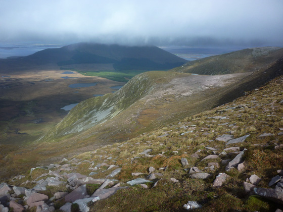
Picture: Corraun Hill East Top from Knockletragh
At A (F763 011) go south to B (L737 943). Take the good track up hill to a T junction. Leave the track and go NE up the hillside to a broad saddle (Pt 421) C (L761 957) and then E gently up the slope to a cairn D (L76839 95608). Continue NE for a further 1.25k over heather and increasingly stoney ground, past a number of cairns, to reach the top. This is a perfect vantage point to view Croagh Patrick, the Sheefrey Hills and Mweelrea to the SE and NE to the many tops of the Nephin Beg range. Descend SW back to the cairn at D (L76839 95608) and then continue down in the same direction for a further 2k to pick up the access track at E (L751 948). Follow the track down to the start.
To include Corraun Hill in a looped walk, from point D (L76839 95608) continue down W to the broad saddle (Pt 421) C (L761 957) and then go steeply uphill WNW to the summit trig pillar. Descend to the start at Buranioo Bridge as described in the short summary for Route 1 Corraun Hill.
Eight of us covered the three summits of the Corraun peninsula over a 24 hour overnight backpack. We took the way-marked track from just north of Bealfarsad church (where mass is every second Sunday for those inclined) at Belfarsad (L749 986) heading all the way to where it dead-ends at a tiny lough. A further 15 minutes south brought us to a patch of ground between Lough Laur and the fortune cookie-shaped Lough Cam at F (L774 973). We pitched the tents and after some respite took the, at times, steepish shoulder direct to the 476m point and directly onto Corraun East at 541m. The views extended across Clew Bay and the plethora of drumlins, though Croagh Patrick remained shrouded in cloud. The remainder of the walk over the saddle at 421m to Corraun Hill was straightforward with a gradual decent along the well defined ridge back towards the lake we would spend the night. The following day's hike to Knockletragh (locally named as Tonragee after the village on its northern flank) involved a pleasant stroll across the undulating bog where we dropped our heavy rucksacks at around the 200m elevation (G (L765 988)) and continued up the gentle slope to the top, returning the same way. The older OS maps show a track leading westward from our bag drop-off point towards the road but it is very rough and in some places non-existent (hence its removal from the 4th edition sheet).It is possible to push westward and join the loop track near the angle at H (L756 989). A 400m walk southward brought us back to our staring point. Having backpacked on Achill for many years and always bypassing Corraun, I can say that we will definitely be back to cover these summits again. We met nobody in the time we were there despite it being a warm, dry weekend in July. This area deserves much greater attention than it seems to get. Linkback: mountainviews.ie/summit/372/comment/17561/
Read Less
Read More
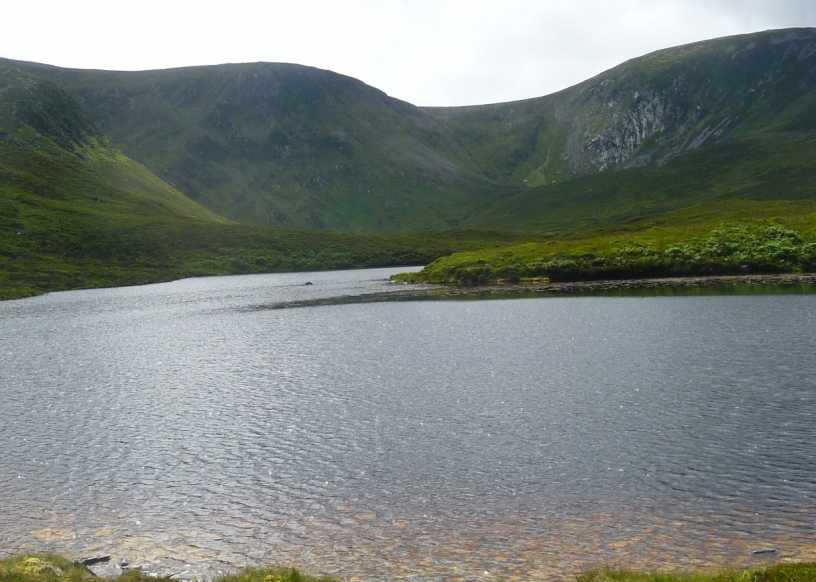
Picture: small L Cullylea with Nephin Begs in distance
gerrym on Corraun Hill Highpoint
by gerrym
8 Sep 2007
First a beware that the forest and tracks have change from that on my 1993 map and also that on Trailmaster West. Started out from eastern side of the hills, leaving the R319 as it follows the coast - onto a forest track at I (L804 997). There are opportunities to park and then follow track into the forest towards the steep sided corries reaching out to the northern side of the Corraun Hills, these really are impressive for the stature of the hills. After 25 minutes of walking through the forest I reached the Corrubeg river (J (L784 984)), following it up through difficult clearfell and then easier ground to the beautifully framed small corrie lough of Cullylea (K (L788 972)) - a large boulder provided a perfect spot to enjoy lunch nearly encircled by high rock walls. From here are several options to climb onto the higher ground nearly encircling the lough - i choose to climb steeply up 200m to the left of the lough (as on map) over scree and slippy heather clad ground - a tough half hour of puffing and panting, but rewarding going. The view from the corrie rim, across the opposite scree strewn side to Clew Bay and the Nepin Beg Mtns is amazing. Further easy climbing brings views down into the next corrie lough of Cullydoo and the long broad and stoney summit. There is a large cairn at the E end and a number of smaller ones along its 2km.The top brings ever wider views encompassing the range of mountains to the S (Croagh Patrick, Sheffrys, Mweelrea, Bens) the hills of Achill and the smaller though no less spectacular surrounding islands (Clare with its mini Croughaun) and again the full range of the mighty Nephin Begs. A short drop to a broad col and swift ascent brings Corraun Hill itself, slightly lower than that just traversed. I then descended by the NE ridge back to the forest, getting very confused by the changes to the landscape but eventually getting back to the start. Linkback: mountainviews.ie/summit/372/comment/2783/
Read Less
Read More
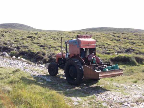
Picture: All aboard!
Of tractors and wasps
by wicklore
26 Aug 2011
I set off up the track at B (L737 943) on what was a very hot July day. This is a great track to gain height and warm up. I didn’t get the chance to warm up too much however as a kindly turf cutter trundled up on a curiously small tractor and told me to hop in the back. By this he didn’t mean jump in behind him – there wasn’t room. Instead I climbed into the miniature loader attached to the back of the tractor. I was just about able to stretch out comfortably sideways on top of his pile of empty turf bags and rain gear and off we set for a bouncy drive up the mountain! Purists might shout foul, but let me just say that we only went about 1km, and it was great craic! It saved me about 15 minutes on a 5 hour hike, and I learned more than a little about the effect of severe turbulence on photography!
I disembarked at E (L751 948) where the farmer was heading NW to his turf plot. It was a straightforward ramble a couple of kilometres NE over short heather to the col between the two Corrauns. As I climbed up to Corraun East Top I was reminded of the Sheefry’s, as the relatively flat plateau was similarly topped by fields of shattered rock interspersed with short grass. There are amazing views of Clare Island guarding the entrance to Clew Bay, with its north facing 460 metre cliffs plunging from its summit. By walking a little further east and south from the summit of Corraun East Top the full glory of Clew Bay comes into view, with its myriad islands. Across Clew Bay Croagh Patrick takes centre stage, holding its head high above the long east-west ridge of which it is the dominant summit. Further away to the SW the flat topped Sheefry’s are easily identifiable. The summits of Achill are also easily visible, while Slieve Carr and Nephin Beg appear out of the heat haze to the NE.
It is important to point out that there appears to be a wasp’s nest INSIDE the summit cairn on Corraun East Top. I watched them buzzing around and crawling in and around the cairn for a while. It’s remarkable that they chose such a high and exposed location, but obviously the cairn provides the shelter they need while they ply their trade on the flowers of the abundant heather on the surrounding slopes. The walk west to Corraun brings more of that ‘Sheefry’ feeling, as it involves crossing a wide flat col of short grass and rock. There are dramatic valleys and cliffs on the north of the Corraun massif which can be appreciated as you look back at Corraun East Top while ascending Corraun. The circuit of the two Corrauns took me five hours, which seems to be an hour longer than that suggested by others, so my jaunt in the tractor wasn’t such an unfair advantage after all! I’d suggest this walk is kept until a fine day as it would be a shame to miss the fantastic views in all directions. Linkback: mountainviews.ie/summit/372/comment/6490/
Read Less
Read More
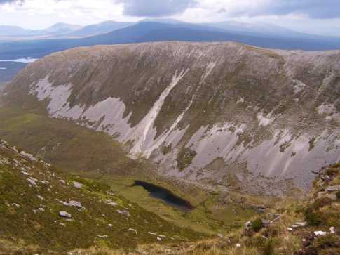
Picture: Looking NE to Knockletragh from the shoulder of Corraun Hill East Top.
Mist, mist and more mist!
by Harry Goodman
13 May 2020
Climbed Corraun Hill East Top on Wed 12 Oct 2011 as part of a round that also included Corraun Hill (See my comments on Corraun Hill for first part of the route). From the broad saddle (Pt 421) we went E very gently uphill to a cairn at D (L76839 95608). We then took a slight change of direction and went NE over increasingly stoney ground, past a series of cairns, to the summit cairn. Continuing thick mist ensured we had no views and made for a sharp turnaround back down SW to the cairn at D (L76839 95608) where we stopped for lunch. As we sat the mist started to lift and quite soon we had views across SW to Achill Beg and NW across the Sound. Before continuing down we went about 200m NW across the hillside to get a view down to the corries and small loughs below the N face of the Plateau (see photo). Although the mist persisted on the tops we were very pleased to have had an opportunity to see for ourselves some of the delights this hill has to offer for a future visit. From D (L76839 95608) we went SW down the long but gentle slope, over varied ground conditions, to the track at E (L751 948) which we then followed down to the road and back to the start. Linkback: mountainviews.ie/summit/372/comment/6592/
Read Less
Read More
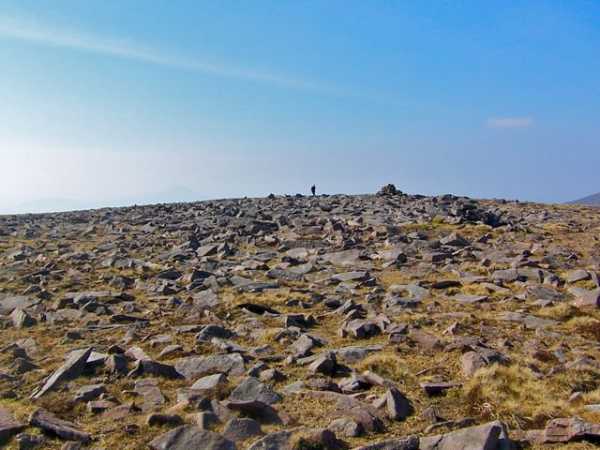
Picture: Rocky mountain high
Rocky mountain high
by Colin Murphy
26 Aug 2011
See Corraun comment for route. Picture shows the broad, extremely rocky and intriguing summit & cairn. Whoever built it wasn't short of material. Linkback: mountainviews.ie/summit/372/comment/6288/
Use of MountainViews is governed by conditions and a privacy policy.
Read general information about the site. Opinions in material here are not necessarily endorsed by MountainViews.
Hillwalking is a risk sport. Information in comments, walks, shared GPS tracks or about starting places may
not be accurate for example as regards safety or access permission. You are responsible for your safety and your permission to walk.
See the credits and list definitions.


 Our Facebook page.