Cookies.
This website uses cookies, which are small text files that the website puts on your device to facilitate operation. Cookies help us provide a better service to you. They are used to track general user traffic information and to help the website function properly.
Features
Nearby features appear when you click the map.
Declutter tracks on map.
Place Search
Video
X
Pub: by
Wicklow Area , S: Croaghanmoira Subarea
Feature count in area: 115, by county: Wicklow: 108, Kildare: 4, Wexford: 2, Carlow: 3, of which 1 is in both Wexford and Wicklow, of which 1 is in both Carlow and Wicklow, OSI/LPS Maps: 28B, 55, 56, 61, 62, AWW, EW-DM, EW-LG, EW-WE, EW-WS
Highest Place: Lugnaquilla 924.7m

Starting Places (205) in area Wicklow:
1916 Memorial Car Park, Aghavannagh Ow Bridge, Aghowle Wood, Altidore Wood Entrance, Annacurra National School, Annalecka Bridge, Asbawn Brook L8350, Aughrim National School, Ballard Road, Ballinabarny Gap, Ballinagappoge Bridge Layby, Ballinagappoge Mountain Hairpin, Ballinagore, Ballinahinch Wood, Ballinastoe MBT CP, Ballinastraw South, Ballineddan Upr Fork, Ballinfoyle Upr Cross, Ballycoog, Ballycreen Brook Bridge, Ballycumber, Ballycumber Bridge, Ballycumber Lane, Ballycumber Wicklow Way, Ballylerane, Ballylow Bridge, Ballylusk Quarry, Ballymanus Lane, Ballymoyle Shooting Lodge, Ballynultagh Gap, Ballynultagh Lane, Ballyreagh Wood, Ballyross Forest, Ballysmuttan Long Stone, Baravore, Barnbawn South, Barranisky North, Barranisky West, Bohilla Land Roundabout, Bohilla Lane Mid, Boranaraltry Bridge, Bray Harbour, Brewel West, Brittas Bay North CP, Buckroney Sand Dunes CP, Bus Terminus, Camera Hill Track Cross, Castletimon Wood North, Clara Vale, Clone House Road, Clonegal, Cloon Wood Cp, Coate Bridge, Coolballintaggart Ledge, Coolbawn House Lane, Cransillagh Brook , Crone Wood CP, Crossbridge, Crossoona Rath, Cummer Wood South, Curtlestown Wood CP, Deputy's Pass CP, Derralossary Church, Derry River Bridge, Devil's Glen CP, Devil's Glen Wood, Djouce Wood Calary, Djouce Wood Lake, Djouce Wood Long Hill, Donard, Donnelly's Lane Car Sales, Drumgoff Forest, Dunranhill North, Dunranhill SE, Dunranhill South, Dwyer McAllister Cottage CP, Enniskerry, Fentons Pub, Fitzsimons Park GAA, unuseableFlemings Footbridge Glen Rd, Gap Pub, Gap Road, Glen Beach CP, Glen of the Downs CP, Glenbride Lane, Glenbride Lodge, Glencree Reconciliation, Glendalough, Glenealy GAA, Glenmacnass Tonelagee CP, Glenmalure Hostel, Glenmalure Lodge, Glenmalure Waterfall, Glenview Hotel, Gowle House, Great Sugar Loaf CP, Grove Bar, Heffernans Well Wood, Hill View, Hollywood Glen, JB Malone CP, Johnnie Fox Pub, Keadeen NE trail, Keadeen Trailhead, Kevins Way Footbridge, Kilbride Army Camp Entrance, Kilcandra South, Kilcommon View, Killalongford Wood, Kilmacrea Cross Roads, Kilranelagh House Gate, Kilruddery Car Park, Kilruddery Cottages, Kings River, Kippure Bridge, Kippure Estate, Kippure Transmitter Gate, Knickeen Cross, Knocknaboley Lane Leeraghs Bog, Knocknaboley Lane Stone Cottage, Knockrath Little, Knockree west, Kyle Loop North, Lackan Wood S, Lake Dr Fraughan Brook, Lake Drive, Lake Park Cross, Lake View Pub, Laragh Free Car Park, Laragh NSch, Lead Mines CP, Liffey Bridge, Liffey Head Bridge, Lough Bray Lower, Lough Bray Upper, Lough Tay North Viewing Point, Lough Tay Wicklow Way CP, Luglass Lane L97561, Lugnagun Track, Macreddin Village, Mangans Lane, Military Road Carrigshouk Hill, Military Road Inchavore River Nth, Military Road Inchavore River Sth, Military Road NW Lough Tay, Military Road Ballyboy Bridge, Military Road Cloghoge Brook, Military Road Croaghanmoira, Military Road Fananierin, Military Road LaraghWicklow Way, Military Road Slieve Maan, Monspolien Bridge, Moortown House, Mountain Rescue HQ, Muskeagh Little Wood, Nahanagan Lough NE, Novara Avenue, Bray, Oiltiagh Brook Knickeen, Old Bridge Cross, Old Bridge Scouts , Old Wicklow Way entrance, Paddock Hill SE, Pier Gates CP, Powerscourt Waterfall CP, Putland Road, Quintagh East, Raheen Park CP, Raheenleagh East, Railway Walk CP, Rathdrum Railway Station, Rednagh Wood, Rocky Valley, Roundwood, Sally Gap, Sally Gap N, Seefin Trailhead, Seskin SE, Shankill Tributary Bridge, Shay Elliott, Sheepshanks Bridge, Shillelagh, Slievecorragh Track, Slievefoore South, Sraghoe Brook, St John's Church, St Kevins Chair, St Kevins Church, St Kevins Way R756, Stone Circle Bridge, Stookeen South, Stranahely Wood, Stranakelly Cross Roads, Tallyho, Templeboden, Tithewer, Tomcoyle L, Tomriland Wood, Toor Brook, Trooperstown Hill Access, Turlough Hill CP, Upper Lake CP, Vallymount GAA CP, Vartry Reservoir Upper, Zellers Pub

Summits & other features in area Wicklow:
Cen: Glendalough North: Brockagh Mountain 556.9m, Brockagh Mountain NW Top 549.5m, Brockagh Mountain SE Top 471.7m, Camaderry East Top 677.3m, Camaderry Mountain 698.6m, Conavalla 734m, Tomaneena 682.4m
Cen: Glendalough South: Carriglineen Mountain 456.6m, Cullentragh Mountain 510m, Derrybawn Mountain 476.1m, Kirikee Mountain 474.5m, Lugduff 653.2m, Lugduff SE Top 638m, Mullacor 660.7m, Trooperstown Hill 430m
N Cen: Tonelagee: Carrignagunneen 561m, Fair Mountain 571.2m, Stoney Top 713.7m, Tonelagee 815.8m, Tonelagee E Top 668m, Tonelagee South-East Top 545.8m
NE: Bray & Kilmacanogue: Bray Head Hill 238.9m, Carrigoona Commons East 242m, Downs Hill 372.9m, Great Sugar Loaf 501.2m, Little Sugar Loaf 342.4m
NE: Djouce: Djouce 725.5m, Knockree 342.1m, Maulin 570m, Tonduff 642m, Tonduff East Top 593m, War Hill 684.8m, White Hill 631.1m
NE: Fancy: Ballinafunshoge 480m, Kanturk 527.4m, Knocknacloghoge 532.4m, Luggala 593.3m, Robber's Pass Hill 508.9m, Scarr 640m, Scarr North-West Top 559.8m, Sleamaine 430m
NE: Vartry: Ballinacorbeg 336m, Ballycurry 301m, Dunranhill 342m, Mount Kennedy 365.9m
NW: Blessington: Carrigleitrim 408m, Lugnagun 446.2m, Slieveroe 332m, Sorrel Hill 599.5m
NW: Mullaghcleevaun: Black Hill 602.2m, Carrigshouk 572.5m, Carrigvore 682.4m, Duff Hill 720.8m, Gravale 719m, Moanbane 703m, Mullaghcleevaun 846.7m, Mullaghcleevaun East Top 796m, Silsean 698m
S: Aughrim Hills: Cushbawn 400m, Killeagh 249m, Moneyteige North 427m, Preban Hill 389m
S: Croaghanmoira: Ballinacor Mountain 529.3m, Ballycurragh Hill 536m, Ballyteige 447m, Carrickashane Mountain 508m, Croaghanmoira 662.3m, Croaghanmoira North Top 579.5m, Fananierin 426m, Slieve Maan 547.8m, Slieve Maan North Top 546.1m
S: Croghan Kinsella: Annagh Hill 454m, Croghan Kinsella 606m, Croghan Kinsella East Top 562.1m, Slievefoore 414m
S: Shillelagh Hills: Lakeen 357m, Monaughrim 206m, Seskin 344m, Stookeen 420m
S: Tinahely Hills: Ballycumber Hill 429.7m, Eagle Hill 296m, Muskeagh Hill 398.2m
SE: Wicklow South East: Ballinastraw 284m, Ballyguile Hill 188m, Barranisky 280m, Carrick Mountain 381m, Collon Hill 238m, Kilnamanagh Hill 217m, Westaston Hill 270m
W: Baltinglass: Ballyhook Hill 288m, Baltinglass Hill 382m, Carrig Mountain 571m, Carrigeen Hill 298m, Cloghnagaune 385m, Corballis Hill 258m, Keadeen Mountain 653m, Spinans Hill 409m, Spinans Hill SE Top 400m, Tinoran Hill 312m
W: Cen Lugnaquilla: Ballineddan Mountain 652.3m, Benleagh 689m, Camenabologue 758m, Camenabologue SE Top 663m, Cloghernagh 800m, Corrigasleggaun 794.6m, Lugnaquilla 924.7m, Slievemaan 759.7m
W: Donard: Brewel Hill 222m, Church Mountain 544m, Corriebracks 531m, Lobawn 636m, Slievecorragh 418m, Sugarloaf 552m, Table Mountain 701.7m, Table Mountain West Top 563m

Note: this list of places may include island features such as summits, but not islands as such.
Rating graphic.
Slieve Maan, 547.8m Mountain Sliabh Meáin A name in Irish,
Place Rating ..
(prob. Ir. Sliabh Meáin [PDT], 'middle mountain'), Wicklow County in Leinster province, in Arderin Lists, Slieve Maan is the 428th highest place in Ireland.
Grid Reference T08157 87958, OS 1:50k mapsheet 62
Place visited by: 253 members, recently by: davidrenshaw, MeabhTiernan, Carolineswalsh, Kaszmirek78, muddypaws, MartaD, michaelseaver, quarryman, Carolyn105, NualaB, John.geary, lauracardiff, Timmy.Mullen, Aneta.jablonska, marcellawalking
I visited this place: NO (You need to be a logged-in member for this.)
Longitude: -6.392305, Latitude: 52.931874, Easting: 308157, Northing: 187958, Prominence: 92.8m,  Isolation: 0.8km
ITM: 708082 687994
Bedrock type: Dark blue-grey slate, phyllite & schist, (Maulin Formation)
Notes on name: There are two peaks in South Wicklow of this name, though the other, near Lugnaquillia is written as a single word.
  Short or GPS IDs, 6 char: Slv548, 10 char: Slieve Man

Linkback: https://mountainviews.ie/summit/360/
Gallery for Slieve Maan (Sliabh Meáin) and surrounds
Summary for Slieve Maan (Sliabh Meáin): Wooded summit with easy access and poor views.
Summary created by simon3, mcrtchly 2013-11-19 17:46:42
            MountainViews.ie picture about Slieve Maan (<em>Sliabh Meáin</em>)
Picture: Small summit cairn.
Do not climb Slieve Maan for the views - there aren't any. Coniferous trees cover much of the mountain though there is a substantial ride along the line of the ridge near the summit. There are in fact two summits according to the Ordnance Survey and the SW summit has been determined as the higher. Initial access is via the Wicklow Way, mostly on forest tracks, either from the bottom of the Glenmalure valley at A (T10379 90517) or from the col on the Military Road at B (T08757 87599). Either follow the Wicklow Way uphill from Glenmalure or downhill from the col on the Military Road. Go to C (T08482 88198). Head west around 170m until you find a ride. Go down this SW for 250m to find a small cairn which is the top.
Following a differential GPS measurement in 2013, the SW top at around D (T082 880) was found to be around 1.68m higher than the NE one at an elevation of 547.82
Linkback: mountainviews.ie/summit/360/comment/5119/
Member Comments for Slieve Maan (Sliabh Meáin)
Comment create / edit display placeholder

            MountainViews.ie picture about Slieve Maan (<em>Sliabh Meáin</em>)
Picture: GPS at the higher top.
Maan on the Move
by jackill 17 Nov 2013
Well we finally got to it. A glance through the comments will show that the twin summits of Maan have caused debate on the site for some years now.
Simon and I got around to surveying both of them in November 2013.
The results are interesting on two counts.
Neither summit made 550 meters and the highest is not that shown on the map up to this point by MountainViews.
We measured the North east top (MV current summit) at 546.134 meters.
We measured the South west top at 547.819 meters.

So the summit location changes. Linkback: mountainviews.ie/summit/360/comment/15258/
Read Less
Read More

            MountainViews.ie picture about Slieve Maan (<em>Sliabh Meáin</em>)
Picture: The NE Top of Slieve Maan with cairn left of centre
Uninspiring !!
by Harry Goodman 18 Sep 2013
Although close, previously when walking the Wicklow Way, I had not actually been to the top of this hill. As it was one of two 500m tops in Wicklow that I had not climbed I decided to do so on 13 Sept. 2013. To say I found it uninspiring would be an understatement. However in the interests of anyone who wishes to climb Slieve Maan I thought the following comments might be helpful. I started from the forest entrance on the col below Croaghanmoira, parking at E (T08750 87601) and followed the track W into the forest. At the road I had noticed that the Wicklow Way which followed this route was re-directed N down the Military Road and not into the forest. A short way in I came across a sign which explained the re-routing, access was restricted beyond that point to authorised personnel. Fortunately for me some men were working there and as no forestry operations were being carried out that morning they agreed that I could continue my walk. However they also advised that due to the track closure walkers should use the next forest entrance signed for the Drumgoff Recreational Area at DrGof Fst (T094 889) some 2km further NE down the Military Road. Continuing on, with permission, I sought out the overgrown forest break at F (T08600 88518) and must agree that overgrown is certainly a very apt description. Indeed if it were not for some evidence of foot fall on the bank up into the forest one could be excused for missing it. My thanks are due to mcrtchly for pointing the way. From here I headed up NW twisting and weaving my way through the moss covered trees for some 300 metres to emerge out on to quite a large clear grass and peat hagged area with the the NE Top clearly identified by an old cairn at 
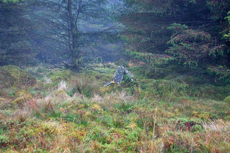
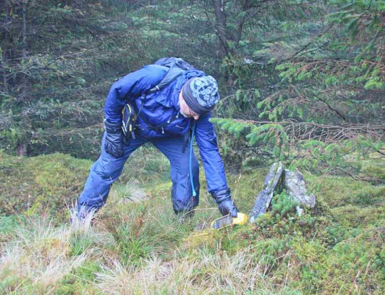
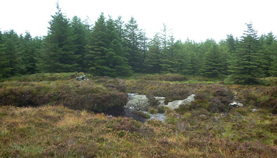
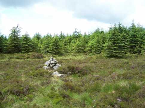
G (T08395 88733), the MV listed high point for the hill, and close to a small pond. Once back down at the track, I decided to seek out the SW top at 
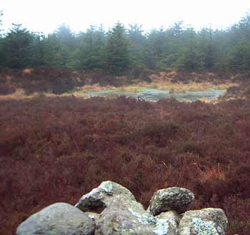
D (T082 880). Though ill-defined it is located on a long narrow grassy area near to the line of an old fence and is even less interesting than it's twin some 800 metres to the NNE. While much of the forest below the SW Top has been harvested the top area is still surrounded by trees. My route was initially along a very rough vehicle track which led me up the side of the cleared hillside before I left it and went up through the trees to the top. From there I descended down E out onto the cleared hillside and back down to my outward track. In all this short detour added about 500 metres to a walk of 4.5km. Linkback: mountainviews.ie/summit/360/comment/15186/
Read Less
Read More

            MountainViews.ie picture about Slieve Maan (<em>Sliabh Meáin</em>)
simon3 on Slieve Maan
by simon3 13 Apr 2003
This mountain's summit is part of a long ridge going SW-NE. You can get near to it using a track that leads NW from the Wicklow Way through the trees. Reaching the top of the ridge of this track you turn right and walk through some trees for around 150m to reach the summit. (OK -- this is easiest with a GPS). As of 2003 the trees were relatively open. The summit is marked with a small cairn and has a number of boggy ponds. There is another top marked for Slieve Maan about 800m north. The height for this is also given at 550 m on the map. We have selected the more southerly one as the summit because that's what the OS map says and the older 1/2 inch maps also say it is the highest (at a height of 1800 as opposed to 1797 feet). The photo shows the cairn and its surrounds. Linkback: mountainviews.ie/summit/360/comment/438/
Read Less
Read More

            MountainViews.ie picture about Slieve Maan (<em>Sliabh Meáin</em>)
csd on Slieve Maan
by csd 9 Nov 2003
This picture shows the views over to Ballycurragh Hill from the southern slopes of Slieve Maan. There's a forest ride that runs NE from the north west corner of the cleared area on the southern side of Slieve Maan, which leads you past both 550m summits. It's shown on the Healy map, but Sheet 62 doesn't go into this sort of detail. Linkback: mountainviews.ie/summit/360/comment/738/
Read Less
Read More

            MountainViews.ie picture about Slieve Maan (<em>Sliabh Meáin</em>)
padodes on Slieve Maan
by padodes 12 Jul 2007
I know that MountainViews has given its preference to the SW top of Slieve Maan rather than to the NE one, of roughly the same height. The OS map and, correspondingly, the Healy Glendalough/Glenmalure maps have led the way in this regard. Just for the sake of completion, however, let me add a photo of the less favoured NE "top". In reality it is simply a pile of stones in a flat forest clearing. I would have had difficulty finding it had it not been for the SMC contour map on my GPS, which for some reason has chosen to indicate the NE top as the principal one. Although the forest ride that runs parallel to the two tops is a pleasant walk, the encroaching afforestation limits the views considerably. (On the nearby Carrickashane Mountain, the problem becomes even more oppressive.) I was agreeably surprised, though, to see the familiar white triangle of the Great Sugarloaf exactly in line with the ride as I followed the track in its north-eastward direction. Linkback: mountainviews.ie/summit/360/comment/2770/
Read Less
Read More
EDIT Point of Interest
text
Videos


Users Online

Guests online: 261
Recent Contributions
x
Conditions and Info
Use of MountainViews is governed by conditions and a privacy policy.
Read general information about the site.
Opinions in material here are not necessarily endorsed by MountainViews.
Hillwalking is a risk sport. Information in comments, walks, shared GPS tracks or about starting places may not be accurate for example as regards safety or access permission. You are responsible for your safety and your permission to walk.
See the credits and list definitions.

OSi logo
OSNI/LPS logo
Open Street Map
(Various variations used.)
British summit data courtesy:
Database of British & Irish Hills