Cookies.
This website uses cookies, which are small text files that the website puts on your device to facilitate operation. Cookies help us provide a better service to you. They are used to track general user traffic information and to help the website function properly.
Features
Nearby features appear when you click the map.
Declutter tracks on map.
Place Search
Video
X
Pub: by
Dublin Area , S: Dublin South East Subarea
Feature count in area: 18, by county: Dublin: 16, Wicklow: 7, Kildare: 1, of which 6 are in both Dublin and Wicklow, OSI/LPS Maps: 43, 50, 56, AWW, EW-DM, EW-WE, EW-WW
Highest Place: Kippure 757m

Starting Places (77) in area Dublin:
Allagour Road, Ballinascorney Golf Club, Ballylerane, Ballylow Bridge, Ballyreagh Wood, Ballyross Forest, Ballysmuttan Long Stone, Barnaslingan Wood, Bohernabreena North CP, Boranaraltry Bridge, Bray Harbour, Cabinteely House, Cannon's Corner, Carrickgollgan, Castelkelly Bridge, Clonkeen Road South, Cloon Wood Cp, Cransillagh Brook , Crone Wood CP, Cruagh Forest Recreation Area, Cruagh Road Hairpin, Curtlestown Wood CP, Dunnes Bank, Enniskerry, Fernhill Estate, Gap Road, Garadhu Road, Glencree Reconciliation, Hell Fire Wood CP, Johnnie Fox Pub, Kilbride Army Camp Entrance, Kilgobbin Lane, Killakee Car Park, Killiney Hill Carpark, Kilmashoge Forest CP, Kilsaran Quarry, Kippure Bridge, Kippure Estate, Kippure Transmitter Gate, Knockbrack, Knockree west, Lackan Wood S, Lamb Doyles, Laughanstown Luas, Lee's Lane, Liffey Bridge, Liffey Head Bridge, Lough Bray Lower, Lough Bray Upper, Lynch's Park Road, Marley Park CP, Novara Avenue, Bray, Old Wicklow Way entrance, Pavilion Theatre, Pine Forest Road, Putland Road, Raheenoon, Rathmichael RC Church, Rathmichael Wood CP, Sally Gap, Sally Gap N, Seahan 265', Seahan 300', Sean Walsh Park, Seefin Trailhead, Shankill Byrnes Bar, Shankill Tributary Bridge, Slademore Road, Sraghoe Brook, St Catherine's Park, The Lamb Hill, The Scalp, Tibradden Forest Recreation Area, Tibradden Lane, Ticknock Forest, Vance's Lane, Wyattville Close

Summits & other features in area Dublin:
N: Howth: Ben of Howth 171m
N: Naul: Knockbrack 176m
S: Dublin South East: Carrickgollogan 275.2m, Glendoo Mountain 585.1m, Killiney Hill 153.5m, Knocknagun 555.3m, Montpelier Hill 383m, Prince William's Seat 553.5m, Tibradden Mountain 466.2m, Two Rock Mountain 536m
S: Kippure & Kilbride: Corrig Mountain 617.1m, Kippure 757m, Seahan 647.3m, Seefin 620.6m, Seefingan 722.9m
S: Saggart: Cupidstown Hill 378.6m, Knockannavea 400.8m, Saggart Hill 396.9m

Note: this list of places may include island features such as summits, but not islands as such.
Rating graphic.
Knocknagun, 555.3m Mountain Cnoc na gCon A name in Irish,
Place Rating ..
(prob. Ir. Cnoc na gCon [PDT], 'hill of the dogs') Cloghnagun an extra name in English, Cloch na gCon, Fitzwilliam's Seat, Dublin/ Wicklow County in Leinster province, in Arderin Lists, Knocknagun is the 404th highest place in Ireland.
Grid Reference O16328 18627, OS 1:50k mapsheet 56
Place visited by: 465 members, recently by: muddyboots, KateLeckie, davidrenshaw, Carolineswalsh, Kaszmirek78, Alanjm, Tommer504, Tuigamala, muddypaws, just.explores, michaelseaver, miriam, MariaT, lauracardiff, MichaelButler
I visited this place: NO (You need to be a logged-in member for this.)
Longitude: -6.259776, Latitude: 53.205614, Easting: 316328, Northing: 218627, Prominence: 63m,  Isolation: 1.4km
ITM: 716252 718656
Bedrock type: Pale grey fine to coarse-grained granite, (Type 2e equigranular)
Notes on name: Cloch na gCon, 'stone of the dogs', is the name of the remarkable boulder near the summit [PNCW].
  Short or GPS IDs, 6 char: Knc555, 10 char: Knocknagun

Linkback: https://mountainviews.ie/summit/351/
Gallery for Knocknagun (Cnoc na gCon) and surrounds
Summary for Knocknagun (Cnoc na gCon): Heathery Lump on Ridge.
Summary created by simon3, CaptainVertigo, Harry Goodman 2020-10-20 19:42:18
            MountainViews.ie picture about Knocknagun (<em>Cnoc na gCon</em>)
Picture: View of summit and tor from SW.
This is a heathery bump on the boggy track from Killakee towards Enniskerry. For a direct approach from the W park at the forest entrance Dunnes (O14133 18504). Follow track down and around forest edge passing over a bridge. Eventually leave the track and go left steeply up the bank along a narrow rough stoney path leading to an old quarry. Go up and around the left side of the quarry and then up E and then NE along a narrow but well trodden path through the heather. This leads to the top passing on the way between two large and distinctive rock outcrops A (O16105 18351). Near the top the path becomes less distinct before reaching the very striking crags which are a little south of the heathery summit, surveyed to be 555.4m. A walk of just over 6k, over peaty ground, that can be covered between 1.25 and 1.5 hours.
Otherwise reach this summit as part of a traverse including Glendoo and Prince William's Seat. For example Track 2035
Linkback: mountainviews.ie/summit/351/comment/5111/
Member Comments for Knocknagun (Cnoc na gCon)
Comment create / edit display placeholder

darrenf on Knocknagun
by darrenf 22 Jul 2009
Knocknagun is a natural extension of any trip to PWS. It has been well noted on this site of the boggy conditions between PWS and Knocknagun however on a recent visit to the area (18th July 09) while the conditions were soggy they were by no means impassable. Indeed there is a lot of backtracking and leap frogging to contend with but surely we are familair with this scenerio! Its a short leap to Knocknagun from PWS, 20 mins perhaps and its a trip I would recommend - the views are worthy of the short extension to the walk. Djouce, Maulin, Tonduffs, and Kippure with its eagle nest and corrie lakes are all in view. I dropped down to the forest edge between Knocknagun and PWS for my descent and took the track which handrails the forest edge. This eventually takes you to a series of wider forest tracks which will bring you to Cloon Carpark ( Cloon (O174 170)). Its a short sprint along the road back to Curtlestown Wood Carpark (B (O175 167)) where I began the walk. 2.5-3 hours in total should suffice to complete the loop of PWS and Knocknagun. Linkback: mountainviews.ie/summit/351/comment/3947/
Read Less
Read More

            MountainViews.ie picture about Knocknagun (<em>Cnoc na gCon</em>)
Picture: Ghostly Summit Spectres!
And out of the mist...........
by Dessie1 18 Oct 2011
Climbed Knocknagun on a miserable rainy misty Friday evening in September.Parked car at gateway to visible track C (O14102 18667).Followed track NE direction until I reached the col between Glendoo and Knocknagun(D (O15082 19356) roughly 510m height).I then took a SE direction to the summit of Knocknagun which out of the mist revealed an incredibly large summit Tor.E (O16367 18555) Linkback: mountainviews.ie/summit/351/comment/6587/
Read Less
Read More

            MountainViews.ie picture about Knocknagun (<em>Cnoc na gCon</em>)
Picture: Balancing act
padodes on Knocknagun
by padodes 6 Mar 2009


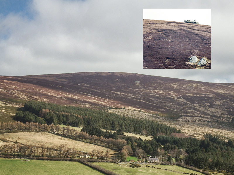
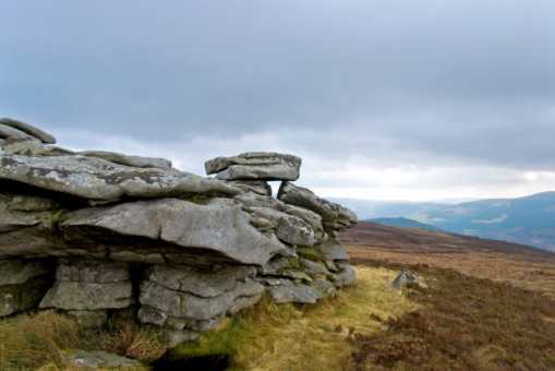
A visit to Knocknagun some time ago gave me the itch to find out more about the origin of ‘tors’, those layered, convoluted rocky outcrops that can be found, among other places, on or near the tops of a handful of our granite mountains in Dublin and Wicklow (see photo). Although they aren’t as abundant as those to be found on the granite landscapes of Dartmoor in England or the Mournes in the North, they are equally intriguing when it comes to trying to figure out the process of their geological formation. (The word ‘tor’, too, is interesting in itself, since it is one of the few Celtic survivals in the English language. It is related to the Irish ‘tor’ or ‘túr’ and the Welsh ‘twr’, meaning tower.)

In the 18th century, it was suggested that tors were artificial constructions raised by the druids, but that speculation was swept aside by the development of geology as a science. There was even a stormy ‘tor controversy’ in Britain, with a lot of hot air in the sails of several different theories. One of them, Linton’s two-stage theory, is still defended today and might provide a plausible explanation for our own homegrown variety. This theory argues that tors were first sculpted in the warmer Tertiary Period by the chemical action of acidulated underground water on the jointed, fractured granite bedrock, which caused decay along the cleavage lines. Essentially, the feldspar in the granite was altered to kaolinite (china clay). Later, during a phase of intense freeze/thaw conditions in the Quaternary Period, more exactly the Pleistocene, the decomposed rock was removed by a kind of soil creep, the downhill slippage of waterlogged sediment over the permafrost beneath. In this way the residual outcrops finally stood out in the light of day and were exposed, as they still are today, to the further destructive action of the elements.

It’s a simplification, I know, but I find it gives me a bit of perspective – several million years of it, in fact – when I visit Three Rock, Two Rock, Carrigvore, Knocknagun, or other long-suffering tors further afield. Linkback: mountainviews.ie/summit/351/comment/3622/
Read Less
Read More

Cloghnagun is also likely William's Seat
by barryd 23 Jan 2011
Prince William's Seat and Knocknagun. These are the OS names for two popular hills between Glencullen & Glencree and people often enquire as to the identity of Prince William. It has been suggested that it's named after William, son of George IV, after a royal visit in 1821. Whilst it's possible that there might be a connection with this, in the mind of the official responsible for collecting names at the time, I think it's probable that there is an older origin... Though it's impossible to be 100% definitive, the evidence points to another mix up here by the OS. If we look at maps that predate the OS survey, the situation is different.
For the detailed explanation of this with maps, please refer to the Placenames & Heritage part of my website at http://www.eastwestmapping.ie/placenames-heritage#p10 and scroll to the bottom. In summary, I think the evidence points to the hill labelled by the OS as Prince William's Seat should 'properly' be called Glencullen Mountain and the hill labelled by the OS as Knocknagun should be Cloghnagun with the name (Fitz)Williams Seat for the large granite tor there known as Cloch na gCon. Linkback: mountainviews.ie/summit/351/comment/6213/
Read Less
Read More

            MountainViews.ie picture about Knocknagun (<em>Cnoc na gCon</em>)
Picture: Rest in Peace
The German Graveyard
by wicklore 14 Mar 2011
Knocknagun rises on the north side of the Glencree Valley in Wicklow. and is distinguished by the large rock that sits near its summit. Travelling along the military road, the massive tor is highly visible on the otherwise featureless bog. However the hill also shelters a remarkably different piece of Irish history that is unique in all the land.

The western shoulder of Knocknagun sweeps down to meet the flank of Kippure above the hamlet of Glencree. This little settlement is home to the unique German Military Cemetery, which is situated in an old landscaped quarry. Under the exposed granite rock face sit several rows of crosses and plaques commemorating those German citizens who lost their lives in Ireland during World Wars I and II.

Although neutral, Ireland did not escape the effects of the military action during the wars. Several German military aircraft crashed here. These were due to poor weather, damage sustained over England, lack of fuel or navigational errors. Many German naval personnel were also found washed up around the country. In a sad twist of fate, the graveyard also contains the bodies of 46 German civilians who were being shipped from England to Canada for internment when their ship, the Arandora Star, was torpedoed by a German U-boat off Tory Island in Donegal in 1940. The graveyard also contains 6 soldiers from the First World War. They died while prisoners in a British prisoner of war camp located in Ireland.

Dr. Hermann Gortz is also buried at Glencree. As a spy, Gortz parachuted into County Meath in 1940. His mission was to enlist the IRA’s assistance during a potential German invasion of Britain. He was eventually arrested in possession of files on possible military targets in Ireland, as well as information on "Plan Kathleen". This was an IRA plan for the invasion of Northern Ireland with the support of the German military. Görtz was interned until the end of the war. When he was paroled in 1947 he was informed he would be deported to Soviet Germany. Terrified, he swallowed a cyanide capsule. He was buried in a Dublin cemetery, and in 1974 his remains were transferred to Glencree

In total there are 134 Germans buried in the Cemetery. This includes 81 naval and air service men, of whom the identities of only fifty three are known. The Cemetery is situated next to a rushing stream, which provides an atmospheric backdrop to the aura of this solemn and peaceful place. So if you are unfamiliar with this area and you happen to be walking along Knocknagun why not take the time to visit this quiet little corner of Irish history. A poem by Stan O Brien says it all:

“It was for me to die
.
Under an Irish sky

There finding berth

Under good Irish earth.

What I dreamed and planned

Bound me to my Fatherland.

But War sent me

To sleep in Glencree.

Passion and pain

Were my loss-my gain:

Pray, as you pass

To make Good my loss”
Linkback: mountainviews.ie/summit/351/comment/6273/
Read Less
Read More
EDIT Point of Interest
text
Videos


Recent Contributions
x
Conditions and Info
Use of MountainViews is governed by conditions and a privacy policy.
Read general information about the site.
Opinions in material here are not necessarily endorsed by MountainViews.
Hillwalking is a risk sport. Information in comments, walks, shared GPS tracks or about starting places may not be accurate for example as regards safety or access permission. You are responsible for your safety and your permission to walk.
See the credits and list definitions.

OSi logo
OSNI/LPS logo
Open Street Map
(Various variations used.)
British summit data courtesy:
Database of British & Irish Hills