Cookies.
This website uses cookies, which are small text files that the website puts on your device to facilitate operation. Cookies help us provide a better service to you. They are used to track general user traffic information and to help the website function properly.
Features
Nearby features appear when you click the map.
Declutter tracks on map.
Place Search
Video
X
Pub: by
Sperrin Mountains Area , NW Cen: Glenelly North West Subarea
Feature count in area: 64, by county: Derry: 34, Tyrone: 39, of which 9 are in both Derry and Tyrone, OSI/LPS Maps: 12, 13, 6, 7, 8
Highest Place: Sawel 678m

Starting Places (21) in area Sperrin Mountains:
Altinure Road, Banagher Glen Nature Reserve, Barnes Gap Car Park, Crocknakin, Drumnaspar Picnic CP, Glenchiel Road, Glenedra Bridge, Glenelly Road, Parkreagh, Goles Road, Lough Ouske, Moneyneany Village, Moydamlaght Forest, Moydamlaght Road, Mullaghmore, Mullaghbane, Spaltindoagh, Sperrin Hamlet, Sperrin Heritage Centre, Sperrin Heritage Centre W, Sperrin Road, Barnes Top, Sperrin Road, Glashagh Bridge, Sperrin Road, Sperrin

Summits & other features in area Sperrin Mountains:
E: Magherafelt Hills: Slieve Gallion NE Top 493.6m
E: Magherafelt Hills: Slieve Gallion 526.6m
N: Claudy Hills: Crockdooish 321m, Curradrolan Hill 270m, Eglish 277m, Letterlogher 249m, Mullaghmeash Hill 244m, Slieveboy 259m, Straid Hill 303m
NE Cen: Glenelly North East: Barnes Top 456m, Craigagh Hill 460m, Crockbrack 526.1m, Knockanbane Mountain 441m, Meenard Mountain 620m, Meenard Mtn W Top 480m, Mullaghaneany 627m, Mullaghash 480m, Mullaghsallagh 485m, Oughtmore 569m, Spelhoagh 568m
NE: Glenshane North: Benbradagh 465m, Boviel Top 454m, Carn Hill 448m, Carntogher 464m, Moneyoran Hill 414m
NE: Glenshane South: Bohilbreaga 478m, Coolnasillagh Mountain 423m, Corick Mountain 430m, Crockalougha 407m, Mullaghmore 550m, White Mountain 537m
NW Cen: Glenelly North West: Dart Mountain 619m, Dart Mountain North-West Top 525m, Learmount Mountain 489m, Learmount Mountain South Top 492m, Mullaghasturrakeen 581m, Mullaghcarbatagh 517m, Mullaghclogha 635m, Mullaghclogher 572m, Mullaghdoo 568m, Sawel 678m
NW: Maheramason Hills: Clondermot Hill 220m, Gortmonly Hill 218m, Slievekirk 370m
SE Cen: Glenelly South East: Carnanelly 562m, Carnanelly West Top 503.4m, Mullaghbane 467m, Mullaghturk 416m
SE: Cookstown Hills: Cregganconroe 300m, Fir Mountain 362m, Oughtmore 382m
SW Cen: Glenelly South West: Clogherny Top 408m, Craignamaddy 385m, Crocknamoghil 335m, Mullaghbolig 442m, Spaltindoagh 420m
SW: Mullaghcarn: Curraghchosaly Mountain 416m, Mullaghcarn 542m, Mullaghcarn South Top 525m
SW: Newtownstewart Hills: Bessy Bell 420m, Mullaghcroy 242m
W: Strabane: Balix Hill 403m, Knockavoe 296m, Owenreagh Hill 400m

Note: this list of places may include island features such as summits, but not islands as such.
Rating graphic.
Mullaghasturrakeen, 581m Mountain Mullach an Starraicín A name in Irish,
Place Rating ..
(prob. Ir. Mullach an Starraicín [PDT], 'summit of the steeple'), Tyrone County in Ulster province, in Arderin Lists, Mullaghasturrakeen is the 336th highest place in Ireland.
Grid Reference H54778 94972, OS 1:50k mapsheet 13
Place visited by: 95 members, recently by: Tricia-Mulligan, Paddym99, garybuz, Cecil1976, AlanReid, annem, osullivanm, abcd, srr45, wintersmick, Leonas_Escapades, Kilcoobin, No1Grumbler, dregishjake, dregish
I visited this place: NO (You need to be a logged-in member for this.)
Longitude: -7.149065, Latitude: 54.799605, Easting: 254778, Northing: 394972, Prominence: 46m,  Isolation: 1.2km
ITM: 654715 894962
Bedrock type: Psammite & semipellite, (Dart Formation)

  Short or GPS IDs, 6 char: Mlghst, 10 char: Mlghstrkn

Linkback: https://mountainviews.ie/summit/311/
Gallery for Mullaghasturrakeen (Mullach an Starraicín) and surrounds
No summary yet for this place .
Member Comments for Mullaghasturrakeen (Mullach an Starraicín)
Comment create / edit display placeholder

            MountainViews.ie picture about Mullaghasturrakeen (<em>Mullach an Starraicín</em>)
Picture: Spot the fence
Circuit with Mullaghclogha
by dr_banuska 25 Jan 2011
This dramatically-named mountain is often climbed as part of a traverse of 'the Mullaghs' - Mullaghcarbatagh and Mullaghclogher to the W and Mullaghclogha (highest peak in Tyrone) to the E. I had already climbed the first two as part of an earlier expedition that had to be abandoned due to intense fog, so just needed a handy start point for the two remaining peaks.

Heading W past the small village of Cranagh, I turned right up the minor road immediately before Glenroan bridge and a sign for Badony church. There's an old bar called The Glen just at the turn-off. Where the road forks, I headed right, up to a small forested area where there was room to park without blocking the road, about Glenelly Road, Parkreagh (H543 927)
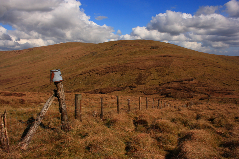
. Don't drive any further as the road becomes a track with a gate a bit further ahead, where it would be hard to turn again. Setting off, I crossed the gate after a few mins and where the track arcs off to the left towards an abandoned farmhouse, I crossed another (wonky) gate and headed onto open hillside where a faint track continues for a time over some small brooks.

You can clearly see the col between this peak and Mullaghclogher (to the W) and after a while I just aimed for this via the path of least resistance. It was a tough enough slog, with large snowy patches with the recent weather. The views quickly opened up however, S over the Glenelly Valley and beyond to Mullaghcarn with its masts, and Bessy Bell with its windfarm to the SW. I could see another windfarm E of Mullaghcarn which I couldn't identify (around Pomeroy/Carrickmore direction).

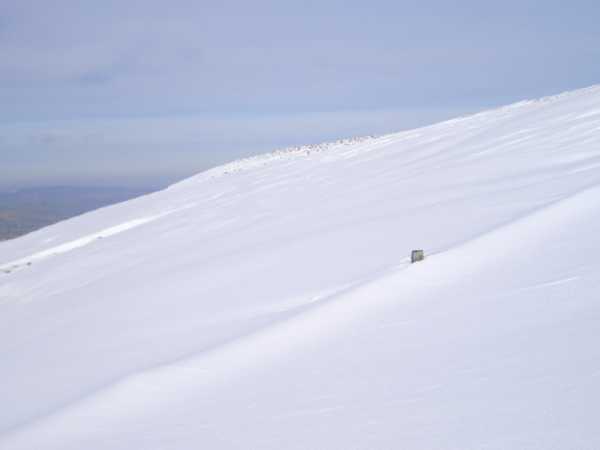
I was glad to finally meet the fence which ran along the col, but sudden exposure to freezing winds was a shock to the system. I headed W uphill over terrain that was now almost completely snow-covered. This was my first experience of walking in deep snow and it was certainly memorable. I stayed close to the fence and even it was completely submerged by snow at a couple of points! Quite unsettling. I was often waist deep and once or twice had to drag myself up on my hands and knees! By now the views had opened up towards Owenreagh and its windfarm to the W (just how many of these are there in Tyrone alone? they seem to be breeding), with the snow-capped Derryveagh Mtns far beyond in Donegal (flat-topped Muckish being the most recognizable), and NW towards Lough Foyle and the Inishowen hills.

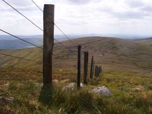
Luckily the going got a little easier towards the summit, marked typically by a meeting of fences. My next target, Mullaghclogha, could be seen clearly to the NE and thankfully proved a lot more manageable. Linkback: mountainviews.ie/summit/311/comment/4469/
Read Less
Read More

            MountainViews.ie picture about Mullaghasturrakeen (<em>Mullach an Starraicín</em>)
Picture: Mullaghasturrakeen from slopes of Mullaghclogha
gerrym on Mullaghasturrakeen
by gerrym 16 Sep 2006
Mullaghasturrakeen is perhaps more a challenge in terms of pronounciation than in actually climbing. It is perfectly placed between Mullaghclogher and Mullaghclogha to make a good days walking at the W end of the Genelly valley, along which the spine of the Sperrins stretch. The first part of this walk can be seen at Mullaghclogher where I have approached from when climbing this hill. From col with Mullaghclogher (A (H536 948)) climb west, steeply at first, then ground levels. Move away from fence to avoid large wet area. As climb pass rocky areas on northern slopes where ravens soar, to the south the glacial breach of Barnes Gap is in full view. The summit yet again is marked by the joining of fences. The views to the north and west are fantastic. Drop down north east following the fence line to the next col over some very wet ground. Again there are options to drop down south along the valley here to Glenelly Valley. I continued up next top of Mullaghclogha - see for continuation of this circuit. Linkback: mountainviews.ie/summit/311/comment/949/
Read Less
Read More

            MountainViews.ie picture about Mullaghasturrakeen (<em>Mullach an Starraicín</em>)
Picture: Bucket anyway...sorry, pail imitation of a joke.
Second Arderin Of The Day
by Aidy 1 Apr 2014
Approached this from Mullaghclogher, on the way to Mullaghclogha, on a very warm sunny day. Descending Mullaghclogher into a valley between the two along a col, there were some peat hags to negotiate and some boggy ground despite the good weather. It was simply a matter of following a fence from one summit to the other, as is common in the Sperrins, with great views along the way to the North and South, and the climb up was not as taxing as it looked from Mullaghclogher. Great day for a walk, and the Sperrins looking their best in the sunshine. Linkback: mountainviews.ie/summit/311/comment/15959/
Read Less
Read More
EDIT Point of Interest
text
Videos


Users Online
jackos, Muscles1960, ToughSoles, learykid, Dee68, Haulie, eamonoc, therealcrow
Guests online: 238
Recent Contributions
x
Conditions and Info
Use of MountainViews is governed by conditions and a privacy policy.
Read general information about the site.
Opinions in material here are not necessarily endorsed by MountainViews.
Hillwalking is a risk sport. Information in comments, walks, shared GPS tracks or about starting places may not be accurate for example as regards safety or access permission. You are responsible for your safety and your permission to walk.
See the credits and list definitions.

OSi logo
OSNI/LPS logo
Open Street Map
(Various variations used.)
British summit data courtesy:
Database of British & Irish Hills