This website uses cookies, which are small text files that the website puts on your device to facilitate operation. Cookies help us provide a better service to you. They are used to track general user traffic information and to help the website function properly.
Feature count in area: 34, all in Galway,
OSI/LPS Maps: 37, 44, EW-CON, MSW
Highest Place: Benbaun 729m
Starting Places (48) in area Twelve Bens: Angler's Return, Barr na nÓran Road, Ben Lettery Hostel, Bogville Road, Bridge St Clifden, Bundorragha Estuary Cross, Bunnageeha, Cannaclossaun, Connemara Mountain Hostel, Connemara National Park Visitor Centre, Dernasliggaun, Doire na bhFlann North, Doughruagh CP, Emlaghdauroe Bridge, Emlaghdauroe South, Fee Lough SW, Foher, Glasbeg Stream, Glashmore Bridge, Glencoaghan River Bridge, Glencraff Road End, Gleninagh River, Illaunroe North, Illaunroe South, Inaghbeg Path, Kylemore Abbey Exit, Kylemore River, Letterfrack Lodge, Lettergesh Beach, Lough Anivan Bend, Lough Auna S, Lough Fee East, Lough Nacarrigeen S, Lough Tanny, Muck Lough NW, Nambrackkeagh Lough, Owen na Baunoge River, Owengar Bridge, Owenglin River, Owenwee River, Pollacappul Lough E, Pollacappul Lough W, Shanvally, Skeaghatimull, Ten Bens Cottage, Tooreennacoona River, Western Way Cnoc na hUilleann, Western Way Inagh Cottages
Summits & other features in area Twelve Bens: Cen: Lough Auna Hills: Cregg 297m, Townaloughra East Top 216m Cen: Polladirk: Bencullagh 632m, Maumonght SW Top 454m, Diamond Hill 442m, Knockbrack 442m, Maumonght 602m E: Glencorbet: Benbaun 729m, Benbrack 582m, Benbaun 477m, Knockpasheemore 412m, Benfree 638m, Muckanaght 654m N: Doughruagh: Altnagaighera 549m, Benchoona 581m, Benchoona East Top 585m, Currywongaun 273m, Doughruagh 526m, Doughruagh South Top 525m, Garraun 598m, Garraun South Top 556m, Letterettrin 333m SE: Glencoaghan Loop: Bencollaghduff 696m, Benglenisky 516m, Benlettery 577m, Bencorr 711m, Bencorr North Top 690m, Bencorrbeg 577m, Binn an tSaighdiúra 653m, Benbreen 691m, Benbreen Central Top 680m, Benbreen North Top 674m, Derryclare 677m, Bengower 664m
Note: this list of places may include island features such as summits, but not
islands as such.
Maumonght, 602mMountain Mám Uchta A name in Irish,
Place Rating ..
(prob. Ir. Mám Uchta [PDT], 'pass of the breast/ridge'), Galway County in Connacht province, in Arderin, Vandeleur-Lynam Lists, Maumonght is the 282nd highest place in Ireland.
Grid Reference L74948 53919,
OS 1:50k mapsheet 37 Place visited by: 172members, recently by: Prem, Carolineswalsh, Ansarlodge, Kaszmirek78, SFlaherty, Carolyn105, Kirsty, konrad, Beti13, Krzysztof_K, farmerjoe, ToughSoles, NualaB, nupat, maitiuocoimin
I visited this place: NO (You need to be a logged-in member for this.)
Longitude: -9.88618, Latitude: 53.520562, Easting: 74948, Northing: 253919,
Prominence: 54m, Isolation: 0.7km ITM: 474924 753943 Bedrock type: Pale quartzites, grits, graphitic top, (Bennabeola Quartzite Formation) Notes on name: Unnamed on Tim Robinson's map, but a lower peak (454m) to the SW is named Binn Bhreac. 'Maumonght' is odd as an anglicised form and does not suggest any Irish version. It is probably a typo for 'Maumought'.
Short or GPS IDs, 6 char: Mmnght, 10 char: Maumonght Linkback: https://mountainviews.ie/summit/269/
Gallery for Maumonght (Mám Uchta) and surrounds
Summary
for Maumonght (Mám Uchta):
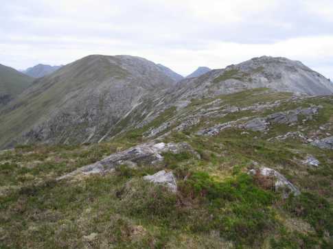
Western Arderin of the north Bens, with great views.
Summary created by simon3, Colin Murphy
2022-05-29 10:19:26
Picture: Landscape, seascape...
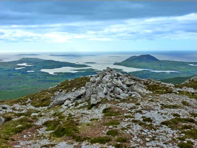
See comments for Bencullagh regarding route. From Bencullagh proceed NW for about 600m. The terrain is a mixture of grass and rock and firm underfoot. There is an easy 50m ascent from the col to the summit, which is marked by a cairn and affords spectacular views of the western seaboard.
This hill receives faint praise because it's just crossed in transit, into or out of the Pins. Well it's a fine hill in its own right but if you're heading out where are you going? I've seen two suggestions and neither are appealing. The route to the radio mast road looks messy and what in god's name are you going to do if your lift's not there? Equally going out to Kylemore doesn't tempt and you arrive at Kylemore, surely Ireland's least attractive rip-off and not a beer in sight and your lift forgotten. I've dismissed the idea that you'd walk in and out of either of these and still have some energy left for a walk in between.
Looking for a circuit last week that wasn't just Glencoaghan, we got a lift to the road by Benglenisky and then circled via Binn Gabhar and Binn Bhan back to Maumonght. Beautiful weather, and only saw one other walker a hill away, paradise. From the last summit the north west ridge descends towards the edge of an area of woodland. From there the trip descends beyond anticlimax. Following the wood round north then west, I'd guess you're normally wallowing through wetlands. It had been a long dry spell so we were merely stumbling through dry grassy hummocks. At the west corner of the wood the National Park fence crosses a bridge (more of a concreted pipe, really.) Cross it and the fence (why don't they have occasional stiles?) Go WNW about three penitential kilometres paralleling about 300 metres north of the fence. We were out of water and this was definitely Ice Cold in Alex. Join the National Park track and gratefully walk out.
You're now at the crux of the route. The pub. You can have a couple of pints and decide to call your lift, or a taxi, or get wellied and stay in the pub which advertises beds at 15 Euros. The route 's no better than the two alternatives but the result's a lot better. And it's only moments until the last three miles are forgotten and the magic of the Pins reasserts itself. Linkback: mountainviews.ie/summit/269/comment/2670/
Read Less
Read More
simon3 on Maumonght
by simon3
11 Oct 2003
Maumonght is not so likely to be a target of choice for many walkers, more a place visited at the beginning or end of a walk. It’s a typical 12 Bens peak. Quartzite with little bog or vegetation growing on it. Starting places to reach it include the car park at Kylemore Abbey or A (L744 513), the start of a track through a forest that can lead you to a point south of Bencullagh (An Chailleach). Maybe someone more familiar with this part of the Bens could say whether its straightforward to get to Maumonght from the vicinity of Cregg Hill.
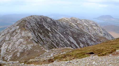
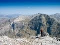
The picture shows Maumonght from An Chailleach (Bencullagh). In the background, to the right, is the Renvyle Peninsula with Tully Mountain sticking up from it. Above one of the bumps on Maumonght (the third from the left) is, faintly near the horizon, Inishbofin Island. Linkback: mountainviews.ie/summit/269/comment/708/
Read Less
Read More
simon3 on Maumonght
by simon3
11 Oct 2003
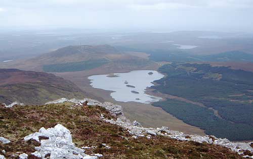
Maumonght has great views westwards, which is not surprising since it is the most westerly of the 12 Bens group (over 500m anyway).
The picture was taken on a somewhat fuzzy day, nevertheless it shows many features of interest. The lake below is Lough Nahillion. Just beyond it, to the left, is Cregg Hill (297m) with a substantial mast on it (only just visible in the pic). In line with the mast is Clifden and beyond it - Slyne Head.
In line with the right (north) edge of Lough Nahillion across some forest are Lough Auna (nearer) and Lough Shanakeever. Locals have reported seeing strange humped monsters in both of these lakes. There's even a website about it, so it must be true. Linkback: mountainviews.ie/summit/269/comment/710/
Read Less
Read More
Picture: View of Maumonght on way down
robhoward on Maumonght
by robhoward
19 Jun 2006
Started this from (B (L735 515)) and went up via Tievebaun hill (C (L733 529)). Needed to negotiate the odd fence but otherwise OK. Went up the ridge via the 454m point at (D (L744 534)) to the summit at (E (L749 540)). Good view to the west. Returned via the rivers to the footpath in the forest (F (L755 519)) and hence onto the road Linkback: mountainviews.ie/summit/269/comment/2410/
Use of MountainViews is governed by conditions and a privacy policy.
Read general information about the site. Opinions in material here are not necessarily endorsed by MountainViews.
Hillwalking is a risk sport. Information in comments, walks, shared GPS tracks or about starting places may
not be accurate for example as regards safety or access permission. You are responsible for your safety and your permission to walk.
See the credits and list definitions.


 Our Facebook page.