This website uses cookies, which are small text files that the website puts on your device to facilitate operation. Cookies help us provide a better service to you. They are used to track general user traffic information and to help the website function properly.
Feature count in area: 94, all in Cork,
OSI/LPS Maps: 78, 79, 80, 81, 83, 84, 85, 86, 87, 88
Highest Place: Great Island 95m
Starting Places (50) in area Cork Islands: Ahakista Pier, Allihies, Ardgroom, Bere Island Pier, Cahergal, Caherkeen, Canshanavoe South, Carr Clós Dún Óir, Castletownbere Lifeboat Harbour, Clashduff River Farm, Coolieragh Harbour Road, Coomadayallig Lake Road N, Coomadayallig Lake Road S, Coomhola Bridge, Coosanisky, Crosshaven Car Park, Derreenataggart Stone Circle Road, Dunboy Wood, Durrus Village, Dursey Cable Car Station, Eskakininaun, Eyeries, Firkeel, Garinish Car Park, Garinish Island Pier, Glenbeg Lough N, Glengarriff, Glengarriff Nature Reserve CP, Higher O'Connell Street, Ilnacullin Car Park, Kilcrohane, Knockacullin Lane, Leahill Bog, Leitrim Beg Standing Stone, Letter Cillin CP, Magannagan Stream, Mount Corrin Road, Nora's Cottage, Old Copper Road, Old Head of Kinsale, Owgarriff River Lane, Peg's Shop, Pooleen Wood Car Park, Reenroe Bridge, Rossmackowen Bridge, Rossmackowen Cemetery, Scilly Walk, Sherkin Island Pier, Sui Finn Car Park, Toberbanaha
Summits & other features in area Cork Islands: Adam's Island 29m, Aghillaun 5m, Ardillaun (2) 5m, Ballycotton island 50m, Bark Island 5m, Black Rock Islands 5m, Blue Islands 5m, Bridaun 15m, Bridaun Beg 15m, Bullaun Rock 15m, Bullock Island 42m, Calf Island East 22m, Calf Island Middle 14m, Calf Island West 28m, Capel Island 41m, Carbery Island 5m, Carrigdangin 15m, Carthy's Islands 14m, Castle Island (2) 5m, Castle Island (1) 36m, Chapel Island (3) 10m, Cold Island 5m, Coney Island (3) 12m, Dinish Island 12m, Eve's Island 8m, Eyeries Island 5m, Fastnet Rock 24m, Furze Island 15m, Garinish Island (2) 20m, Garinish Island (3) 15m, Garinish West 16m, Garvillaun 5m, Gerane East 5m, Goat Island Beg 21m, Goat Island Mór 33m, Great Island 95m, Hare Island (2) 26m, Haulbowline Island 20m, High Island (2) 45m, Hog Island (3) 5m, Horse Island (8) 39m, Horse Island (7) 5m, Horse Island (9) 36m, Horse Island (6) 5m, Illanebeg 25m, Illaunacuiree 5m, Illaunbweeheen 5m, Illaunglass East 5m, Illaunglass West 5m, Illaunnameanla 5m, Illaunrahnee 5m, Inishfarnard 44m, Kedge Island 36m, Lamb's Island (2) 20m, Long Island (2) 15m, Long Island (3) 31m, Loughure Island 5m, Lousy Castle Island 5m, Low Island 5m, Mannin Beg 5m, Mannin Island 18m, Mannions Island Large 5m, Mannions Island Small 5m, Minane Island 5m, Murphy's island 7m, Orthan's Island 5m, Owen's Island 6m, Pointabulloge Island 5m, Rabbit Island (2) 5m, Rabbit Island (3) 25m, Rabbit Island East 25m, Reenmore Island 5m, Roancarraigbeg 1m, Roancarrigmore 6m, Rocky Island 5m, Sandy Cove Island 30m, Sandy Island 5m, Sheelane Island 5m, Skeam East 19m, Skeam West 15m, Skiddy Island 5m, Small Island 15m, Sovereign Island East 15m, Sovereign Islands 30m, Spanish Island (2) 34m, Spike Island 24m, Stack Of Beans 25m, The Bull Rock 93m, The Calf 21m, The Catalogues 12m, The Cow 66m, The Stags of Toe Head 5m, Turk Island 5m, Whiddy Island 50m
Note: this list of places may include island features such as summits, but not
islands as such.
Rocky Island, 5mIsland Oileán Cathail A name in Irish,
Place Rating ..
, Cork County in Munster province, in Irish Islands Lists Reachable "On Foot " Y Grid Reference W79252 65002,
OS 1:50k mapsheet 85 Place visited by: 15members, recently by: Pizzagirl, chelman7, Fergalh, dregish, osullivanm, simon3, Glanman2, Pepe, sammullangalvin, tommccarthy, Dbosonnet, CaminoPat, DavidWalsh, corkrats, jackill, Island visited by 20 members.
I visited this place: NO (You need to be a logged-in member for this.)
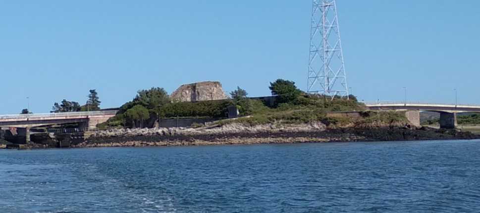
The road from Ringaskiddy to the naval base at Haulbowline crosses Rocky Island. If visiting, bear in mind that Rocky Island is no ordinary island: it is the site of the Cork crematorium. The crematorium and attendant parking facilities take up the bulk of the surface area. The problem for island peak-baggers is that the high point is so adjacent to the crematorium it juts up like a miniature mountain towering over the manmade facilities. Try not to coincide your climb with the arrival of a funeral party – a mourner might take the notion that it’s disrespectful or perhaps offensive to show off rock-climbing skills in such a sensitive location.
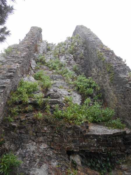
The miniature mountain mentioned above consists of a rock formation topped off with the remains of a manmade wall (there are engravings and paintings of Cork harbour which show that, several centuries ago, Rocky Island was conical. Much of the island was flattened by the British who turned it into a magazine facility - however they left this central chunk intact, leaving us a true island 'summit').
Attaining the high point involves a twelve or fifteen metre scramble. The least difficult approch is via the south face of the rock. It’s steep but there are plenty of hand and footholds as you admire the roof of the crematorium – to your left as you ascend. You do need to concentrate and have a good head for heights, especially on the descent. A fall would do a lot of damage. With luck you’ll be up and down in less than two minutes in a classic Spiderman imitation done all the quicker because of the surreal, furtive, uncomfortable ambience of the location. Then you could claim to be among the first to achieve this controversial ascent, solo and without aids, of the difficult South Face of Rocky Island! Linkback: mountainviews.ie/island/2496/comment/20644/
Read Less
Read More
Picture: The rock summit of Rocky Island can be seen rising high above the flat-topped crematorium
North face conquered and no acclimitisation needed
by Fergalh
24 Sep 2023
As it was a wet and windy day i took the North face ascent which was sheltered from the wind. At the pedestrian entrance steps to the crematorium I hopped the fence and zig -zaged briefly through the undergrowth to the rockface. Than the epic climb of 30 or so seconds started. A bit slippy with the rain but fine views on the summit. The crematorium usually opens only monday to friday and occasionally saturday so a weekend climb should not interrupt any funerals. Linkback: mountainviews.ie/island/2496/comment/24047/
Use of MountainViews is governed by conditions and a privacy policy.
Read general information about the site. Opinions in material here are not necessarily endorsed by MountainViews.
Hillwalking is a risk sport. Information in comments, walks, shared GPS tracks or about starting places may
not be accurate for example as regards safety or access permission. You are responsible for your safety and your permission to walk.
See the credits and list definitions.


 Our Facebook page.