This website uses cookies, which are small text files that the website puts on your device to facilitate operation. Cookies help us provide a better service to you. They are used to track general user traffic information and to help the website function properly.
Feature count in area: 65, all in Kerry,
OSI/LPS Maps: 78, 83, 84, 85, EW-KNP, EW-R
Highest Place: Stumpa Dúloigh 784m
Starting Places (66) in area Dunkerron Mountains: Ballaghasheen Coilte, Ballaghasheen Pass Viewpoint, Ballaghbeama Gap, Bohacullia, Bridia Valley End, Cahersavane Road, Cahersavane Schoolhouse, Cloon Lough NE, Cloon Lough SE, Coad Cemetery, Coad Road End, Com an Chiste, Coomaclarig Bridge, Coomnahorna River, Coomyanna Bridge, Dereenavurrig, Derreendarragh Church, Derrynane Quay, Dunkerron Mid, Eagles Lough Access Trailhead, Esknaloughoge Forest Trailhead, Fermoyle Farm, Foot Stick Ford Road, Gap of Dunloe Head of, Glashaknockbrassel Stream, Glasheenoultagh Stream, Gortaclohane Lane End, Gortaclohane Lane NE Branch, Gortagowan Wood, Gowlane School Ruin, Gowlanes Wood, Graces Landing, Inchimore West, Isknagahinney Lough E, Kenmare Bridge, Knockanamadane, Knockanaskill N, Knocknasullig, Knocknsallagh Bridge, Laghtacallow, Lissatinnig Bridge Boreen, Looscaunagh Lough W, Lough Barfinnihy CP, Lough Brin S, Lough Coomeen SE, Lough Dromtine NE, Lough Dromtine SE, Lough Fada N, Lough Iskanamacteery N, Lough Iskanamacteery NW, Lough Reagh N, Maghanlawaun Bridia Valley, Molls Gap, Ochtiabh Road, Poulacapple, River Owroe Source, River Sneem Fermoyle Loop, Rossacoosane Mid, Sahaleen Bridge, Scarriff Island, Shamrock Farmhouse B&B, Sneem, Tooreenboy Lough, Tooreennafersha Mid, Tooreennafersha South, Waterville Promenade
Summits & other features in area Dunkerron Mountains: Knocknagantee Near West Top 628m Cen: An Bheann Mhór: An Bheann Mhór 674.7m, An Bhinn Láir 514m, Coomcallee 648.9m, Beann na Stiocairí 673.1m, Coomnahorna 590m, Glanbeg 485.8m, Slievenashaska 578m, Slievenashaska South Top 565.4m Cen: Knocknagantee: Knockmoyle 682.1m, Finnararagh 667m, Cnoc Breasail 591m, Knocknagantee 674.3m, Knocknagantee West Top 553m, Coomnacronia 636m, Coomura Mountain 666m Cen: Mullaghanattin: An Cnoc Riabhach 534m, Beann 752m, Beann Far SW Top 636.2m, Beann NE Top 692m, Beann South Top 639m, Beann SW Top 657m, Sallagh 570m, Mullaghanattin 773m, Mullaghanattin East Top 594m, Sallagh South-West Top 543m E: Kenmare: Gortamullin 205m, Knockanaskill 356m, Letter South 362m N: Knocknacusha: Knocknacusha 547m NE: Knocknabreeda Ridge: Crossderry 489m, Knocknabreeda 569m, Mothaillín 506m NE: Knocknagapple: Bascadh 595m, Bascadh West Top 569m, Boughil 631m, Cnoc na gCapall 639m, Knocklomena 641m NE: Stumpa Dúloigh: Broaghnabinnia 745m, Knockaunanattin 569m, Knockaunanattin West Top 466.1m, Stumpa Dúloigh 784m, Stumpa Dúloigh SE Top 780m, Stumpa Dúloigh SW Top 663m SW: Caherdaniel: Farraniaragh Mountain 468m, Eagle Hill 155m, Reenearagh 162m, Beenarourke 304m, Knocknasullig 117m, Cahernageeha Mountain 498.7m SW: Coad ( Castle Cove ): Beenrour 418m, Eagles Hill 549m, Mullaghbeg 509m SW: Coomduff: Coomduff 244m SW: Deenish: Deenish Island (2) 144m SW: Esknaloughoge: Esknaloughoge 416m, Esknaloughoge North Top 420m SW: Scarriff: Scarriff Island 252m SW: Sneem: An Bheann Mhór 309.3m, Dereenavurrig Hill 261m, Knockanamadane 270m, Knocknafreaghane 316.5m, Knocknagullion 413m SW: Staigue: Staigue Top 459m, Staigue NE Top 435m
Note: this list of places may include island features such as summits, but not
islands as such.
Coomnacronia, 636mMountain Com na Cróine A name in Irish,
Place Rating ..
(Ir. Com na Cróine, 'hollow of the red cow'), Kerry County in Munster province, in Arderin, Vandeleur-Lynam Lists, Coomnacronia is the 229th highest place in Ireland.
Grid Reference V67993 73341,
OS 1:50k mapsheet 78 Place visited by: 122members, recently by: rhw, Djouce, knightsonhikes, maoris, daitho9, abcd, ToughSoles, Krzysztof_K, bryanmccabe, bagoff, NualaB, Beti13, Ianhhill, chelman7, Jai-mckinney
I visited this place: NO (You need to be a logged-in member for this.)
Longitude: -9.91851, Latitude: 51.897035, Easting: 67993, Northing: 73341,
Prominence: 71m, Isolation: 1.2km ITM: 467968 573393 Bedrock type: Green sandstone & siltstone, (St. Finans Sandstone Formation) Notes on name: This peak is situated between the valleys containing Eagles Lough and Lough Coomnacronia. Note that there is another valley called Coomnacronia in the Glenbeigh Horseshoe.
Short or GPS IDs, 6 char: Cmncrn, 10 char: Cmncrn Linkback: https://mountainviews.ie/summit/220/
Gallery for Coomnacronia (Com na Cróine) and surrounds
Summary
for Coomnacronia (Com na Cróine):
Overshadowed rounded scarp top.
Summary created by simon3
2011-07-04 10:51:53
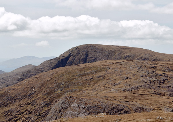
Picture: Coomnacronia beneath Knocknagantee on the skyline.
This summit is one section of the dramatic and continuous part of the Dunkerrons, stretching almost in a straight line from Mullaghanattin to An Bhinn Láir above Cloonaghlin Lough. It forms one of the four corners of an unusual high plateau also bounded by Knocknagantee, Knockmoyle and Coomura.
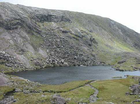
It will often be reached from one of its neighbouring summits, however if you wish to get there directly, you can possibly start on the track leading off the public road at Fermoyle F (V69259 71239). Ask permission at the house there. The track (it's the west of two shown leading from Fermoyle) has a stony surface until you reach the Small River where it turns into a quad trail, eventually ending near Lough Coomnacronia. Branch off the track and reach the top over steep but passable ground.
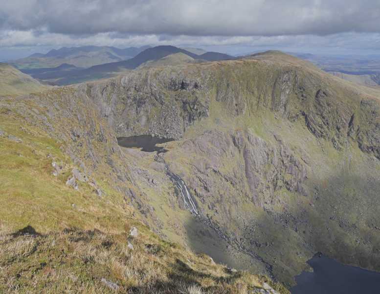
By swinging left you will get an outstanding view of Knocknagantee,
There's a great view of Coomnacronia from near the top of Knocknagantee. The upper lake is Lough Coomanassig and the lower is Eagle's Rock. In the background in shadow is Mullaghanattin.
The purple of the sandstone is very clear in this picture. Linkback: mountainviews.ie/summit/220/comment/24070/
Use of MountainViews is governed by conditions and a privacy policy.
Read general information about the site. Opinions in material here are not necessarily endorsed by MountainViews.
Hillwalking is a risk sport. Information in comments, walks, shared GPS tracks or about starting places may
not be accurate for example as regards safety or access permission. You are responsible for your safety and your permission to walk.
See the credits and list definitions.


 Our Facebook page.