This website uses cookies, which are small text files that the website puts on your device to facilitate operation. Cookies help us provide a better service to you. They are used to track general user traffic information and to help the website function properly.
MacGillycuddy's ReeksArea, Cen: Reeks West
Subarea
Feature count in area: 29, all in Kerry,
OSI/LPS Maps: 78, EW-KNP, EW-R
Highest Place: Carrauntoohil 1038.6m
Starting Places (19) in area MacGillycuddy's Reeks: Ballaghbeama Gap, Bridia Valley End, Cronins Yard, Gap of Dunloe Head of, Gap of Dunloe Kate K, Glashaknockbrassel Stream, Glasheenoultagh Stream, Hydro Road CP, Knocknsallagh Bridge, Lisleibane Trail Head, Lough Acoose North, Lough Acoose West, Lough Cappanlea OEC, Lough Caragh SW, Lough Fada N, Lough Reagh N, Maghanlawaun Bridia Valley, Shamrock Farmhouse B&B, Tomies Lough Leane NW
Summits & other features in area MacGillycuddy's Reeks: Cen: Reeks West: Beenkeragh 1008.2m, Caher 1000m, Caher West Top 973.4m, Carrauntoohil 1038.6m, Cnoc Íochtair 746.3m, Hag's Tooth 662m, Knockbrinnea East Top 845.4m, Knockbrinnea West Top 852.2m, The Bones Peak 956.5m, Skregmore 847.7m, Stumpa Bharr na hAbhann 852.1m E: Cnoc an Bhráca: Cnoc an Bhráca 728m, Cnoc na dTarbh 655m, Strickeen 440m N: Reeks North: Knockbrack 425m, Knocknabrone Hill 353m, Skregbeg 573m NW: Gortnagan: Gortnagan Beg 298m SE: Reeks East: Brassel Mountain 575m, Cnoc an Chuillinn 954.6m, Cnoc an Chuillinn East Top 922.9m, Knocknapeasta 985.1m, Cnoc na Toinne 844.1m, Cruach Mhór 930.8m, Maolán Buí 968.9m, The Big Gun 939.9m SW: Bridia: Beann Bhán 459.5m, Beendarrig 449.7m, Beann Dubh 450.5m
Note: this list of places may include island features such as summits, but not
islands as such.
Skregmore, 847.7mMountain Screig Mhór A name in Irish,
Place Rating ..
(Ir. Screig Mhór [OSI], 'big rocky outcrop'), Kerry County in Munster province, in Arderin, Vandeleur-Lynam Lists, Skregmore is the 20th highest place in Ireland.
Grid Reference V79213 86034,
OS 1:50k mapsheet 78 Place visited by: 480members, recently by: eimirmaguire, kieran117, kelleher, rhw, PiotrR, maoris, Carolineswalsh, knightsonhikes, ToughSoles, muddypaws, Kaszmirek78, Lyner, Iamcan, Moirabourke, Cunn2000
I visited this place: NO (You need to be a logged-in member for this.)
Longitude: -9.76, Latitude: 52.01369, Easting: 79213, Northing: 86034,
Prominence: 50.1m, Isolation: 0.5km ITM: 479189 586093 Bedrock type: Purple sandstone & siltstone, (Ballinskelligs Sandstone Formation) Notes on name: Ir. screig is a variant of creag/creig, 'a crag' (Ó Donaill, Foclóir Gaeilge-Béarla).
Short or GPS IDs, 6 char: Skrgmr, 10 char: Skregmore Linkback: https://mountainviews.ie/summit/21/
Gallery for Skregmore (Screig Mhór) and surrounds
Summary
for Skregmore (Screig Mhór):
Incidental summit in the Reeks
Summary created by Peter Walker
2018-11-15 22:07:36
Picture: Skregmore (middle) from Carrauntoohil
Much climbed but little remembered, Skregmore is a victim of its location. One of the highest summits in Ireland but adjacent to still higher tops, impressively rocky but still far less dramatic than many nearby mountains, it sits on the north arm of the Coomloughra Horseshoe, and its ascent will invariably be made either in the course of this marvellous outing or during an ascent/descent of Beenkeragh alone.
Start from the new car park at (A (V771 871)) and walk up the Hydro Road to Lough Eighter, then take to the steep slopes of Cnoc Íochtair; a path can be found leading most of the way up this. Once over this lesser summit a straightforward climb over grass, rock and boulders leads to the rough summit. The Coomloughra Horseshoe route continues over the slightly higher twin top of Stumpa Barr na hAbhann on the way to Beenkeragh.
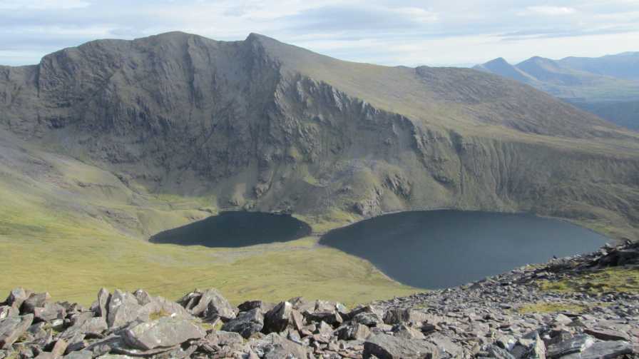
Skregmore is a very fine viewpoint, with the north face of Caher across the coum looking especially impressive.
Picture: Skregmore (with Cnoc Iochtair behind) from Stumpa Bharr na h-Abhann
eflanaga on Skregmore
by eflanaga
18 Jul 2006
From Stuaic Bharr na h-Abhann IB (V79631 85858) (see for previous stage of walk) you have a short but steep drop over very loose rocky ground to a saddle before ascending over similar ground to the summit of Skregmore. Perhaps, it was tiredness on my part but I found the ground to be particularly treacherous over this stage, almost turning my ankle on two or three occasions. Skregmore IC (V79211 86035) has, like most of the other summits in this are a small stone cairn marking its top. The views from here are akin to those from ‘Stuaic’. The weather had cleared considerably by this stage allowing for clearer views to the WNW across Loch Acoose and Carragh Lake and beyond as well as to the Brandon Group of mountains across the Bay. Linkback: mountainviews.ie/summit/21/comment/2436/
Read Less
Read More
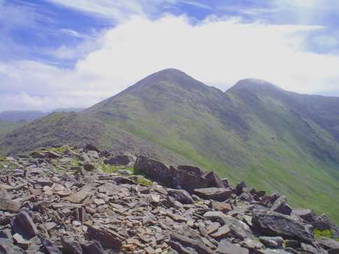
Picture: Looking S towards Caher and its W Top from the top of Skregmore.
Not the worst views of the Reeks !!
by David-Guenot
25 Jan 2016
Despite being overshadowed by its big sisters, Skregmore has some great views to offer. Thought I should share this pic I took in May 2015, as I was walking the Coomloughra Horseshoe anticlockwise, under absolutely perfect weather conditions. One can even see Mullaghanattin and Beann to the right of the picture. Linkback: mountainviews.ie/summit/21/comment/18428/
Read Less
Read More
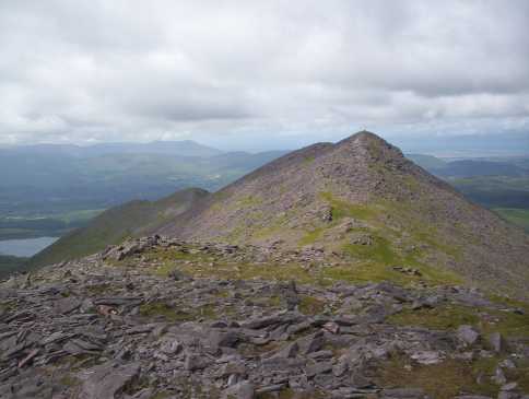
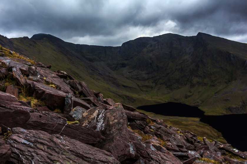
Picture: The Reeks from Skregmore
jackill on Skregmore
by jackill
18 Jul 2005
When you get to the summit of Skegmore this , if you're lucky , is the view that greets you.
The summit is strewn with rocks typical of much of the Reeks and there is a fair climb up from Cnoc Iarthair to reach Skregmore.The photo shows the way on to Stumpa Barr na hAbhann, Beenakeragh, Carrantoohils Tooth and Carrauntoohil. Linkback: mountainviews.ie/summit/21/comment/1815/
Read Less
Read More
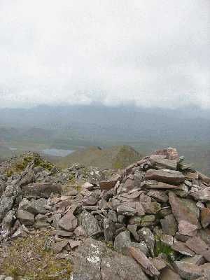
csd on Skregmore
by csd
20 May 2003
Skregmore is the first peak on the circuit of Coumloughra (assuming a clockwise direction). The picture shows the summit cairn looking back down west along the ridge. Linkback: mountainviews.ie/summit/21/comment/508/
Read Less
Read More
Picture: On The Way Up Skregmore
Struggling Against The Wind
by Aidy
27 Dec 2016
Second summit on a partially successful attempt at completing the Coomloughra Horseshoe. As on Cnoc Iochtair, the winds were fierce and I had to hunker down a few time during particularly bad gusts to avoid being blown off my feet. I didn't feel confident about finishing the horseshoe, but was taking every summit as a bonus. Linkback: mountainviews.ie/summit/21/comment/18736/
Use of MountainViews is governed by conditions and a privacy policy.
Read general information about the site. Opinions in material here are not necessarily endorsed by MountainViews.
Hillwalking is a risk sport. Information in comments, walks, shared GPS tracks or about starting places may
not be accurate for example as regards safety or access permission. You are responsible for your safety and your permission to walk.
See the credits and list definitions.


 Our Facebook page.