Cookies.
This website uses cookies, which are small text files that the website puts on your device to facilitate operation. Cookies help us provide a better service to you. They are used to track general user traffic information and to help the website function properly.
Features
Nearby features appear when you click the map.
Declutter tracks on map.
Place Search
Video
X
Pub: by
Wicklow Area , NE: Djouce Subarea
Feature count in area: 115, by county: Wicklow: 108, Kildare: 4, Wexford: 2, Carlow: 3, of which 1 is in both Wexford and Wicklow, of which 1 is in both Carlow and Wicklow, OSI/LPS Maps: 28B, 55, 56, 61, 62, AWW, EW-DM, EW-LG, EW-WE, EW-WS
Highest Place: Lugnaquilla 924.7m

Starting Places (205) in area Wicklow:
1916 Memorial Car Park, Aghavannagh Ow Bridge, Aghowle Wood, Altidore Wood Entrance, Annacurra National School, Annalecka Bridge, Asbawn Brook L8350, Aughrim National School, Ballard Road, Ballinabarny Gap, Ballinagappoge Bridge Layby, Ballinagappoge Mountain Hairpin, Ballinagore, Ballinahinch Wood, Ballinastoe MBT CP, Ballinastraw South, Ballineddan Upr Fork, Ballinfoyle Upr Cross, Ballycoog, Ballycreen Brook Bridge, Ballycumber, Ballycumber Bridge, Ballycumber Lane, Ballycumber Wicklow Way, Ballylerane, Ballylow Bridge, Ballylusk Quarry, Ballymanus Lane, Ballymoyle Shooting Lodge, Ballynultagh Gap, Ballynultagh Lane, Ballyreagh Wood, Ballyross Forest, Ballysmuttan Long Stone, Baravore, Barnbawn South, Barranisky North, Barranisky West, Bohilla Land Roundabout, Bohilla Lane Mid, Boranaraltry Bridge, Bray Harbour, Brewel West, Brittas Bay North CP, Buckroney Sand Dunes CP, Bus Terminus, Camera Hill Track Cross, Castletimon Wood North, Clara Vale, Clone House Road, Clonegal, Cloon Wood Cp, Coate Bridge, Coolballintaggart Ledge, Coolbawn House Lane, Cransillagh Brook , Crone Wood CP, Crossbridge, Crossoona Rath, Cummer Wood South, Curtlestown Wood CP, Deputy's Pass CP, Derralossary Church, Derry River Bridge, Devil's Glen CP, Devil's Glen Wood, Djouce Wood Calary, Djouce Wood Lake, Djouce Wood Long Hill, Donard, Donnelly's Lane Car Sales, Drumgoff Forest, Dunranhill North, Dunranhill SE, Dunranhill South, Dwyer McAllister Cottage CP, Enniskerry, Fentons Pub, Fitzsimons Park GAA, unuseableFlemings Footbridge Glen Rd, Gap Pub, Gap Road, Glen Beach CP, Glen of the Downs CP, Glenbride Lane, Glenbride Lodge, Glencree Reconciliation, Glendalough, Glenealy GAA, Glenmacnass Tonelagee CP, Glenmalure Hostel, Glenmalure Lodge, Glenmalure Waterfall, Glenview Hotel, Gowle House, Great Sugar Loaf CP, Grove Bar, Heffernans Well Wood, Hill View, Hollywood Glen, JB Malone CP, Johnnie Fox Pub, Keadeen NE trail, Keadeen Trailhead, Kevins Way Footbridge, Kilbride Army Camp Entrance, Kilcandra South, Kilcommon View, Killalongford Wood, Kilmacrea Cross Roads, Kilranelagh House Gate, Kilruddery Car Park, Kilruddery Cottages, Kings River, Kippure Bridge, Kippure Estate, Kippure Transmitter Gate, Knickeen Cross, Knocknaboley Lane Leeraghs Bog, Knocknaboley Lane Stone Cottage, Knockrath Little, Knockree west, Kyle Loop North, Lackan Wood S, Lake Dr Fraughan Brook, Lake Drive, Lake Park Cross, Lake View Pub, Laragh Free Car Park, Laragh NSch, Lead Mines CP, Liffey Bridge, Liffey Head Bridge, Lough Bray Lower, Lough Bray Upper, Lough Tay North Viewing Point, Lough Tay Wicklow Way CP, Luglass Lane L97561, Lugnagun Track, Macreddin Village, Mangans Lane, Military Road Carrigshouk Hill, Military Road Inchavore River Nth, Military Road Inchavore River Sth, Military Road NW Lough Tay, Military Road Ballyboy Bridge, Military Road Cloghoge Brook, Military Road Croaghanmoira, Military Road Fananierin, Military Road LaraghWicklow Way, Military Road Slieve Maan, Monspolien Bridge, Moortown House, Mountain Rescue HQ, Muskeagh Little Wood, Nahanagan Lough NE, Novara Avenue, Bray, Oiltiagh Brook Knickeen, Old Bridge Cross, Old Bridge Scouts , Old Wicklow Way entrance, Paddock Hill SE, Pier Gates CP, Powerscourt Waterfall CP, Putland Road, Quintagh East, Raheen Park CP, Raheenleagh East, Railway Walk CP, Rathdrum Railway Station, Rednagh Wood, Rocky Valley, Roundwood, Sally Gap, Sally Gap N, Seefin Trailhead, Seskin SE, Shankill Tributary Bridge, Shay Elliott, Sheepshanks Bridge, Shillelagh, Slievecorragh Track, Slievefoore South, Sraghoe Brook, St John's Church, St Kevins Chair, St Kevins Church, St Kevins Way R756, Stone Circle Bridge, Stookeen South, Stranahely Wood, Stranakelly Cross Roads, Tallyho, Templeboden, Tithewer, Tomcoyle L, Tomriland Wood, Toor Brook, Trooperstown Hill Access, Turlough Hill CP, Upper Lake CP, Vallymount GAA CP, Vartry Reservoir Upper, Zellers Pub

Summits & other features in area Wicklow:
Cen: Glendalough North: Brockagh Mountain 556.9m, Brockagh Mountain NW Top 549.5m, Brockagh Mountain SE Top 471.7m, Camaderry East Top 677.3m, Camaderry Mountain 698.6m, Conavalla 734m, Tomaneena 682.4m
Cen: Glendalough South: Carriglineen Mountain 456.6m, Cullentragh Mountain 510m, Derrybawn Mountain 476.1m, Kirikee Mountain 474.5m, Lugduff 653.2m, Lugduff SE Top 638m, Mullacor 660.7m, Trooperstown Hill 430m
N Cen: Tonelagee: Carrignagunneen 561m, Fair Mountain 571.2m, Stoney Top 713.7m, Tonelagee 815.8m, Tonelagee E Top 668m, Tonelagee South-East Top 545.8m
NE: Bray & Kilmacanogue: Bray Head Hill 238.9m, Carrigoona Commons East 242m, Downs Hill 372.9m, Great Sugar Loaf 501.2m, Little Sugar Loaf 342.4m
NE: Djouce: Djouce 725.5m, Knockree 342.1m, Maulin 570m, Tonduff 642m, Tonduff East Top 593m, War Hill 684.8m, White Hill 631.1m
NE: Fancy: Ballinafunshoge 480m, Kanturk 527.4m, Knocknacloghoge 532.4m, Luggala 593.3m, Robber's Pass Hill 508.9m, Scarr 640m, Scarr North-West Top 559.8m, Sleamaine 430m
NE: Vartry: Ballinacorbeg 336m, Ballycurry 301m, Dunranhill 342m, Mount Kennedy 365.9m
NW: Blessington: Carrigleitrim 408m, Lugnagun 446.2m, Slieveroe 332m, Sorrel Hill 599.5m
NW: Mullaghcleevaun: Black Hill 602.2m, Carrigshouk 572.5m, Carrigvore 682.4m, Duff Hill 720.8m, Gravale 719m, Moanbane 703m, Mullaghcleevaun 846.7m, Mullaghcleevaun East Top 796m, Silsean 698m
S: Aughrim Hills: Cushbawn 400m, Killeagh 249m, Moneyteige North 427m, Preban Hill 389m
S: Croaghanmoira: Ballinacor Mountain 529.3m, Ballycurragh Hill 536m, Ballyteige 447m, Carrickashane Mountain 508m, Croaghanmoira 662.3m, Croaghanmoira North Top 579.5m, Fananierin 426m, Slieve Maan 547.8m, Slieve Maan North Top 546.1m
S: Croghan Kinsella: Annagh Hill 454m, Croghan Kinsella 606m, Croghan Kinsella East Top 562.1m, Slievefoore 414m
S: Shillelagh Hills: Lakeen 357m, Monaughrim 206m, Seskin 344m, Stookeen 420m
S: Tinahely Hills: Ballycumber Hill 429.7m, Eagle Hill 296m, Muskeagh Hill 398.2m
SE: Wicklow South East: Ballinastraw 284m, Ballyguile Hill 188m, Barranisky 280m, Carrick Mountain 381m, Collon Hill 238m, Kilnamanagh Hill 217m, Westaston Hill 270m
W: Baltinglass: Ballyhook Hill 288m, Baltinglass Hill 382m, Carrig Mountain 571m, Carrigeen Hill 298m, Cloghnagaune 385m, Corballis Hill 258m, Keadeen Mountain 653m, Spinans Hill 409m, Spinans Hill SE Top 400m, Tinoran Hill 312m
W: Cen Lugnaquilla: Ballineddan Mountain 652.3m, Benleagh 689m, Camenabologue 758m, Camenabologue SE Top 663m, Cloghernagh 800m, Corrigasleggaun 794.6m, Lugnaquilla 924.7m, Slievemaan 759.7m
W: Donard: Brewel Hill 222m, Church Mountain 544m, Corriebracks 531m, Lobawn 636m, Slievecorragh 418m, Sugarloaf 552m, Table Mountain 701.7m, Table Mountain West Top 563m

Note: this list of places may include island features such as summits, but not islands as such.
Rating graphic.
Tonduff, 642m Mountain Tóin Dubh A name in Irish,
Place Rating ..
(Ir. Tóin Dubh [OSI*], 'black bottom'), Dougan's Hill, Wicklow County in Leinster province, in Arderin, Vandeleur-Lynam Lists, Tonduff is the 210th highest place in Ireland.
Grid Reference O15944 13685, OS 1:50k mapsheet 56
Place visited by: 653 members, recently by: rhw, MichaelButler, KateLeckie, Courin, MeabhTiernan, orlaithfitz, maoris, davidrenshaw, Prem, Carolineswalsh, Shaina, ToughSoles, muddypaws, Padraigin, SeanPurcell
I visited this place: NO (You need to be a logged-in member for this.)
Longitude: -6.267332, Latitude: 53.161294, Easting: 315944, Northing: 213685, Prominence: 117m,  Isolation: 1.2km
ITM: 715866 713713
Bedrock type: Granite with microcline phenocrysts, (Type 2p microcline porphyritic)
Notes on name: The marking of Tonduff North and Tonduff South as separate hill-names on the Discovery map does not seem justified, as there is only a single peak.
  Short or GPS IDs, 6 char: Tonduf, 10 char: Tonduff

Linkback: https://mountainviews.ie/summit/206/
Gallery for Tonduff (Tóin Dubh) and surrounds
Summary for Tonduff (Tóin Dubh): Flat, graceless top positioned for various routes.
Summary created by simon3 2011-02-28 15:12:27
            MountainViews.ie picture about Tonduff (<em>Tóin Dubh</em>)
Picture: Tonduff
While Tonduff is a flat boggy summit it is useful because it can be incorporated into various longer walks. It's east side and the east extending ridge it has towards Maulin are steep when facing north in places.
Two obvious approaches to Tonduff are from the east and the west respectively. From the west park in the Crone Wood carpark Crone Wd (O1920 1417) and walk on forest tracks to A (O181 141)from then up a shoulder SW to the summit.
From the west, start from the nearby R115 for example from Liffey Head Bridge at B (O137 137) from which it is around 2km over rough ground to the east.
Linkback: mountainviews.ie/summit/206/comment/4966/
Member Comments for Tonduff (Tóin Dubh)
Comment create / edit display placeholder

            MountainViews.ie picture about Tonduff (<em>Tóin Dubh</em>)
Picture: Moonrise over Tonduff.
Moonlight visit!
by Dessie1 18 Oct 2011
Parked car at Access road at base of Kippure Kipp Gt (O14139 14164) (Room for 4-5 cars here).Took a direct course bearing 106 deg toward summit across very wet,boggy and knee high heather filled terrrain(1.9Km). Reached open flat summit (C (O15944 13686)) after approx 45 mins which was marked by a mere gathering of stones atop some raised bog.Excellent views in all directions of War Hill,Djouce and Maulin to the South and Kippures mast to the NorthWest.Retraced steps back to car in a round trip of approx 1 and a half hrs. Linkback: mountainviews.ie/summit/206/comment/6586/
Read Less
Read More

Out in the Big Wide Open
by march-fixer 27 Feb 2012
Lovely lonely spot. Easily accessed from a number of directions. Not too many visitors. Most access seems to be by way of Maulin judging by the track erosion. Quite a bit of weather erosion at the summit. There is plenty shelter available.

The actual summit is in danger of collapsing ... eventually, whereupon it will need to be re-sited and re-calibrated! So if you are feeling energetic bring a rock with you and bolster this remaining bastion of summitness by building a retaining wall. One would end up with a possibly unique mountain feature of a peat summit. Linkback: mountainviews.ie/summit/206/comment/6700/
Read Less
Read More

Cormac_L on Tonduff
by Cormac_L 7 Jul 2008
Word of warning to those using the wall route, along the northern side of the Raven's Glen, to climb Tonduff. As you haul up by the path along the wall, about ten minutes up at a point where there's trees on both sides of the wall, a large, very nasty and very rusty piece of barbed wire has been draped over the wall itself. No big deal usually, except that this is a section where the path runs directly alongside the wall, and only gloves saved me from injuring my hand on it as I went up in wet conditions today.
Tried to pull the wire up and out but failed, next time I'm taking a small cutters. Linkback: mountainviews.ie/summit/206/comment/3208/
Read Less
Read More

            MountainViews.ie picture about Tonduff (<em>Tóin Dubh</em>)
padodes on Tonduff
by padodes 5 Jul 2008
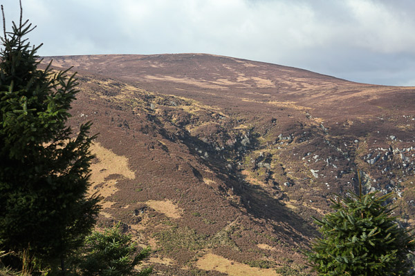
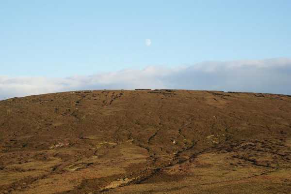
Tonduff is usually described as a dull, unexciting top, but a good approach can make amends for that, and the rugged Ravens’ Glen offers at least three of them. (Ravens’ Glen is the name given in the Harvey Map, though not in the OSI, to the little valley that some glacier chewed out of the eastern side of Tonduff. It lies within the square kilometre that has D (O170 130) as its lower left-hand corner.)

The first and easiest route starts just beyond where the forest track from Crone car park (Glencree) passes over the stream issuing from the glen. Crossing the stile to the left (A (O181 141)), one has only to follow the narrow track along the granite wall on the north side of the valley up to the shoulder at E (O175 142), before striking out slightly south-westwards, firstly over sharply rising ground and then over bogland, to nearby Tonduff.

Calling for a bit more exertion, a second approach begins on the south side of the glen, across a wet hollow that is accessed from the forest track at F (O180 136). At the head of the valley here, a clearly visible ramp and gully, usually with a negligible flow of water, leads upwards. Where it narrows at the top, the high vegetation closes in and tends to hamper but not prevent progress.

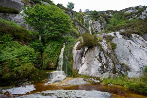
The third approach is the more challenging. Again, starting at the above-mentioned stile, one follows the ferny meanders of the stream that flows from the Glen, right up to the steep headwall. The photo shows this upper section, with its double waterfall. It is possible to push one’s way up onto the next level through the vegetation on the left-hand side, but just out of the picture, further to the right, the steep, smooth granite shelves down to within a manageable 6 ft of the ground. If you have a companion with you, a leg-up will get you started. If you haven’t, I found that throwing my rucksack onto the rock above, with my wallet inside, gave me all the incentive I needed to get over the obstacle. Once above, the climb continues over very broken ground, with rocky outcrops and thick vegetation but otherwise no insurmountable barrier. From the rim, the remainder of the way to Tonduff, directly west, is a 1 km walk over gently rising heathery ground. I don’t suppose this third approach to Tonduff, and maybe not even the second, will fall within every walker’s comfort zone, but if you’re in search of interesting alternatives and don’t mind roughing it a bit you won’t be disappointed. Linkback: mountainviews.ie/summit/206/comment/3203/
Read Less
Read More

            MountainViews.ie picture about Tonduff (<em>Tóin Dubh</em>)
simon3 on Tonduff
by simon3 23 Dec 2002
Tonduff is described on the OSI sheet 56 as being in two parts, Tonduff North and Tonduff South. Both have little visual appeal to the walker, though they are parts of various popular routes. The original name of Tonduff (black backside) adds little allure either. Geographically Tonduff is interesting because the sources of three East coast rivers start on the southern flanks of the mountain: the Liffey, Dargle and Avonmore.
The composite photo was taken during a circuit of the Glencree Valley in December and shows an unusual, carved rock to the east and south of the summit. Linkback: mountainviews.ie/summit/206/comment/248/
Read Less
Read More
EDIT Point of Interest
text
Videos


Users Online
jackos, Muscles1960, ToughSoles, learykid, Dee68, Haulie, eamonoc, therealcrow
Guests online: 235
Recent Contributions
x
Conditions and Info
Use of MountainViews is governed by conditions and a privacy policy.
Read general information about the site.
Opinions in material here are not necessarily endorsed by MountainViews.
Hillwalking is a risk sport. Information in comments, walks, shared GPS tracks or about starting places may not be accurate for example as regards safety or access permission. You are responsible for your safety and your permission to walk.
See the credits and list definitions.

OSi logo
OSNI/LPS logo
Open Street Map
(Various variations used.)
British summit data courtesy:
Database of British & Irish Hills