This website uses cookies, which are small text files that the website puts on your device to facilitate operation. Cookies help us provide a better service to you. They are used to track general user traffic information and to help the website function properly.
Feature count in area: 115, by county: Wicklow: 108, Kildare: 4, Wexford: 2, Carlow: 3, of which 1 is in both Wexford and Wicklow, of which 1 is in both Carlow and Wicklow,
OSI/LPS Maps: 28B, 55, 56, 61, 62, AWW, EW-DM, EW-LG, EW-WE, EW-WS
Highest Place: Lugnaquilla 924.7m
Starting Places (205) in area Wicklow: 1916 Memorial Car Park, Aghavannagh Ow Bridge, Aghowle Wood, Altidore Wood Entrance, Annacurra National School, Annalecka Bridge, Asbawn Brook L8350, Aughrim National School, Ballard Road, Ballinabarny Gap, Ballinagappoge Bridge Layby, Ballinagappoge Mountain Hairpin, Ballinagore, Ballinahinch Wood, Ballinastoe MBT CP, Ballinastraw South, Ballineddan Upr Fork, Ballinfoyle Upr Cross, Ballycoog, Ballycreen Brook Bridge, Ballycumber, Ballycumber Bridge, Ballycumber Lane, Ballycumber Wicklow Way, Ballylerane, Ballylow Bridge, Ballylusk Quarry, Ballymanus Lane, Ballymoyle Shooting Lodge, Ballynultagh Gap, Ballynultagh Lane, Ballyreagh Wood, Ballyross Forest, Ballysmuttan Long Stone, Baravore, Barnbawn South, Barranisky North, Barranisky West, Bohilla Land Roundabout, Bohilla Lane Mid, Boranaraltry Bridge, Bray Harbour, Brewel West, Brittas Bay North CP, Buckroney Sand Dunes CP, Bus Terminus, Camera Hill Track Cross, Castletimon Wood North, Clara Vale, Clone House Road, Clonegal, Cloon Wood Cp, Coate Bridge, Coolballintaggart Ledge, Coolbawn House Lane, Cransillagh Brook , Crone Wood CP, Crossbridge, Crossoona Rath, Cummer Wood South, Curtlestown Wood CP, Deputy's Pass CP, Derralossary Church, Derry River Bridge, Devil's Glen CP, Devil's Glen Wood, Djouce Wood Calary, Djouce Wood Lake, Djouce Wood Long Hill, Donard, Donnelly's Lane Car Sales, Drumgoff Forest, Dunranhill North, Dunranhill SE, Dunranhill South, Dwyer McAllister Cottage CP, Enniskerry, Fentons Pub, Fitzsimons Park GAA, unuseableFlemings Footbridge Glen Rd, Gap Pub, Gap Road, Glen Beach CP, Glen of the Downs CP, Glenbride Lane, Glenbride Lodge, Glencree Reconciliation, Glendalough, Glenealy GAA, Glenmacnass Tonelagee CP, Glenmalure Hostel, Glenmalure Lodge, Glenmalure Waterfall, Glenview Hotel, Gowle House, Great Sugar Loaf CP, Grove Bar, Heffernans Well Wood, Hill View, Hollywood Glen, JB Malone CP, Johnnie Fox Pub, Keadeen NE trail, Keadeen Trailhead, Kevins Way Footbridge, Kilbride Army Camp Entrance, Kilcandra South, Kilcommon View, Killalongford Wood, Kilmacrea Cross Roads, Kilranelagh House Gate, Kilruddery Car Park, Kilruddery Cottages, Kings River, Kippure Bridge, Kippure Estate, Kippure Transmitter Gate, Knickeen Cross, Knocknaboley Lane Leeraghs Bog, Knocknaboley Lane Stone Cottage, Knockrath Little, Knockree west, Kyle Loop North, Lackan Wood S, Lake Dr Fraughan Brook, Lake Drive, Lake Park Cross, Lake View Pub, Laragh Free Car Park, Laragh NSch, Lead Mines CP, Liffey Bridge, Liffey Head Bridge, Lough Bray Lower, Lough Bray Upper, Lough Tay North Viewing Point, Lough Tay Wicklow Way CP, Luglass Lane L97561, Lugnagun Track, Macreddin Village, Mangans Lane, Military Road Carrigshouk Hill, Military Road Inchavore River Nth, Military Road Inchavore River Sth, Military Road NW Lough Tay, Military Road Ballyboy Bridge, Military Road Cloghoge Brook, Military Road Croaghanmoira, Military Road Fananierin, Military Road LaraghWicklow Way, Military Road Slieve Maan, Monspolien Bridge, Moortown House, Mountain Rescue HQ, Muskeagh Little Wood, Nahanagan Lough NE, Novara Avenue, Bray, Oiltiagh Brook Knickeen, Old Bridge Cross, Old Bridge Scouts , Old Wicklow Way entrance, Paddock Hill SE, Pier Gates CP, Powerscourt Waterfall CP, Putland Road, Quintagh East, Raheen Park CP, Raheenleagh East, Railway Walk CP, Rathdrum Railway Station, Rednagh Wood, Rocky Valley, Roundwood, Sally Gap, Sally Gap N, Seefin Trailhead, Seskin SE, Shankill Tributary Bridge, Shay Elliott, Sheepshanks Bridge, Shillelagh, Slievecorragh Track, Slievefoore South, Sraghoe Brook, St John's Church, St Kevins Chair, St Kevins Church, St Kevins Way R756, Stone Circle Bridge, Stookeen South, Stranahely Wood, Stranakelly Cross Roads, Tallyho, Templeboden, Tithewer, Tomcoyle L, Tomriland Wood, Toor Brook, Trooperstown Hill Access, Turlough Hill CP, Upper Lake CP, Vallymount GAA CP, Vartry Reservoir Upper, Zellers Pub
Summits & other features in area Wicklow: Cen: Glendalough North: Brockagh Mountain 556.9m, Brockagh Mountain NW Top 549.5m, Brockagh Mountain SE Top 471.7m, Camaderry East Top 677.3m, Camaderry Mountain 698.6m, Conavalla 734m, Tomaneena 682.4m Cen: Glendalough South: Carriglineen Mountain 456.6m, Cullentragh Mountain 510m, Derrybawn Mountain 476.1m, Kirikee Mountain 474.5m, Lugduff 653.2m, Lugduff SE Top 638m, Mullacor 660.7m, Trooperstown Hill 430m N Cen: Tonelagee: Carrignagunneen 561m, Fair Mountain 571.2m, Stoney Top 713.7m, Tonelagee 815.8m, Tonelagee E Top 668m, Tonelagee South-East Top 545.8m NE: Bray & Kilmacanogue: Bray Head Hill 238.9m, Carrigoona Commons East 242m, Downs Hill 372.9m, Great Sugar Loaf 501.2m, Little Sugar Loaf 342.4m NE: Djouce: Djouce 725.5m, Knockree 342.1m, Maulin 570m, Tonduff 642m, Tonduff East Top 593m, War Hill 684.8m, White Hill 631.1m NE: Fancy: Ballinafunshoge 480m, Kanturk 527.4m, Knocknacloghoge 532.4m, Luggala 593.3m, Robber's Pass Hill 508.9m, Scarr 640m, Scarr North-West Top 559.8m, Sleamaine 430m NE: Vartry: Ballinacorbeg 336m, Ballycurry 301m, Dunranhill 342m, Mount Kennedy 365.9m NW: Blessington: Carrigleitrim 408m, Lugnagun 446.2m, Slieveroe 332m, Sorrel Hill 599.5m NW: Mullaghcleevaun: Black Hill 602.2m, Carrigshouk 572.5m, Carrigvore 682.4m, Duff Hill 720.8m, Gravale 719m, Moanbane 703m, Mullaghcleevaun 846.7m, Mullaghcleevaun East Top 796m, Silsean 698m S: Aughrim Hills: Cushbawn 400m, Killeagh 249m, Moneyteige North 427m, Preban Hill 389m S: Croaghanmoira: Ballinacor Mountain 529.3m, Ballycurragh Hill 536m, Ballyteige 447m, Carrickashane Mountain 508m, Croaghanmoira 662.3m, Croaghanmoira North Top 579.5m, Fananierin 426m, Slieve Maan 547.8m, Slieve Maan North Top 546.1m S: Croghan Kinsella: Annagh Hill 454m, Croghan Kinsella 606m, Croghan Kinsella East Top 562.1m, Slievefoore 414m S: Shillelagh Hills: Lakeen 357m, Monaughrim 206m, Seskin 344m, Stookeen 420m S: Tinahely Hills: Ballycumber Hill 429.7m, Eagle Hill 296m, Muskeagh Hill 398.2m SE: Wicklow South East: Ballinastraw 284m, Ballyguile Hill 188m, Barranisky 280m, Carrick Mountain 381m, Collon Hill 238m, Kilnamanagh Hill 217m, Westaston Hill 270m W: Baltinglass: Ballyhook Hill 288m, Baltinglass Hill 382m, Carrig Mountain 571m, Carrigeen Hill 298m, Cloghnagaune 385m, Corballis Hill 258m, Keadeen Mountain 653m, Spinans Hill 409m, Spinans Hill SE Top 400m, Tinoran Hill 312m W: Cen Lugnaquilla: Ballineddan Mountain 652.3m, Benleagh 689m, Camenabologue 758m, Camenabologue SE Top 663m, Cloghernagh 800m, Corrigasleggaun 794.6m, Lugnaquilla 924.7m, Slievemaan 759.7m W: Donard: Brewel Hill 222m, Church Mountain 544m, Corriebracks 531m, Lobawn 636m, Slievecorragh 418m, Sugarloaf 552m, Table Mountain 701.7m, Table Mountain West Top 563m
Note: this list of places may include island features such as summits, but not
islands as such.
Mullaghcleevaun, 846.7mMountain Mullach Cliabháin A name in Irish,
Place Rating ..
(Ir. Mullach Cliabháin [logainm.ie], 'summit of the cradle/basket'), Cleevaun, Wicklow County in Leinster province, in Arderin, Vandeleur-Lynam, Irish Highest Hundred Lists, Mullaghcleevaun is the second highest mountain in the Wicklow area and the 21st highest in Ireland. Mullaghcleevaun is the second highest point in county Wicklow.
Grid Reference O06762 07044,
OS 1:50k mapsheet 56 Place visited by: 940members, recently by: jackos, kelleher, rhw, andodenis, Sophie-Hayes, MartMc, Tommer504, Paddym99, garybuz, orlaithfitz, maoris, davidrenshaw, Lidia27, Magic, Prem
I visited this place: NO (You need to be a logged-in member for this.)
Longitude: -6.406732, Latitude: 53.103585, Easting: 306763, Northing: 207044,
Prominence: 374m, Isolation: 1.5km, Has trig pillar
ITM: 706688 707076 Bedrock type: Granite with microcline phenocrysts, (Type 2p microcline porphyritic) Notes on name: Joyce says it is named after a cradle-like depression near the top, presumably the one occupied by Cleevaun Lough.
Short or GPS IDs, 6 char: Mlghcl, 10 char: Mlghclvn Linkback: https://mountainviews.ie/summit/20/
Gallery for Mullaghcleevaun (Mullach Cliabháin) and surrounds
Summary
for Mullaghcleevaun (Mullach Cliabháin):
Bulky rounded summit which is the crux of many North Wicklow routes
Summary created by markmjcampion, simon3
2023-08-17 11:29:28
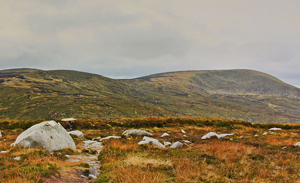
Picture: Mullaghcleevaun and corrie from the East
Mullaghcleevaun is a bulky mountain in NW Wicklow, just a few km E of Blessington Lakes. Commanding 360 degree views of the Wicklow uplands, its steep NE corrie is home to Cleevaun Lough. Navigational ability is a must in mist as the top is fairly featureless and there is dangerous ground to its NE.
NW. Mullaghcleevaun can be reached from the NW via Black Hill starting from BNulta Gp (O04384 10845). There is a good track initially but after Black Hill it can be quite boggy esp. after rain. (3.5h+ 12k round trip)
SE. Park near CShouk (O10271 05243) under Carrigshouk and, avoiding the very steep eastern side of Carrigshouk, head on a feint trail in a NW direction until you get to the ridge that connects M with Carrigshouk. It's a straightforward ridge walk after this although care should be taken in the mist as the path is not always well defined before East Top. (2h+ 9k round trip)
NE. Start at the Sally Gap [SalGp (O13028 10994)] and start by following directions for Carrigvore. It's a much walked route but tracks aren't always easy to find [3 to 4 hrs one way and over 12k]
E. Park at Inch N (O11313 07381) and follow directions to Duff Hill before joining the previous trail.
If linking M with Tonlegee beware that the Barnacullian ridge can be very soft - it's best to walk on the E side of this. Be aware that the Glenmacnass River may become impassable quickly in rain.
Short return tracks include track/2370 and track/1729
See track/2355 for a long loop and track/2293 for a long A to B.
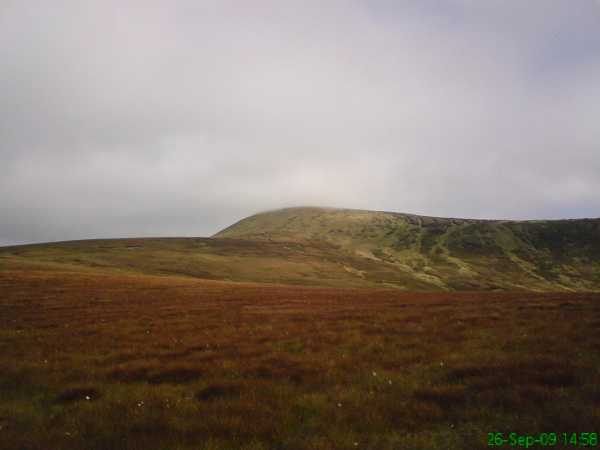
Picture: Lokking back at Mullaghcleevaun on route to Moanbane
pplsgod on Mullaghcleevaun
by pplsgod
10 Mar 2021
Climbed Mullaghcleevaun via Carrigshouk and the East Top on the 26th September 2009. Decided to traverse across from Carrigshouk to Ballyknockan. There is a nice pub called the Lakeview Lodge where I parked my car in the morning and got a lift back to the start point of Carrigshouk at A (O102 050)
The climb to Carrigshouk itself was relatively straightforward, the ground on the day was dry and made climbing a lot easier. From the summit I took a moment to get my bearings and then proceeded north-west to Mullaghcleevaun east top. The cloud had descended around me by the time I was nearly at the summit but thankfully the ground was easy to walk along.
For those of you who geocache there is one hidden not far from the east top summit so I spent a few minutes looking for this. From here I then went due west trying to avoid descending too much ground before heading to Mullaghcleevaun itself. Due to the thickness of the cloud at this time I was at the summit in no time as the hike over from the east top is relatively straightforward .
Mullaghcleevaun was busy on the day as I ran into a walking club on the summit so I didn't hang around too long, sadly due to the cloud cover the views were hidden on the day. From here headed down to Billy Byrne's gap before heading upto Moanbane summit. The clouds had dissipated at this point and the view of the reservoir by now was excellent.
Took the relative short walk across to Silsean which due to the broken nature of the ground took longer than anticipated. The route up and indeed most of the summit has been destroyed by quad bikes making the hike a tougher slog than it would normally have been. Be sure to take care if the weather is wet.
From here it is descent all the way to Ballyknockan. Its a long descent and I found it tough on the feet so take a little extra time. Refer to the Mullaghcleevaun traverse on the walks list of this site for more info. Overall start to finish took 4.5 hours and well worth a little preparation with a 2 car set up. Linkback: mountainviews.ie/summit/20/comment/4151/
Read Less
Read More
Geo on Mullaghcleevaun
by Geo
23 Mar 2009
The terminus of our Sunday walk on March 22 2009. Took about 3.5 hours from Sally Gap and 3 hours return by the same route. Ascending to the trig point from Mullaghcleevaun East, you will be glad to have favourable weather as you can pick your way upslope hard to the right to avoid the awfull peaty mud. If its misty and you have to follow a bearing its best stay on the bearing as going too far north to avoid the muck will bring you close to a bluff overlooking the corrie lake of Cleevaun Lough, which is a gorgeous little jewel set in the massive head of Mullaghcleevaun itself. A couple of memorials up here to look at as you wander around the summit trig point. Linkback: mountainviews.ie/summit/20/comment/3674/
Read Less
Read More
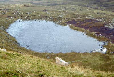
Picture: Cleevaun Lough frozen solid during our recent arctic weather
Mullaghcleevaun at 849 metres is the second highest mountain in Wicklow, after Lugnaquillia. Claude Wall said "[it].. commands the great plains to the north and west for an immense distance, the northern half of Leinster and the distant heights of Connaught and Ulster being visible on a clear day." On the north-east side of the summit, there is Cleevaun Lake. Often this is shrouded in mist, its wet surrounds making a cold place to rest before the steep ascent onto the summit. The day the picture was taken, at the end of an Indian Summer in Sept 2002, the clear view can be seen. Linkback: mountainviews.ie/summit/20/comment/149/
Read Less
Read More
Pádraig on Mullaghcleevaun
by Pádraig
13 Jun 2004
During the recent run of dry weather I climbed Mullaghcleevaun. Leaving the car in Gelnmacnass car park I walked up the Military road for some 2.5 miles to reach Carrigshouk. Having walked around this hill, you are given clear access to Mullaghcleevan East Top. Take some of the sheep paths through the heather and it will direct you on a hassel free approach. From East Top the gentle walk to the top of Mullaghcleevaun is straight forward (particularly in such dry weather). Once on the summit, it's nice to make a stop and maybe offer a prayer at the memorial for the An Oige members who died back in the fifties. On the descent I headed in the direction of Tonelagee (south). The stretch of land to Barnacullian is very unusual as there are great fissures in the bog resulting in a slow and time consuming trek. In some parts I came across crevasses that were nearly twenthy feet deep and fifteen feet wide. To stray into one of these would certainly give you a bit more than a sprained ankle. So, as you can imagine, there was a lot of doubling back and trying to find a different route. With a leap of imagination you could almost feel that you were trying to negotiate the Khumbu Icefall (or at least a boggy version of it). I'm sure this route could be somewhat dangerous in wet weather or in poor visibility. Anyway, once you hit Stoney Top, the pleasure of Tonelagee awaits. Linkback: mountainviews.ie/summit/20/comment/990/
Use of MountainViews is governed by conditions and a privacy policy.
Read general information about the site. Opinions in material here are not necessarily endorsed by MountainViews.
Hillwalking is a risk sport. Information in comments, walks, shared GPS tracks or about starting places may
not be accurate for example as regards safety or access permission. You are responsible for your safety and your permission to walk.
See the credits and list definitions.


 Our Facebook page.