Cookies.
This website uses cookies, which are small text files that the website puts on your device to facilitate operation. Cookies help us provide a better service to you. They are used to track general user traffic information and to help the website function properly.
Features
Nearby features appear when you click the map.
Declutter tracks on map.
Place Search
Video
X
Pub: by
Dunkerron Mountains Area , Cen: Knocknagantee Subarea
Feature count in area: 65, all in Kerry, OSI/LPS Maps: 78, 83, 84, 85, EW-KNP, EW-R
Highest Place: Stumpa Dúloigh 784m

Starting Places (66) in area Dunkerron Mountains:
Ballaghasheen Coilte, Ballaghasheen Pass Viewpoint, Ballaghbeama Gap, Bohacullia, Bridia Valley End, Cahersavane Road, Cahersavane Schoolhouse, Cloon Lough NE, Cloon Lough SE, Coad Cemetery, Coad Road End, Com an Chiste, Coomaclarig Bridge, Coomnahorna River, Coomyanna Bridge, Dereenavurrig, Derreendarragh Church, Derrynane Quay, Dunkerron Mid, Eagles Lough Access Trailhead, Esknaloughoge Forest Trailhead, Fermoyle Farm, Foot Stick Ford Road, Gap of Dunloe Head of, Glashaknockbrassel Stream, Glasheenoultagh Stream, Gortaclohane Lane End, Gortaclohane Lane NE Branch, Gortagowan Wood, Gowlane School Ruin, Gowlanes Wood, Graces Landing, Inchimore West, Isknagahinney Lough E, Kenmare Bridge, Knockanamadane, Knockanaskill N, Knocknasullig, Knocknsallagh Bridge, Laghtacallow, Lissatinnig Bridge Boreen, Looscaunagh Lough W, Lough Barfinnihy CP, Lough Brin S, Lough Coomeen SE, Lough Dromtine NE, Lough Dromtine SE, Lough Fada N, Lough Iskanamacteery N, Lough Iskanamacteery NW, Lough Reagh N, Maghanlawaun Bridia Valley, Molls Gap, Ochtiabh Road, Poulacapple, River Owroe Source, River Sneem Fermoyle Loop, Rossacoosane Mid, Sahaleen Bridge, Scarriff Island, Shamrock Farmhouse B&B, Sneem, Tooreenboy Lough, Tooreennafersha Mid, Tooreennafersha South, Waterville Promenade

Summits & other features in area Dunkerron Mountains:
Knocknagantee Near West Top 628m
Cen: An Bheann Mhór: An Bheann Mhór 674.7m, An Bhinn Láir 514m, Coomcallee 648.9m, Beann na Stiocairí 673.1m, Coomnahorna 590m, Glanbeg 485.8m, Slievenashaska 578m, Slievenashaska South Top 565.4m
Cen: Knocknagantee: Knockmoyle 682.1m, Finnararagh 667m, Cnoc Breasail 591m, Knocknagantee 674.3m, Knocknagantee West Top 553m, Coomnacronia 636m, Coomura Mountain 666m
Cen: Mullaghanattin: An Cnoc Riabhach 534m, Beann 752m, Beann Far SW Top 636.2m, Beann NE Top 692m, Beann South Top 639m, Beann SW Top 657m, Sallagh 570m, Mullaghanattin 773m, Mullaghanattin East Top 594m, Sallagh South-West Top 543m
E: Kenmare: Gortamullin 205m, Knockanaskill 356m, Letter South 362m
N: Knocknacusha: Knocknacusha 547m
NE: Knocknabreeda Ridge: Crossderry 489m, Knocknabreeda 569m, Mothaillín 506m
NE: Knocknagapple: Bascadh 595m, Bascadh West Top 569m, Boughil 631m, Cnoc na gCapall 639m, Knocklomena 641m
NE: Stumpa Dúloigh: Broaghnabinnia 745m, Knockaunanattin 569m, Knockaunanattin West Top 466.1m, Stumpa Dúloigh 784m, Stumpa Dúloigh SE Top 780m, Stumpa Dúloigh SW Top 663m
SW: Caherdaniel: Farraniaragh Mountain 468m, Eagle Hill 155m, Reenearagh 162m, Beenarourke 304m, Knocknasullig 117m, Cahernageeha Mountain 498.7m
SW: Coad ( Castle Cove ): Beenrour 418m, Eagles Hill 549m, Mullaghbeg 509m
SW: Coomduff: Coomduff 244m
SW: Deenish: Deenish Island (2) 144m
SW: Esknaloughoge: Esknaloughoge 416m, Esknaloughoge North Top 420m
SW: Scarriff: Scarriff Island 252m
SW: Sneem: An Bheann Mhór 309.3m, Dereenavurrig Hill 261m, Knockanamadane 270m, Knocknafreaghane 316.5m, Knocknagullion 413m
SW: Staigue: Staigue Top 459m, Staigue NE Top 435m

Note: this list of places may include island features such as summits, but not islands as such.
Rating graphic.
Finnararagh, 667m Mountain An Corrán A name in Irish,
Place Rating ..
(Ir. An Corrán [TH], 'the crescent' or 'the sickle'), Kerry County in Munster province, in Arderin, Vandeleur-Lynam, Irish Best Hundred, Irish Highest Hundred Lists, An Corrán is the 165th highest place in Ireland.
Grid Reference V69686 73720, OS 1:50k mapsheet 78
Place visited by: 138 members, recently by: rhw, Djouce, Nailer1967, knightsonhikes, maoris, abcd, ToughSoles, Krzysztof_K, bryanmccabe, NualaB, nupat, Beti13, chelman7, SeanPurcell, Barrington1978
I visited this place: NO (You need to be a logged-in member for this.)
Longitude: -9.893619, Latitude: 51.900755, Easting: 69686, Northing: 73720, Prominence: 142m,  Isolation: 0.9km
ITM: 469691 573761
Bedrock type: Green sandstone & siltstone, (St. Finans Sandstone Formation)
Notes on name: Finnararagh is a corruption of Finnavogagh, the name of an area of rough pasture on the plateau W of this peak. The name is correctly recorded in the Ordnance Survey Name Book, but was misspelt when transferred to the map. The peak itself is locally called An Corrán, which aptly describes its crescent-shaped cliffs that dominate Lough Coomeen.
  Short or GPS IDs, 6 char: Fnrrgh, 10 char: Finararagh

Linkback: https://mountainviews.ie/summit/160/
Gallery for Finnararagh (An Corrán) and surrounds
Summary for Finnararagh (An Corrán): Dramatic cliffs, bogs and rough ground surround this peak.
Summary created by markmjcampion, simon3 2021-03-19 21:10:57
            MountainViews.ie picture about Finnararagh (<em>An Corrán</em>)
Picture: The summit from the west.
There is dramatic ground all around the remote Finnararagh/An Corrán; however, the top is fairly tame and there are fairly easy ways up provided you are careful. It's on a wonderful multiday ridge walk from Waterville to the Ballaghbeama Gap. Attractions incl. the 310m cliffs down to Lough Coomeen to the E and fine views over the Kenmare River. There's a narrow challenging ridge NE towards Sallagh and on towards Mullaghanattin.

From the S and E the key to ascending is to get to the col at A (V69782 72254). This can be done by :
a) start at Fermoyle F (V69259 71239), asking permission at the house. The track (it's the W of two shown) has a stony surface as far as Small River. Follow the river and break off eventually to the aforementioned col. From here head NNE to B (V70219 73121) and then go NW to the summit. 90mins+
b) SE, start at Coomeen SE (V71137 72289) E - ample parking, walk back 50m to farm track, up to farm sheds keeping L in farm yard pass thru gate, turning R heading to rusted gate at C (V70294 72080) F - follow fence to the above col.
c) start at Coomyan Br (V71707 72935) I - only room for one car - there is a farm track not shown on OS78 that will bring you up close to the col.

N. Park by Cloon Lough at D (V70825 78784). Walk up to Coomura then round to Coomnacronia and up to the summit. Or you could head to Cloon NE (V70846 78403) and head steeply up to Beann NE Top and approach F via the northern ridge...see track/2604 for access issues here.

Notable tracks incl. track/3507, track/3622 and the epic track/2604
Linkback: mountainviews.ie/summit/160/comment/4920/
Member Comments for Finnararagh (An Corrán)
Comment create / edit display placeholder

            MountainViews.ie picture about Finnararagh (<em>An Corrán</em>)
Picture: Lakes on Finnararagh
Cloon Lough loop
by johnvbrennan 19 Mar 2021
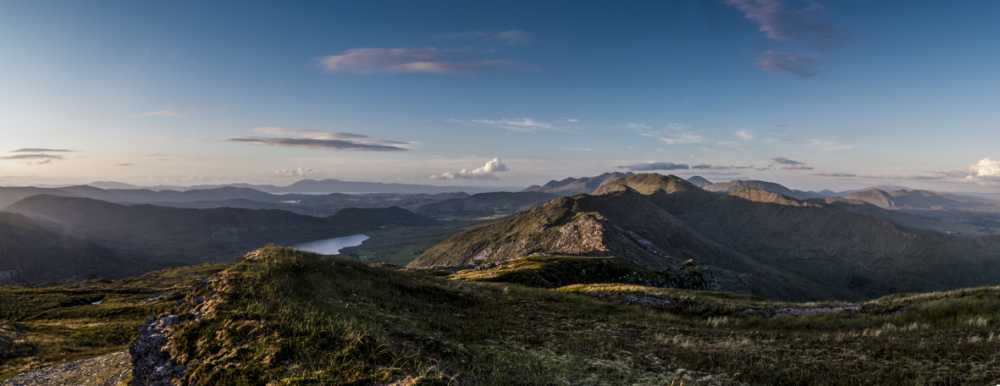
I highly recommend Finnararagh. It's not as climbed as the more popular mountains in Kerry like Carrauntuohill and Brandon. I would say this is mainly down to the fact that It's a good 45 minutes drive beyond Killarney. That said on a clear day it offers spectacular 360 degree views. You can see Brandon, Carrauntuohill/Caher and of course Mullaghanattin.

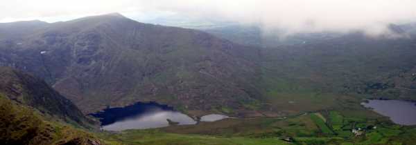
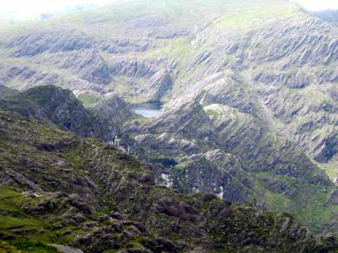
Finnararagh has some amazing lakes that are nestled into the mountain. Make sure you have a good summers day for this one as it's the only way to really appreciate the scenery. Unfortunately I didn't have my camera on the day with the sunny weather but hopefully the photo will give you some idea of how nice it can be.`

Getting There:

From Killarney, take the road for Glencar. Go past Glencar post office, turn left at Bealalaw Bridge. Park your car at Cloon Lough (approx. E (V70820 78785))

Description of walk:

Head up the track on the northwestern side of Cloon Lough.

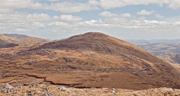
1 Make your way to the summit of Coomura mountain [666m above sea level]

2. Next make for the top of Coomnacronia via two cols to the couth of Coomura

3. Next ascend to spot Height 667m which is the summit of Finnararagh

4. Your now on the ridge at this point. Follow the ridge in a north easterly direction to spot height 543m to 570m to 551m to 619m . (Warning steep ridge at both sides from 543m on)

5. Turn east to spot height 636m heading for Mullaghanattin. Continue the ridge to 657m. Then drop down steeply (be vigilant here, steep ground that would be dangerous in foggy conditions) and climb sharply up to 752m (Beann). There is fence that runs all the way to the top of the mountain.

6. After 752m continue on the ridge for approx 1/3 km to meet the spur going down in a north westerly direction to join the road beside Cloon Lough. This road will bring you back to your car. Be careful coming down the spur as this ground is quite steep in places. Linkback: mountainviews.ie/summit/160/comment/1653/
Read Less
Read More

A Beautiful Ridge Walk
by sandman 30 Mar 2021
You have a choice of two starting points for this walk at Coomeen SE (V71137 72289) where there is ample parking. Park here and walk back 50 meters approx to farm track, up to farm sheds keeping left in farm yard pass through gate, turning right heading to rusted gate at C (V70294 72080) following fence to ridge and turning right at F (V69796 72271) follow this fence to G (V70223 73115) and turn left for summit.
Or you can start at Coomyan Br (V71707 72935), but be advised there is only room for one car - this is the easier option as there is a farm track not shown on OS78 that will bring you up close to point F (V69796 72271) - this option was only visible to me on my descent. - From summit of Finnararagh follow ridge across to Sallagh - Beann Far SW Top ( My 500th summit) and Beann SW Top after which you will begin your descent at H (V72074 74744) follow fence and river but bear in mind you are heading for farm track at I (V72107 75973) which will bring you down the valley to farm yard - very nice farmer - and back to car. The walk takes circa 5 hours with fantastic views over Cloon Lough and back towards Coomura Mountain. Linkback: mountainviews.ie/summit/160/comment/14738/
Read Less
Read More

            MountainViews.ie picture about Finnararagh (<em>An Corrán</em>)
Picture: Nestled Lakes
johnvbrennan on Finnararagh
by johnvbrennan 18 Apr 2005
Just had to add this photo of some unusual lakes on Finnararagh. The photo doesn't do them justice. Note: there are actually 2 lakes in the photo (spot the other one just beneath the main lake) Linkback: mountainviews.ie/summit/160/comment/1654/
Read Less
Read More

            MountainViews.ie picture about Finnararagh (<em>An Corrán</em>)
Picture: Exposed anticline W of Finnararagh.
Risen arches.
by simon3 26 Apr 2011
Striding along the scarp from Coomnacronia to An Corrán gives dramatic views to the south, however spare a thought for the geology visible also.
This arch in the rock (an anticline) is a sign of the huge folding pressures that must have been here once. Linkback: mountainviews.ie/summit/160/comment/6315/
Read Less
Read More

            MountainViews.ie picture about Finnararagh (<em>An Corrán</em>)
Picture: View from An Corrán on the Cloon Horseshoe walk
A Cloon View
by kernowclimber 5 Aug 2014
An Corrán lies on the Cloon Horseshoe walk in the wild and unspoilt Dunkerron Mountains which offer arguably some of the finest scenery in Ireland. This panorama was shot near its summit as the sun was sinking low in the western horizon. Macgillycuddy's Reeks can be seen in the background; the summits of Beann and Sallagh in the foreground; Cloon Lough and the Slieve Mish Mountains and Dingle Bay on the far left horizon. Linkback: mountainviews.ie/summit/160/comment/17595/
Read Less
Read More
EDIT Point of Interest
text
Videos


Users Online
jackos, Daingean, eamonoc, CaminoPat, Juanita
Guests online: 286
Recent Contributions
x
Conditions and Info
Use of MountainViews is governed by conditions and a privacy policy.
Read general information about the site.
Opinions in material here are not necessarily endorsed by MountainViews.
Hillwalking is a risk sport. Information in comments, walks, shared GPS tracks or about starting places may not be accurate for example as regards safety or access permission. You are responsible for your safety and your permission to walk.
See the credits and list definitions.

OSi logo
OSNI/LPS logo
Open Street Map
(Various variations used.)
British summit data courtesy:
Database of British & Irish Hills