This website uses cookies, which are small text files that the website puts on your device to facilitate operation. Cookies help us provide a better service to you. They are used to track general user traffic information and to help the website function properly.
Feature count in area: 115, by county: Wicklow: 108, Kildare: 4, Wexford: 2, Carlow: 3, of which 1 is in both Wexford and Wicklow, of which 1 is in both Carlow and Wicklow,
OSI/LPS Maps: 28B, 55, 56, 61, 62, AWW, EW-DM, EW-LG, EW-WE, EW-WS
Highest Place: Lugnaquilla 924.7m
Starting Places (205) in area Wicklow: 1916 Memorial Car Park, Aghavannagh Ow Bridge, Aghowle Wood, Altidore Wood Entrance, Annacurra National School, Annalecka Bridge, Asbawn Brook L8350, Aughrim National School, Ballard Road, Ballinabarny Gap, Ballinagappoge Bridge Layby, Ballinagappoge Mountain Hairpin, Ballinagore, Ballinahinch Wood, Ballinastoe MBT CP, Ballinastraw South, Ballineddan Upr Fork, Ballinfoyle Upr Cross, Ballycoog, Ballycreen Brook Bridge, Ballycumber, Ballycumber Bridge, Ballycumber Lane, Ballycumber Wicklow Way, Ballylerane, Ballylow Bridge, Ballylusk Quarry, Ballymanus Lane, Ballymoyle Shooting Lodge, Ballynultagh Gap, Ballynultagh Lane, Ballyreagh Wood, Ballyross Forest, Ballysmuttan Long Stone, Baravore, Barnbawn South, Barranisky North, Barranisky West, Bohilla Land Roundabout, Bohilla Lane Mid, Boranaraltry Bridge, Bray Harbour, Brewel West, Brittas Bay North CP, Buckroney Sand Dunes CP, Bus Terminus, Camera Hill Track Cross, Castletimon Wood North, Clara Vale, Clone House Road, Clonegal, Cloon Wood Cp, Coate Bridge, Coolballintaggart Ledge, Coolbawn House Lane, Cransillagh Brook , Crone Wood CP, Crossbridge, Crossoona Rath, Cummer Wood South, Curtlestown Wood CP, Deputy's Pass CP, Derralossary Church, Derry River Bridge, Devil's Glen CP, Devil's Glen Wood, Djouce Wood Calary, Djouce Wood Lake, Djouce Wood Long Hill, Donard, Donnelly's Lane Car Sales, Drumgoff Forest, Dunranhill North, Dunranhill SE, Dunranhill South, Dwyer McAllister Cottage CP, Enniskerry, Fentons Pub, Fitzsimons Park GAA, unuseableFlemings Footbridge Glen Rd, Gap Pub, Gap Road, Glen Beach CP, Glen of the Downs CP, Glenbride Lane, Glenbride Lodge, Glencree Reconciliation, Glendalough, Glenealy GAA, Glenmacnass Tonelagee CP, Glenmalure Hostel, Glenmalure Lodge, Glenmalure Waterfall, Glenview Hotel, Gowle House, Great Sugar Loaf CP, Grove Bar, Heffernans Well Wood, Hill View, Hollywood Glen, JB Malone CP, Johnnie Fox Pub, Keadeen NE trail, Keadeen Trailhead, Kevins Way Footbridge, Kilbride Army Camp Entrance, Kilcandra South, Kilcommon View, Killalongford Wood, Kilmacrea Cross Roads, Kilranelagh House Gate, Kilruddery Car Park, Kilruddery Cottages, Kings River, Kippure Bridge, Kippure Estate, Kippure Transmitter Gate, Knickeen Cross, Knocknaboley Lane Leeraghs Bog, Knocknaboley Lane Stone Cottage, Knockrath Little, Knockree west, Kyle Loop North, Lackan Wood S, Lake Dr Fraughan Brook, Lake Drive, Lake Park Cross, Lake View Pub, Laragh Free Car Park, Laragh NSch, Lead Mines CP, Liffey Bridge, Liffey Head Bridge, Lough Bray Lower, Lough Bray Upper, Lough Tay North Viewing Point, Lough Tay Wicklow Way CP, Luglass Lane L97561, Lugnagun Track, Macreddin Village, Mangans Lane, Military Road Carrigshouk Hill, Military Road Inchavore River Nth, Military Road Inchavore River Sth, Military Road NW Lough Tay, Military Road Ballyboy Bridge, Military Road Cloghoge Brook, Military Road Croaghanmoira, Military Road Fananierin, Military Road LaraghWicklow Way, Military Road Slieve Maan, Monspolien Bridge, Moortown House, Mountain Rescue HQ, Muskeagh Little Wood, Nahanagan Lough NE, Novara Avenue, Bray, Oiltiagh Brook Knickeen, Old Bridge Cross, Old Bridge Scouts , Old Wicklow Way entrance, Paddock Hill SE, Pier Gates CP, Powerscourt Waterfall CP, Putland Road, Quintagh East, Raheen Park CP, Raheenleagh East, Railway Walk CP, Rathdrum Railway Station, Rednagh Wood, Rocky Valley, Roundwood, Sally Gap, Sally Gap N, Seefin Trailhead, Seskin SE, Shankill Tributary Bridge, Shay Elliott, Sheepshanks Bridge, Shillelagh, Slievecorragh Track, Slievefoore South, Sraghoe Brook, St John's Church, St Kevins Chair, St Kevins Church, St Kevins Way R756, Stone Circle Bridge, Stookeen South, Stranahely Wood, Stranakelly Cross Roads, Tallyho, Templeboden, Tithewer, Tomcoyle Lower, Tomriland Wood, Toor Brook, Trooperstown Hill Access, Turlough Hill CP, Upper Lake CP, Vallymount GAA CP, Vartry Reservoir Upper, Zellers Pub
Summits & other features in area Wicklow: Cen: Glendalough North: Brockagh Mountain 556.9m, Brockagh Mountain NW Top 549.5m, Brockagh Mountain SE Top 471.7m, Camaderry East Top 677.3m, Camaderry Mountain 698.6m, Conavalla 734m, Tomaneena 682.4m Cen: Glendalough South: Carriglineen Mountain 456.6m, Cullentragh Mountain 510m, Derrybawn Mountain 476.1m, Kirikee Mountain 474.5m, Lugduff 653.2m, Lugduff SE Top 638m, Mullacor 660.7m, Trooperstown Hill 430m N Cen: Tonelagee: Carrignagunneen 561m, Fair Mountain 571.2m, Stoney Top 713.7m, Tonelagee 815.8m, Tonelagee E Top 668m, Tonelagee South-East Top 545.8m NE: Bray & Kilmacanogue: Bray Head Hill 238.9m, Carrigoona Commons East 242m, Downs Hill 372.9m, Great Sugar Loaf 501.2m, Little Sugar Loaf 342.4m NE: Djouce: Djouce 725.5m, Knockree 342.1m, Maulin 570m, Tonduff 642m, Tonduff East Top 593m, War Hill 684.8m, White Hill 631.1m NE: Fancy: Ballinafunshoge 480m, Kanturk 527.4m, Knocknacloghoge 532.4m, Luggala 593.3m, Robber's Pass Hill 508.9m, Scarr 640m, Scarr North-West Top 559.8m, Sleamaine 430m NE: Vartry: Ballinacorbeg 336m, Ballycurry 301m, Dunranhill 342m, Mount Kennedy 365.9m NW: Blessington: Carrigleitrim 408m, Lugnagun 446.2m, Slieveroe 332m, Sorrel Hill 599.5m NW: Mullaghcleevaun: Black Hill 602.2m, Carrigshouk 572.5m, Carrigvore 682.4m, Duff Hill 720.8m, Gravale 719m, Moanbane 703m, Mullaghcleevaun 846.7m, Mullaghcleevaun East Top 796m, Silsean 698m S: Aughrim Hills: Cushbawn 400m, Killeagh 249m, Moneyteige North 427m, Preban Hill 389m S: Croaghanmoira: Ballinacor Mountain 529.3m, Ballycurragh Hill 536m, Ballyteige 447m, Carrickashane Mountain 508m, Croaghanmoira 662.3m, Croaghanmoira North Top 579.5m, Fananierin 426m, Slieve Maan 547.8m, Slieve Maan North Top 546.1m S: Croghan Kinsella: Annagh Hill 454m, Croghan Kinsella 606m, Croghan Kinsella East Top 562.1m, Slievefoore 414m S: Shillelagh Hills: Lakeen 357m, Monaughrim 206m, Seskin 344m, Stookeen 420m S: Tinahely Hills: Ballycumber Hill 429.7m, Eagle Hill 296m, Muskeagh Hill 398.2m SE: Wicklow South East: Ballinastraw 284m, Ballyguile Hill 188m, Barranisky 280m, Carrick Mountain 381m, Collon Hill 238m, Kilnamanagh Hill 217m, Westaston Hill 270m W: Baltinglass: Ballyhook Hill 288m, Baltinglass Hill 382m, Carrig Mountain 571m, Carrigeen Hill 298m, Cloghnagaune 385m, Corballis Hill 258m, Keadeen Mountain 653m, Spinans Hill 409m, Spinans Hill SE Top 400m, Tinoran Hill 312m W: Cen Lugnaquilla: Ballineddan Mountain 652.3m, Benleagh 689m, Camenabologue 758m, Camenabologue SE Top 663m, Cloghernagh 800m, Corrigasleggaun 794.6m, Lugnaquilla 924.7m, Slievemaan 759.7m W: Donard: Brewel Hill 222m, Church Mountain 544m, Corriebracks 531m, Lobawn 636m, Slievecorragh 418m, Sugarloaf 552m, Table Mountain 701.7m, Table Mountain West Top 563m
Note: this list of places may include island features such as summits, but not
islands as such.
Downs Hill, 372.9mHill Altidore A name in English,
Place Rating ..
Downs Hill: OSI, Altidore: OSM, Wicklow County in Leinster province, in Local/Historical/Cultural Lists, Downs Hill is the 1013th highest place in Ireland.
Grid Reference O25307 10114,
OS 1:50k mapsheet 56 Place visited by: 52members, recently by: michaelseaver, NualaB, nupat, lauracardiff, Tommer504, Kaszmirek78, hak493r, Carolyn105, Dee68, megk971, Ansarlodge, arthurdoylephoto, childminder05, flynnke, JoHeaney
I visited this place: NO (You need to be a logged-in member for this.)
Short or GPS IDs, 6 char: DwnsHl, 10 char: Downs Hill Linkback: https://mountainviews.ie/summit/1513/
Gallery for Downs Hill (Altidore) and surrounds
Summary
for Downs Hill (Altidore):
Many ways up a low forested hill.
Summary created by simon3
2019-12-29 09:48:07
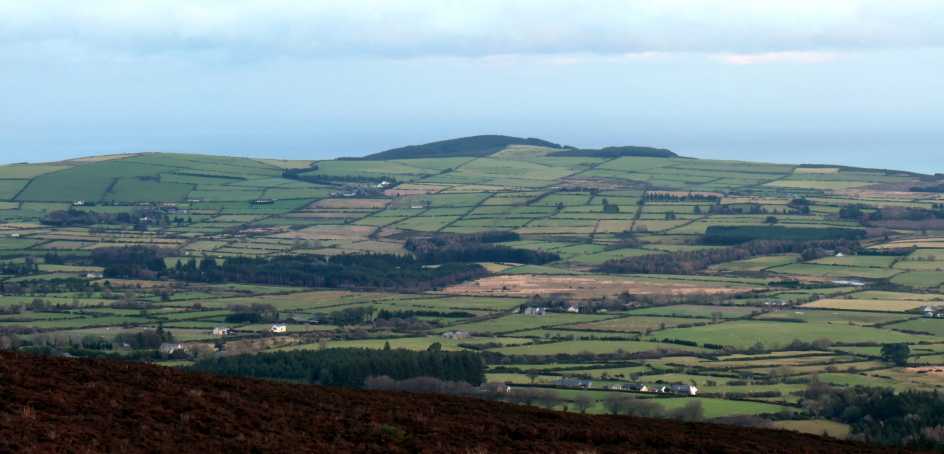
This a small hill great for a short walk and with some interesting views of coast and upland Wicklow.
One good starting point is A (O2600 1058) where a small path leaves the public road at a bend and heads into the woods. There is limited car parking here for 1 or at most 2 cars. Better parking can be found near the Grove Pub at around Grove (O2655 0959) which is also a great place for food and drink, though this does entail a walk of around 2k on the "Old Downs Road" to the previously mentioned forest access.
A south start is at B (O24147 08288) where there is very limited parking for at most 2 or 3 cars. It is not recommended to attempt to walk along the public road from the south start downhill to the east because it is a narrow dangerous public road. A west start is from C (O23425 09913) along a road past some houses and eventually into the forest. This route can be extremely muddy.
The land to the SW of the summit has been used for military purposes including a disused firing range.
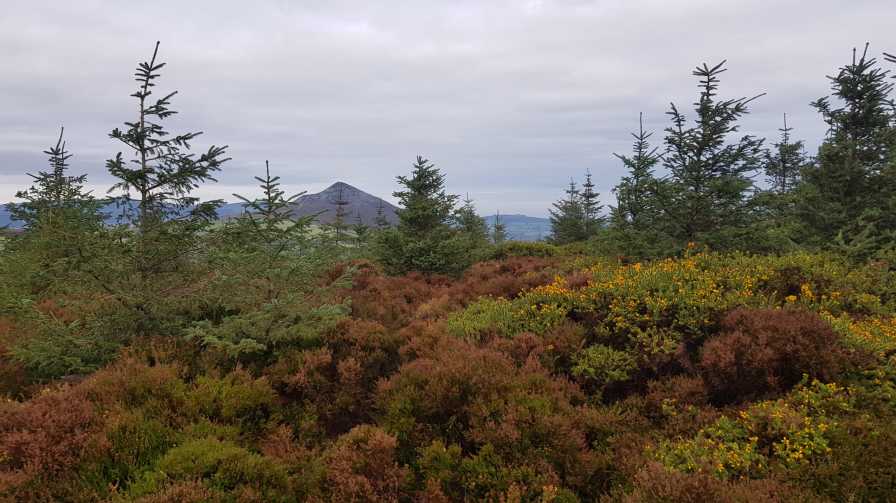
The summit of Downs Hill can be reached from the forest tracks over rough grounds There are occasional good views including of the Great Sugar Loaf.
Good Friday, showery weather, "Let's do one of the remaining easy ones in Local 100 " we thought. Didn't quite work out like that!
We would suggest that the start at A (O2600 1058) is no longer an option due to (understandable) parking signs / restrictions all along the lane. We started from the Grove Pub at Grove (O2655 0959) and strolled up the lane enjoying a sunny morning. Lovely views on the ascent forest track. As we reached the highest ground our thoughts turned to the summit. Initially we rounded the hill and descended slightly before trying to reach the summit from the south side. Problem! AVOID. We made 2 initial attempts to summit on "tracks" through gorse and failed. Our third was successful - luckily we were wearing our heaviest clothing and could push through bits of gorse. When we reached the summit we had a "so what" moment" with no views. Luckily we found a better descent track to the nearest forest track - and this is the section we have uploaded. We would advise using this section to ascend and descend the summit starting from D (O25453 10188). We have uploaded this section only as .gpx. We haven't uploaded the whole track since is is confusing due to our initial attempts and also because many of the tracks shown on EastWest have been disturbed by current harvesting of trees. Get out and do it before the gorse advances further. Linkback: mountainviews.ie/summit/1513/comment/24161/
Read Less
Read More
Picture: Old Downs a prickly top
Oh Deer a blessing in disguise
by eamonoc
25 Nov 2019
Visited Old Downs Hill Sunday, following track 4058 along good path for approx 3km to second switchback on trail through forest, on the left here a partially cleared area of woodland gives a view upwards to the large ringfort wall surrounding the top of the hill, at this point it is a distance of 200m to the top, went easily through mature woodland to the wall, now 160m from the top, crossed the wall and followed a well trodden but very rough narrow Deer path through the furze and discovered a small pile of stones indicating the top. Views restricted at top, get there soon before furze grows
and bars way of ascent . Linkback: mountainviews.ie/summit/1513/comment/20683/
Read Less
Read More
On yer Bike
by Pepe
22 May 2021
There are plenty of bike trails on Downs Hill now, which makes it possible to leave good forestry paths and head straight up, more or less, following ascending bike trails - keep an eye out for mountain bikes obviously. I only encountered two of them on this visit, from Point A upwards. On my way to A I asked a friendly local man for directions. He advised me to park at the Grove pub and walk up. "You'll be lucky to find a place to park up there," he said, "there are no parking signs, cones and lengths of red and white tape everywhere to prevent people parking on verges."
He was right, there was so much red and white I thought Cork had won yet another All-Ireland. I did manage to find a spot adjacent to (but not blocking!) a commercial premises. This was my fourth local 100 top of the day and in the knackered state I was in no way was this pair of legs willing to walk up and down from the Grove (which would add approx 3 kilometres to the walk). Parking seems to be a big issue hereabouts, so if you have the time (and not involved in a top-bagging odyssey), then making a good roadwalk out of it, before you tackle the trails, might be in order. Linkback: mountainviews.ie/summit/1513/comment/23154/
Use of MountainViews is governed by conditions and a privacy policy.
Read general information about the site. Opinions in material here are not necessarily endorsed by MountainViews.
Hillwalking is a risk sport. Information in comments, walks, shared GPS tracks or about starting places may
not be accurate for example as regards safety or access permission. You are responsible for your safety and your permission to walk.
See the credits and list definitions.


 Our Facebook page.