Cookies.
This website uses cookies, which are small text files that the website puts on your device to facilitate operation. Cookies help us provide a better service to you. They are used to track general user traffic information and to help the website function properly.
Features
Nearby features appear when you click the map.
Declutter tracks on map.
Place Search
Video
X
Pub: by
Wicklow Area , Cen: Glendalough North Subarea
Feature count in area: 115, by county: Wicklow: 108, Kildare: 4, Wexford: 2, Carlow: 3, of which 1 is in both Wexford and Wicklow, of which 1 is in both Carlow and Wicklow, OSI/LPS Maps: 28B, 55, 56, 61, 62, AWW, EW-DM, EW-LG, EW-WE, EW-WS
Highest Place: Lugnaquilla 924.7m

Starting Places (205) in area Wicklow:
1916 Memorial Car Park, Aghavannagh Ow Bridge, Aghowle Wood, Altidore Wood Entrance, Annacurra National School, Annalecka Bridge, Asbawn Brook L8350, Aughrim National School, Ballard Road, Ballinabarny Gap, Ballinagappoge Bridge Layby, Ballinagappoge Mountain Hairpin, Ballinagore, Ballinahinch Wood, Ballinastoe MBT CP, Ballinastraw South, Ballineddan Upr Fork, Ballinfoyle Upr Cross, Ballycoog, Ballycreen Brook Bridge, Ballycumber, Ballycumber Bridge, Ballycumber Lane, Ballycumber Wicklow Way, Ballylerane, Ballylow Bridge, Ballylusk Quarry, Ballymanus Lane, Ballymoyle Shooting Lodge, Ballynultagh Gap, Ballynultagh Lane, Ballyreagh Wood, Ballyross Forest, Ballysmuttan Long Stone, Baravore, Barnbawn South, Barranisky North, Barranisky West, Bohilla Land Roundabout, Bohilla Lane Mid, Boranaraltry Bridge, Bray Harbour, Brewel West, Brittas Bay North CP, Buckroney Sand Dunes CP, Bus Terminus, Camera Hill Track Cross, Castletimon Wood North, Clara Vale, Clone House Road, Clonegal, Cloon Wood Cp, Coate Bridge, Coolballintaggart Ledge, Coolbawn House Lane, Cransillagh Brook , Crone Wood CP, Crossbridge, Crossoona Rath, Cummer Wood South, Curtlestown Wood CP, Deputy's Pass CP, Derralossary Church, Derry River Bridge, Devil's Glen CP, Devil's Glen Wood, Djouce Wood Calary, Djouce Wood Lake, Djouce Wood Long Hill, Donard, Donnelly's Lane Car Sales, Drumgoff Forest, Dunranhill North, Dunranhill SE, Dunranhill South, Dwyer McAllister Cottage CP, Enniskerry, Fentons Pub, Fitzsimons Park GAA, unuseableFlemings Footbridge Glen Rd, Gap Pub, Gap Road, Glen Beach CP, Glen of the Downs CP, Glenbride Lane, Glenbride Lodge, Glencree Reconciliation, Glendalough, Glenealy GAA, Glenmacnass Tonelagee CP, Glenmalure Hostel, Glenmalure Lodge, Glenmalure Waterfall, Glenview Hotel, Gowle House, Great Sugar Loaf CP, Grove Bar, Heffernans Well Wood, Hill View, Hollywood Glen, JB Malone CP, Johnnie Fox Pub, Keadeen NE trail, Keadeen Trailhead, Kevins Way Footbridge, Kilbride Army Camp Entrance, Kilcandra South, Kilcommon View, Killalongford Wood, Kilmacrea Cross Roads, Kilranelagh House Gate, Kilruddery Car Park, Kilruddery Cottages, Kings River, Kippure Bridge, Kippure Estate, Kippure Transmitter Gate, Knickeen Cross, Knocknaboley Lane Leeraghs Bog, Knocknaboley Lane Stone Cottage, Knockrath Little, Knockree west, Kyle Loop North, Lackan Wood S, Lake Dr Fraughan Brook, Lake Drive, Lake Park Cross, Lake View Pub, Laragh Free Car Park, Laragh NSch, Lead Mines CP, Liffey Bridge, Liffey Head Bridge, Lough Bray Lower, Lough Bray Upper, Lough Tay North Viewing Point, Lough Tay Wicklow Way CP, Luglass Lane L97561, Lugnagun Track, Macreddin Village, Mangans Lane, Military Road Carrigshouk Hill, Military Road Inchavore River Nth, Military Road Inchavore River Sth, Military Road NW Lough Tay, Military Road Ballyboy Bridge, Military Road Cloghoge Brook, Military Road Croaghanmoira, Military Road Fananierin, Military Road LaraghWicklow Way, Military Road Slieve Maan, Monspolien Bridge, Moortown House, Mountain Rescue HQ, Muskeagh Little Wood, Nahanagan Lough NE, Novara Avenue, Bray, Oiltiagh Brook Knickeen, Old Bridge Cross, Old Bridge Scouts , Old Wicklow Way entrance, Paddock Hill SE, Pier Gates CP, Powerscourt Waterfall CP, Putland Road, Quintagh East, Raheen Park CP, Raheenleagh East, Railway Walk CP, Rathdrum Railway Station, Rednagh Wood, Rocky Valley, Roundwood, Sally Gap, Sally Gap N, Seefin Trailhead, Seskin SE, Shankill Tributary Bridge, Shay Elliott, Sheepshanks Bridge, Shillelagh, Slievecorragh Track, Slievefoore South, Sraghoe Brook, St John's Church, St Kevins Chair, St Kevins Church, St Kevins Way R756, Stone Circle Bridge, Stookeen South, Stranahely Wood, Stranakelly Cross Roads, Tallyho, Templeboden, Tithewer, Tomcoyle L, Tomriland Wood, Toor Brook, Trooperstown Hill Access, Turlough Hill CP, Upper Lake CP, Vallymount GAA CP, Vartry Reservoir Upper, Zellers Pub

Summits & other features in area Wicklow:
Cen: Glendalough North: Brockagh Mountain 556.9m, Brockagh Mountain NW Top 549.5m, Brockagh Mountain SE Top 471.7m, Camaderry East Top 677.3m, Camaderry Mountain 698.6m, Conavalla 734m, Tomaneena 682.4m
Cen: Glendalough South: Carriglineen Mountain 456.6m, Cullentragh Mountain 510m, Derrybawn Mountain 476.1m, Kirikee Mountain 474.5m, Lugduff 653.2m, Lugduff SE Top 638m, Mullacor 660.7m, Trooperstown Hill 430m
N Cen: Tonelagee: Carrignagunneen 561m, Fair Mountain 571.2m, Stoney Top 713.7m, Tonelagee 815.8m, Tonelagee E Top 668m, Tonelagee South-East Top 545.8m
NE: Bray & Kilmacanogue: Bray Head Hill 238.9m, Carrigoona Commons East 242m, Downs Hill 372.9m, Great Sugar Loaf 501.2m, Little Sugar Loaf 342.4m
NE: Djouce: Djouce 725.5m, Knockree 342.1m, Maulin 570m, Tonduff 642m, Tonduff East Top 593m, War Hill 684.8m, White Hill 631.1m
NE: Fancy: Ballinafunshoge 480m, Kanturk 527.4m, Knocknacloghoge 532.4m, Luggala 593.3m, Robber's Pass Hill 508.9m, Scarr 640m, Scarr North-West Top 559.8m, Sleamaine 430m
NE: Vartry: Ballinacorbeg 336m, Ballycurry 301m, Dunranhill 342m, Mount Kennedy 365.9m
NW: Blessington: Carrigleitrim 408m, Lugnagun 446.2m, Slieveroe 332m, Sorrel Hill 599.5m
NW: Mullaghcleevaun: Black Hill 602.2m, Carrigshouk 572.5m, Carrigvore 682.4m, Duff Hill 720.8m, Gravale 719m, Moanbane 703m, Mullaghcleevaun 846.7m, Mullaghcleevaun East Top 796m, Silsean 698m
S: Aughrim Hills: Cushbawn 400m, Killeagh 249m, Moneyteige North 427m, Preban Hill 389m
S: Croaghanmoira: Ballinacor Mountain 529.3m, Ballycurragh Hill 536m, Ballyteige 447m, Carrickashane Mountain 508m, Croaghanmoira 662.3m, Croaghanmoira North Top 579.5m, Fananierin 426m, Slieve Maan 547.8m, Slieve Maan North Top 546.1m
S: Croghan Kinsella: Annagh Hill 454m, Croghan Kinsella 606m, Croghan Kinsella East Top 562.1m, Slievefoore 414m
S: Shillelagh Hills: Lakeen 357m, Monaughrim 206m, Seskin 344m, Stookeen 420m
S: Tinahely Hills: Ballycumber Hill 429.7m, Eagle Hill 296m, Muskeagh Hill 398.2m
SE: Wicklow South East: Ballinastraw 284m, Ballyguile Hill 188m, Barranisky 280m, Carrick Mountain 381m, Collon Hill 238m, Kilnamanagh Hill 217m, Westaston Hill 270m
W: Baltinglass: Ballyhook Hill 288m, Baltinglass Hill 382m, Carrig Mountain 571m, Carrigeen Hill 298m, Cloghnagaune 385m, Corballis Hill 258m, Keadeen Mountain 653m, Spinans Hill 409m, Spinans Hill SE Top 400m, Tinoran Hill 312m
W: Cen Lugnaquilla: Ballineddan Mountain 652.3m, Benleagh 689m, Camenabologue 758m, Camenabologue SE Top 663m, Cloghernagh 800m, Corrigasleggaun 794.6m, Lugnaquilla 924.7m, Slievemaan 759.7m
W: Donard: Brewel Hill 222m, Church Mountain 544m, Corriebracks 531m, Lobawn 636m, Slievecorragh 418m, Sugarloaf 552m, Table Mountain 701.7m, Table Mountain West Top 563m

Note: this list of places may include island features such as summits, but not islands as such.
Rating graphic.
Camaderry Mountain, 698.6m Mountain Sliabh Cham an Doire A name in Irish,
Place Rating ..
(Ir. Céim an Doire [OSNB], 'step/pass of the oak-wood'), Comaderry, Wicklow County in Leinster province, in Arderin, Vandeleur-Lynam Lists, Camaderry Mountain is the 116th highest place in Ireland.
Grid Reference T08155 98084, OS 1:50k mapsheet 56
Place visited by: 905 members, recently by: Muscles1960, agakilbride, rhw, Tuigamala, jellybean, KateLeckie, MartMc, Hjonna, Courin, MeabhTiernan, taramatthews, orlaithfitz, maoris, davidrenshaw, Prem
I visited this place: NO (You need to be a logged-in member for this.)
Longitude: -6.388958, Latitude: 53.022824, Easting: 308155, Northing: 198084, Prominence: 71m,  Isolation: 1.1km
ITM: 708080 698118
Bedrock type: Adamellite with microcline phenocrysts, (Glendalough Adamellite)

  Short or GPS IDs, 6 char: CmdrMn, 10 char: CmdryMntn

Linkback: https://mountainviews.ie/summit/114/
Gallery for Camaderry Mountain (Sliabh Cham an Doire) and surrounds
Summary for Camaderry Mountain (Sliabh Cham an Doire): Valley views, pumped water and steep ascents.
Summary created by simon3 2013-05-31 08:49:27
            MountainViews.ie picture about Camaderry Mountain (<em>Sliabh Cham an Doire</em>)
Picture: Camaderry from the South.
Camaderry is a useful summit for starting or ending a walk around either the Glendalough or Glendasan valley, two of the five valleys radiating from Laragh. It has a boulder strewn summit from which there are views to much of the higher ground around central Wicklow. To its west is the upper reservoir of the Turlough Hill Pumped Water Storage facility used for generating electricity.

There's a number of ways to reach the top such as starting from the main, paying, carpark near the Glendalough lake at around UpCP (T1115 9635). Going straight up from here more or less north there is an extremely steep track up the glacially steepened valley wall to the SE ridge of Camaderry. Other ways of reaching this SE ridge are from the Glendasan valley A (T1157 9737), or by using tracks to reach B (T1175 9704).
You will find some badly damaged trails here.

Another way to start is from the Wicklow Gap car park TurL Hl (O0752 0009) from which you can walk up the track to the Turlough Hill lake or around the lower lake, L. Nahanagan and then up to Camaderry over steep but feasible heather.
Linkback: mountainviews.ie/summit/114/comment/4874/
Member Comments for Camaderry Mountain (Sliabh Cham an Doire)
Comment create / edit display placeholder

            MountainViews.ie picture about Camaderry Mountain (<em>Sliabh Cham an Doire</em>)
Picture: View of lower lake from Camaderry shoulder
wicklore on Camaderry Mountain
by wicklore 1 Aug 2008
Myself and Chefron headed up Camaderry via the Spink last Sunday. Starting at the carpark (C (T112 963)) we walked up past the Pollanass Waterfall. Glendalough was teeming with tourists on this beautiful day and a dozen languages could be heard around us.
Up past the waterfall, where the Wicklow Way turns left across a bridge, we turned right up the hairpin bend. A few minutes brought us to the start of the famous Spink Boardwalk on the right. This is about 2.5 km of boardwalk that heads up and along the cliffs on the southern side of the valley. It protects the delicate bog (already heavily eroded in places) while providing a clear route for occasional walkers and experienced hikers alike.
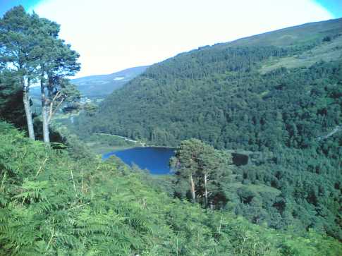
The boardwalk is tough going as it heads directly uphill through the forest. Endless steps wind upward but eventually the path levels off as it leaves the forest and fantastic views open up of the lake below and across to Camaderry and Turlough Hill.
The boardwalk continues along the line of the cliffs. There is a final hard slog up to the highest point where we met a couple who told us they had counted 1300 steps the previous week!
I always see the wild goats that live along these cliffs. However I observed some walkers who passed within 20 feet of the goats without spotting them-surely hiking should be a mix of tough exercise and leisurely sightseeing?
Beware that the boardwalk divides as one arm branches off towards Lugduff SE and Mullacor. Keep right at this junction.(approx D (T092 955))
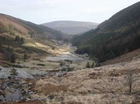
The boardwalk eventually runs out and a stone path leads down to a wooden bridge at approx E (T075 963). Most walkers then follow the track down to the Miners Village and the lake for the stroll back to the carpark. We headed N then NE towards the summit of Camaderry. It is a long haul across the bog. This is where the multitudes of the Spink Circuit are left behind and solitude is gained. I have rarely walked in Wicklow without spotting a few deer, and up here we were rewarded with a herd of more than a hundred scattered all across the slopes. They were surprisingly unfazed by us as we walked quite close to them.
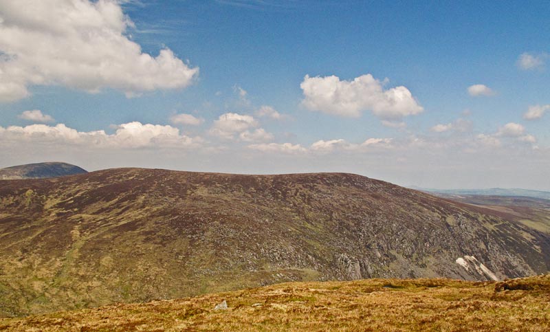
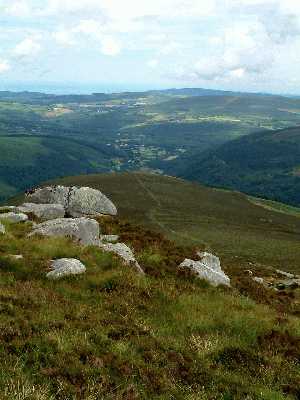
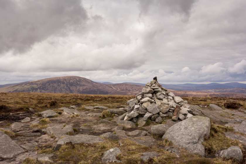
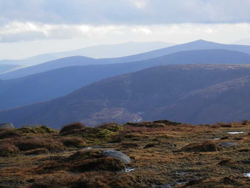
Camaderry was reached and we had a much needed rest. We had clear views SW across Lugduff to Fraughan Rock Glen, Lugnaquillia, and the surrounding mountains. In fact the views were great in all directions and I fancied I saw land far across the Irish Sea.
After a trip to Turlough Hill we came back and reached the second cairn on Camaderry at F (T089 973). Oliver kindly let us all know he had been here with his name scrawled on granite stone.
Heading E brought us down along the shoulder where we picked up a track going directly downhill at approx G (T108 970) towards the carpark. This becomes severely steep in places yet is a lovely walk through high ferns and forest. It’s wasn’t long before we rejoined the masses below and those who hadn’t even left the carpark turned to stare at these sweaty, smelly Mountain Men. Total time 6 hours. Linkback: mountainviews.ie/summit/114/comment/3252/
Read Less
Read More

            MountainViews.ie picture about Camaderry Mountain (<em>Sliabh Cham an Doire</em>)
Picture: Glendasan Valley Looking SE
dmg on Camaderry Mountain
by dmg 13 Mar 2009
Decided to bring the missus on a slightly more challenging trip than two rock mountain. We decided to climb lower summit of Camaderry. Set out from car park just after glendalough lodge(H (T124 969) Approx). From there we took a leisurely stroll down the road in a NW direction towards the upper lake you will see a right turn into picturesque Glendasan valley( I (T122 970) Approx), we took this. Following the signposted road and walkway(St. Kevins Rd.) up the valley NW towards the abandoned mines. Here we found a stone track with railway sleepers which is still on the signposted route. We kept on this track as far as the abandoned miners village(J (T098 983) Approx) where we took a sharp left in a SW direction through a track running over a spoil heap and up the side of the mountain. The ascent was steep and challenging in parts with some parts having to be climbed on hands and knees. Time to the cairn( F (T089 973) Approx) from carpark was approx 3 hours bearing in mind my partner is an inexperienced hiker. We had a much needed break at the top. We had great views of the surrounding valleys of Glendalough, Glendasan and Glenmalure and of course Lugnaquilla where there was still snow on the north prison. After a much needed sambo and water we began our descent. There is a track down the shoulder of camaderry from the lower cairn travellin in a SE direction. We followed this track, boggy in places but easygoing. Eventually coming into a pasture with some sparse trees where we saw a herd of deer. We followed the track to the right bringing us down to the car park at the upper lake in glendalough, this is very steep in places and takes a lot of time to descend safely this brings you into a forrest where the track is still steep and later gets easier dropping down on to the road at the upper lake car park( UpCP (T112 964) Approx), from here we took a left heading NE along the road back to glendalough lodge where we had parked the car. Trip was challenging and very enjoyable. The weather was mild for early March. Trip took 5 hours including 20 minutes break at the top, this was with an inexperienced hiker. An experienced hiker would have done it in 4 hours or less. Linkback: mountainviews.ie/summit/114/comment/3641/
Read Less
Read More

            MountainViews.ie picture about Camaderry Mountain (<em>Sliabh Cham an Doire</em>)
GWPR on Camaderry Mountain
by GWPR 30 Jul 2003
View along Camaderry as it drops down into Glendalough.
Start at the Car Park at Wicklow Gap and follow tarmac road up to Turlough Hill.
Keep rampart on left and follow it around to pick up track leading to Camaderry.
Note: Access not permitted inside rampart - ESB Property.
Boggy col before ascent to Camaderry but views from summit are excellent.
There is a distinct track leading to the second cairn before the descent to Glendalough.
From this second cairn the spur seems to fall into Glendalough!
Over to the right on a clear day one can see the dramatic Fraughan Rock Glen with Lug in the
distance. Nearer to the right are Mullacor and the Lugduffs. On the left are Tonelagee, Scarr and in the distance Djouce and War Hill. A lovely place on a clear Summer's day! Linkback: mountainviews.ie/summit/114/comment/589/
Read Less
Read More

            MountainViews.ie picture about Camaderry Mountain (<em>Sliabh Cham an Doire</em>)
Picture: The Summit of Camaderry SE Top
Great views from Camaderry
by jasonmac 24 Apr 2017
Parked at the Glendalough upper lake and paid the 4 euro, glad i did as this hike took me over 4 hours and the carpark was past closing by the time I got back. headed along the left side of lake and at the education centre took a sharp right then followed the path until a sharp left brought me uphill fairly steep at this point but nice walk along the grassy path. After short break thinking I was near the top I found as I've learned with Irish mountains, at the top of every hill, another summit appeared and so it went for another hour or so :)

The walk up and across the SE Top and the main summit of Camaderry was good underfoot with little bog or marsh, if the weather was better I may have stayed at the top longer to get some photos but it was overcast and darker than hoped. After short break some food and drink and feeling refreshed, coming down from the top toward Turlough hill reservoir is where the real challenge began trying to safely navigate the boggy marsh and avoid the holes in an effort to locate the Glenealo river and follow it to the Spinc trail.

Once i'd joined the Spinc trail heading down into Glendalough and the miners village the rock slabbed descent along the zig zag path was a killer on tired knees and made it slow going. In hindsight I wonder if travelling opposite direction would have been better. All in all a great few hours out. Linkback: mountainviews.ie/summit/114/comment/18899/
Read Less
Read More

            MountainViews.ie picture about Camaderry Mountain (<em>Sliabh Cham an Doire</em>)
Picture: Towards Camaderry
View from Tonlegee
by davsheen 2 May 2018
Camaderry from the summit of Tonlegee with Croghanmoira in the background Linkback: mountainviews.ie/summit/114/comment/19912/
Read Less
Read More
EDIT Point of Interest
text
Videos


Users Online
jackos, nupat, Muscles1960, madfrankie, Daingean, jimmel567, RangerBrian, lauracardiff, Alatar
Guests online: 251
Recent Contributions
x
Conditions and Info
Use of MountainViews is governed by conditions and a privacy policy.
Read general information about the site.
Opinions in material here are not necessarily endorsed by MountainViews.
Hillwalking is a risk sport. Information in comments, walks, shared GPS tracks or about starting places may not be accurate for example as regards safety or access permission. You are responsible for your safety and your permission to walk.
See the credits and list definitions.

OSi logo
OSNI/LPS logo
Open Street Map
(Various variations used.)
British summit data courtesy:
Database of British & Irish Hills