This website uses cookies, which are small text files that the website puts on your device to facilitate operation. Cookies help us provide a better service to you. They are used to track general user traffic information and to help the website function properly.
Feature count in area: 65, all in Kerry,
OSI/LPS Maps: 78, 83, 84, 85, EW-KNP, EW-R
Highest Place: Stumpa Dúloigh 784m
Starting Places (66) in area Dunkerron Mountains: Ballaghasheen Coilte, Ballaghasheen Pass Viewpoint, Ballaghbeama Gap, Bohacullia, Bridia Valley End, Cahersavane Road, Cahersavane Schoolhouse, Cloon Lough NE, Cloon Lough SE, Coad Cemetery, Coad Road End, Com an Chiste, Coomaclarig Bridge, Coomnahorna River, Coomyanna Bridge, Dereenavurrig, Derreendarragh Church, Derrynane Quay, Dunkerron Mid, Eagles Lough Access Trailhead, Esknaloughoge Forest Trailhead, Fermoyle Farm, Foot Stick Ford Road, Gap of Dunloe Head of, Glashaknockbrassel Stream, Glasheenoultagh Stream, Gortaclohane Lane End, Gortaclohane Lane NE Branch, Gortagowan Wood, Gowlane School Ruin, Gowlanes Wood, Graces Landing, Inchimore West, Isknagahinney Lough E, Kenmare Bridge, Knockanamadane, Knockanaskill N, Knocknasullig, Knocknsallagh Bridge, Laghtacallow, Lissatinnig Bridge Boreen, Looscaunagh Lough W, Lough Barfinnihy CP, Lough Brin S, Lough Coomeen SE, Lough Dromtine NE, Lough Dromtine SE, Lough Fada N, Lough Iskanamacteery N, Lough Iskanamacteery NW, Lough Reagh N, Maghanlawaun Bridia Valley, Molls Gap, Ochtiabh Road, Poulacapple, River Owroe Source, River Sneem Fermoyle Loop, Rossacoosane Mid, Sahaleen Bridge, Scarriff Island, Shamrock Farmhouse B&B, Sneem, Tooreenboy Lough, Tooreennafersha Mid, Tooreennafersha South, Waterville Promenade
Summits & other features in area Dunkerron Mountains: Knocknagantee Near West Top 628m Cen: An Bheann Mhór: An Bheann Mhór 674.7m, An Bhinn Láir 514m, Coomcallee 648.9m, Beann na Stiocairí 673.1m, Coomnahorna 590m, Glanbeg 485.8m, Slievenashaska 578m, Slievenashaska South Top 565.4m Cen: Knocknagantee: Knockmoyle 682.1m, Finnararagh 667m, Cnoc Breasail 591m, Knocknagantee 674.3m, Knocknagantee West Top 553m, Coomnacronia 636m, Coomura Mountain 666m Cen: Mullaghanattin: An Cnoc Riabhach 534m, Beann 752m, Beann Far SW Top 636.2m, Beann NE Top 692m, Beann South Top 639m, Beann SW Top 657m, Sallagh 570m, Mullaghanattin 773m, Mullaghanattin East Top 594m, Sallagh South-West Top 543m E: Kenmare: Gortamullin 205m, Knockanaskill 356m, Letter South 362m N: Knocknacusha: Knocknacusha 547m NE: Knocknabreeda Ridge: Crossderry 489m, Knocknabreeda 569m, Mothaillín 506m NE: Knocknagapple: Bascadh 595m, Bascadh West Top 569m, Boughil 631m, Cnoc na gCapall 639m, Knocklomena 641m NE: Stumpa Dúloigh: Broaghnabinnia 745m, Knockaunanattin 569m, Knockaunanattin West Top 466.1m, Stumpa Dúloigh 784m, Stumpa Dúloigh SE Top 780m, Stumpa Dúloigh SW Top 663m SW: Caherdaniel: Farraniaragh Mountain 468m, Eagle Hill 155m, Reenearagh 162m, Beenarourke 304m, Knocknasullig 117m, Cahernageeha Mountain 498.7m SW: Coad ( Castle Cove ): Beenrour 418m, Eagles Hill 549m, Mullaghbeg 509m SW: Coomduff: Coomduff 244m SW: Deenish: Deenish Island (2) 144m SW: Esknaloughoge: Esknaloughoge 416m, Esknaloughoge North Top 420m SW: Scarriff: Scarriff Island 252m SW: Sneem: An Bheann Mhór 309.3m, Dereenavurrig Hill 261m, Knockanamadane 270m, Knocknafreaghane 316.5m, Knocknagullion 413m SW: Staigue: Staigue Top 459m, Staigue NE Top 435m
Note: this list of places may include island features such as summits, but not
islands as such.
Beenarourke, 304mHill Binn Uí Ruairc A name in Irish,
Place Rating ..
Ir. Binn Uí Ruairc [logainm.ie], 'O'Rourke's peak', Kerry County in Munster province, in Binnion Lists, Binn Uí Ruairc is the 1153th highest place in Ireland.
Grid Reference V50200 60500,
OS 1:50k mapsheet 83 Place visited by: 21members, recently by: maoris, thomas_g, nickywood, daitho9, colmo23, MichaelE, Fergalh, eamonoc, markmjcampion, Eirepur, IainT, frankmc04, wicklore, chalky, trekker
I visited this place: NO (You need to be a logged-in member for this.)
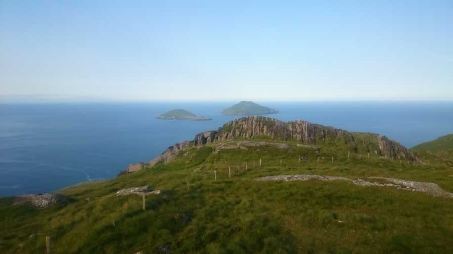
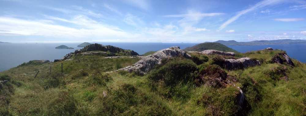
Beenarourke has two high points on its summit about 100 metres apart, which are similar in height. This photo was taken from the northerly summit looking to the rocky spine of the southerly summit. The best views are from the rocky spine, where Deenish and Scarriff Islands loom large in the expanse of the Atlantic ahead.
The views are fine across Ballinskelligs Bay to Bolus Head and out to the Skellig Islands. Abbey Island and the small Eagle Hill peninsula are to the southeast, while across the N70 below, the steep bulk of the Farraniaragh and Cahernageeha hills provides a dramatic backdrop to this area of the Ring of Kerry.
As madfrankie has said, this hill can be quickly climbed up from the substantial car park below, which will be teeming in high season. However the ground is steep and can be wet and slippery, and care will be needed going up and down. Wait for a clear day as the views are too good to miss! Linkback: mountainviews.ie/summit/1135/comment/18309/
Read Less
Read More
Picture: Where tourists fear to tread
A brief Ring of Kerry diversion
by madfrankie
28 Jul 2014
Beenarourke looms over the large car park at a bend in the road between Waterville and Caherdaniel. It can be a busy place in high summer, with swarms of tourists taking snaps, or looking in bafflement at the dishevelled local playing the accordion.
At the back of the car park head steeply uphill - you'll pick up a bit of a track. Within 15 minutes you'll be at the summit, admiring the superlative views that include the distant Skelligs. The highest point appears to be the low boulders seen in the photo. An undemanding little hill that won't take more than 25 minutes up and down. Linkback: mountainviews.ie/summit/1135/comment/17573/
Use of MountainViews is governed by conditions and a privacy policy.
Read general information about the site. Opinions in material here are not necessarily endorsed by MountainViews.
Hillwalking is a risk sport. Information in comments, walks, shared GPS tracks or about starting places may
not be accurate for example as regards safety or access permission. You are responsible for your safety and your permission to walk.
See the credits and list definitions.


 Our Facebook page.