This website uses cookies, which are small text files that the website puts on your device to facilitate operation. Cookies help us provide a better service to you. They are used to track general user traffic information and to help the website function properly.
Fermanagh & South TyroneArea, Cen: Tempo Hills
Subarea
Feature count in area: 15, by county: Fermanagh: 9, Tyrone: 7, Monaghan: 1, of which 2 are in both Fermanagh and Tyrone,
OSI/LPS Maps: 11, 17, 18, 19
Highest Place: Belmore Mountain 398m
Starting Places (15) in area Fermanagh & South Tyrone: Aghanaglack, Carn Road, Carrickreagh Viewpoint, Crackrawer Road, Cullen Hill, Derrin, Dooletter, Largy S, Largy W, Lendrum Bridge Windfarm, Pollnagollum, Screggagh Windfarm, Slievemore, Tempo, Tullybrack
Summits & other features in area Fermanagh & South Tyrone: Cen: Tempo Hills: Brougher Mountain 317m, Derrin 268m, Stranisk 312m, Topped Mountain 277m E: Aughnacloy: Rehagy Mountain 194m N: Largy: Largy 230m NE: Ballygawley Hills: Cappagh Mountain 286m, Slievemore 314m S: Slieve Beagh: Slieve Beagh 380m, Slieve Beagh SE Top 373m W: Derrygonnelly: Belmore Mountain 398m, Cullen Hill 201m, Knockmore 277m, Legg 343m, Tullybrack 386m
Note: this list of places may include island features such as summits, but not
islands as such.
Stranisk, 312mHill
Place Rating ..
, Tyrone County in Ulster province, in Binnion Lists, Stranisk is the 1134th highest place in Ireland.
Grid Reference H42845 55879,
OS 1:50k mapsheet 18 Place visited by: 22members, recently by: ElaineM76, eflanaga, wicklore, Kirsty, Carolyn105, Hoverla, trostanite, dregishjake, LorraineG60, dregish, MichaelG55, jackill, Ulsterpooka, AntrimRambler, Aidy
I visited this place: NO (You need to be a logged-in member for this.)
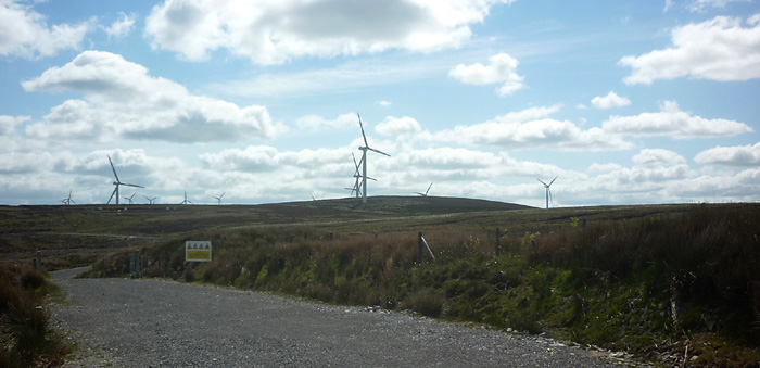
Picture: An uninspiring view to an uninspiring top.
Be thankful for the Wind Farm approach track.
by Harry Goodman
25 Jun 2015
As I was in the area on 8 June 2015 completing my revised Local 100 I decided to also visit Stranisk. Fore-armed is forewarned and in this regard I was fortunate to use (and would recommend) Sandman's starting point at the entrance to the Screggagh Windfarm Screga (H43879 56868) on the left (W) side of the B122 from Fivemiletown to Fintona. The good track led me up W, then S and then W again to Turbine 6 A (H42958 55967). Once past the turbine it was a short climb up the bank and out onto the broad heather covered swampy moorland to gain the unmarked high point of the hill. The walk up by the track was 2.5km. On my way back I decided to test the open ground and return directly from Turbine 6 across the moorland to Turbine 1, saving some 700 metres in distance over the trip up along the track.. Using this more direct approach up and back would therefore reduce the walk by some 1.5km. However be warned that the open ground is very rough and boggy, with patches of high heather. I would suggest, this is a walk where walkers will be glad to see and use a wind farm access track.. This is a low but very broad hill covered in high heather and bog so the track up makes for very easy progress. In all a walk of 5km up and back by the track or 3.5km if the more direct approach between Turbine 1 and 6 is taken. From the top there are expansive views to the high Sperrins, Slieve Beagh and Cuilcagh. Linkback: mountainviews.ie/summit/1128/comment/18161/
Read Less
Read More
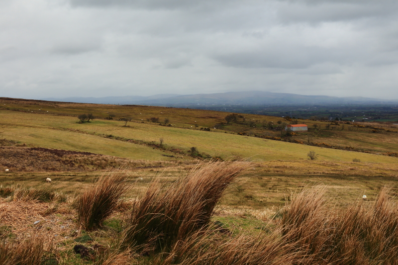
Picture: One the few views with no windmills!
A Forest Of Windmills
by Aidy
21 Apr 2016
My third and final small hill of the day, from my local 100, and the weather was getting progressively worse - not dramatic, stormy weather, which would have been preferable, just dull, grey skies and intermittent drizzle. Its hard to judge a hill under these conditions as nowhere will look at its best. To be honest, Stranisk probably needs all the help it can get, as it falls away gradually from the summit, with no spectacular views on ground far below. It is also completely dominated by windmills - I can't remember encountering so many on any other hill. It was almost a spectacle in itself. I used the resulting access road to get almost to the summit, and it led directly under the blades of several - always a slightly disconcerting experience I find, but on this occasion I was glad of the mild excitement it provided! Linkback: mountainviews.ie/summit/1128/comment/18502/
Read Less
Read More
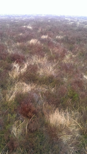
Picture: Summit Area
Windmills of your Mind
by sandman
22 Jun 2020
There are two windfarms situated in this area Lendrum Bridge and Screggagh the summit is situated in the latter adjacent to turbine 6 .Therefore the better parking option is at the entrance to Screggagh Screga (H43879 56868) where you can view the site map and walk on site roads to T6 and a short ascent will then bring you to the heather covered summit at B (H42845 55879). Linkback: mountainviews.ie/summit/1128/comment/15931/
Read Less
Read More
Windy top
by Fergalh
1 Mar 2014
Take the B122 south of Fintona drive up hill until you get to the entrance to Lendrum's bridge wind farm (Lendrum (H43762 54548)). The High point is on the wind farm.
Use of MountainViews is governed by conditions and a privacy policy.
Read general information about the site. Opinions in material here are not necessarily endorsed by MountainViews.
Hillwalking is a risk sport. Information in comments, walks, shared GPS tracks or about starting places may
not be accurate for example as regards safety or access permission. You are responsible for your safety and your permission to walk.
See the credits and list definitions.


 Our Facebook page.