Cookies.
This website uses cookies, which are small text files that the website puts on your device to facilitate operation. Cookies help us provide a better service to you. They are used to track general user traffic information and to help the website function properly.
Features
Nearby features appear when you click the map.
Declutter tracks on map.
Place Search
Video
X
Pub: by
Comeragh Mountains Area , Cen: Comeragh Central Subarea
Feature count in area: 24, all in Waterford, OSI/LPS Maps: 74, 75, 81, 82, EW-C, EW-K
Highest Place: Kilclooney Mountain 792m

Starting Places (25) in area Comeragh Mountains:
Aughatriscar Bridge, Carey's Castle, Carrickaruppora S, Carronadavderg Wood, Colligan Bridge, Colligan Source, Coumduala Lough Path, Croghaun Hill CP, Douglas River Wood, Dromona Wood, Guilcagh Wood, Kilclooney Wood CP, Laghtnafrankee Road, Lough Mohra Rath Beag Loop Walk, Mahon Falls CP, Maum Road, Moanyarha, Moanyarha Bog, Monarud, Mountain View, New Quay CP, Nire Valley CP, Old Bridge Clonmel, Old Slate Mine CP, River Ire R676 L96761

Summits & other features in area Comeragh Mountains:
Cen: Comeragh Central: Carrignagower 767m, Coumfea 741.9m, Coumfea North Top 728.3m, Coumfea West Top 711m, Croughaun Hill 391m, Curraghduff 750.1m, Kilclooney Mountain 792m, Knockaunapeebra 724.4m
Cen: Knockanaffrin: Knockanaffrin 755m, Knockanaffrin South Top 628m, Knocksheegowna 675.7m
E: Portlaw Hills: Donnell's Hill 242.8m, Tower Hill 238m
N: Laghtnafrankee: Kilmacomma Hill 211m, Laghtnafrankee 520m, Laghtnafrankee SW Top 425m, Long Hill 404m
S: Monavullagh Mountains: Bleantasour Mountain 402m, Coumaraglin Mountain 614.6m, Crohaun 484m, Milk Hill 451m, Seefin 725.6m
SW: Drum Hills: Carronadavderg 301m, Dromona Hill 156m

Note: this list of places may include island features such as summits, but not islands as such.
Rating graphic.
Coumfea West Top, 711m Mountain Srón Chom Fia A name in Irish,
Place Rating ..
(Ir. Srón Chom Fia [PND*], 'nose of the hollow of the deer'), Waterford County in Munster province, in Arderin Beg, Vandeleur-Lynam Lists, Coumfea West Top is the 106th highest place in Ireland.
Grid Reference S28112 09486, OS 1:50k mapsheet 75
Place visited by: 281 members, recently by: Tuigamala, kieran117, rhw, Carolyn105, Prem, Carolineswalsh, freelanb, NualaB, ToughSoles, benjimann9, Moirabourke, Ansarlodge, Beti13, Sarahjb, Mario77
I visited this place: NO (You need to be a logged-in member for this.)
Longitude: -7.589219, Latitude: 52.236879, Easting: 228112, Northing: 109486, Prominence: 16m,  Isolation: 1.4km
ITM: 628057 609539
Bedrock type: Green thick-bedded conglomerate, (Treanearla Formation)
Notes on name: Srón Chom Fhiaidh is the form given by Power. Other hills in the same townland (Lyre) are: Cnoc Bán, 'white hill', Cnoc a' Ghirrfhéidh, 'hill of the hare' and Cnoc a' Chrocaire, 'hill of the hangman' (PND).
  Short or GPS IDs, 6 char: CmfWst, 10 char: CmfWstTp

Linkback: https://mountainviews.ie/summit/102/
Gallery for Coumfea West Top (Srón Chom Fia) and surrounds
Summary for Coumfea West Top (Srón Chom Fia): Living on the edge
Summary created by jackill 2011-01-22 20:50:25
            MountainViews.ie picture about Coumfea West Top (<em>Srón Chom Fia</em>)
Picture: The Stilloge Loughs fom the summit
From the Nire Valley car park( Nire (S277 128)) , room for 20 cars but note this fills up fast on weekends, walk back down the road towards Ballymacarbery for about 500 meters. You'll come to a gate on your left with a muddy track leading down the slope towards the river.
Cross the river over a makeshift bridge and follow the rising track towards the mountains.
After passing a ruined farmhouse the track leads through a galvanised gate and out across the bog.
The track goes much further than shown on the map and although in places it is indistinct, you can follow it all the way to approximately A (S28313 11290) with little difficulty.
Pick your way past Lough Coumstillogemore and Lough Coumstillogebeg heading towards the very steep ascent to Coumfea West Top.
This looks quite tricky from below and certainly as you near the top there is a stretch of 20-30 meters of very exposed almost knife-edge to negotiate,in bad weather I would urge caution .
The summit is unmarked atop a peat hag.
Linkback: mountainviews.ie/summit/102/comment/4862/
Member Comments for Coumfea West Top (Srón Chom Fia)
Comment create / edit display placeholder

            MountainViews.ie picture about Coumfea West Top (<em>Srón Chom Fia</em>)
Picture: Lough Coumfea
jackill on Coumfea West Top
by jackill 28 Feb 2006
From the Nire Valley car park lace up the boots and walk back the road towards Ballymacarbery
for about 500 meters. You'll come to a gate on your left with a muddy track leading down the slope towards the river.
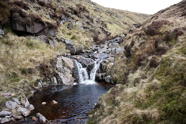
Cross the river over a makeshift bridge the farmer has constructed and follow the rising track towards the mountains.
After passing a ruined farmhouse the track leads through a galvanised gate and out across the bog.
The track actually goes much further than shown on the map and although in places it is indistinct, you can follow it all the way to A (S28313 11290) with little difficulty.
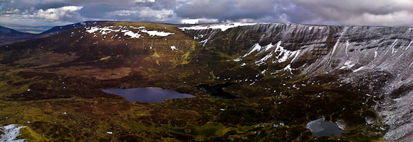
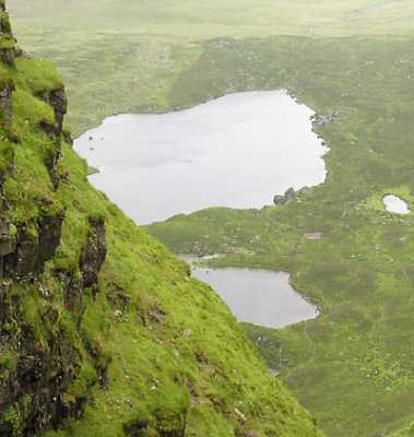
Take a few minutes rest among the scattered moraine boulders of the Coumalocha ,
also known as Lough Coumstillogemore and |Lough Coumstillogebeg on older maps, before tackling the very steep ascent to Coumfea West Top.
This looks quite tricky from below and certainly as you near the top there is a stretch of 20-30 meters of very exposed almost knife-edge to negotiate.
As you skirt the cliff edges views of the Galtys, the Knockmealdowns ,Slievenamon and the sea at Dungarvan open up around you.
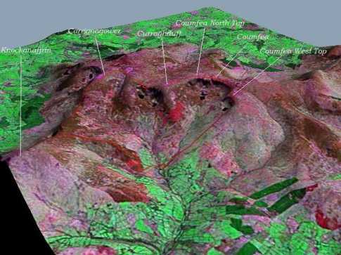
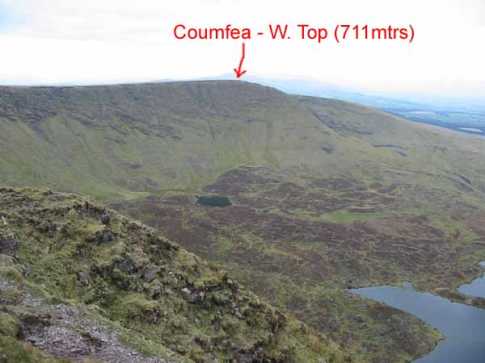
Puzzle for a while over where the summits of Coumfea and Coumfea North Top actually are (see if you can spot the meagre piles of stones).
Then head down the hillside to rejoin the track you walked in on and, after a welcome cuppa in the shelter on the scattered rocks at the track end,back to the car and home to a hot bath and a beer. 12.5 kms and 5 hours ambling.
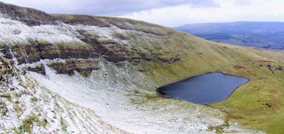
The photo is of Lough Coumfea from the steep side of Coumfea West Top Linkback: mountainviews.ie/summit/102/comment/2213/
Read Less
Read More

            MountainViews.ie picture about Coumfea West Top (<em>Srón Chom Fia</em>)
sinbadw on Coumfea West Top
by sinbadw 21 Oct 2004
This was the first hill we took in the circuit of the Nire Valley. We parked at the lay-by and walked down the road aways before turning left onto a track, over a bridge (of sorts) and thence over some stepping stones, followed by a sharp left to get out onto the mountain. You can see from the track that we then made our way pretty much straight on up to Coumfea West Top, skirting along the edge of the corrie to get some fantastic views of the lakes below. A small cairn maked the summit. The accompanying visualisation shows our path (roughly, forgive the section where we appear to walk on thin air, we were checking out the "sean bhean ag caitheabh tobac"). This was generated from Nasa SRTM data, a satelite image without colour correction and the gps log of our walk. Linkback: mountainviews.ie/summit/102/comment/1263/
Read Less
Read More

            MountainViews.ie picture about Coumfea West Top (<em>Srón Chom Fia</em>)
Picture: View of Coumfea W. Top from the East
john_desmond on Coumfea West Top
by john_desmond 18 Apr 2005
The summit of Coumfea West Top is the highest point of a spur that goes West from the Comeraghs. At 711 mtrs, it is debatable whether it is the required 15 mtrs higher than the nearest saddle to be listed on this site. The photo shows the summit from a viewing point to the East. As you can see, the spur is pretty flat. Leaving that aside, it still is a very nice area to walk on with some stunning views into the valley below. There is a very small stone cairn on the summit. I measured this at B (S2812 0948). Easiest access to this mountain is from the car park in the Nire Valley ( Nire (S277 128)) Linkback: mountainviews.ie/summit/102/comment/1655/
Read Less
Read More

            MountainViews.ie picture about Coumfea West Top (<em>Srón Chom Fia</em>)
Picture: Small lakes near Coumfea.
simon3 on Coumfea West Top
by simon3 11 Jul 2005
This top is called Coumfea in some accounts. It can be walked as part of a circuit of the Nire Valley or as I did in 2005 by coming north from Seefin. The summit is adorned with a very small pile of stones. As you walk from it towards Coumfea you circle round a huge, steep sided coum facing just east of north and over 1k wide. The views down from this includes a number of small lakes such as these two. Linkback: mountainviews.ie/summit/102/comment/1793/
Read Less
Read More

            MountainViews.ie picture about Coumfea West Top (<em>Srón Chom Fia</em>)
Picture: Glenastuckaun stream on the western slopes of Coumfea West Top
csd on Coumfea West Top
by csd 5 Apr 2010
I approached Coumfea West Top from the west, heading up Tooreen Mountain via Glenastuckaun stream after first climbing Milk Hill and Bleantasour. Parking in the woods at Tooreen East (see Milk Hill comment), these three summits can be done in four to five hours if you don't hang about. One of the pleasures of approaching from this side is Glenastuckaun Stream, which cleaves a deep channel through Foill Cam. Linkback: mountainviews.ie/summit/102/comment/4584/
Read Less
Read More
EDIT Point of Interest
text
Videos


Recent Contributions
x
Conditions and Info
Use of MountainViews is governed by conditions and a privacy policy.
Read general information about the site.
Opinions in material here are not necessarily endorsed by MountainViews.
Hillwalking is a risk sport. Information in comments, walks, shared GPS tracks or about starting places may not be accurate for example as regards safety or access permission. You are responsible for your safety and your permission to walk.
See the credits and list definitions.

OSi logo
OSNI/LPS logo
Open Street Map
(Various variations used.)
British summit data courtesy:
Database of British & Irish Hills