This website uses cookies, which are small text files that the website puts on your device to facilitate operation. Cookies help us provide a better service to you. They are used to track general user traffic information and to help the website function properly.
Challenge Walks. The Walkers Association used to maintain a calendar of Challenge Walks for Ireland. This has now been transferred to MountainViews.ie : visit the new location here. Also you might like to look at the newsletter's Challenge Walks Notes a generally monthly commentary on the Challenge Walk scene. MOUNTAIN MEITHEAL: Mountain Meitheal are keen to find more people to help. Future dates:
09.08.2015 16.08.2015 22.08.2015
06.09.2015 19.09.2015 26.09.2015 04.10.2015
17.10.2015 18.10.2015 01.11.2015 14.11.2015
We publicise Mountain Meitheal because they make practical repairs to some of the more popular areas we walk on, using a voluntary community based approach. (More information at their website.)
Picture of the month
The summit of High Spying How from Striding Edge in the Lake District (Eastern Fells). This is near Helvellyn. Photo by hivisibility. For Original Comment
Kinder Surprise
The Peak District is an upland area at the southern end of the Pennine chain of hills in the north of England. Its proximity to major industrial and population centres (such as Manchester and Sheffield) has made these moors and valleys very significant in the lives of a huge number of English people, and this indeed was Britain's first National Park as long ago as 1951. Its highest mountain, Kinder Scout, is a sprawlingly fascinating massif which was of huge importance in the history of free access to the hills in Britain. This month's highlighted track visits its scenic highlights and samples its vastness.
Note: As you may know, we recently started improving our shared track display. This is not finished by a long shot, however below shows how you can incorporate photos into a shared track.
Kinder Scout is the highest point in the Peak District National Park..
and also within the county of Derbyshire. It's gloriously English and eccentric, as if a folly were rendered in mountain form. It rears up steeply on all sides to 600m, then just seems to have been left totally unfinished as its climatic plateau sprawls over something like 10 square kilometres without ever getting higher than 636m. The plateau is a fissured brain of bog and grass and (especially) peat, the kind of place where taking a bearing and then successfully walking it are two very very different things. The edges of the plateau are fantastic though, studded as they are with all many of freakish outcrops of sculpted gritstone. There's nothing like it in Ireland, and not a lot like it in England either, if truth be told. Notwithstanding its geographical quirks, Kinder is possibly the most important hill in Britain when it comes to access, seeing as it is the scene of a famous mass trespass in 1932 that was instrumental in opening up the uplands of Northern England to the millions of folks living in reasonably close proximity to them.
Walking the plateau
I had walked over the plateau several times in my youth without ever visiting the highest point, but a glorious sunny day on a Derbyshire holiday was too good an opportunity to miss. If I couldn't locate the top in these conditions I would never manage it.
Crowden Brook
I started from the Barber Booth car park near Edale, and went up the course of Crowden Brook, a lovely moorland stream followed by an easy path that took a lot of pleasure in jumping from side to side of the water as height was gained. Once out on the plateau I headed west through the Woolpacks, a huge collection of huge gritstone boulders, before making for the isolated pinnacle of Pym Chair. This is roughly 500m SE of the highest point, and my research had suggested that the cairn adjacent to the summit would be visible from here. Of course it wasn't, so I decided upon a guaranteed outcome and banged a 10 digit grid reference for the top into the GPS. The WoolpacksFive minutes later I was standing over the tiny table of grass recently identified as the summit. The spectacular summit of Kinder Scout Objective achieved, it was time to reacquaint myself with some of Kinder's more obviously interesting corners. I dropped NE (well, dropped may be too strong a word) to the headwaters of the Kinder River, following it to Kinder Downfall. This is the source of the name of Kinder Scout, meaning as it does "Water that goes over the edge", for here the stream slips over a stepped 30m cliff (unless it is being blown back upwards by the wind funnelling up through the amphitheatre below, a frequent occurence). The walk alongside the embryonic river, along sandy beaches and through gritstone gateways is odd and enchanting...you'll never feel less like you are on a mountain top when you actually are anywhere. The surrounding plateau is very different from the one I remember 20+ years ago, the National Park having embarked on a very successful programme of soil erosion prevention and reseeding; the former oozy black desert is gradually being greened and softened. The Kinder RiverKinder Downfall: water blows back up.
Downfall
On arrival at the Downfall a while was spent on the usual struggle to find a viewpoint that can properly take in the hectic scene below you, before I walked on south along the edge on a good path, the lonely Mermaids Pool below on a shelf above the village of Hayfield. (Manchester is over in that direction too, but luckily you cannot see it too well from Kinder). I slanted up to the trig column on Kinder Low, perched on a large slopey gritstone boulder and only a couple of metres lower than the true summit (which is hilariously difficult to pick out even from this reasonably close viewpoint). The path continued south and down, past the huge roof of Edale Rocks on the right before a col at the medieval Edale Cross. A short rise led to an obvious path coming in from the left, which I took towards the valley. There was a steep and restored section called Jacob's Ladder (the whole walk since the Downfall has been on the Pennine Way) before a lane returned me to the start.
Whatever the length or terrain covered, please do submit suggestions for this "Featured Track" spot in future at admin -at- mountainviews.ie
NORTH: Another Donegal gem
Ganiamore Hill in Donegal NW is a mere 40 minute round-trip, but the views at the summit offer an enchanting tapestry of sea, land and sky, says Aidy.
Aidy on Gáinne Mór: Another Donegal Gem
Donegal seems to have an endless supply of these little hills around its northern peninsulas offering amazing views for very little effort, none more so than this. I went up on Sunday while out driving, just to get out of the house. I had little hope of climbing anything due to torrential rain and ferocious lightning. I am cautious about lightning after getting caught out on another hill on ver ... Click here
NORTH: Annalong day's journey into night...
thomas_g has visited the gorgeous Mountains of Mourne and come up with a variation on the eminently variable skyline of the Annalong Valley. On a good day this is very much one of Norn Iron's finest hillwalks, bringing you to the heart of the mountains visiting very dramatic scenery while (mostly) utilising clear paths. Anyone else choosing this itinerary can carry out their own modifications: Donard can be omitted by staying on the Brandy Pad, as can the out-and-back Chimney Rock Mountain, while adding Binnian to the start is well worth the extra effort.
thomas_g on Tour of the Annalong Valley
This is a variation on a walk in the book 'Best walks in Ireland'. There is plenty of parking by the gates at th| walk, Len: 20.1km, Climb: 1293m, Area: Rocky Mountain, Mourne Mountains (Irela Click here
NORTH: Iconic tower tops the summit
Scrabo Hill is just a few minutes walk from a car park, or offers a 3.7km walk exploring the sandstone quarries, that rock being used to build the iconic tower that marks its high point, reports kernowclimber.
kernowclimber on Scrabo Hill: Towering views over north Down and beyond
Scrabo Hill, an AONB, rises dramatically above the town of Newtownards and the surrounding plain. The view from the hill is exceptional, extending across Strangford Lough to the Mourne Mountains, the Isle of Man and the Scottish coast. It has been a place of human habitation from the Mesolithic through the Bronze and Iron Ages; the density and number of hut circles and the remains of an extensive ... Click here
WEST: As isolated as you can get
Member wicklore explores the remote Tawnyanruddia in the Nephin Beg range, and relishes the sense of wilderness and isolation as far from civilisation as you can get in Ireland.
wicklore on Tawnyanruddia: Take your time to enjoy
5 years ago this August I climbed Tawnyanruddia on my way to Slieve Carr. I had camped the night before in a dilapidated tin hut on the Bangor trail below at F 90646 11359 where the Bangor trail contours around the hill. I wrote about that singular experience back then as part of a summit comment for Slieve Carr. It was a hugely enjoyable and challenging way to experience this area of near wildern ... Click here
WEST: Midge country…
Bencorrbeg in the Twelve Bens is a very fine rocky summit, but is a favourite spot of Ireland’s midge population, reports peter1.
peter1 on Bencorrbeg: Working hard for your lunch...
Climbed this with two friends on a very calm, humid and midge infested Wednesday in July. The midges even followed us to the summit! We continued on in cloud and rain to Binn an tSaighdiura and Bencollaghduff to descend to the car at the farm in Gleninagh (A). An excellent and tough day out. Click here
Featured summit comment Worthy Arderin Beg This Short Summary is by Onzy
Droppa is a satisfyingly shaped peak well situated in the circuit of hills surrounding the Glantrasna valley, and overlooking Glanrastel to the south.
It will most usually be reached from Cummeenbaun. From Glanrastel, parking at V80498 57651 A, over Cummeenbaun to the summit, and from Glantrasna, parking at V82637 59648 B, up the ridge to Cummeenbaun and onto Droppa itself.
It can be combined in a number of longer routes, particularly the circuit of Glentrasna, parking at either V82637 59648 B or V80519 60522 C allows access to a round taking in Knockreagh, Coomnadiha, Caha (not MV-listed), Droppa and Cummenbaun. In either case an amount of road-walking will be necessary.
SOUTH: Kill Hill Vol. 1
This month conormcbandon continues his quest to render the lowly hills of the Irish Midlands about as challenging as the Darién Gap on the Pan-American Highway. Having been thwarted in his attempts on Kill Hill via the access roads to the embryonic wind farm on its slopes, he turned his attention to a western approach using farm roads, forestry and a quarry. That seemed to work out quite well, so logically strife had to be sought by a recce of potential accesses from the north...this seems to have involved cattle whose maleness couldn't be accurately ascertained until he was a bit too close for comfort. All good fun, and as this obviously isn't a full day on the hill summiteers should be aware of the numerous other similar objectives around the M8.
conormcbandon on Kill Hill and it's wind turbines
I attempted an approach from the east using the wind farms roads but seeing the numerous no access signs and a camera I | walk, Len: 4.7km, Climb: 0m, Area: Kill Hill, South Midlands (Ireland) Kill H Click here
SOUTH: Hair-raising ascent in rough conditions.
Cnoc na Peiste is a tough ascent at the best of times, but in rain and mist and with slippery moss underfoot, it can be quite a treacherous climb, recounts Aidy.
Aidy on Cnoc na Péiste: Difficult In The Conditions
Approached from the Big Gun on an Eastern Reeks traverse. Weather was terrible for this section with rain and low cloud. We dropped below the ridge on the south side, crossing difficult terrain, scrambling over large, slippery rocks in poor visibility. The ascent back up to the summit was steep, and a bit hair raising in the conditions. Hands were required as rocks were treacherous, and moss g ... Click here
SOUTH: Measure for measure...
jackill has taken his Trimble thing to the isolated Slievenamon massif in the south, and having followed the traditional route to the parent summit has then spent a few hours measuring the various adjacent tops to the north. These included the already-recognised Knocknahunna but also the newly-sprouting NW and NE tops of Slievenamon itself. The route doesn't conveniently link to anything else, and a look at the map suggests that it might be made slightly shorter using a start from the north (see comments under Knocknahunna for details).
jackill on A circuit of the Slievenamon Tops
| walk, Len: 11.9km, Climb: 674m, Area: Slievenamon, South Midlands (Ireland) Slievenamon, Slievenamon North-West Top, Knockahunna, Slievenamon North-East Top Click here
SOUTH: There and back (and there and back) again...
Meanwhile, down in the south-west Onzy has been examining some of the new tops on the ground with a deeply contorted course over Sugarloaf Mountain and Nareera, a lot of hither and thither being necessatated by the benches of rock so typical of this area of Ireland. Refinement of the submitted route rather than its extension would seem to be the only possible variation as these tops lie a fair way from anything other than much less significant summits, although an early start should mean enough daylight is spare to attempt something else in the vicinity...there are a lot of summits lining up along the peninsula.
Onzy on Cahas: West of Glengarriff
Route taking in the 3 Sugarloaf Mountain tops and the 3 Nareera tops. Parking is at V849 511, at the bottom of a mountai| walk, Len: 11.2km, Climb: 862m, Area: Nareera, Caha Mountains (Ireland) Naree Click here
EAST:Two "new" summits in Kilkenny
Slievenamon’s smaller brothers, the NE top and NW Top, fall into the new Arderin Beg category, and are explored by jackill.
group on Slievenamon North-East Top: A great view of south Kilkenny
mountain is on a substantial track so you can't really go wrong, just follow it uphill with the forestry on your right.
At the top of this track is a concrete building with bits of decaying aerial near it. Go past this uphill to the north on a gradual slope to the summit area of Slievenamon. Head downhill north on steep ground before a gradual rise to the summit of Slievenamon North-West Top whic ... Click here
EAST: Heathery Wicklow hump.
One of the new Arderin Beg listings, Croaghanmoira North Top is a typical Wicklow top, but an easy hike up a track, and has great views, says wicklore.
wicklore on Croaghanmoira North Top: Heathery Wicklow hump
Croaghanmoira North Top is an easy summit to reach as it is close to the road which runs south from Glenmalure, and has a good track most of the way up. It will most likely be combined with Croaghanmoira for a compact walk, or extended along the Fananierin ridge (A spur running north from Croaghanmoira North Top) to take in Fananierin also. There is parking for a few cars at a Coillte forestry en ... Click here
EAST: Table Manners
Following the madfrankie-shaped cat that was released among the Arderin pigeons with the introduction of the Beags recently, exploration of all the 'new' tops continues apace with many members looking at familiar areas with new eyes. As a result Wicklow is taking even more of a hammering than usual, as its general high altitude and lumpiness very much lends itself to the whole ">=500m with 15m separation" thing. mcrtchly and kernowclimber have visited the north side of the Glen of Imaal with a route that leads up through the forest to Lobawn while taking in a new summit on both the ascent and the descent. This walk could be extended further around the head of the Glen to the south-east, and even as far as Lugnaquilla for the properly determined.
mcrtchly on A visit to two new MV summits in the eastern Glen of Imaal
| walk, Len: 11.7km, Climb: 465m, Area: Table Mountain West Top, Dublin/Wicklow (Ireland) Table Mountain West Top, Lobawn, Sugarloaf Click here
MIDLANDS: A woodland stroll with the kids.
Hewson Hill is a heavily forested rise in Laois, which takes just over an hour to bag, even with the kids in tow, reports member arrow.
{{item=}mtn_ct18191}}
MIDLANDS: For the devil of it.
Devilsbit Mountain in the eastern Shannon area is a plateau-like hill that offers fine views and the option of a quick stroll to the top or a longer loop walk, says sandman.
sandman on Devilsbit Mountain: The Devils Loop.
Depending on the off road ability of your vehicle you can park without obstructing anyone at S0581075238 which will give you the option of a quick up and down to the trig or a pleasant Loop Walk visiting Little Rock with its cross and statue. If you decide on the loop which i did in an anti-clockwise direction access is via the gate into the forest , go left and left again which will take you to L ... Click here
Sorry if we didn't mention what you posted .. there's a list of all contributors for the month later.
MOTLEY GATHERING
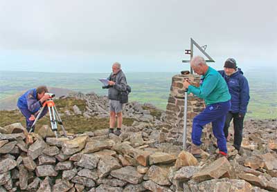
Visit of hill surveyors from Britain - meetings, field trips and a MountainViews BBQ
On 4th- 6th Sept, 2015, we are going to welcome a British group DoBIH (the Database of British and Irish Hills) to discuss and participate in a spot of hill-surveying. Hill lists are an important part of what MountainViews does and measurement is a small but important part of lists. It's good to discuss what we are doing with others doing the same thing therefore.
Surveying on the summit of Yr Eifl in Wales at our previous meet up. Behind is the misty coast of the Irish Sea beyond which Wicklow can sometimes be seen. Although small, the black and yellow Trimble unit with our own John Fitzgerald (right) can just be seen taking measurements on top of the trig pillar. It turned out to have very similar accuracy to the Leica gear used by DoBIH.
The programme will be based in Wicklow and will include
Fri 4th Sept, 16:00ish, meeting at Knockree Hostel to discuss matters of mutual interest.
Sat 5th Sept, 10:00, joint surveying - may include Lugnaquillia
Sat 5th Sept, 19:00, BBQ
Sun, 6th Sept, 10:00, more surveying
General welcome
If you're a member of MV and want to come along and have a look you are most welcome, indeed if you offer to lend a hand carrying gear up the hills you are likely to be taken up on the offer. The surveying programme will be coordinated from MV's end by John Fitzgerald (jackill).
Members (+1) whether involved with surveying or not are most welcome to come to the BBQ (assuming that we have capacity - please check). Meet our guests and other members of MV. Get in touch at admin@mountainviews.ie for a fuller programme, directions etc.
You can see a report about our previous meeting in the September 2013 version of our newsletter at mountainviews.ie/newsletters/month/2013-09/ where amongst other things there is a an explanation of why MV and others ever got involved with hill surveying.
You can find out about the "DoBIH" (Database of British and Irish Hills - www.hills-database.co.uk/. We have had reciprocal arrangements for sharing data with this group for some time and in early Sept 2013 we met up with them to compare methods
Share your ideas on track improvement on Errigal
simon3 on Share your ideas on erosion on Errigal
From Mountaineering Ireland.
Note: You can send emails to the person conducting the survey (or phone him) as outlined, up util the 8th Aug 2015.
Why should you do this?
"Repair" done by county councils (for example near Slieve League) has often been of extremely low quality, frequently ruining any of the special qualities of the place it was supposed to have fixed. Don't let repair go to the l ... Click here
Ridge north of Aghla Beg (Derryveaghs). Useful bit of geology.
mcrtchly on Aghla Beg ridge
In response to a query from jsramsey1491 about the prominent ridge north from Aghla Beg, although this appears to be a glacial deposit it is in fact bedrock (quartzite) according to the Geological Survey. Its curious form was probably the result of being eroded on the east and west sides by two separate glaciers as they flowed northwards from the corries of the Aghla mountains.
There are oth ... Click here
Want to choose the summit comments for next month
Our regular commentator on summit comments is going to be away so for next month would you like to review the summit comments (and photos, short summaries) for the Sept newsletter? Let us know as admin -at- mountainviews.ie
Re Dingle access issue change recommended for getting to places like Beenbo or Annascaul from the "Ballyduff Graveyard"
Last month we told you that we had made changes regarding access advice to Beenbo/ Slivenagower/ Slievenalecka. These followed officially (MI) suggested changes to advice access. Following this I received an email from one of our members who said he had met the relevant landowner just this spring and had been given permission to walk directly up from Ballyduff Graveyard via the south spur of Beenbo. He suggested that asking politely could often get you where you want to go - something we have always supported on MV
This is quite an illustration of aspects of the access issue in Ireland. Apparently the landowner will allow access in practice if asked nicely but doesn't want it in a book. What he would say about a user suggested route on a website such as MV we don't know - though of course it is much easier to change a website than a book.
MV is sticking with the official advice, but it would appear that the official advice can be supplemented with some relevant experience.
MV Strategy
Just a reminder about this item which was covered more fully in previous months and thanks for those that contacted us about it.
The Committee’s Draft Strategy for MV is now available here. We invite input from all members of the Community as to how this should be further shaped. Any comments, criticisms, corrections, etc., are welcome on OnzyMV@gmail.com
CHALLENGE
A place for those interested in Challenge Walks
We heard that the Joyce Country Challenge ran into bad weather. Note: we will have a proper report explaining what actually happened next month.
There's another walk not so far away on the 8th Aug, the Marathon Walk Western Way. (Details in our calendar)
Then there's the three day FEI SHEEHY CHALLENGE (Galty, Comeraghs and Knockmealdowns) over the 21st-23rd Aug.
Mourne 7X7s Photo: Peter Walker
Mourne Seven Sevens
The first day of August fortuitously brought both weather conditions somewhat improved from the ghastly dank cold that had beset most of July, and the annual Mourne Seven Sevens challenge. This is a hugely popular event taking in the seven highest summits of the mighty Mournes, and this year saw almost 300 people congregate in a Newcastle car park before sallying forth for fun and frolic and an indecent amount of ascent and descent. MV's track reviewer and videographer had gone a fair few years since last he attempted this sort of thing, and interested parties who can bear the tension can check out his uploaded track to find out just how his performance compared with the first Irish man to climb Everest...as if there were any doubt about it.
In relation to said Everest Summiteer (Dawson Stelfox) and in the possibly unlikely event he actually reads this newsletter can I say as editor that we welcome his venturing onto a challenge in the Mournes and hope he will try some more in the calendar or perhaps the engrossing activity of Irish summiteering.
So be sure to checkout a Challenge Walk near you . . . .
-- Simon Stewart and Peter Walker in the absence of Jim "Jumping" Holmes who is on holiday.
Summit change proposals
As many will know we introduced a system to allow users to propose changes to MV's database for summits. ("Propose Place Database Change") earlier this year and so far we have had over 130 proposals, most of which have been accepted.
The following is from member jackill who manages the change proposals for MV:
Dear Members,
Thank you all for the many change proposals we have received since the this feature was introduced, indeed we look forward to many more.
A few observations of some common issues we could use your help with when proposing changes.
Please always fill out the "Change Reason" field, it may not always be obvious to us what the point you are making is. Please fill out as many of the data field as you can.
When proposing a hill be added to the local/historic/cultural list note the following, for inclusion a summit will need to fulfil at least one of these and we expect the proposer to include this information for consideration at the time of the proposal.
Is the proposed summit significant locally? Does it ,for example, dominate the landscape?, is there a natural feature worthy of mention?
Is there historic significance? For example was it the setting for a battle? is there a fortification or ruin on the hill? Is there cultural significance? For example has it significance in the arts or traditions of an area?
New banner
We have changed the banner we have for the website, using one supplied by member Aidy. Now, the question is, what are the hills in the banner and/or where was the pic taken from? answers to admin -at- mountainviews.ie. Answer correctly and you will be celebrated in song, in the next newsletter, with a case of champagne, with a visit to the place. Some of the foregoing could even happen. Hint: it is in the island of Ireland.
Upload to a Garmin GPS unit
Since we introduced the track sharing system there has been a method for exporting shared tracks. This takes two forms: "Download a GPX file" and "Upload to a Garmin GPS unit". For Garmin users (the vast majority of people using standalone GPS units according to my experience) this is really handy. You can go directly from the website to the device using a supplied cable. Seriously neat. Used by many many other websites as well as MV.
Bad news I am afraid. This feature relied on a tool provided by Garmin ("Garmin Communicator") which relied on a method supported by browsers such as Google Chrome, Firefox and MSIE. The browser manufacturers have deemed the method insecure and are phasing it out. Garmin has apparently not decided to replace their tool with something similar. So you are likely to find that following a browser update the "Upload to a Garmin GPS unit" feature will die - usually saying that Garmin Communicator plugin is not available or some such. If a replacement becomes available, we will see what we can do.
Meanwhile you can still export data to a GPX file and use other software to get it onto your device.
Improvements to GPS tracks - photos and formatting
We are enhancing the GPS track sharing as discussed in the last two month's newsletter and the first phase is now out in a proving mode. Take a look at the sample at
Note: when including photos in shared tracks, in general it is best to reduce their size which can be done using the editing tool. This is because otherwise users are forced to scroll too much. Ah, I can hear you say. But what about people seeing the detail in my magnificent pictures? Hrmph!
The way we have dealt with this for the mountain summits in the website is to use the Gallery feature. If you click on a summit or on the “Gallery” button in a mountain page then the pictures are shown large size.
We are now implementing this for tracks also. The gallery view shows pictures at their maximum stored working size of 800px width, which is much better than the 545px available in the track description.
This month look out for some new enhancements, including: formatted editing (with photos) of summits at first entry (ie. just after Uploading a Track) and the extension of the Gallery system as described.
Let us know at admin@mountainviews.ie of any teething troubles or lack of clarity in how to do things.
Do you have ideas as to what you would like to see regarding our track sharing? Please do contact us at at admin@mountainviews.ie We will do a series of enhancements, however may not return to this area for some time, so now is your chance to propose changes.
BOOK REVIEWS
Book review: KILLARNEY TO VALENTIA ISLAND - THE IVERAGH PENINSULAby Adrian Hendroff.
Publisher: The Collins Press
Adrian Hendroff has just written my favourite walking guide! I loved this book. I read it and I re-read it. I anticipate that within a short period it will become the most worn book in my possession.
Admittedly, I am not unbiased. I live in south Kerry. I have walked each of the 29 routes contained in this guide, some of them on numerous occasions. However, I actually opened it with a certain trepidation, a “what can he tell me that I don’t know already”. Well as it turned out, lots. The book is crammed with interesting references to the social and cultural history, this is a writer who has evidently done his homework. He shows an affection for his task beyond the mere recording of distance, ascent, duration etc.
However, this should not deter the newcomer to south Kerry. It is extremely user friendly, and should appeal to everyone. The writer clearly knows what is expected in such guides and helpfully provides the fundamentals along with maps and his own grading system (which, although subjective, should be extremely useful, and I certainly could not fault it). He describes how to get to the start points and where to park - such a simple matter but again extremely valuable in a peninsula that is not known for wide roads, good signage and – apart from Killarney and the Reeks - carparks. He then provides 3 or 4 pages of detail on each walk with numerous grid references but also sufficient information to keep the amateur walker on track. He always has an eye on the interesting, whether it be social or cultural, places to take in the best views, or even the quirky...I thought I was the only person who had looked at the boulder between Bascadh and Knocknacappul and thought it resembled a sofa!
In an area where the Reeks are the obvious attraction, I love the fact that the writer has opened up the lesser known routes in the Dunkerrons, the Mangertons and the mountains behind Glenbeigh. I think this is a book that will be enjoyed by everyone from those living in the shadow of these summits like myself to the person landing in for the weekend or a week. I have found so many other walking guides to be too narrow and centred on Killarney, or too broad – this is ideal for someone visiting for a few days, with a car and with an eye on tackling some of Ireland’s most stunning but least known walks.
If I have one criticism, and I suspect it is one that the writer of “From High Places” would accept, it’s that the format of the book does not do justice to all of his photographs. This is a small guide, and of necessity photos are somewhat cramped with detail. But of course there is there is a very easy way to overcome this issue; buy this book, come to the Iveragh peninsula, and capture the breadth and depth of the scenery for yourself!
-- Conor Murphy
SUMMITEERS CORNER
A place for those interested in Summiteering, Bagging or Highpointing.
A Guide to Ireland's Mountain Summits - The Vandeleur-Lynams & The Arderins
MountainViews first book available online and in many bookshops. The first reprint with numerous minor amendments is available.
simon3 on A Guide to Irelands Mountain Summits
MountainViews first book available online and in many bookshops.
As members will know, for over a decade, Mountainviews.ie has been providing unique information to hillwalkers on all aspects of exploring and enjoying Ireland's upland areas. It's been a collaborative effort by over 1000 of you, and currently contains over 6000 comments on 1057 mountains and hills on the island of Ireland ... Click here
Bulk sales to groups such as Scouts/ Guides: contact admin@mountainviews.ie for a discounted price.
Summary.
MountainViews now has 7617 comments about 1387 different hills & mountains out of the total in our current full list (1492). We want to get a good gps track showing each of the major ways up every summit in Ireland. If you see an option to add a "Short Summary" then do please consider creating one since another objective is to have a short summary for every summit in Ireland. There's a few (105) opportunities for you to be the first to comment on a summit.
NOTICES
Notices
If you are contributing, please be careful to respect the interests of landowners.
Suggest access routes well away from houses, gardens or that could conceivably impact farming activities. When walking, keep away from gardens or farm buildings. Use stiles or gates wherever possible. Never do anything that could allow animals to roam where the farmer did not intend. Ask permission where appropriate.
Report suspicious activity to the police forces, as below.
If your car is broken into in an upland area report it to the PSNI or Gardai as this will help them be aware of the issue and tackle it in future. Store the numbers. In Northern Ireland use the PSNI non-emergency number 0845 600 8000. In the Republic you can find the local Garda District HQs phone numbers at www.garda.ie/Stations/Default.aspx. Specifically for the hotspot of Wicklow: the Garda Divisional Headquarters in Bray is 01 6665300.
If you hear of a problem area or route, write it up in MountainViews
which does everyone a service.
Report rubbish tipping in the Republic - ring EPA hotline 1850 365 121
Report quads in national park area (in which they are banned). For Wicklow please phone the Duty Ranger: 087-9803899 or the office during office hours Telephone: +353-404-45800. Put these numbers in your phone, take regs etc. Let MV know of contact numbers for other areas.
If you have climbed some of the less well known places, we would appreciate a summit rating and also GPS readings for summits.
If we can, let's make MV have more than one route up a summit so as to reduce the tendency for paths to appear. Your grid refs in comments for different starting points show up on MountainViews maps as well as GPS tracks.
MountainViews are on Twitter as MountainViewsIE. Follow us and we will follow you back. Any queries to secretary@mountainviews.ie
Visit the MountainViews Facebook page.
This newsletter
This newsletter
Editor: Simon Stewart, Homepage:
www.simonstewart.ie
Assistant editors: Colin Murphy, David Owens
Track reviews: Peter Walker, Tom Condon
Book reviews: Conor Murphy, Aidan Dillon, Peter Walker, Michael Kinahan
Videography: Peter Walker, Video Reviews: Paul Moore
Graphics design advice: madfrankie
Facebook assistant editor: Simon Byrne
Click on (If you have cookies on in your browser then you will be prompted as to username/ password. If you forget the password, the login page can email you a replacement.)
UNSUBSCRIBING
If you don't want to receive any further monthly newsletters from Mountain Views click on
Settings. Then change the option beside "Include on occasional mailing list" to "Do not include". Then click the "Save" button.
Alternatively let us know by email at admin -at- mountainviews.ie Include the email address you got this at or your screen-name guestuser.
 Quarterly May 2024

 Kinder Scout is the highest point in the Peak District National Park..


 Worthy Arderin Beg


 Adrian Hendroff has just written my favourite walking guide! I loved this book. I read it and I re-read it. I anticipate that within a short period it will become the most worn book in my possession.
