This website uses cookies, which are small text files that the website puts on your device to facilitate operation. Cookies help us provide a better service to you. They are used to track general user traffic information and to help the website function properly.
Feature count in area: 58, all in Down,
OSI/LPS Maps: 20, 29, EW-CLY
Highest Place: Slieve Donard 849m
Starting Places (33) in area Mourne Mountains: Alex Steddom Tree, Aughrim Airstrip, Ben Crom Dam, Bloody Bridge Car Park, Carlingford Greenway, Carrick Little, Crocknafeola Wood, Crotlieve Mountain, Donard Car Park Newcastle, Drummanmore Picnic, Fofanny Reservoir, Forest Office CP, Gamekeepers Lodge CP, Happy Valley Trassey Rd, Hen Mountain CP, Leitrim Lodge CP, Mayo Road Corner, Meelmore Lodge, Newcastle Harbour, Ott CP, Red Bog Road, Rourkes Park, Sandy Brae, Silent Valley Reservoir Head Rd, Slieve Donard Trail Head, Slieve Foye Viewing Point, Slievefoy Forest CP, Spelga Dam E, Spelga Dam N, Spelga Dam S, Trassey Car Park, Two Mile River CP, Yellow Water Park
Summits & other features in area Mourne Mountains: Cen: Loughshannagh: Ben Crom 526m, Carn Mountain 585.2m, Carn Mountain North Top 553.7m, Doan 592.6m, Ott Mountain 526.8m, Slieve Loughshannagh 617m, Slieve Muck 670.4m, Slievenaglogh 445m E: Binnian: Slieve Binnian 745.9m, Slieve Binnian East Top 639m, Slieve Binnian North Top 678m, Slieve Binnian North Tor 682.5m, Wee Binnian 460m E: Donard: Chimney Rock Mountain 656m, Crossone 540m, Millstone Mountain 460m, Rocky Mountain 524m, Slieve Donard 849m E: Lamagan: Cove Mountain 654.8m, Slieve Beg 595.9m, Slievelamagan 702.2m N: Bearnagh: Slieve Bearnagh 739m, Slieve Bearnagh North Tor 680m, Slieve Meelbeg 701.9m, Slieve Meelmore 687m N: Castlewellan: Slievenalargy 280m, Slievenaslat 272m N: Commedagh: Slieve Commedagh 767m, Slieve Corragh 641.9m, Slievenaglogh 584.4m, Slievenaglogh East Top 571m N: Croob: Cratlieve 429m, Slieve Croob 534m, Slievegarran 391m, Slievenisky 446m N: Rathfriland: Knockiveagh 235m S: Kilkeel: Knockchree 306m S: Rostrevor: Crenville 460m, Finlieve 578m, Slievemartin 485m, Slievemeel 420m, Slievemeen 472m W: Hilltown: Gruggandoo 382m, Slieveacarnane 296m W: Slievemoughanmore: Crotlieve Mountain 347m, Eagle Mountain 638m, Rocky Mountain 404m, Shanlieve 626m, Slievemoughanmore 560m, Tievedockaragh 473m, Wee Slievemoughan 428m W: Spelga: Butter Mountain 500m, Cock Mountain 504m, Cock Mountain South-West Top 505m, Hen Mountain 354m, Pigeon Rock Mountain 534m, Pigeon Rock Mountain South Top 530m, Slievenamiskan 444m
Note: this list of places may include island features such as summits, but not
islands as such.
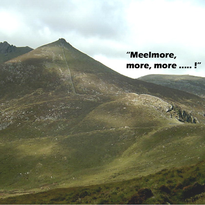
Slieve Meelmore, 687mMountain Sliabh Míol Mór A name in Irish,
Place Rating ..
(Ir. Sliabh Míol Mór [PNNI], 'big mountain of the ants'), Down County in Ulster province, in Arderin, Vandeleur-Lynam, Irish Highest Hundred Lists, Slieve Meelmore is the 133rd highest place in Ireland.
Grid Reference J30594 28702,
OS 1:50k mapsheet 29 Place visited by: 691members, recently by: Muscles1960, eimirmaguire, Henning86, rhw, Nailer1967, knightsonhikes, Courin, MeabhTiernan, Deirdreb, orlaithfitz, davidrenshaw, Magic, Prem, Carolineswalsh, ronanmckee
I visited this place: NO (You need to be a logged-in member for this.)
Longitude: -6.000668, Latitude: 54.189586, Easting: 330594, Northing: 328702,
Prominence: 109m, Isolation: 0.8km ITM: 730479 828585 Bedrock type: Granite granophyre, (Mourne Mountains granite) Notes on name: A substantial tower has been built on the summit. The spot height is given as 704m on the 1:25,000 map, but this does not square with the contours, which only go up to 680m. Spellack (speilic, 'a splintery rock', probably ultimately derived from Latin spelunca, ‘cave, den’) is a spur on Slieve Meelmore.
Short or GPS IDs, 6 char: SlvMlm, 10 char: SlvMlmr Linkback: https://mountainviews.ie/summit/138/
Gallery for Slieve Meelmore (Sliabh Míol Mór) and surrounds
Summary
for Slieve Meelmore (Sliabh Míol Mór):
Steep-sided, easy-access peak in the Northern Mournes
Summary created by markmjcampion, Peter Walker
2021-03-29 12:44:42
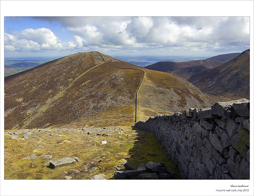
Picture: Meelmore from Meelbeg
Near Newcastle, Slieve Meelmore is a steep-sided whaleback crossed by the Mourne Wall with some substantial crags overlooking the hollow of Pollaphuca on its E flank. It's a great perch from which to drool over the nearby peaks and crags of adjacent Bernagh as well as Donard, Binnion and the rolling hills of mid County Down.
N. Start from the road near the substantial car park at TrsyCP (J31128 31420), following the Trassey track as far as the right turn at A (J31854 29187). Head for Pollaphuca and the dramatic col between Slieve Bearnagh and Slieve Meelmore. From here the summit is gained by a straightforward and steep ascent alongside the Mourne Wall. 1.5 – 2 hrs
Alternatively, head up to Hare's Gap and tackle S. Bernagh before coming to the col mentioned above. Be warned though of the very steep descent from Bernagh.
NW. One can also start from the picnic site further up the road HpVlTr (J29280 29707). From here a path can be followed up the stream valley falling from the Meelmore/Meelbeg col. The stream guides the way once the path fades although the ground is rough and boggy, and the summit is easily gained following the wall from the col. 1.5 hrs
SW. Meelmore is at the end of a fine SW-NW ridge starting at Slieve Muck. Join the ridge wherever takes your fancy and follow the Mourne Wall as it snakes steeply over Slieve Meelbeg before arriving at the aforementioned col.
Notable tracks include track/2021 and track/3936 and if you can do a car split track/2335.
Meelmore is an odd critter. To all intents and purposes, she is fairly dull, although she can surprise you with postcard views along the ridge to Donard and in the winter, her Eastern flank is a glistening must. She is a big hill and so, inspired, the cartographer entitled her, “Meelmore”. She is neighbour to the more ostentatious Bearnagh and sibling of her smaller sister - yup you got it: “Meelbeg”.
Shall I relate a tale of explicitness from the outset? Of course I shall. Some balmy summers ago, I and the bumblebees were exploring this big warm earth mother. Atop Meelmore, there is (as on Donard) a somethingorother at the elbow of the wall, a stone structure with a roof and the smell of a bad pub. I was skirting this folly, enroute to Spellack, when I noticed that she, naked as God made her (and he certainly did) had him (pale, thin and nervous), pinned to said edifIce. As her, he was birthday bare other than his ankles, whose modesty was covered by his kecks. When he saw me, he drew said kecks up so hard they nearly came off over his head and then stood catatonic, with them up to his armpits, which as we all know only makes matters worse. She, was doing a kind of female Lee Evans: right no left no right no …. and so she stopped, like a child sprayed with freezing water: arms out and fingers flapping like skylark wings. Dull old Meelmore ……. and she addressed me through a meteor shower of giggles, squeals and snorts, “you should have bells on your feet”. Clucked I in true Ulster disapproval “and you girl, should have bells on your toes.” And so the shaky beginnings of the Meelmore High Club. Linkback: mountainviews.ie/summit/138/comment/1327/
Read Less
Read More
short hike but amazing
by fatredline
7 Jul 2014
Bypassed Newcastle for this one headed toward tullymore forest park then the mourne high scenic route which is on the left further on up the road there's a car park near fofanny dam its on the mourne activity map my new found bible I think the route goes through some private land but its easily enough navigated just walk your way up to the mourne wall you can see it from the car park near enough and follow left once u get near the top there's some great views of Ben Crom reservoir there is also some tough gradients to the summit very rocky but totally worth the view into the mournes from the east got caught out in a hail and thunder on the way down was my first experience of a mountain storm. Linkback: mountainviews.ie/summit/138/comment/17541/
Read Less
Read More
Picture: Meelmore from Meelbeg
A strange beast
by paulocon
14 May 2010
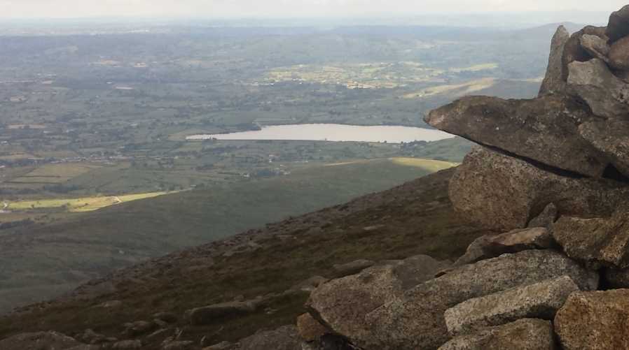
From some angles, it really is a strange beast.. kind of like a beached whale or the back of an elephant. Whatever it is, it had loads of people scurrying up, down and around it! For summit baggers, there are huge gains to be made with Carn, Loughshannagh, Meelbeg, Meelmore and Bearnagh so close to each other and the walking (with the exception of that climb up Bearnagh) pretty easy going.
As for that climb up Bearnagh! From Meelmore it looks impossibly steep, ridiculous even! Even glancing across at it was causing my legs to cramp so I decided to cross the wall and take a dander up to the summit proper of Meelmore to take my mind off the task ahead. That summit lies a hundred metres or so away from the watch-tower (what exactly was 'watched' from these towers?) and is marked with a cairn. My 'quiet time' at the top was interrupted by that rarest of creatures, a fell runner, and before I had time to raise my hand to salute him, he was off round the corner and was descending towards Bearnagh in what I can only describe as an uncontrolled and impossibly fast stumble.
I decided to stick to what I know best and slowly picked my way down across the rocks to the gap between Meelmore and Bearnagh before heading off up the ridiculous gradient.. Linkback: mountainviews.ie/summit/138/comment/4731/
Read Less
Read More
Happy Valley Hike
by hbowman
22 Aug 2010
I climbed this mountain today for the 4th time, but decided to approach it from different angle. Started off from the Happy Valley car park (B (J293 296)) and followed the path, beside a lovely stream up to the Mourne wall at the saddle between Slieve Meelmore and Meelbeg. Before the saddle, the wall from the Happy Valley car park turns sharply left. It is possible to climb the mountain by following the wall. However, the gradient is quite steep and, more importantly, one does not get the decent view towards Ben Crom, Binnian and Lamagan instantly. So, upon reaching the wall, we crossed the stile and turned left towards Meelmore. For anyone thinking about this route for the first time, don't forget to turn around and enjoy the views towards Doan, Silent Valley and Knockchree. Upon reaching the summit nice views were to be had towards Slieve Bernagh, Brandy pad, Commedagh and Donard. Above all, the view towards Lough Island Reavy Reservoir is stunning from Slieve Meelmore. I think Slieve Meelmore is probably the best mountain in the Mournes to study the reservoir from. Returned back the way we came. 5km walk in total. Linkback: mountainviews.ie/summit/138/comment/6041/
Read Less
Read More
csd on Slieve Meelmore
by csd
9 Apr 2005
A fairly easy day's walk that can be attempted in the short days of winter. Park at the car park to the west of Clonachullion Hill (at TrsyCP (J311 314)) and follow the Trassey Track as far as the right turn at C (J319 292). Head for Pollaphuca and the col between Slieve Bearnagh and Slieve Meelmore where you'll hit the Mourne Wall. Follow the right-most branch of the wall up to Slieve Meelmore (this is listed as 704m on the OS map, not 680 as recorded here!). Once you've gained the summit, savour the views before following the wall south again to the intersection with the main Mourne Wall at D (J305 285). Follow the westward spur to the track above the river, and then follow the Ulster Way back to the car park. Linkback: mountainviews.ie/summit/138/comment/361/
Use of MountainViews is governed by conditions and a privacy policy.
Read general information about the site. Opinions in material here are not necessarily endorsed by MountainViews.
Hillwalking is a risk sport. Information in comments, walks, shared GPS tracks or about starting places may
not be accurate for example as regards safety or access permission. You are responsible for your safety and your permission to walk.
See the credits and list definitions.


 Our Facebook page.