..
| Post details |
Post (Contract pics) |
| Context of comment: (Show all posts) |
| Context of comment: (Show all posts) |
| Context of comment: (Show all posts) |
| Context of comment: (Show all posts) |
| Context of comment: (Show all posts) |
| Context of comment: (Show all posts) |
simon3
2006-05-20 20:23:12
|
GPS for Ireland, article, download.
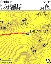
Context of comment:Currently MV provides GPS information in the form of waypoints that indicate the summit positions of all of the mountains in our list. While better than nothing this still does not use the full potential of GPS units . Essentially these can show maps and points of interest. There is no commercial product for GPS units at present, however we are pleased to announce the results of various community projects.
Message:Building on earlier work by member Pazapas and from data provided by the SMC (Scottish Mountaineering Club) briank has put together a really interesting article on what is available.
There is a link to the version produced by Pazapas and also links to other versions and other information. See Resources | All About maps for GPS in Ireland
Additional points:Getting the data onto your GPS requires the use of various tools and a PC, however it is perfectly feasible. We hope that this article will stimulate further interest in this area and also that we can find further sources of information to put onto maps. |
| Context of comment: (Show all posts) |
| Context of comment: (Show all posts) |
| Context of comment: (Show all posts) |
..
|
|
Summit Comment
Binnion: Tullagh Bay and Rockstown Harbour |
 Jim_Brady a day ago. Jim_Brady a day ago.
followed eejaymm's initial parking directions for Annagh except I didn 't take the lane beyond the fence and opted for a direct assaultafter parking at the dead end down to the left of his pa... |
|
|
Forum: General
Donations Drive, now finished. |
simon3 a day ago.
The donations drive that MV has been running for the last month is now complete for this year. The MV committee who receive the funds would like to express thanks to all who donated.Such don... |
|
Track
Good, relatively easy double bag |
 Colin Murphy 3 days ago. Colin Murphy 3 days ago.
Binbane and its sister hill Binbane NE are relatively easy summits to bag in a single walk and could also be comb... walk, Len: 3.9km, Climb: 317m, Area: An Bhinn Bhn, Bluestack Mountains (Irela|| |
|
|
Summit Summary
Crocknapeast: Long walk up windfarm roads. |
 Collaborative entry Last edit by: Colin Murphy 3 days ago. Collaborative entry Last edit by: Colin Murphy 3 days ago.
Crocknapeast is reached via a longish walk of about 13km return, mostly along windfarm tracks, and can be combined with a visit to Mulnanaff and Balbane Hill (unlisted) if you wish. There is ... |
|
|
Summit Summary
Mulnanaff: Longish walk up windfarm road. |
 Collaborative entry Last edit by: Colin Murphy 3 days ago. Collaborative entry Last edit by: Colin Murphy 3 days ago.
Mulnanaff is reached via a longish walk of about 10km return, mostly along windfarm tracks. There is parking for a couple of cars at a forestry entrance at G70138 81131. Cross over gate and w... |
|
Track
Lake District: Dale Head Horseshoe |
Onzy 6 days ago.
Round taking in 5 Wainwrights - Maiden Moor, High Spy, Dale Head, Hindscarth and Robinson. The standard round ... walk, Len: 16.1km, Climb: 1057m, Area: Maiden Moor, Lake District - Central & |... |
|
|
Track
Double bag mostly on windfarm tracks. |
 Colin Murphy 3 days ago. Colin Murphy 3 days ago.
I had hoped to make this a 3-bagged-tops outing but unfortunately I couldn’t find a way up Croaghacullin that did... walk, Len: 13.8km, Climb: 569m, Area: Crocknapeast, Donegal SW (Ireland) Croc|| |
|
|
Summit Summary
Binbane NE Top: Simple bag from its neighbouring top. |
 Collaborative entry Last edit by: Colin Murphy 3 days ago. Collaborative entry Last edit by: Colin Murphy 3 days ago.
See Binbane summary for initial approach. From Binbane this top is a mere 600m. Head directly east, dropping down to about 400m elevation at the col, which is spotted with a few small pools. ... |
|
Track
Lake District: Coledale Horseshoe |
Onzy 6 days ago.
Classic Coledale taking in 5 Wainwrights - Grisedale Pike, Crag Hill, Sail, Outerside and Barrow. I was able t... walk, Len: 16.7km, Climb: 1202m, Area: Grisedale Pike, Lake District - Central|... |
|
|
Summit Summary
Binbane: Steepish approach to relatively easy Carn. |
 Collaborative entry Last edit by: Colin Murphy 3 days ago. Collaborative entry Last edit by: Colin Murphy 3 days ago.
Binbane and Binbane NE can be reach relatively easily from a forest entrance just off the Bluestack Way. Take the minor road north just off the R262 and follow it until you reach a gate, whic... |
|
|
Summit Comment
Crucknaree: Magnificent views! |
 paddyhillsbagger 4 days ago. paddyhillsbagger 4 days ago.
Picking herself up at Knock Airport allowed a spot of hill bagging.There were a lot of small brown moths flying around the rather steep & rough heather on Crucknaree.Eventually managed to pho... |
|
..


