Guestuser: Login or enrol?
- Home
- Main Display
- Main Display NEW
- Find a Walk
- Display INTRODUCTION
- Donate to MountainViews
- Click below for your profile
guestuserWelcome to MountainViews
If you want to use the website often please enrol (quick and free) at top right.OverviewFor more map options click on any overview map area or any detail map feature.Detail Map FeaturesShowing 1 items:
Cnoc an da Chinn 391m,Find Suggested Walks
Find hill, mountain, island, coastal feature.Videos
 Recent Contributions
 Get Notifications
Glenbeigh Horseshoe
Spinans Hill: Access issue
Mad in Madeira
Spinans Hill: Access via a track from the north
Mournes: Ramble to Doan from Silent Valley
Croaghonagh: Another access problem?
Hellfire Club: Popular and well-loved amenity
Double Carn track with some rough terrain
Cloghmeen Hill: Gives access to a splendid ridge.
Mournes: All the Binnians from Silent Valley
Crockuna: Pretty easy but rewarding Carn
Ramble west of Clifden
Conditions and Info
Use of MountainViews is governed by conditions and a privacy policy.
Read general information about the site.
Opinions in material here are not necessarily endorsed by MountainViews.
Hillwalking is a risk sport. Information in comments, walks, shared GPS tracks or about starting places may not be accurate for example as regards safety or access permission. You are responsible for your safety and your permission to walk.
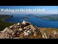
See the credits and list definitions.Video displayMull and Nearby Islands Area Mull SubareaPlace count in area: 72,
Highest place: Ben More, 966m
Maximum height for area: 966 metres, Maximum prominence for area: 966 metres,
Places in area Mull and Nearby Islands:
Gometra:Gometra 155m
Iona:Dun I 101m
Lunga (Treshnish Isles):Cruachan 103m
Mull:'S Airde Beinn 295mA'Chioch 867mA'Mhaol Mhor 433mAn Cruachan 581mBearraich 432mBeinn a'Chaol-airigh 127mBeinn a'Ghraig 591mBeinn a'Ghraig West Top 530mBeinn a'Mheadhoin [Beinn a'Mheadhain] 602.7mBeinn Bheag 537mBeinn Bhearnach 633mBeinn Bhuidhe 413mBeinn Charsaig 449mBeinn Chreagach 378.6mBeinn Chreagach Mhor 579mBeinn Chreagach Mhor East Top 569mBeinn Fhada 501mBeinn Fhada 702mBeinn Fhada NW Top 563mBeinn Mheadhon [Beinn Mheadhan] 637mBeinn na Croise 503mBeinn na Drise 424mBeinn na Duatharach 456mBeinn na Sreine 521mBeinn nam Feannag 466mBeinn nan Gabhar 572mBeinn nan Gobhar 436mBeinn Talaidh 761.7mBeinn Thunicaraidh [Beinn Thunacaraidh] 648mBen Buie 717mBen More 966mCarn Ban 248mCarn Mor 343.1mCnap nan Gobhar 714mCnoc an da Chinn 391mCoirc Bheinn 561mCorra-bheinn 704.9mCreach Beinn 698mCreach Bheinn 491.7mCreachan Mor 331mCruach Ardura 217.7mCruach Choireadail 618mCruach Inagairt 416mCruach nan Con 496mCruach Sleibhe 166mCruach Torr an Lochain 347.7mCruachan Beag 600.9mCruachan Beag 596mCruachan Dearg 704.1mCruachan Min 376mDruim Fada 405mDun da Ghaoithe 766mFionna Mham 494mGlas Bheinn 492mMainnir nam Fiadh 757mMaol a'Ghearraidh 522mMaol Ban 338.5mMaol Buidhe 599.7mMaol Mheadhonach 482mMaol Mheadhonach 476mMeall nan Capull 402mSgulan Beag 538mSgulan Mor 544mSgurr Dearg 741mSpeinne Mor 446mTom nam Fitheach 275.4mTorr a'Ghoai 434mTorr na h-Uamha 417m
Ulva:Beinn Chreagach 313m
Note: this list of places includes island features such as summits, but not islands as such.
Height: 391m OS 1:50k Mapsheet: 47 48 Grid Reference: NM44075 45057
Place visited by 2 members. Recently by: rhw, chalkyI have visited this place: NO (You need to be a logged-in member to change this.)Longitude: -6.163227, Latitude: 56.527628 , Easting: 144075, Northing: 745057 Prominence: 105m, Isolation: 4.2km , GPS IDs, 6 char: Cnc391, 10 char: CncandChn
Linkback: https://mountainviews.ie/summit/B4810/COMMENTS for Cnoc an da Chinn 1 of 1  Follow this place's comments


MountainViews.ie, a Hill-walking Website for the island of Ireland. 2400 Summiteers, 1480 Contributors, maintainer of lists: Arderins, Vandeleur-Lynams, Highest Hundred, County Highpoints etc

 Colin Murphy
 mcrtchly
 Collaborative entry
 Colin Murphy
 hibby
hibby
 Colin Murphy
 Collaborative entry
 Collaborative entry
 Visit our Facebook page.
