Welcome to MountainViews
If you want to use the website often please enrol (quick and free) at top right.
If you want to use the website often please enrol (quick and free) at top right.
Overview

For more map options click on any overview map area or any detail map feature.
Detail Map Features
Find Suggested Walks
Find hill, mountain, island, coastal feature.
Videos

Recent Contributions
 Get Notifications
Get Notifications
Longish walk to isolated top
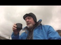
 Colin Murphy
More EastWest names added for summits.
Crocknasharragh: Impressive views on initial ascent.
 Colin Murphy
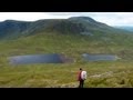
Ascending the Knockbrinneas from the north.
 simon3
Cunnigar: Short trek to summit
 Fergalh
Westtown Hill: Tramore's Highest Point
 DeirdreM
Lobawn Loop - Clockwise avoids any steep ascent! Easy stream crossing.
Knockbrinnea West Top: Eflanagan on the Knockbrinneas
 eflanaga
Walk on tracks above Glendalough
 ceadeile
Knockbrinnea West Top: Larger Twin
 Collaborative entry
Knockaunanattin West Top: Views, loughs and a navigational aid.
 simon3
Circumnavigation of Tawny Rower
 glencree
Conditions and Info
Use of MountainViews is governed by conditions and a privacy policy.
Read general information about the site.
Opinions in material here are not necessarily endorsed by MountainViews.
Hillwalking is a risk sport. Information in comments, walks, shared GPS tracks or about starting places may not be accurate for example as regards safety or access permission. You are responsible for your safety and your permission to walk.
See the credits and list definitions.
 Visit our Facebook page.
Suggested Walks Starting on the detail map above. Hopefully useful.
Choose type(s)
Important Note: Walks presented here are members shared tracks shown in the hope that they may be useful to you but with no guarantee. You need to determine whether any given track is appropriate for you and your party as per these conditions.
Video display
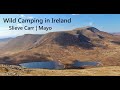
Nephin Begs
Area NW: Slieve Carr Subarea
Place count in area: 28,
OSI/LPS Maps: 22, 23, 30, 31, CBW, EW-ACC, EW-WNN, EW-WNS
Highest place: Slieve Carr, 721m
Maximum height for area: 721 metres,
Maximum prominence for area: 646 metres,
Places in area Nephin Begs:
Cen: Glennamong:Bengorm 582mBengorm NW Top 468mCorranabinnia 716mCorranabinnia SW Top 687mGlennamong 628mGlennamong East Top 415mTirkslieve 401m
Cen: Nephin Beg:Aroher Hill 285mLettertrask 279mNephin Beg 627mNephin Beg South Top 410m
E: Birreencorragh:Birreencorragh 698mBirreencorragh South Top 564mBirreencorragh West Top 551mBuckoogh 588mBullaunmore 388mKnockaffertagh 517mMount Eagle 427mSrahmore 186mSrahrevagh North 282m
NW: Slieve Carr:Bunmore 243mSheeanmore 282mSlieve Alp 329mSlieve Carr 721mTawnyanruddia 531m
SW: Maunthomas:Claggan Mountain NE Top 501mMaumthomas NE Top 440mMaumthomas SW Top 477m
Note: this list of places includes island features such as summits, but not islands as such.
Highest place:
Slieve Carr, 721mPlaces in area Nephin Begs:
Cen: Glennamong:
Bengorm 582mBengorm NW Top 468mCorranabinnia 716mCorranabinnia SW Top 687mGlennamong 628mGlennamong East Top 415mTirkslieve 401mCen: Nephin Beg:
Aroher Hill 285mLettertrask 279mNephin Beg 627mNephin Beg South Top 410mE: Birreencorragh:
Birreencorragh 698mBirreencorragh South Top 564mBirreencorragh West Top 551mBuckoogh 588mBullaunmore 388mKnockaffertagh 517mMount Eagle 427mSrahmore 186mSrahrevagh North 282mNW: Slieve Carr:
Bunmore 243mSheeanmore 282mSlieve Alp 329mSlieve Carr 721mTawnyanruddia 531mSW: Maunthomas:
Claggan Mountain NE Top 501mMaumthomas NE Top 440mMaumthomas SW Top 477mNote: this list of places includes island features such as summits, but not islands as such.

Bedrock type: Banded, graded and X-bedded quartzites., (Bangor/Corslieve Formation)
Also known as Slieve Cor or Corslieve. The Discovery map links the name Corslieve with a neighbouring peak (541m) situated about 3 miles to the south, but the Ordnance Survey Name Book and William Bald's map of Mayo (1830) show quite clearly that it is simply an alternative for Slieve Carr, with the same elements inverted. A cairn on the summit is named Laghtdauhybaun on the old ½ inch map, but is unnamed on the Discovery map. This is probably derived from Ir. Leacht Dáithí Bháin, 'burial monument of white Dáithí'. There may be a connection with Dáithí, a king of Connacht and reputed last pagan high-king of Ireland (see Slieve Alp). This peak is named Curslieve on Bald’s map of Mayo (1830). Slieve Carr is the highest mountain in the Nephin Begs area and the 97th highest in Ireland. Slieve Carr is the most northerly summit in the Nephin Begs area.
Linkback: https://mountainviews.ie/summit/94/
COMMENTS for Slieve Carr (Corrshliabh) 1 2 3 4 5 Next page >>  Follow this place's comments

|
|
|
|
||
| MountainViews.ie, a Hill-walking Website for the island of Ireland. 2400 Summiteers, 1480 Contributors, maintainer of lists: Arderins, Vandeleur-Lynams, Highest Hundred, County Highpoints etc | |||