If you want to use the website often please enrol (quick and free) at top right.

 Get Notifications
Knockatee: Short but unpleasant hill
 Collaborative entry
Challenging enough loop walk with wonderful views.
 Colin Murphy
Beann Bhán: Passage tomb?
 Colin Murphy
Tough enough Carn with very fine views
 Colin Murphy
Ben Goram: Up pilgram path to reek then west down via ridge. hot sun, cloud inve
Crott Mountain, near Croagh Patrick, now demo
 simon3
Croagh Patrick: Up pilgram path to reek then west down via ridge Ben Goram. hot
 gaoithe
Good tracks to two Carns.
 Colin Murphy
Knocknagullion: Relatively challenging climb with great views.
 Collaborative entry
A visit to Tievummera via its South East spur.
 simon3
Nowen Hill Far West Top: Previous access issue to this simple stroll seems to ha
 Colin Murphy
Minaun: Towards Keem
 magnumpig
Use of MountainViews is governed by conditions and a privacy policy.
Read general information about the site.
Opinions in material here are not necessarily endorsed by MountainViews.
Hillwalking is a risk sport. Information in comments, walks, shared GPS tracks or about starting places may not be accurate for example as regards safety or access permission. You are responsible for your safety and your permission to walk.
See the credits and list definitions.
 Visit our Facebook page.
 Length: 21.7km, Creator time taken: 9h17m, Ascent: 1461m,
Descent: 1465m
Places: Start at C2936339144, Mamore Hill, Crockmain, Raghtin More, Croaghcarragh, Urris Hills, end at Start
Logged as completed by 1

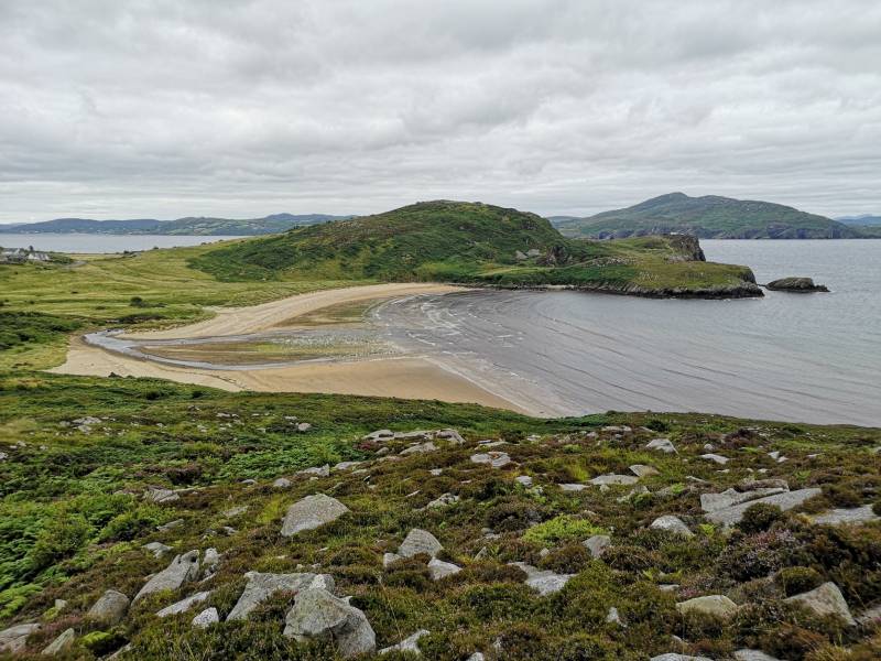
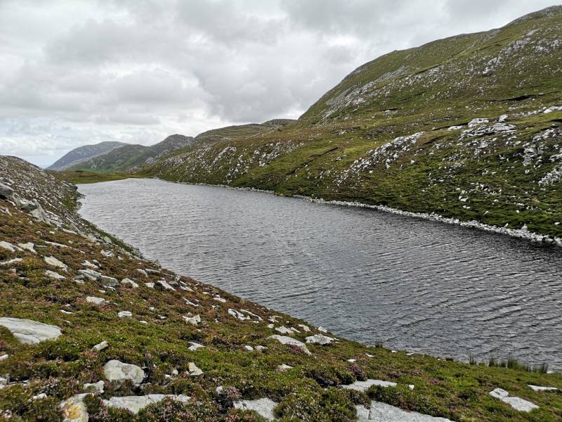
It was a steady climb through the short heather (buzzing with bees) up into the Urris Hills, with beautiful views over the beach and then Lough Swilly and the line of the Derryveagh Mtns. The walking is pretty easy and there is a well worn path between the rocks along the line of hills. I made a worthy detour to link with the Urris Lakes Loop Walk and pass Lough Fad and Crunlough. These are beautifully nestled little loughs and one of my first wild camping adventures was at lough Fad which seemed like the adventure of a lifetime (which it was at the time).
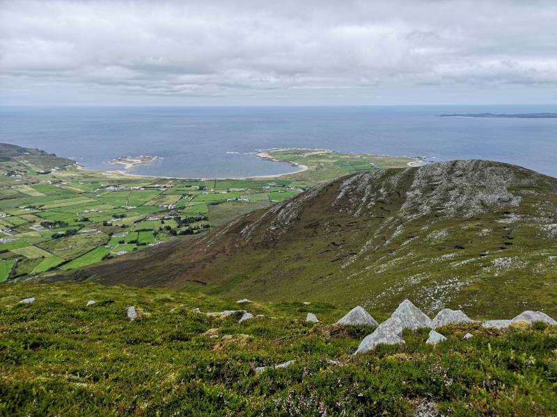
I was soon back up on the hill tops following the line of mini summits, which all look like mighty mountains (it is true!) with stunning views over the Inishowen coastline and a good part of Donegal - and to the Sperrins and Antrim Hills on this clear day. Croaghnagarragh was reached before the significant drop to the Gap of Mamore - a little bog road can be followed down to the road itself, It is a good viewpoint for the hills to some, leading up to the bulk of Ragtin More. I met my first people at the Gap, quite a few of them in fact. though they were soon left behind as I climbed up Mamore HIll. More fabulous views all the way as I passed its 2 little summits with cairns.
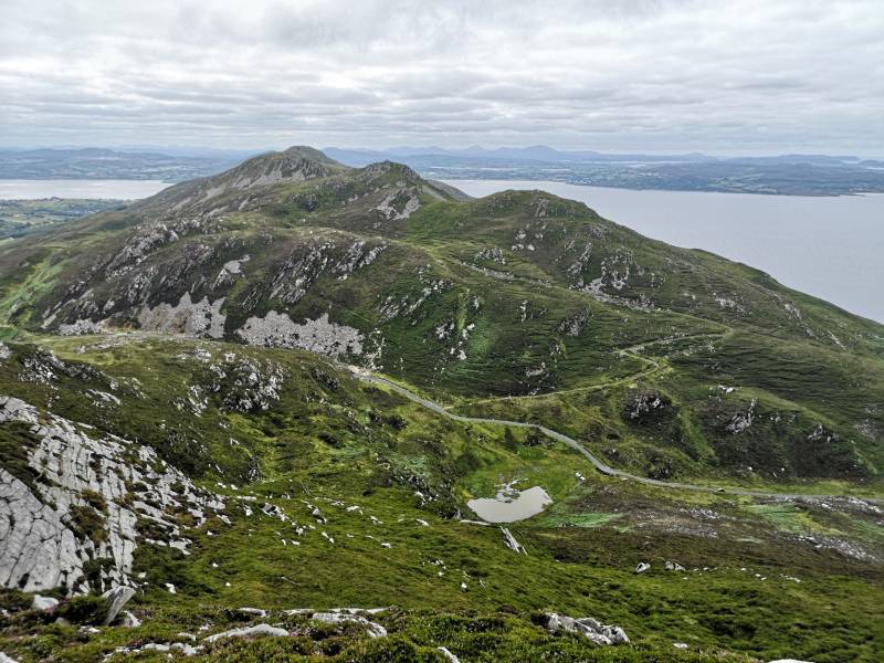
Another drop to the popular track coming up from the carpark which brings people to Crockmain and its bigger neighbour, Ragtin More. My drop was rather direct and a more leisurely descent would be to follow my return leg. I followed another old bog track for a bit and then up to the summit of Crockmain. A slight drop brings a little lough and then the fairly easy pull up Ragtin More. Met a group descending and then had the mountain to myself.
I think Ragtin More is pretty cool - it is very rocky and has a number of cairns built by those who couldnt resist all those stones lying around no doubt. The views over to Dunaff Head and the golden strands of sand delight no matter how many times they are viewed. The line of hills traversed is laid out like some magnificent painting of perfect hillscape pointing the way to the rest of Donegal and all the brilliance it has to offer.
It was now time to do it all over again and it didn't feel like a chore, it felt great. Rising and dropping all the way and taking in Urris at 471m that i had deliberatley missed when exploring the loughs. The beach was a welcome sight and it was much busier than it had been this morning. The trail shoes had managed well on the dry ground. These are some of those hills that you keep going back to time after time as they hold great memories and build new ones with each return. Well worth a visit!
NOTE: ALL information such as Ascent, Length and Creator time taken etc should be regarded as approximate. The creator's comments are opinions and may not be accurate or still correct.
Your time to complete will depend on your speed plus break time and your mode of transport. For walkers: Naismith's rule, an approximate though often inaccurate estimate, suggests a time of 6h 46m + time stopped for breaks
NOTE: It is up to you to ensure that your route is appropriate for you and your party to follow bearing in mind all factors such as safety, weather conditions, experience and access permission.
* Note: A GPS Height in the elevation profile is sourced from the device that recorded the track. An "SRTM" height is derived from a model of elevations for parts of the earth. More detail![]()
|
|
|
||
| MountainViews.ie, a Hill-walking Website for the island of Ireland. 2400 Summiteers, 1480 Contributors, maintainer of lists: Arderins, Vandeleur-Lynams, Highest Hundred, County Highpoints etc | |||