Members and Supporters, the MountainViews Committee requests your help to meet the costs of the website and of other activities such as insured events or publications.
jgfitz: Track/4029 in area near Dublin/Wicklow (Ireland)
Knocksink Wood to Glencullen and Stepaside
Ascent: 602m,
Length: 14.3km,
Creator time taken: 5h16m
Descent: 543m,
Time predicted from Naismith's rule: 3h 52m + breaks
Click here to rate track
PlacesStart at Enniskerry (EnnisK) O22080 17477, end at Kilgobbin Lane (KlGob) O19109 24072, 7.2km NW from Start
Track Rating ..
[RWD version 1 ]
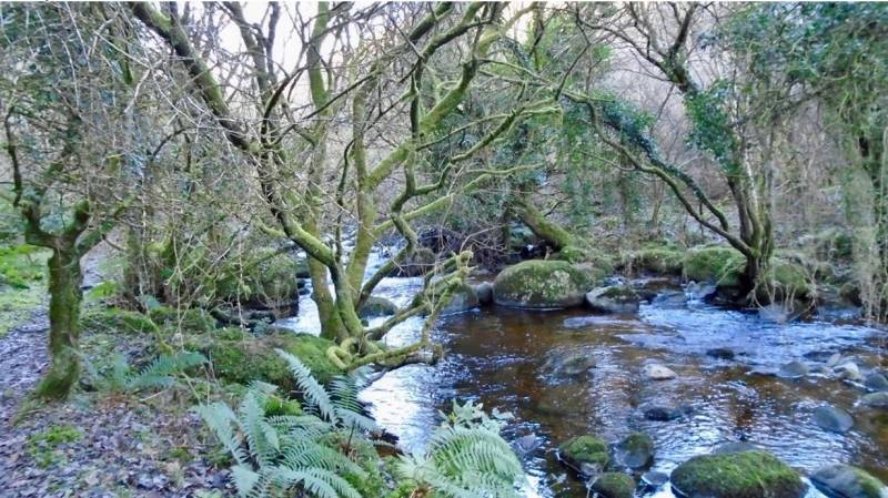
Knocksink Wood on the outskirts of Enniskerry is a lovely nature reserve. After an easy 2 km hiking, the remaining 2 km of this wood gets gradually more challenging. Make sure to take a left turn over the bridge across the Glencullen River, and continue upriver into the wood as the gorge deepens. The wood gets wild and wonderful. Eventually, as you ascend steeply towards the road and away from the river below, take good care as it can be slippery and dangerous in wet conditions. For the 1 km road from there to Glencullen, it is advisable to wear a yellow vest for safety reasons. Glencullen Activity Park (GAP) offers a welcome coffee on a cold day, and is the access point for a new off-road hiking trail around the former golf course and onwards towards Three Rock. On this occasion, we chose to turn east just before reaching Three Rock, descending to the road at Barnaculia, crossing it, and then down through Fernhill to emerge onto the Enniskerry Road and Stepaside. An excellent and very satisfying hike. (We were delayed at the beginning of the hike, so one would expect to complete it in perhaps 45 minutes less than it took us on this occasion).
Glencullen River within Knocksink Wood
Editing Details for track/4029
NOTE: ALL information such as Ascent, Length and Creator time taken etc should be regarded as approximate. The creator's comments are opinions and may not be accurate or still correct.
Your time to complete will depend on the speed of the slowest plus break time and your mode of transport.
NOTE: It is up to you to ensure that your route is appropriate for you and your party to follow bearing in mind all factors such as safety, weather conditions, experience and access permission.
Uploaded on: Thu, 17 Jan 2019 (22:05:56), Linkback: https://mountainviews.ie/track/4029/
* Note: A GPS Height in the elevation profile is sourced from the device that recorded the track. An "SRTM" height is derived from a model of elevations for parts of the earth. More detail
Use of MountainViews is governed by conditions and a privacy policy.
Read general information about the site. Opinions in material here are not necessarily endorsed by MountainViews.
Hillwalking is a risk sport. Information in comments, walks, shared GPS tracks or about starting places may
not be accurate for example as regards safety or access permission. You are responsible for your safety and your permission to walk.
See the credits and list definitions.


 Our Facebook page.