Members and Supporters, the MountainViews Committee requests your help to meet the costs of the website and of other activities such as insured events or publications.
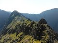
curus_lulus: Track/2142 in area near Caher West Top, MacGillycuddy's Reeks (Ireland)
Coomloughra Horseshoe counter-clockwise, very bad weather
Ascent: 1282m,
Length: 14.5km,
Creator time taken: 11h42m
Descent: 1248m,
Time predicted from Naismith's rule: 5h 3m + breaks
Click here to rate track
PlacesStart at Hydro Road CP (Hydro Rd) V77223 87119, Caher West Top, Caher, Carrauntoohil, The Bones Peak, Beenkeragh, Stumpa Bharr na hAbhann, Skregmore, Cnoc Íochtair, end at Start
Track Rating ..
[RWD version 1 ]
gale strength wind, white out, spending lot of time looking for caches especially at Caher West..
Editing Details for track/2142
NOTE: ALL information such as Ascent, Length and Creator time taken etc should be regarded as approximate. The creator's comments are opinions and may not be accurate or still correct.
Your time to complete will depend on the speed of the slowest plus break time and your mode of transport.
NOTE: It is up to you to ensure that your route is appropriate for you and your party to follow bearing in mind all factors such as safety, weather conditions, experience and access permission.
Uploaded on: Fri, 26 Apr 2013 (21:34:29), Linkback: https://mountainviews.ie/track/2142/
* Note: A GPS Height in the elevation profile is sourced from the device that recorded the track. An "SRTM" height is derived from a model of elevations for parts of the earth. More detail
Use of MountainViews is governed by conditions and a privacy policy.
Read general information about the site. Opinions in material here are not necessarily endorsed by MountainViews.
Hillwalking is a risk sport. Information in comments, walks, shared GPS tracks or about starting places may
not be accurate for example as regards safety or access permission. You are responsible for your safety and your permission to walk.
See the credits and list definitions.


 Our Facebook page.