Members and Supporters, the MountainViews Committee requests your help to meet the costs of the website and of other activities such as insured events or publications.
Feature count in area: 57, by county: Cork: 32, Kerry: 36, of which 11 are in both Cork and Kerry,
OSI/LPS Maps: 83, 84, 85, 88
Highest Place: Hungry Hill 682m
Starting Places (51) in area Caha Mountains: Ardgroom, Barley Lake North, Bere Island Pier, Caha Pass, Canshanavoe South, Carriganine, Cashelkeelty Stone Circles Carpark, Castletownbere Lifeboat Harbour, Clashduff River Farm, Coolieragh Harbour Road, Coomadayallig Lake Road N, Coomadayallig Lake Road S, Cooryeen Lane, Cummer Lough East Road, Derreenataggart Stone Circle Road, Dromoghty Lough North, Dunboy Wood, Esk Boreen, Eyeries, Fehanah Lane, Garinish Island Pier, Glantrasna Bridge, Glenbeg Lough N, Glengarriff, Glengarriff Nature Reserve CP, Gleninchaquin Waterfall, Gowlaun Lough, Healy Pass, Healy Pass Hairpin, Ilnacullin Car Park, Kenmare Bridge, Knockacullin Lane, Leahill Bog, Leitrim Beg Standing Stone, Lough Inchiquin SE, Magannagan Stream, Molly Gallivan's Visitor Centre, Nora's Cottage, Old Lansdowne School, Owgarriff River Lane, Peg's Shop, Pooleen Wood Car Park, Red Trout Lake, Reenroe Bridge, River Drimminboy Track, Rossmackowen Bridge, Rossmackowen Cemetery, Shronebirrane Farm, Shronebirrane Road, Toberbanaha, Turner's Rock Tunnel
Summits & other features in area Caha Mountains: Cen: Hungry Hill: Coombane 510m, Derryclancy 554m, Hungry Hill 682m Cen: Knockowen: Cushnaficulla 594m, Glenkeel Top 417m, Knockastumpa 398m, Knockeirky 577m, Knockeirky South Top 523m, Knockowen 658m, Stookeennalackareha 412m E: Glengarriff: Derrynafulla SW 375m, Gowlbeg Mountain 362m, Nareera 530m, Nareera North Top 503m, Nareera South-West Top 505m, Shrone Hill 283m, Sugarloaf Mountain 574m, Sugarloaf Mountain Far West Top 560m, Sugarloaf Mountain West Top 565m N: Coomnadiha: Baurearagh Mountain 489m, Caha Far SE Top 555m, Caha SE Top 585m, Coomnadiha 644m, Coomnalack Top 435m, Cummeenbaun 510m, Droppa 522m, Killane Mountain 537m, Killane Mountain South-West Top 533m, Knockagarrane 414m, Knockreagh 500m N: Knockeirka: Barraduff Mountain 400m, Killaha Mountain 400m, Knockeirka 426m N: Knocknagorraveela: Derrysallagh 410m, Feorus East 474m, Knocknagorraveela 507m, Knocknagorraveela NE Top 464m N: Lauragh: Knockanoughanish 386m, Knockatee 330m S: Castletownbere: Disert 205m, Knockanallig (Bear Island) 267m W: Ardgroom: Derryvour Hill 160m W: Eskatarriff: Coomacloghane 599m, Eskatarriff 600.5m, Eskatarriff East Top 532.7m, Knocknaveacal North Top 509.1m, Knocknaveacal South Top 507.2m, Lackabane 603m, Tooreenbaha 408.7m, Tooreennamna 524m, Tooth Mountain 592m W: Knocknagree: Knocknagree 586m, Knocknagree East Top 461m, Knocknagree SE Top 442m, Lackawee 572m, Maulin 621m, Maulin North Top 579m
Note: this list of places may include island features such as summits, but not
islands as such.
Barraduff Mountain, 400mHill Cnoc Bharr Dubh A name in Irish,
Place Rating ..
(Ir. Cnoc Bharr Dubh [OSI], 'hill of Barr Dubh or black top'), Kerry County in Munster province, in Carn Lists, Barraduff Mountain is the 957th highest place in Ireland.
Grid Reference V90847 65609,
OS 1:50k mapsheet 85 Place visited by: 29members, recently by: maoris, Superterence, learykid, eamonoc, Colin Murphy, John.geary, chelman7, Taisce, Fergalh, Bernieor, madfrankie, daitho9, pdelacy, shaunkelly, ciarraioch
I visited this place: NO (You need to be a logged-in member for this.)
Short or GPS IDs, 6 char: BrdfMn, 10 char: BrdfMntn Linkback: https://mountainviews.ie/summit/832/
Gallery for Barraduff Mountain (Cnoc Bharr Dubh) and surrounds
Summary
for Barraduff Mountain (Cnoc Bharr Dubh):
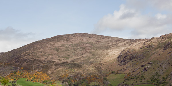
Approach from the south west.
Summary created by Colin Murphy
2022-03-30 13:46:07
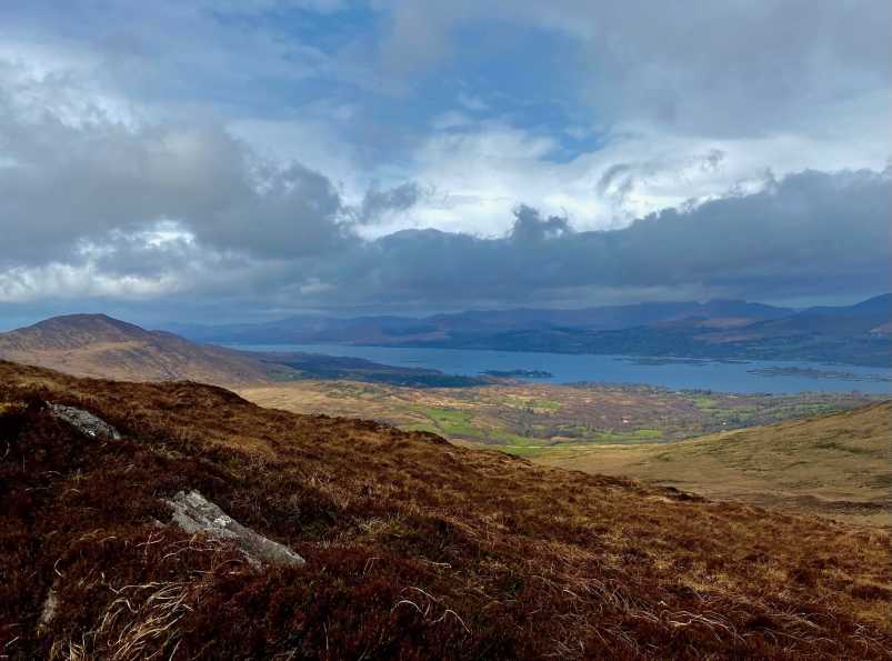
Picture: Kenmare Bay from the summit.
One approach is starting from Cummer L (Cummer L (V896 635)), where there is just about parking for 2 cars. Just behind the parking spot a narrow trail starts in a NE direction and continues on and off until Castle Rock, which is a prominent rise and appears almost to be a separate top. After this you continue in a northerly direction across a flattish, occasionally boggy col, losing about 80m in height before ascending again, the last 300m or so becoming quite steep. The summit is unmarked but offers great views of Kenmare Bay and the surrounding hills. Return journey to car about 7km, taking about 2 hours.
One way of accessing this summit and the other two hills in the area (Knockeirka and Killaha) is to start from where a narrow public road reaches its highest point at around Cummer L (Cummer L (V896 635)). There is a small amount of parking here and access onto the open hillside in such a way that it is unlikely to cause any difficulty with landowners. Linkback: mountainviews.ie/summit/832/comment/6319/
Read Less
Read More
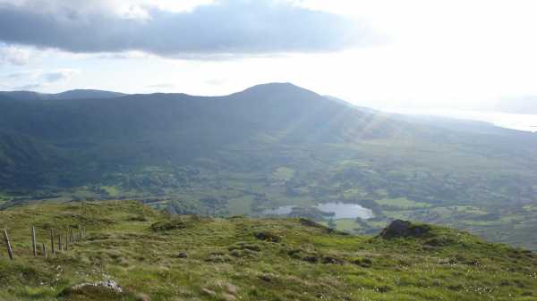
Picture: Looking down on Dromoughty from Barraduff
3 summits, 2 hours, 1 beautiful location
by Conor74
12 Jun 2010
Took this in as part of a circuit including Knockeirka and Killaha Mountain. See former for details of parking and ascent of that summit. At the top of Knockeirka, turned west south west and the route to Barraduff is easily visible on a clear day. In cloud or mist simply stay near the wire and post fence that runs from one summit to the other. Warning - this is met by a number of other fences along the way, though all relatively easy to get over. Going was very straightforward, perhaps gaiters useful at wetter times as we walked it in a very dry spell and even still had to skirt the odd boggy patch. The walk itself is lengthy enough, between 2 and 3 km, but fast going, took about 35 minutes to cross from Knockeirka to Barraduff. A short pull up at the end for about 50m, but very straightforward and rewarded with fine views over Dromoughty and down the Kenmare Bay. The summit is featureless, no cairns. Lovely area though, very remote feel to it. From there we moved on to Killaha Mountain, which again was easy to pick out on a clear day, and again a fence runs between the two which might be convenient in poorer visibility.
WARNING - (i) All 3 mountains contain a lot of fences for a good reason. Lots of sheep. This really is no place for a dog. At all. And (ii) the 2 hours was really for headline purposes, it took us about 2 hours 20 mins overall from car back to car, and we walked pretty fast, so allow a bit more time... Linkback: mountainviews.ie/summit/832/comment/5869/
Read Less
Read More
Alternative route for Barraduff Mtn
by three5four0
9 Oct 2011
Parked at Simons previously mentioned spot at Cummer L (V896 635) and followed sheep tracks up the ridge, behind the parking spot (more like a bay cut out of the slope), to Caste Rock. On the summit area of Castle Rock there is a fence junction, with one fence descending northwards, follow this into the col, pass the standing stone and climb the slopes of Barraduff Mountain. We continued on and took in the other 2 MV summits, giving around of 13.9 km in about 3 hours 45 min. Linkback: mountainviews.ie/summit/832/comment/6579/
Use of MountainViews is governed by conditions and a privacy policy.
Read general information about the site. Opinions in material here are not necessarily endorsed by MountainViews.
Hillwalking is a risk sport. Information in comments, walks, shared GPS tracks or about starting places may
not be accurate for example as regards safety or access permission. You are responsible for your safety and your permission to walk.
See the credits and list definitions.


 Our Facebook page.