Members and Supporters, the MountainViews Committee requests your help to meet the costs of the website and of other activities such as insured events or publications.
Feature count in area: 57, by county: Cork: 32, Kerry: 36, of which 11 are in both Cork and Kerry,
OSI/LPS Maps: 83, 84, 85, 88
Highest Place: Hungry Hill 682m
Starting Places (51) in area Caha Mountains: Ardgroom, Barley Lake North, Bere Island Pier, Caha Pass, Canshanavoe South, Carriganine, Cashelkeelty Stone Circles Carpark, Castletownbere Lifeboat Harbour, Clashduff River Farm, Coolieragh Harbour Road, Coomadayallig Lake Road N, Coomadayallig Lake Road S, Cooryeen Lane, Cummer Lough East Road, Derreenataggart Stone Circle Road, Dromoghty Lough North, Dunboy Wood, Esk Boreen, Eyeries, Fehanah Lane, Garinish Island Pier, Glantrasna Bridge, Glenbeg Lough N, Glengarriff, Glengarriff Nature Reserve CP, Gleninchaquin Waterfall, Gowlaun Lough, Healy Pass, Healy Pass Hairpin, Ilnacullin Car Park, Kenmare Bridge, Knockacullin Lane, Leahill Bog, Leitrim Beg Standing Stone, Lough Inchiquin SE, Magannagan Stream, Molly Gallivan's Visitor Centre, Nora's Cottage, Old Lansdowne School, Owgarriff River Lane, Peg's Shop, Pooleen Wood Car Park, Red Trout Lake, Reenroe Bridge, River Drimminboy Track, Rossmackowen Bridge, Rossmackowen Cemetery, Shronebirrane Farm, Shronebirrane Road, Toberbanaha, Turner's Rock Tunnel
Summits & other features in area Caha Mountains: Cen: Hungry Hill: Coombane 510m, Derryclancy 554m, Hungry Hill 682m Cen: Knockowen: Cushnaficulla 594m, Glenkeel Top 417m, Knockastumpa 398m, Knockeirky 577m, Knockeirky South Top 523m, Knockowen 658m, Stookeennalackareha 412m E: Glengarriff: Derrynafulla SW 375m, Gowlbeg Mountain 362m, Nareera 530m, Nareera North Top 503m, Nareera South-West Top 505m, Shrone Hill 283m, Sugarloaf Mountain 574m, Sugarloaf Mountain Far West Top 560m, Sugarloaf Mountain West Top 565m N: Coomnadiha: Baurearagh Mountain 489m, Caha Far SE Top 555m, Caha SE Top 585m, Coomnadiha 644m, Coomnalack Top 435m, Cummeenbaun 510m, Droppa 522m, Killane Mountain 537m, Killane Mountain South-West Top 533m, Knockagarrane 414m, Knockreagh 500m N: Knockeirka: Barraduff Mountain 400m, Killaha Mountain 400m, Knockeirka 426m N: Knocknagorraveela: Derrysallagh 410m, Feorus East 474m, Knocknagorraveela 507m, Knocknagorraveela NE Top 464m N: Lauragh: Knockanoughanish 386m, Knockatee 330m S: Castletownbere: Disert 205m, Knockanallig (Bear Island) 267m W: Ardgroom: Derryvour Hill 160m W: Eskatarriff: Coomacloghane 599m, Eskatarriff 600.5m, Eskatarriff East Top 532.7m, Knocknaveacal North Top 509.1m, Knocknaveacal South Top 507.2m, Lackabane 603m, Tooreenbaha 408.7m, Tooreennamna 524m, Tooth Mountain 592m W: Knocknagree: Knocknagree 586m, Knocknagree East Top 461m, Knocknagree SE Top 442m, Lackawee 572m, Maulin 621m, Maulin North Top 579m
Note: this list of places may include island features such as summits, but not
islands as such.
Knockagarrane, 414mHill Cnoc an Ghearráin A name in Irish,
Place Rating ..
Ir. Cnoc an Gharráin [T6000], 'hill of the grove’, Kerry County in Munster province, in Carn Lists, Knockagarrane is the 883rd highest place in Ireland.
Grid Reference V81800 62400,
OS 1:50k mapsheet 84 Place visited by: 31members, recently by: maoris, Superterence, Grumbler, learykid, Colin Murphy, annem, chelman7, wicklore, daitho9, hivisibility, Fergalh, Wildrover, eamonoc, conormcbandon, PeakPaul
I visited this place: NO (You need to be a logged-in member for this.)
Longitude: -9.714239, Latitude: 51.801939, Easting: 81800, Northing: 62400,
Prominence: 59m, Isolation: 1.4km ITM: 481776 562464 Bedrock type: Purple & green sandstone & siltstone, (Caha Mountain Formation) Notes on name: This northern shoulder of Knockreagh overlooks Lough Inchiquin and the Cloonee Loughs.
Short or GPS IDs, 6 char: Knckgr, 10 char: Knckgrn Linkback: https://mountainviews.ie/summit/763/
Gallery for Knockagarrane (Cnoc an Ghearráin) and surrounds
Summary
for Knockagarrane (Cnoc an Ghearráin):
Not high but what views
Summary created by Colin Murphy, thomas_g
2022-06-20 14:17:28
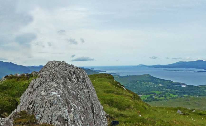
Picture: Summit with view of Kenmare Bay
Best starting point is from A (V82936 63608), where there is room to park for a couple of cars. Go through the gate following the Beara Way south-east. This first section seems to be through private farmland (although there is no issue with access) with a number of historic attractions such as the Uragh Stone Circle and a famine-era house, and there is box with a suggested donation of €1. Leave an extra half hour if you plan to visit these. Continue up the meandering track, which is in a bad condition in parts, the incline quite steep in places. The trail is wayarked and features stiles. When you reach B (V81684 62589), turn SE, cross a barbed wire fence and begin to ascend the steep final part of the hill, zig zagging around large rocky outcrops and grassy terrain. you will ascend about 180m in the final 300m, so it is very steep in parts, but quite doable. The summit is a prominent, elongated outcrop.
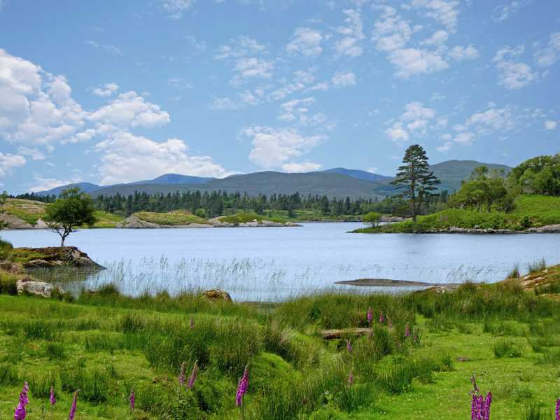
Picture: Cloonee Lough Upper from near the starting point.
Small but beautiful
by Colin Murphy
20 Jun 2022
Despite the fact that it's merely a Carn, Knockagarrane is quite the hill in terms of the challenge, the ruggedness of its upper slopes and the tremendous panoramas it offers. The starting point is only a little above sea level so expect a climb of almost 400m. As you ascend the views over Cloonee Lough Upper and Lough Inchiquin are terrific and the last stretch offers you a look at Kenmare Bay in its entirety. A very worthwhile little hill indeed. Linkback: mountainviews.ie/summit/763/comment/23560/
Use of MountainViews is governed by conditions and a privacy policy.
Read general information about the site. Opinions in material here are not necessarily endorsed by MountainViews.
Hillwalking is a risk sport. Information in comments, walks, shared GPS tracks or about starting places may
not be accurate for example as regards safety or access permission. You are responsible for your safety and your permission to walk.
See the credits and list definitions.


 Our Facebook page.