Members and Supporters, the MountainViews Committee requests your help to meet the costs of the website and of other activities such as insured events or publications.
Feature count in area: 115, by county: Wicklow: 108, Kildare: 4, Wexford: 2, Carlow: 3, of which 1 is in both Wexford and Wicklow, of which 1 is in both Carlow and Wicklow,
OSI/LPS Maps: 28B, 55, 56, 61, 62, AWW, EW-DM, EW-LG, EW-WE, EW-WS
Highest Place: Lugnaquilla 924.7m
Starting Places (205) in area Wicklow: 1916 Memorial Car Park, Aghavannagh Ow Bridge, Aghowle Wood, Altidore Wood Entrance, Annacurra National School, Annalecka Bridge, Asbawn Brook L8350, Aughrim National School, Ballard Road, Ballinabarny Gap, Ballinagappoge Bridge Layby, Ballinagappoge Mountain Hairpin, Ballinagore, Ballinahinch Wood, Ballinastoe MBT CP, Ballinastraw South, Ballineddan Upr Fork, Ballinfoyle Upr Cross, Ballycoog, Ballycreen Brook Bridge, Ballycumber, Ballycumber Bridge, Ballycumber Lane, Ballycumber Wicklow Way, Ballylerane, Ballylow Bridge, Ballylusk Quarry, Ballymanus Lane, Ballymoyle Shooting Lodge, Ballynultagh Gap, Ballynultagh Lane, Ballyreagh Wood, Ballyross Forest, Ballysmuttan Long Stone, Baravore, Barnbawn South, Barranisky North, Barranisky West, Bohilla Land Roundabout, Bohilla Lane Mid, Boranaraltry Bridge, Bray Harbour, Brewel West, Brittas Bay North CP, Buckroney Sand Dunes CP, Bus Terminus, Camera Hill Track Cross, Castletimon Wood North, Clara Vale, Clone House Road, Clonegal, Cloon Wood Cp, Coate Bridge, Coolballintaggart Ledge, Coolbawn House Lane, Cransillagh Brook , Crone Wood CP, Crossbridge, Crossoona Rath, Cummer Wood South, Curtlestown Wood CP, Deputy's Pass CP, Derralossary Church, Derry River Bridge, Devil's Glen CP, Devil's Glen Wood, Djouce Wood Calary, Djouce Wood Lake, Djouce Wood Long Hill, Donard, Donnelly's Lane Car Sales, Drumgoff Forest, Dunranhill North, Dunranhill SE, Dunranhill South, Dwyer McAllister Cottage CP, Enniskerry, Fentons Pub, Fitzsimons Park GAA, unuseableFlemings Footbridge Glen Rd, Gap Pub, Gap Road, Glen Beach CP, Glen of the Downs CP, Glenbride Lane, Glenbride Lodge, Glencree Reconciliation, Glendalough, Glenealy GAA, Glenmacnass Tonelagee CP, Glenmalure Hostel, Glenmalure Lodge, Glenmalure Waterfall, Glenview Hotel, Gowle House, Great Sugar Loaf CP, Grove Bar, Heffernans Well Wood, Hill View, Hollywood Glen, JB Malone CP, Johnnie Fox Pub, Keadeen NE trail, Keadeen Trailhead, Kevins Way Footbridge, Kilbride Army Camp Entrance, Kilcandra South, Kilcommon View, Killalongford Wood, Kilmacrea Cross Roads, Kilranelagh House Gate, Kilruddery Car Park, Kilruddery Cottages, Kings River, Kippure Bridge, Kippure Estate, Kippure Transmitter Gate, Knickeen Cross, Knocknaboley Lane Leeraghs Bog, Knocknaboley Lane Stone Cottage, Knockrath Little, Knockree west, Kyle Loop North, Lackan Wood S, Lake Dr Fraughan Brook, Lake Drive, Lake Park Cross, Lake View Pub, Laragh Free Car Park, Laragh NSch, Lead Mines CP, Liffey Bridge, Liffey Head Bridge, Lough Bray Lower, Lough Bray Upper, Lough Tay North Viewing Point, Lough Tay Wicklow Way CP, Luglass Lane L97561, Lugnagun Track, Macreddin Village, Mangans Lane, Military Road Carrigshouk Hill, Military Road Inchavore River Nth, Military Road Inchavore River Sth, Military Road NW Lough Tay, Military Road Ballyboy Bridge, Military Road Cloghoge Brook, Military Road Croaghanmoira, Military Road Fananierin, Military Road LaraghWicklow Way, Military Road Slieve Maan, Monspolien Bridge, Moortown House, Mountain Rescue HQ, Muskeagh Little Wood, Nahanagan Lough NE, Novara Avenue, Bray, Oiltiagh Brook Knickeen, Old Bridge Cross, Old Bridge Scouts , Old Wicklow Way entrance, Paddock Hill SE, Pier Gates CP, Powerscourt Waterfall CP, Putland Road, Quintagh East, Raheen Park CP, Raheenleagh East, Railway Walk CP, Rathdrum Railway Station, Rednagh Wood, Rocky Valley, Roundwood, Sally Gap, Sally Gap N, Seefin Trailhead, Seskin SE, Shankill Tributary Bridge, Shay Elliott, Sheepshanks Bridge, Shillelagh, Slievecorragh Track, Slievefoore South, Sraghoe Brook, St John's Church, St Kevins Chair, St Kevins Church, St Kevins Way R756, Stone Circle Bridge, Stookeen South, Stranahely Wood, Stranakelly Cross Roads, Tallyho, Templeboden, Tithewer, Tomcoyle L, Tomriland Wood, Toor Brook, Trooperstown Hill Access, Turlough Hill CP, Upper Lake CP, Vallymount GAA CP, Vartry Reservoir Upper, Zellers Pub
Summits & other features in area Wicklow: Cen: Glendalough North: Brockagh Mountain 556.9m, Brockagh Mountain NW Top 549.5m, Brockagh Mountain SE Top 471.7m, Camaderry East Top 677.3m, Camaderry Mountain 698.6m, Conavalla 734m, Tomaneena 682.4m Cen: Glendalough South: Carriglineen Mountain 456.6m, Cullentragh Mountain 510m, Derrybawn Mountain 476.1m, Kirikee Mountain 474.5m, Lugduff 653.2m, Lugduff SE Top 638m, Mullacor 660.7m, Trooperstown Hill 430m N Cen: Tonelagee: Carrignagunneen 561m, Fair Mountain 571.2m, Stoney Top 713.7m, Tonelagee 815.8m, Tonelagee E Top 668m, Tonelagee South-East Top 545.8m NE: Bray & Kilmacanogue: Bray Head Hill 238.9m, Carrigoona Commons East 242m, Downs Hill 372.9m, Great Sugar Loaf 501.2m, Little Sugar Loaf 342.4m NE: Djouce: Djouce 725.5m, Knockree 342.1m, Maulin 570m, Tonduff 642m, Tonduff East Top 593m, War Hill 684.8m, White Hill 631.1m NE: Fancy: Ballinafunshoge 480m, Kanturk 527.4m, Knocknacloghoge 532.4m, Luggala 593.3m, Robber's Pass Hill 508.9m, Scarr 640m, Scarr North-West Top 559.8m, Sleamaine 430m NE: Vartry: Ballinacorbeg 336m, Ballycurry 301m, Dunranhill 342m, Mount Kennedy 365.9m NW: Blessington: Carrigleitrim 408m, Lugnagun 446.2m, Slieveroe 332m, Sorrel Hill 599.5m NW: Mullaghcleevaun: Black Hill 602.2m, Carrigshouk 572.5m, Carrigvore 682.4m, Duff Hill 720.8m, Gravale 719m, Moanbane 703m, Mullaghcleevaun 846.7m, Mullaghcleevaun East Top 796m, Silsean 698m S: Aughrim Hills: Cushbawn 400m, Killeagh 249m, Moneyteige North 427m, Preban Hill 389m S: Croaghanmoira: Ballinacor Mountain 529.3m, Ballycurragh Hill 536m, Ballyteige 447m, Carrickashane Mountain 508m, Croaghanmoira 662.3m, Croaghanmoira North Top 579.5m, Fananierin 426m, Slieve Maan 547.8m, Slieve Maan North Top 546.1m S: Croghan Kinsella: Annagh Hill 454m, Croghan Kinsella 606m, Croghan Kinsella East Top 562.1m, Slievefoore 414m S: Shillelagh Hills: Lakeen 357m, Monaughrim 206m, Seskin 344m, Stookeen 420m S: Tinahely Hills: Ballycumber Hill 429.7m, Eagle Hill 296m, Muskeagh Hill 398.2m SE: Wicklow South East: Ballinastraw 284m, Ballyguile Hill 188m, Barranisky 280m, Carrick Mountain 381m, Collon Hill 238m, Kilnamanagh Hill 217m, Westaston Hill 270m W: Baltinglass: Ballyhook Hill 288m, Baltinglass Hill 382m, Carrig Mountain 571m, Carrigeen Hill 298m, Cloghnagaune 385m, Corballis Hill 258m, Keadeen Mountain 653m, Spinans Hill 409m, Spinans Hill SE Top 400m, Tinoran Hill 312m W: Cen Lugnaquilla: Ballineddan Mountain 652.3m, Benleagh 689m, Camenabologue 758m, Camenabologue SE Top 663m, Cloghernagh 800m, Corrigasleggaun 794.6m, Lugnaquilla 924.7m, Slievemaan 759.7m W: Donard: Brewel Hill 222m, Church Mountain 544m, Corriebracks 531m, Lobawn 636m, Slievecorragh 418m, Sugarloaf 552m, Table Mountain 701.7m, Table Mountain West Top 563m
Note: this list of places may include island features such as summits, but not
islands as such.
Ballinafunshoge, 480mHill Sliabh Boc A name in Irish,
Place Rating ..
(prob. Ir. Sliabh Boc [PDT], 'mountain of bucks') Slievebuck an extra name in English, Wicklow County in Leinster province, in Carn Lists, Ballinafunshoge is the 626th highest place in Ireland.
Grid Reference O16551 04203,
OS 1:50k mapsheet 56 Place visited by: 166members, recently by: nupat, NualaB, Kaszmirek78, GerryCarroll, SenanFoley, Aongus, Dee68, megk971, arthurdoylephoto, Ansarlodge, JoHeaney, Fjon, Carolyn105, michaelseaver, monisr
I visited this place: NO (You need to be a logged-in member for this.)
Longitude: -6.261486, Latitude: 53.076521, Easting: 316551, Northing: 204203,
Prominence: 92m, Isolation: 1.3km ITM: 716486 704291 Bedrock type: Dark blue-grey slate, phyllite & schist, (Maulin Formation) Notes on name: Ballinafunshoge (from Ir. Baile na Fuinseoige, 'townland of the ash') or Ashtown is the name of a townland, and it has clearly been erroneously applied to this hill. The peak was named Slievebuck on maps of Wicklow made in 1760 and in 1822, but this name appears to have been forgotten since. In his 'Guide to the County of Wicklow' (1827) Wright names it Sliebh-Buck and gives its height as 1480 ft., which is a little low for this peak (1582 ft.), but corresponds to the height of Sleamaine, located about 1 mile further N. In any case, at this time such heights were estimated by enthusiasts and were often not very accurate.
Short or GPS IDs, 6 char: Blnfns, 10 char: Blnfnshg Linkback: https://mountainviews.ie/summit/516/
Gallery for Ballinafunshoge (Sliabh Boc) and surrounds
Summary
for Ballinafunshoge (Sliabh Boc):
Easy approach using the Wicklow Way
Summary created by simon3, wicklore
2021-05-28 07:24:06
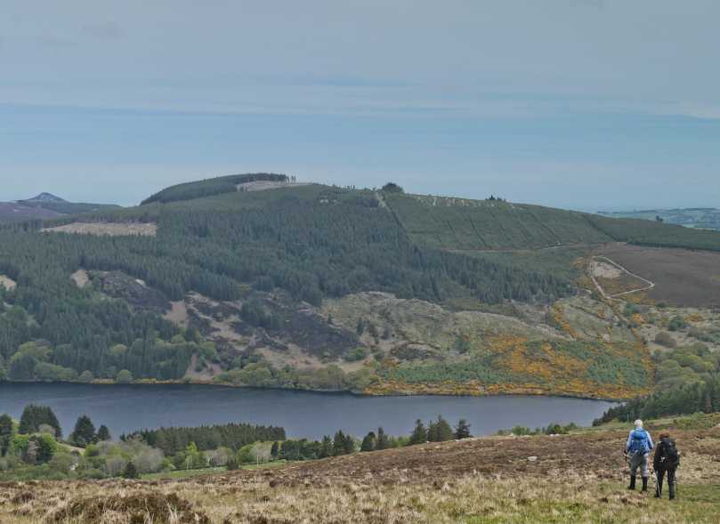
Picture: Ballinafunshoge from Scarr to the West.
One way to approach Ballinafunshoge is from the R759 which runs east from the Sally Gap to the Kilmacanoge - Roundwood road. The R759 passes above Lough Tay (the famous ‘Guinness Lake’ and is well worth a visit in its own right. The Wicklow Way cuts cross the R759 and enters a forest track at A (O173 063). Follow the Wicklow Way along the forest track for about 2 kms, walking very close to the summit of Sleamaine along the way. At approx B (O168 039) out for a forest ride running west through the trees. Follow this track for about 400 metres to the summit. Views are restricted here due to the trees, but there are nice views from the Wicklow Way track of the Roundwood Lakes. If coming from the R759 take the time to stop at the viewpoint at C (O169 071) for the amazing views over the Wicklow hills.
Approached from Sleamaine crossing over top of Cloghoge Valley Track ID (O16603 04672) but continuing on up grassy track keeping forest & fence to the left. The southern end of the East-West ride which crosses the summit exits the forest along this fence at IE (O16382 04320). There is a hole in the fence a few metres before the ride which is possible to crawl through. 5 minutes and the odd duck and crouch to avoid low branches and fallen trees will take you to the summit. A quick retrace of your steps will bring you back to the fence and out onto the open hillside. My next target was to be Cnoc Na Cloghoge on the other side of the valley but while descending the Cloghoge track which I had returned to, I noticed a track of sorts to my left running east in the direction of Kanturk. I decided to see where it might lead. While a diversion it may be off interest to some. There appears to be the ruins of a number of old stone houses/buildings (settlement?) at IF (O15838 04492). In the wonderful sunshine and with trees interspersed between them these ruins had a rustic beauty. Just beyond this the track runs into a green leafy glade before a switchback at IG (O15516 04360) and a short drop before joining the main Cloghoge Track just above a gate which is a private entrance to one of Lough Dan's sandy beaches. Before, taking the aforementioned switchback I carried on for about a hundred metres eastwards passing through a green gate while maintaining height to reach a vantage point above Lough Dan which affords great views of the lough, the beach, Kanturk and Scar. On joining the main Cloghoge track I was sorely tempted to ignore the Private signs on the gate so as to gain access to Cnoc Na Cloghoge within a few minutes. However, I resisted the temptation and made my way back to the Pier Gates, where I replenished my water supply before starting out again to scale Cnoc Na Cloghoge & Luggala. Linkback: mountainviews.ie/summit/516/comment/3809/
Read Less
Read More
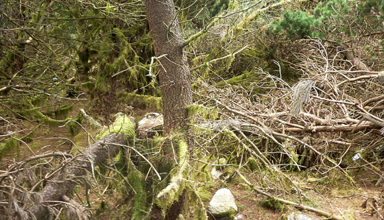
Picture: The top is somewhere around here!
Be warned, there is certainly no fun in this climb!
by Harry Goodman
1 Jun 2012
On 29 May 2012 I parked to the side of the forest road, also signed for the Wicklow Way, at H (O17327 06289) just S of the Pier Gates. Before climbing Ballinafunshoge I climbed Sleamaine en route. On coming back down from Sleamaine at I (O17402 05653) some 700m from the start point for the walk I turned right (S) and continued on the Wicklow Way for a further 2k in search of a forest ride to the right that would give me "easy" access to the top. This was at J (O16883 03919) where a clear but deeply rutted track should have led up NW for some 450m to the top, or so it seemed from the map (East-West Mapping Wicklow Mt West 1:30,000 ). This showed the high point on or just off the ride to the left side. As I made my way up the track was wide and clear of any obstacles to progress. Only a few minutes to the top and the end of a most enjoyable day in the Wicklow Mts. Then things began to go pear shaped. When I came to the first fallen or felled tree across the path I thought it would be a simple matter of walking around it to get back on course. Not so, obstruction followed obstruction requiring me to abandon the track and try and walk or crawl along side it through the trees. Going to say the least was difficult. Evenually I got back to the track at it's high point just before it started to descend. what appeared to be a clear way down. But was this the topG The GPS reading based on the mv Grid Ref indicated that I was still some 30/40 metres from the top and that it lay somewhere in the mire of tangled forestry. Against my better judgement I went in search of the "true" top and, after a difficult ten minutes or so foraging in and out the dense thicket of fallen/felled trees and shrubs, my reading had me within one or two metres of the mv Grid. Ref K (O16551 04203)! Job done, head for home!! Walking back along the Wicklow Way, reflecting on this particular experience I had to ask the question, was this climb of Ballinafunshoge what hillwalking is really all about ? Very definitely for me the answer must be a resounding NO!! While hillwalking for me is about challenge it is also about enjoyment, this latter aspect was clearly lacking in my walk up Ballinafunshoge. Linkback: mountainviews.ie/summit/516/comment/6840/
Read Less
Read More
Picture: The view west from the summit of Ballinafunshogue.
csd on Ballinafunshoge
by csd
15 Jul 2007
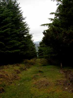
The summit of Ballinafunshogue is in the middle of a forest. Conveniently, a ride running East-West makes access from the Wicklow Way fairly straightforward. Just don't expect great views from the top! Linkback: mountainviews.ie/summit/516/comment/2772/
Read Less
Read More
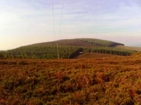
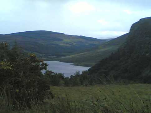
Picture: Ballinafunshoge in the distance with Lough Tay below
wicklore on Ballinafunshoge
by wicklore
3 Sep 2008
I had passed close to this summit twice previously while on the Wicklow Way but had never bothered going up. Taking advantage of my close proximity to the Dublin/Wicklow hills I went up after work.
csd gives clear directions for those who want a quick summit. I chose to blunder about the forest instead, which wasn't helped by the fact that I forgot my boots. With all this rain I was half swimming through the trees. What I liked about this hill is that I had a sense of peace and isolation. The summit is buried in the forest, and I doubt many make the trip to find it. Or maybe my sense of solitude was because I was the only hillwalker out at that hour in terrible weather!
My photo shows Ballinafunshoge in the background with Lough Tay below and the cliffs of Luggala to the right Linkback: mountainviews.ie/summit/516/comment/3279/
Read Less
Read More
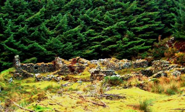
Scotch Village
by darrenf
22 Jan 2011
It was an overcast Sunday afternoon and I was looking for a short stroll which I had not completed previously. I recently remembered reading an article in Walking World Ireland describing a short loop around Ballinafunshoge and Sleamaine, so out came the Sept/Oct 2010 edition of the magazine and off I set to follow the route described by Denis Gill.
Plenty of parking is available at L (O174 063) and more parking is available at grey gates and other new parking areas along the R759 which overlook Lough Tay. The route decribed in WWI takes you within striking distance of both Sleamaine and Ballinafunshoge, while all the time offering up lovely views across the Vartry Reservoirs, Lough Dan and Lough Tay. There is also plenty of history on offer with the route passing by the ruins of a number of old settlement villages. The attached photo shows the ruins of Scotch Village, as named on the EastWest map (not named or shown on OS sheet 56).
A grand stroll for a lazy Sunday afternoon or long summer evening. Two and a half hours should complete the loop of 9km. Linkback: mountainviews.ie/summit/516/comment/6204/
Use of MountainViews is governed by conditions and a privacy policy.
Read general information about the site. Opinions in material here are not necessarily endorsed by MountainViews.
Hillwalking is a risk sport. Information in comments, walks, shared GPS tracks or about starting places may
not be accurate for example as regards safety or access permission. You are responsible for your safety and your permission to walk.
See the credits and list definitions.


 Our Facebook page.