Donation Request 2024

DONATE
Members and Supporters, the MountainViews Committee requests your help to meet the costs of the website and of other activities such as insured events or publications.
You do not have to be logged in to donate.
Features
Nearby features appear when you click the map.
Declutter tracks on map.
Place Search
Video
X
Pub: by
Bluestack Mountains Area , S: Belshade Subarea
Feature count in area: 45, all in Donegal, OSI/LPS Maps: 11, 6
Highest Place: Croaghgorm 674m

Starting Places (22) in area Bluestack Mountains:
An Leathchruach, Barnsmore Gap, Bensons Hill, Caldragh CP, Clogher South peak, Cruach Mhín an Neanta, Doobin, Eanybeg Water Bridge, Edergole Farm, Gaugin Mountain, Glennacree CP, Hillhead, Lough Finn West, Lough Magrath Beg NE, Lough Muck North, Meenaguse Lough, Sand Lough Forest Picnic Area, Scoil Náisúnta an Choimín, Sheskinlubanagh, Sruell Gap Farm, Sruell River Road, St Columbkilles Well and Altar

Summits & other features in area Bluestack Mountains:
Cen: Reelan Hills: Altnapaste 364m, Gaugin Mountain 565m, Lacroagh 403m, Boultypatrick 429m, Croveenananta 476m, Croaghubbrid 416m, Croaghugagh 410m
N: Fintown Hills: Aghla Mountain South Top 589m, Aghla Mountain 593m, Scraigs 426m, Croaghleheen 385m
NW: Glenties: Cloghercor South 301m, Derkbeg Hill 332m, Drumnalough Hill 282m
S: Belshade: Croaghgorm 674m, Croaghgorm South-West Top 597m, Croaghgorm East Top 594m, Ardnageer 642m, Ardnageer SW Top 626m, Banagher Hill 392m, Croaghbane 641m, Croaghgorm Far South-West Top 561m, Cronamuck 444m, Croaghbarnes 498.8m, Glascarns Hill 578.3m, Meenanea 435m
SE: Barnesmore: Brown's Hill 496.4m, Cloghervaddy 402m, Croaghagranagh 440m, Croaghanirwore 546.1m, Croaghbrack 401m, Croaghconnellagh 523m, Croaghnageer 569.1m, Croaghnageer East Top 543.5m, Croaghnageer North-East Top 521m, Croaghonagh 451m
SW: Eany Beg Hills: Binbane 453m, Binbane NE Top 439m, Lavagh Beg 650m, Lavagh More 671m, Binnasruell 505m, Carnaween 521m, Cloghmeen Hill 429m, Silver Hill 600m, Cullaghacro 476m

Note: this list of places may include island features such as summits, but not islands as such.
Rating graphic.
Croaghbarnes, 498.8m Hill Cruach an Bhearnais A name in Irish,
Place Rating ..
(Ir. Cruach an Bhearnais [SÓD*], 'stack of the gap'), Donegal County in Ulster province, in Carn Lists, Cruach an Bhearnais is the 575th highest place in Ireland.
Grid Reference G98986 90306, OS 1:50k mapsheet 11
Place visited by: 38 members, recently by: abeach, madfrankie, Colin Murphy, BleckCra, Carolyn105, eamonoc, srr45, AlanReid, melohara, noucamp, Lauranna, ColinCallanan, Aidy, Wilderness, simoburn
I visited this place: NO (You need to be a logged-in member for this.)
Longitude: -8.016521, Latitude: 54.760681, Easting: 198987, Northing: 390307, Prominence: 54m,  Isolation: 1.4km
ITM: 598936 890297
Bedrock type: Main granite (adamellite), (Barnesmore Granite, G2 variety)

  Short or GPS IDs, 6 char: Crghbr, 10 char: Crghbrns

Linkback: https://mountainviews.ie/summit/462/
Gallery for Croaghbarnes (Cruach an Bhearnais) and surrounds
Summary for Croaghbarnes (Cruach an Bhearnais): Remote, challenging Carn.
Summary created by Colin Murphy 2023-05-08 15:26:16
            MountainViews.ie picture about Croaghbarnes (<em>Cruach an Bhearnais</em>)
Picture: As seen from Cronamuck - Croaghbarnes is the rocky prominence dead centre of photo.
Croaghbarnes is a fairly remote summit that requires a 11-12km round trip to do in isolation. On approach is from point Edergole (G97259 87055), next to some disapidated farm buildings, where there is parking for a couple of cars. Follow the meandering track to the NE where it will eventually come alongside a stream and some ancient machinery, which may have been involved in flood control. After that the track deteriorates to a muddy trail, but continues to a point where the stream forks at A (G98487 88831). Follow the fork to the left, crossing the stream where you can (crossing points are not plentiful) and when near Lough Belshade ascend the steepish slope to the NE. Alternately, at the point where the river forks, continue up the valley to the NE for a further 2 km and ascend via a slightly less steep grassy slope to B (G99532 90173), then turn SW for 500m back along the rocky ridge.
Linkback: mountainviews.ie/summit/462/comment/5221/
Member Comments for Croaghbarnes (Cruach an Bhearnais)

            MountainViews.ie picture about Croaghbarnes (<em>Cruach an Bhearnais</em>)
Picture: Sinner posing as Saint on Croaghbarnes
eflanaga on Croaghbarnes
by eflanaga 12 Nov 2007
From Croaghaniwore (see for previous leg) I turned towards Croaghbarnes dropping down fairly steeply through mixture of rocky hillside and long tussock grass eventually flattening out onto the saddle dividing the Corabber (SW) & Cronamuck (NE) River valleys, before climbing up onto Croaghbarnes. Here I found a suitable camping site about 150m short of the top. I set camp and retired early determined to get an early start the following morning. From the camp site the following morning, I popped up onto the summit IC (G99061 90362). From here the summits of many of the peaks around and about were visible while beneath them the countryside was enveloped in an early morning (07.00hrs) mist. As I made my way to my next target, Croaghbane, I came across one of those rarely seen phenomena a ''brocken spectre' with my silhouette caught directly in it - very 'saintly' - I think not!. Linkback: mountainviews.ie/summit/462/comment/2893/
Read Less
Read More

            MountainViews.ie picture about Croaghbarnes (<em>Cruach an Bhearnais</em>)
Picture: A Forbidding Looking Croaghbane From Croaghbarnes
A Wild Landscape
by Aidy 13 Apr 2015
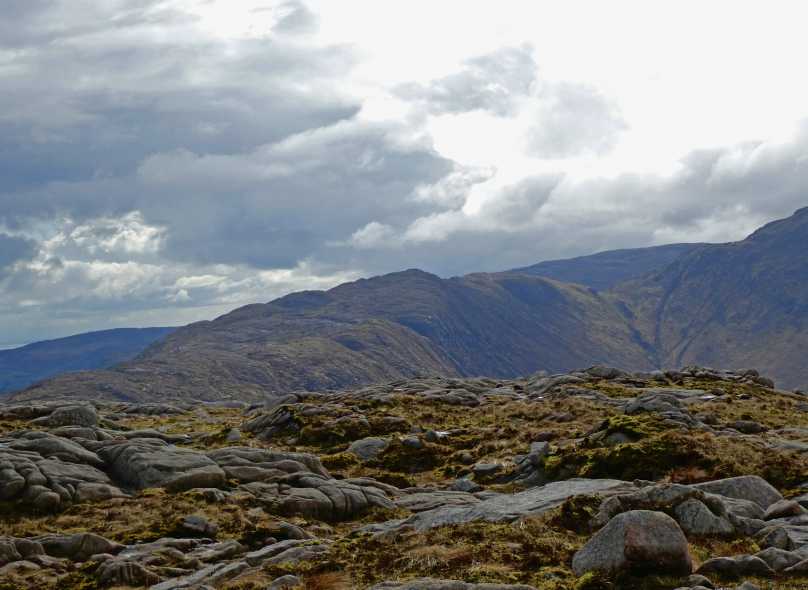
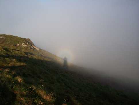
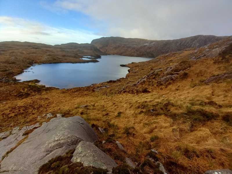
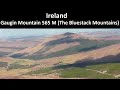
Recently I've been trying to get to all the summits in the central Bluestacks, which are usually difficult to reach, being far from roads, and behind other mountains. On Sunday, I targeted Croaghbarnes, Meenanea and Cronamuck. I started from an unnamed road, north of Lough Eske, overlooking the Corabber River. A few yards after leaving the car I arrived at a gate with Private Property, No Tresspassing, and for good measure, Beware of the Bull signs, so there are definitely access issues here. I confess, I pushed on regardless, taking the gravel track uphill, still overlooking the river, until it petered out on higher ground to the north. Luckily, I wasn't spotted, or the landowner wasn't bothered. As I suspected, there was also no trace of a bull in this terrain. Once off the track, I entered a confusing area of micro hills and valleys, with high, steep slopes to my left, but I was able to follow the river to Lough Belshade. It was a dramatic sight, backed by the steep cliffs of the main Bluestack ridge, still dusted with snow. This is a really wild, beautiful area. I went up the steep, rocky southwest side of Croaghbarnes, emerging on to the lough covered summit area, and continuing from there to the top. Views from there were breathtaking for 360 degrees, and the hard walking was well rewarded. A magnificent walk which I continued on to Meenanea and Cronamuck. Linkback: mountainviews.ie/summit/462/comment/17927/
Read Less
Read More

            MountainViews.ie picture about Croaghbarnes (<em>Cruach an Bhearnais</em>)
Picture: Lough Belshade, from lower slopes croaghbarnes
Central Bluestack Carn
by eamonoc 2 Feb 2023
Climbed as first of three Carns in the heart of the Bluestack Mts, approach from minor road at Northern end of
Lough Eske Linkback: mountainviews.ie/summit/462/comment/23825/
Read Less
Read More
EDIT Point of Interest
text
Videos


Recent Contributions
x
Conditions and Info
Use of MountainViews is governed by conditions and a privacy policy.
Read general information about the site.
Opinions in material here are not necessarily endorsed by MountainViews.
Hillwalking is a risk sport. Information in comments, walks, shared GPS tracks or about starting places may not be accurate for example as regards safety or access permission. You are responsible for your safety and your permission to walk.
See the credits and list definitions.

OSi logo
OSNI/LPS logo
Open Street Map
(Various variations used.)
British summit data courtesy:
Database of British & Irish Hills