Members and Supporters, the MountainViews Committee requests your help to meet the costs of the website and of other activities such as insured events or publications.
Feature count in area: 45, all in Donegal,
OSI/LPS Maps: 11, 6
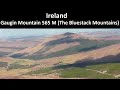
Highest Place: Croaghgorm 674m
Starting Places (22) in area Bluestack Mountains: An Leathchruach, Barnsmore Gap, Bensons Hill, Caldragh CP, Clogher South peak, Cruach Mhín an Neanta, Doobin, Eanybeg Water Bridge, Edergole Farm, Gaugin Mountain, Glennacree CP, Hillhead, Lough Finn West, Lough Magrath Beg NE, Lough Muck North, Meenaguse Lough, Sand Lough Forest Picnic Area, Scoil Náisúnta an Choimín, Sheskinlubanagh, Sruell Gap Farm, Sruell River Road, St Columbkilles Well and Altar
Summits & other features in area Bluestack Mountains: Cen: Reelan Hills: Altnapaste 364m, Gaugin Mountain 565m, Lacroagh 403m, Boultypatrick 429m, Croveenananta 476m, Croaghubbrid 416m, Croaghugagh 410m N: Fintown Hills: Aghla Mountain South Top 589m, Aghla Mountain 593m, Scraigs 426m, Croaghleheen 385m NW: Glenties: Cloghercor South 301m, Derkbeg Hill 332m, Drumnalough Hill 282m S: Belshade: Croaghgorm 674m, Croaghgorm South-West Top 597m, Croaghgorm East Top 594m, Ardnageer 642m, Ardnageer SW Top 626m, Banagher Hill 392m, Croaghbane 641m, Croaghgorm Far South-West Top 561m, Cronamuck 444m, Croaghbarnes 498.8m, Glascarns Hill 578.3m, Meenanea 435m SE: Barnesmore: Brown's Hill 496.4m, Cloghervaddy 402m, Croaghagranagh 440m, Croaghanirwore 546.1m, Croaghbrack 401m, Croaghconnellagh 523m, Croaghnageer 569.1m, Croaghnageer East Top 543.5m, Croaghnageer North-East Top 521m, Croaghonagh 451m SW: Eany Beg Hills: Binbane 453m, Binbane NE Top 439m, Lavagh Beg 650m, Lavagh More 671m, Binnasruell 505m, Carnaween 521m, Cloghmeen Hill 429m, Silver Hill 600m, Cullaghacro 476m
Note: this list of places may include island features such as summits, but not
islands as such.
Croaghanirwore, 546.1mMountain Cruach an Fhir Mhóir A name in Irish,
Place Rating ..
(Ir. Cruach an Fhir Mhóir [SOD], 'stack of the big man'), Donegal County in Ulster province, in Arderin Lists, Croaghanirwore is the 431st highest place in Ireland.
Grid Reference H00238 89214,
OS 1:50k mapsheet 11 Place visited by: 56members, recently by: gdg, Krzysztof_K, dino, srr45, annem, AlanReid, eamonoc, osullivanm, simon3, wicklore, BogRunner1, ilenia, Ulsterpooka, Grumbler, Lauranna
I visited this place: NO (You need to be a logged-in member for this.)
Longitude: -7.997084, Latitude: 54.750874, Easting: 200238, Northing: 389215,
Prominence: 93m, Isolation: 1.1km ITM: 600187 889206 Bedrock type: Main granite (adamellite), (Barnesmore Granite, G2 variety) Notes on name: An Fear Mór, 'the big man', occurs in a number of Irish place-names. It may refer to a giant or be a euphemism for the Devil. Cf. Crockanirmore, Crockanirvore and Oweyanirvore, all in Termmonmaguirk parish, Co. Tyrone; also Cuan an Fhir Mhóir, Greatman's Bay in Connemara, where the name is associated with the legend of a giant who fished for whales.
Short or GPS IDs, 6 char: Crg546, 10 char: Crghnrwr Linkback: https://mountainviews.ie/summit/363/
Gallery for Croaghanirwore (Cruach an Fhir Mhóir) and surrounds
Summary
for Croaghanirwore (Cruach an Fhir Mhóir):
Well worth the effort..
Summary created by Harry Goodman
2015-03-31 15:03:18
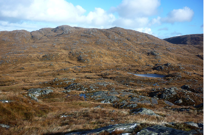
Picture: View across to Croaghanirwore from Croaghagranagh.
On the E side of L. Eske A (G984 843) go NE steeply uphill. Where the tarred road ends, there is ample off road parking. Follow the farm track to L. Fad and around it's left side. When it peters out go down left (NW) to cross the Barnes River B (H003 868). Continue up N through trackless long tussocky grass and hummocky ground.to C (H00088 87826). At this point in the walk it is possible to take an out and back detour of 1.6km Croaghagranagh by crossing the river/stream, and going out and up WNW. Otherwise, continue up N past Illanmore Lough and then up a rugged slope to Pt. 534 D (H004 889). The summit cairn lies NNW, across a shallow dip. Out and back is 8km with an additional 1.6km if the option of visiting Croaghagranagh is taken.There is a fine view point W to the main Bluestack's ridge above Lough Belshade. A route up can also be taken from the car park at the N end of L. Eske. Walk NE along the road to E (G969 861) and take a rough, narrow road N to Edergole. When the road/track ends continue up NE along side the Corabber River to cross it where it flows down from the left. Still going NE make for the head of the valley F (G997 898) , a broad and boggy area, before turning right to go steeply uphill to the summit. The route out and back is about 13km. This top along with six others can also be crossed in a strenuous linear walk from Barnes Gap to the R253 W of Commeen. 18 km and 1,600m of ascent.
(see Knockgorm for first part of walk).Croaghanirwore (isn't that a fantastic name)is separated from the central Bluestack ridge by a deep river valley - it is a lenghty hill aligned NE to SW, being wet and boggy until near the top when rock shows through, number of minor summits. From summit of Croaghbane take bearing on col with Croaghbarnes and descend some 600 ft SE. Fantastic views left into bleak Owendoo River valley snaking along backed by steep slopes of Croaghbarnes. To the right are completing a circuit of Lough Belshade which can be seen if move to other side of the ridge. Ahead get good view of the little loughs on the summit of Croaghbarnes which is only one metre shy of inclusion on this excellent website. From the col it is a short climb to the top of Croaghbarnes,passing the loughs to the summit at 499 m. Drop down SE to river valley which is rather wet with long grass ( head of Corraber River valley which used earlier to reach L Belshade). There is now a climb of some 250m to the summit of Croaghanirwore over wet grassy ground. Reach a false summit and cross a gulley before a short climb to the small summit cairn. There are extensive views in all directions but especially back into the heart of the Bluestacks around L Belshade (see pic). To the N past Gaugin the Derryveagh Mountains are laid out and to the W Slieve League with the Sligo Mountains over Donegal Bay. Drop down SE into the next river valley to the col with Croaghnageer (see for next part of walk). Linkback: mountainviews.ie/summit/363/comment/1240/
Read Less
Read More
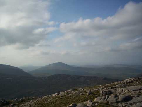
Picture: Looking towards Gaugin Mt from Croaghaniwore summit
Trip report part 2
by eflanaga
8 Aug 2012
Climbed June 7th – From top of Croaghnageer (see for first part of walk) I took a bearing of 309 degrees NW dropping down the fairly short distance on to upper part of river valley between them. Here the terrain was much firmer and after crossing the river (stream) I made my way towards the obvious swathe of green running down from a breach in the ridge of Croaghaniwore. About twenty metres up this ‘track’ I veered left and scaled the eastern side of the mountain in a zig-zag fashion (I was beginning to feel the weight of my pack).Normally, the climb to the top should not pose any great difficulty. Once again the views from the top are excellent, enhanced as they were on this occasion by the beautiful evening sunshine. The wind turbines over in the direction of Barnesmore reflected brightly in the sunshine, and like its near neighbour provided stunning vies into the main Bluestacks across the valley. Indeed, all around the countryside was looking at its best. From here I turned towards Croaghbarnes dropping down fairly steeply through mixture of rocky and long tussock grass eventually flattening out onto the saddle dividing the Corabber (SW) & Cronamuck (NE) River valleys, before climbing up onto Croaghbarnes. Here I found a suitable camping site about 150m short of the top. I set camp and retired early determined to get an early start the following morning. Linkback: mountainviews.ie/summit/363/comment/2384/
Read Less
Read More
madfrankie on Croaghanirwore
by madfrankie
19 Aug 2003
Man, was this a tough one. The Blue Stacks tend towards rugged, but our approach from the south-west (from the track which leads most people to Lough Belshade) cannot be recommended. Endless false summits and a convoluted landscape that I did not discern on the map. And the midges didn't help. Probably better done as a longer walk from Barnesmore Gap. Linkback: mountainviews.ie/summit/363/comment/609/
Read Less
Read More
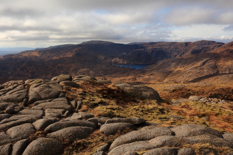
Picture: Lough Belshade and Croaghgorm, near summit.
Hard Won But Well Worth It
by Aidy
27 Mar 2015
I have made a few attempts to get to Croaghanirwore, but have always been beaten back by bad weather on the occasions I've tried. I've always used the same route, starting at Barnes Gap on the N15, going up Browns Hill, and on to Croaghnageer. Croaghnageer was always as far as I'd got until this successful attempt when I started in gloomy conditions, but ended up in beautiful weather, although very cold. It felt exhilarating to be finally standing on the summit, at least partly because of its inaccessability. It is a long walk over difficult terrain, with no tracks or trails on the little walked summits which have to be crossed to get here. There are also some steep climbs on the way, particularly up Browns Hill and the northwest slopes of Croaghnageer. The reward is a real feeling of wilderness deep in the Bluestacks, with stunning views around the rest of the range, virtually all traces of civilisation hidden by the surrounding peaks. A manificent walk on this route - one of the best I've had, made all the better by being hard won. Linkback: mountainviews.ie/summit/363/comment/17893/
Read Less
Read More
Bluestacks Circuit
by three5four0
11 May 2010
After the careful descent from Croaghnageer, ascend one of the grassy rakes, spotted on your descent, and then over more rocky ground to the summit. Which is a spot height in a kidney shaped contour ring, with a re-entrant descending from it, which provides a sheltered place for your lunch. Linkback: mountainviews.ie/summit/363/comment/4713/
Use of MountainViews is governed by conditions and a privacy policy.
Read general information about the site. Opinions in material here are not necessarily endorsed by MountainViews.
Hillwalking is a risk sport. Information in comments, walks, shared GPS tracks or about starting places may
not be accurate for example as regards safety or access permission. You are responsible for your safety and your permission to walk.
See the credits and list definitions.


 Our Facebook page.