Members and Supporters, the MountainViews Committee requests your help to meet the costs of the website and of other activities such as insured events or publications.
Feature count in area: 115, by county: Wicklow: 108, Kildare: 4, Wexford: 2, Carlow: 3, of which 1 is in both Wexford and Wicklow, of which 1 is in both Carlow and Wicklow,
OSI/LPS Maps: 28B, 55, 56, 61, 62, AWW, EW-DM, EW-LG, EW-WE, EW-WS
Highest Place: Lugnaquilla 924.7m
Starting Places (205) in area Wicklow: 1916 Memorial Car Park, Aghavannagh Ow Bridge, Aghowle Wood, Altidore Wood Entrance, Annacurra National School, Annalecka Bridge, Asbawn Brook L8350, Aughrim National School, Ballard Road, Ballinabarny Gap, Ballinagappoge Bridge Layby, Ballinagappoge Mountain Hairpin, Ballinagore, Ballinahinch Wood, Ballinastoe MBT CP, Ballinastraw South, Ballineddan Upr Fork, Ballinfoyle Upr Cross, Ballycoog, Ballycreen Brook Bridge, Ballycumber, Ballycumber Bridge, Ballycumber Lane, Ballycumber Wicklow Way, Ballylerane, Ballylow Bridge, Ballylusk Quarry, Ballymanus Lane, Ballymoyle Shooting Lodge, Ballynultagh Gap, Ballynultagh Lane, Ballyreagh Wood, Ballyross Forest, Ballysmuttan Long Stone, Baravore, Barnbawn South, Barranisky North, Barranisky West, Bohilla Land Roundabout, Bohilla Lane Mid, Boranaraltry Bridge, Bray Harbour, Brewel West, Brittas Bay North CP, Buckroney Sand Dunes CP, Bus Terminus, Camera Hill Track Cross, Castletimon Wood North, Clara Vale, Clone House Road, Clonegal, Cloon Wood Cp, Coate Bridge, Coolballintaggart Ledge, Coolbawn House Lane, Cransillagh Brook , Crone Wood CP, Crossbridge, Crossoona Rath, Cummer Wood South, Curtlestown Wood CP, Deputy's Pass CP, Derralossary Church, Derry River Bridge, Devil's Glen CP, Devil's Glen Wood, Djouce Wood Calary, Djouce Wood Lake, Djouce Wood Long Hill, Donard, Donnelly's Lane Car Sales, Drumgoff Forest, Dunranhill North, Dunranhill SE, Dunranhill South, Dwyer McAllister Cottage CP, Enniskerry, Fentons Pub, Fitzsimons Park GAA, unuseableFlemings Footbridge Glen Rd, Gap Pub, Gap Road, Glen Beach CP, Glen of the Downs CP, Glenbride Lane, Glenbride Lodge, Glencree Reconciliation, Glendalough, Glenealy GAA, Glenmacnass Tonelagee CP, Glenmalure Hostel, Glenmalure Lodge, Glenmalure Waterfall, Glenview Hotel, Gowle House, Great Sugar Loaf CP, Grove Bar, Heffernans Well Wood, Hill View, Hollywood Glen, JB Malone CP, Johnnie Fox Pub, Keadeen NE trail, Keadeen Trailhead, Kevins Way Footbridge, Kilbride Army Camp Entrance, Kilcandra South, Kilcommon View, Killalongford Wood, Kilmacrea Cross Roads, Kilranelagh House Gate, Kilruddery Car Park, Kilruddery Cottages, Kings River, Kippure Bridge, Kippure Estate, Kippure Transmitter Gate, Knickeen Cross, Knocknaboley Lane Leeraghs Bog, Knocknaboley Lane Stone Cottage, Knockrath Little, Knockree west, Kyle Loop North, Lackan Wood S, Lake Dr Fraughan Brook, Lake Drive, Lake Park Cross, Lake View Pub, Laragh Free Car Park, Laragh NSch, Lead Mines CP, Liffey Bridge, Liffey Head Bridge, Lough Bray Lower, Lough Bray Upper, Lough Tay North Viewing Point, Lough Tay Wicklow Way CP, Luglass Lane L97561, Lugnagun Track, Macreddin Village, Mangans Lane, Military Road Carrigshouk Hill, Military Road Inchavore River Nth, Military Road Inchavore River Sth, Military Road NW Lough Tay, Military Road Ballyboy Bridge, Military Road Cloghoge Brook, Military Road Croaghanmoira, Military Road Fananierin, Military Road LaraghWicklow Way, Military Road Slieve Maan, Monspolien Bridge, Moortown House, Mountain Rescue HQ, Muskeagh Little Wood, Nahanagan Lough NE, Novara Avenue, Bray, Oiltiagh Brook Knickeen, Old Bridge Cross, Old Bridge Scouts , Old Wicklow Way entrance, Paddock Hill SE, Pier Gates CP, Powerscourt Waterfall CP, Putland Road, Quintagh East, Raheen Park CP, Raheenleagh East, Railway Walk CP, Rathdrum Railway Station, Rednagh Wood, Rocky Valley, Roundwood, Sally Gap, Sally Gap N, Seefin Trailhead, Seskin SE, Shankill Tributary Bridge, Shay Elliott, Sheepshanks Bridge, Shillelagh, Slievecorragh Track, Slievefoore South, Sraghoe Brook, St John's Church, St Kevins Chair, St Kevins Church, St Kevins Way R756, Stone Circle Bridge, Stookeen South, Stranahely Wood, Stranakelly Cross Roads, Tallyho, Templeboden, Tithewer, Tomcoyle L, Tomriland Wood, Toor Brook, Trooperstown Hill Access, Turlough Hill CP, Upper Lake CP, Vallymount GAA CP, Vartry Reservoir Upper, Zellers Pub
Summits & other features in area Wicklow: Cen: Glendalough North: Brockagh Mountain 556.9m, Brockagh Mountain NW Top 549.5m, Brockagh Mountain SE Top 471.7m, Camaderry East Top 677.3m, Camaderry Mountain 698.6m, Conavalla 734m, Tomaneena 682.4m Cen: Glendalough South: Carriglineen Mountain 456.6m, Cullentragh Mountain 510m, Derrybawn Mountain 476.1m, Kirikee Mountain 474.5m, Lugduff 653.2m, Lugduff SE Top 638m, Mullacor 660.7m, Trooperstown Hill 430m N Cen: Tonelagee: Carrignagunneen 561m, Fair Mountain 571.2m, Stoney Top 713.7m, Tonelagee 815.8m, Tonelagee E Top 668m, Tonelagee South-East Top 545.8m NE: Bray & Kilmacanogue: Bray Head Hill 238.9m, Carrigoona Commons East 242m, Downs Hill 372.9m, Great Sugar Loaf 501.2m, Little Sugar Loaf 342.4m NE: Djouce: Djouce 725.5m, Knockree 342.1m, Maulin 570m, Tonduff 642m, Tonduff East Top 593m, War Hill 684.8m, White Hill 631.1m NE: Fancy: Ballinafunshoge 480m, Kanturk 527.4m, Knocknacloghoge 532.4m, Luggala 593.3m, Robber's Pass Hill 508.9m, Scarr 640m, Scarr North-West Top 559.8m, Sleamaine 430m NE: Vartry: Ballinacorbeg 336m, Ballycurry 301m, Dunranhill 342m, Mount Kennedy 365.9m NW: Blessington: Carrigleitrim 408m, Lugnagun 446.2m, Slieveroe 332m, Sorrel Hill 599.5m NW: Mullaghcleevaun: Black Hill 602.2m, Carrigshouk 572.5m, Carrigvore 682.4m, Duff Hill 720.8m, Gravale 719m, Moanbane 703m, Mullaghcleevaun 846.7m, Mullaghcleevaun East Top 796m, Silsean 698m S: Aughrim Hills: Cushbawn 400m, Killeagh 249m, Moneyteige North 427m, Preban Hill 389m S: Croaghanmoira: Ballinacor Mountain 529.3m, Ballycurragh Hill 536m, Ballyteige 447m, Carrickashane Mountain 508m, Croaghanmoira 662.3m, Croaghanmoira North Top 579.5m, Fananierin 426m, Slieve Maan 547.8m, Slieve Maan North Top 546.1m S: Croghan Kinsella: Annagh Hill 454m, Croghan Kinsella 606m, Croghan Kinsella East Top 562.1m, Slievefoore 414m S: Shillelagh Hills: Lakeen 357m, Monaughrim 206m, Seskin 344m, Stookeen 420m S: Tinahely Hills: Ballycumber Hill 429.7m, Eagle Hill 296m, Muskeagh Hill 398.2m SE: Wicklow South East: Ballinastraw 284m, Ballyguile Hill 188m, Barranisky 280m, Carrick Mountain 381m, Collon Hill 238m, Kilnamanagh Hill 217m, Westaston Hill 270m W: Baltinglass: Ballyhook Hill 288m, Baltinglass Hill 382m, Carrig Mountain 571m, Carrigeen Hill 298m, Cloghnagaune 385m, Corballis Hill 258m, Keadeen Mountain 653m, Spinans Hill 409m, Spinans Hill SE Top 400m, Tinoran Hill 312m W: Cen Lugnaquilla: Ballineddan Mountain 652.3m, Benleagh 689m, Camenabologue 758m, Camenabologue SE Top 663m, Cloghernagh 800m, Corrigasleggaun 794.6m, Lugnaquilla 924.7m, Slievemaan 759.7m W: Donard: Brewel Hill 222m, Church Mountain 544m, Corriebracks 531m, Lobawn 636m, Slievecorragh 418m, Sugarloaf 552m, Table Mountain 701.7m, Table Mountain West Top 563m
Note: this list of places may include island features such as summits, but not
islands as such.
Brockagh Mountain, 556.9mMountain Sliabh na Brocaí A name in Irish,
Place Rating ..
(poss. Ir. ‡Sliabh na Brocaí [PDT], ‘mountain of Brocach or place of badgers’), Wicklow County in Leinster province, in Arderin Lists, Brockagh Mountain is the 401st highest place in Ireland.
Grid Reference T10856 99053,
OS 1:50k mapsheet 56 Place visited by: 554members, recently by: Padraigin, MartMc, davidrenshaw, maoris, Magic, Carolineswalsh, konrad, SeanPurcell, MickM45, muddypaws, Kaszmirek78, abacusms, bandre, JohnHoare, Ainegavgav
I visited this place: NO (You need to be a logged-in member for this.)
Longitude: -6.348382, Latitude: 53.030977, Easting: 310857, Northing: 199053,
Prominence: 33m, Isolation: 0.8km ITM: 710781 699087 Bedrock type: Adamellite with microcline phenocrysts, (Glendalough Adamellite) Notes on name: Brockagh is a townland in the parish of Derrylossary. Price derives this name from Brocach, 'place frequented by badgers' [PNCW].
Short or GPS IDs, 6 char: BrckMn, 10 char: BrckghMntn Linkback: https://mountainviews.ie/summit/346/
Gallery for Brockagh Mountain (Sliabh na Brocaí) and surrounds
Summary
for Brockagh Mountain (Sliabh na Brocaí):
Poor relation amongst peers
Summary created by CaptainVertigo, march-fixer
2014-04-13 10:21:56
Situated as an elbow in the south eastern spur of Tonelagee, it is an excellent point on the route down from Tonelagee to Laragh. There are wonderful views out north-east to Scarr, south-east to Brockagh SE Top and west to Camaderry. Glendalough is hidden away by the Camaderry ridge but there are wonderful views north-east to Wicklow Gap and Lough Nahanagan.
Seldom summited directly (but if that is your wish please consider parking at the entrance to the disused mine at K'WyFB (T09781 98518)), it is more often reached as part of a walk down from Tonelagee or up from Brockagh SE Top, its smaller sibling. It can be incorporated as part of several linear or circuit walks in the area.
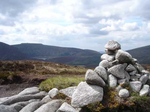
There is a nice little cairn at the summit A (T10858 99057) with good shelter for a couple of persons. While the track up from Brockagh SE Top is well defined, the track up to Tonelagee is not. There is a track nearby to the north B (T111 992) which will lead you down to a forest track and back to Laragh. See the summary details for Brockagh SE Top for information on parking and track start.
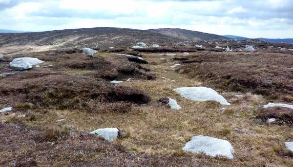
Picture: Brockagh summit view towards Turlough Hill
csd on Brockagh Mountain
by csd
26 Feb 2006
Perhaps a more interesting access to the summit of Brockagh can be attained from the eastern corner. You can park
at the forest entrance beside St Kevin's parish church in Laragh (at grid Lara (T140 968)) and follow the track east before it swings NW (shown on the Healy map). It's then possible to use the forest tracks to gain height up to Grid C (T130 979) before
tackling the slog up to the ridge and then WNW up to Brockagh itself. Picture shows the view from the summit over to
Turlough Hill. Linkback: mountainviews.ie/summit/346/comment/1722/
Read Less
Read More
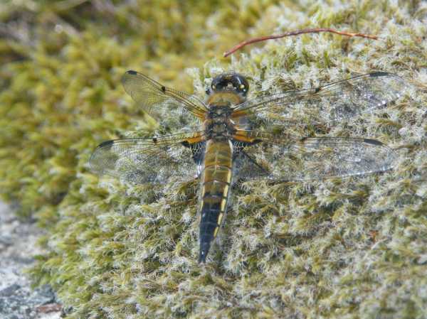
Picture: Four-Spotted Chaser on Brockagh Mtn
Never alone!
by paddyhillsbagger
6 Jun 2012
Sitting on Brockagh summit in brilliant sunshine, eating my sandwiches and contemplating life as my wife pounded the streets of Dublin with 40,000 other women in the mini marathon. I began to realise I wasn't alone. Fluttering around the summit cairn were a few brilliantly coloured Red Admiral butterflies! I duly got out the camera to snap them. In doing so I noticed other flyers around the boggy pools close-by and managed a picture of this little fellow! I'm led to believe it's a Four-Spotted Chaser and fairly common. It goes to show you are never alone on a top! Linkback: mountainviews.ie/summit/346/comment/6848/
Read Less
Read More
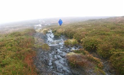
Picture: Brockagh's muddy approach
Colin Murphy on Brockagh Mountain
by Colin Murphy
17 Nov 2008
The track between Brockagh SE and Brockagh (and beyond towards Tonelagee) is now all but unusable due to a combination of high usage and the fact that it never stopped raining all summer. It's now necessary to tramp through the heather on either side for most of the way, considerably slowing progress towards the top. Linkback: mountainviews.ie/summit/346/comment/3448/
Read Less
Read More
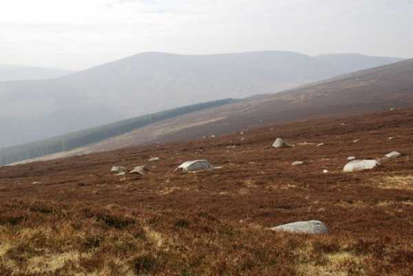
Picture: Camaderry and Turlogh Hill from path between Brockagh and Brockagh Sth East
Brockagh
by eamonoc
10 Mar 2011
On 3/3/2011 climbed Brockagh from Wicklow Gap road at point D (T095 993). About 2 mins from road passed old mine slag heaps and headed up behind these towards a prominent boulder on the horizon took 10mins to boulder. From this boulder took a approx 15mins to the top of Brockagh, the heather was not a difficulty as a lot of it had been burnt and this made for relatively easy going.
Following rising ground, eventually reached summit after about 25mins from road. Views in all directions were excellent, continued on to Brockagh Sth East Top due to recent dry spell this well trodden track was suprisingly dry and pleasant to walk on. Retraced outward route to car. Total time taken was 1hr 50mins. Linkback: mountainviews.ie/summit/346/comment/6267/
Read Less
Read More
Picture: Brockagh Mt. top right. from the ridge down from Tonelagee.
Central top on a fine ridge walk.
by Harry Goodman
15 May 2010
I climbed Brockagh Mountain on 10 May 2010 as part of a round which also included Tonelagee NE Top and Brockagh Mountain SE Top. ( For the first part of the route see my comments on Tonelagee NE Top.)
From Tonelagee NE Top I headed S down the slope to cross a stream at E (O09389 01060) before climbing up the short slope to meet the ridge coming down from Tonelagee. Once there I soon picked up a path and headed SE over Pt 546 F (O10000 00400), then up to and over the lower top of Brockagh Mt. ( Pt. 548) before walking some 700m across the flat ridge to the summit cairn. Unfortunately due to an extended and heavy shower my visability at the top was very poor. The way from Brockagh Mountain to its SE namesake follows a clear track south east ! (For further information on the final top in my looped walk see my comments on Brockagh SE Top) Linkback: mountainviews.ie/summit/346/comment/4733/
Use of MountainViews is governed by conditions and a privacy policy.
Read general information about the site. Opinions in material here are not necessarily endorsed by MountainViews.
Hillwalking is a risk sport. Information in comments, walks, shared GPS tracks or about starting places may
not be accurate for example as regards safety or access permission. You are responsible for your safety and your permission to walk.
See the credits and list definitions.


 Our Facebook page.