Members and Supporters, the MountainViews Committee requests your help to meet the costs of the website and of other activities such as insured events or publications.
Feature count in area: 38, all in Donegal,
OSI/LPS Maps: 1, 11, 2, 6
Highest Place: Errigal 751m
Starting Places (29) in area Derryveagh Mountains: Aleahan Lough, Altderry Bridge, An Chúirt Hotel, Astelleen Burn Waterfall, Derryreel Lough, Dunlewy Lough E, Dunlewy Lough Viewing Point, Errigal Hostel, Errigal Parking, Glenveagh Bridge, Glenveagh National Park SW, Glenveigh Castle, Keel Lough N, Losset North, Lough Acrobane Farmhouse, Lough Ascardan, Lough Barra Slipway CP, Lough Barra W, Meenagoppoge Burn Bridge, Mín Uí Bhaoil, Muckish Gap Shrine, Muckish North Access Road, Nabrackbaddy Lough, Procklis Lough, River Barra Bridge NE, River Barra Bridge SW, Sand Lough NE, Sruhancrolee Bridge, Stranamarragh Bridge
Summits & other features in area Derryveagh Mountains: Cen: Dooish: Dooish 651.5m, Dooish SW Top 528m, Dooish SE Top 553.9m, Saggartnadooish 506.4m, Saggartnadooish East Top 478.9m Cen: Errigal: Errigal 751m, Mackoght 555m Cen: Glenveagh Upper: Crockfadda 485m, Crockfadda East Top 454m, Crockballaghgeeha 480m, Crockmulroney 430m, Staghall Mountain 486m, Croaghnasaggart 480m, Maumlack 480m Cen: Lough Keel (Meencorwick): Crockglass 489m, Addernymore 416m, Grogan More 457m, Crocknafarragh 517m, Crocknafarragh SE Top 470m Cen: Slieve Snaght: Crockfadda 529m, Crockfadda NE Top 502m, Crocknasharragh 495m, Drumnalifferny Far NE Top 535m, Bingorms 578m, Drumnalifferny Mountain 596m, Drumnalifferny Mountain NE Top 585m, Slieve Snaght 678m N: Aghla: Aghla Beg 563.9m, Aghla Beg South Top 602.3m, Aghla More 581.2m, Ardloughnabrackbaddy 472.5m, Crocknalaragagh 470.6m N: Muckish: Muckish 667.1m, Croaghaderry 222m, Crockawama 238m, Derryreel 232m S: Doochary: Croaghleconnell 266m S: Dungloe: Crovehy 315m
Note: this list of places may include island features such as summits, but not
islands as such.
Aghla More, 581.2mMountain An Eachla Mhór A name in Irish,
Place Rating ..
(Ir. An Eachla Mhór [DUPN], poss. 'great look-out point/prospect'), Donegal County in Ulster province, in Arderin, Irish Best Hundred Lists, An Eachla Mhór is the 334th highest place in Ireland.
Grid Reference B94976 23928,
OS 1:50k mapsheet 1 Place visited by: 208members, recently by: Sweeney, Carolineswalsh, ronanmckee, FoxyxxxLoxy, JohnHoare, Krzysztof_K, miriam, farmerjoe, Arcticaurora, Cecil1976, abeach, Leonas_Escapades, johncusack, a3642278, derekfanning
I visited this place: NO (You need to be a logged-in member for this.)
Longitude: -8.079404, Latitude: 55.062662, Easting: 194977, Northing: 423928,
Prominence: 156.2m, Isolation: 0.8km ITM: 594927 923911 Bedrock type: Whitish quarztite with pebble beds, (Ards Quartzite Formation) Notes on name: P.W. Joyce, interprets this name as Ir. eachla or eachlann, 'stable', suggesting it is an example of a mountain named after a feature situated at its foot. However, Patrick McKay prefers to see the modern form as a re-interpretation of the original name Achla, a form of Aichill, meaning 'a look-out point or prospect' (Dictionary of Ulster Place-Names). Achill Island in Mayo (Ir. Acaill) may well be derived from the same root.
Short or GPS IDs, 6 char: AghlMr, 10 char: Aghla More Linkback: https://mountainviews.ie/summit/306/
Gallery for Aghla More (An Eachla Mhór) and surrounds
Summary
for Aghla More (An Eachla Mhór):
A majestic viewing platform for the Donegal Highlands.
Summary created by Harry Goodman
2011-12-02 14:02:55
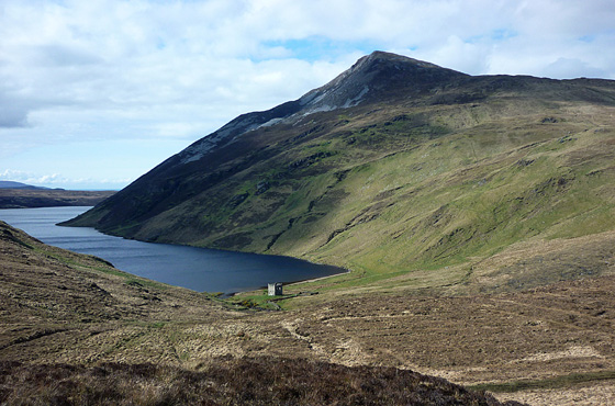
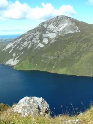
Picture: View from the south of Altan Lough, Altan Tower and Agla More.
Direct ascents of this mountain can be made from either the S or N. Route 1 (South). Park off road at A (B953 205) on the R251. Follow a rough track NNW up the hillside for 1k across the E shoulder of Beaghy before dropping down NE by a winding track for 2k to Altan Tower at the SE end of Altan Lough B (B954 226). Go NNE around and above the Lough Shore to C (B955 231) before going steeply N up the hillside, with the forest edge to the right, to gain a high saddle at D (B953 238). Turn up left NW for the final short climb to the summit cairn. Route 2 (North). Park near the N end of Altan Lough at Procklis E (B936 254) and go E to cross the Tullaghbegly River by large stepping stones F (B938 253). (If the river is unsafe to cross due to high water levels go back N along the road to where it crosses beneath the road at G (B938 262) and then follow back keeping the river to the right.) Once across the river head ESE up the hillside to H (B948 248) before swinging S (right) up the N spur of the mountain for an increasingly steep climb up to the summit, a further 1k along. Agla More commands a majestic viewpoint for the Donegal Highlands. East are the two tops of Agla Beg and Agla Beg South with Muckish Mt. beyond. To the W is the fine cone of Errigal and S is the impressive line of tops from Dooish to Slieve Snaght.
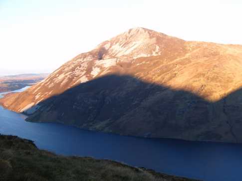
From the S shore of Atlan Lough cross the river and pass the abandoned tower to head for the height of Agla More, rising some 1,300 ft from the depths of the Lough. The going is good on ground mown by sheep and are initially accompanied by the roar of falling water from the nearby river. As climb there are good views down over the Lough and across to the steep ground of Beaghy, with an impressive Dooish bathed in late evening sunshine across the valley containing the R251and its intrusive sound of traffic. Pick up a fence separating the forestry plantation and follow uphill. There are some patched of scree before reaching the summit and its small cairn. From the top there are great views straight down to Atlan Lough and in the fast fading light on a clear day I could clearly make out the immediate Derryveaghs, the Bluestacks, Inishowen and the offshore islands (with a lighthouse casting its gaze over the cold waters of the Atlantic at regular intervals). I went on to climb the two remaining Aghlas, not getting the benefit of the fantastic views in the dark but lying against the large cairn on Aghla Beg staring up at the clouds of stars was a great finish to a great day and in stark contrast to the brilliant sunshine atop Errigal earlier in the day. Linkback: mountainviews.ie/summit/306/comment/2073/
Read Less
Read More
eoin on Aghla More
by eoin
30 Mar 2004
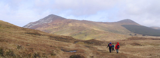
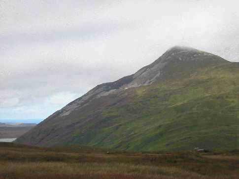
1st of the triple summits of the Aghlas, this peak is quite a slog to reach from whatever approach you use. You feel all of the 380-400 metres of ascent up the grassy slopes. Completed the Aghla trio last weekend on a windy but dry and sunny spring day. Started from the main road that leads into Altan Castle (see photo with the summits of Aghla Mor and Aghla Beg (South) clearly visible). This path is easy to follow but mucky and wet!! From the castle/lodge on the shores of Lough Altan you head up a feint path on the right then veer left to follow a bounday fence the whole way up to the saddleback ridge of the Aghlas. Our route involved a quick ascent of Aghla Mor (with incredible views of Errigal and the coast), then return to the saddle (optional route to the west of the lake) and contour around to summit at the large rocky cairn on Aghla Beg. From there you follow the brief dip and rise to the domed summit of Aghla Beg (South) or Ardloughnabrockbaddy and then return along the saddleback ridge to the path down to the lake.
It took us about 4 1/4 hours walking at a steady pace plus a few snack stops to bring it nearer 5 hours. This is not a beginners walk and is a fair old hike up and down and back again, but the views from all three summits and almost every point in between are just excellent with the whole of Donegal spread before you (on a clear day!!) Linkback: mountainviews.ie/summit/306/comment/897/
Read Less
Read More
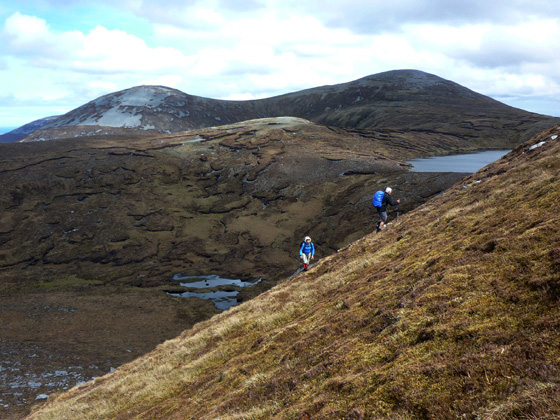
Picture: Climbing the steep NW spur with Ardloughnabrackbaddy and the Agla Begs beyond
A steep but very worthwhile climb
by Harry Goodman
29 Nov 2011
On 1 May 2010 I climbed Agla More as part of a walk from Muckish Gap to Altan Lough which also included Crocknalaragagh, the two tops of Agla Beg and Ardloughnabrackbaddy (Pt. 473). Although I had been to the top of Agla More previously, on a number of E - W crossings of the range, I had never diviated from the usual route around the S of Lough Feenane before climbing up to the summit. On this occasion, as we were including mv listed Ardloughnabrackbaddy (Pt. 473), we decided rather than backtrack E around the Lough to continue down SW across the outflow from L. Feenane I (B953 243). We then went W across a large patch of rock debris before continuing up to meet the grassy NW spur of Agla More J (B947 243). Once there it was a steep climb up SE to the summit cairn. From the top we dropped down SE to a high saddle D (B953 238) above L Feenane before heading SSE steeply downhill, with the forrest on our left, to C (B955 231) and then SW down to Altan Lough B (B954 226). Once past the ruined Altan Tower, we crossed the river and followed a winding track uphill over the SE shoulder of Beaghy and then out to the R251. For anyone doing an E - W traverse of these hills I would commend the diversion over Pt. 473 (described above) as worthwhile, both to include a mv listed top that might not otherwise be visited and as a change from the "traditional" route to Agla More. Once there, if the conditions are right, the views from Agla More will live long in the memory. Linkback: mountainviews.ie/summit/306/comment/6638/
Use of MountainViews is governed by conditions and a privacy policy.
Read general information about the site. Opinions in material here are not necessarily endorsed by MountainViews.
Hillwalking is a risk sport. Information in comments, walks, shared GPS tracks or about starting places may
not be accurate for example as regards safety or access permission. You are responsible for your safety and your permission to walk.
See the credits and list definitions.


 Our Facebook page.