Donation Request 2024

DONATE
Members and Supporters, the MountainViews Committee requests your help to meet the costs of the website and of other activities such as insured events or publications.
You do not have to be logged in to donate.
Features
Nearby features appear when you click the map.
Declutter tracks on map.
Place Search
Video
X
Pub: by
Mourne Mountains Area , E: Donard Subarea
Feature count in area: 58, all in Down, OSI/LPS Maps: 20, 29, EW-CLY
Highest Place: Slieve Donard 849m

Starting Places (33) in area Mourne Mountains:
Alex Steddom Tree, Aughrim Airstrip, Ben Crom Dam, Bloody Bridge Car Park, Carlingford Greenway, Carrick Little, Crocknafeola Wood, Crotlieve Mountain, Donard Car Park Newcastle, Drummanmore Picnic, Fofanny Reservoir, Forest Office CP, Gamekeepers Lodge CP, Happy Valley Trassey Rd, Hen Mountain CP, Leitrim Lodge CP, Mayo Road Corner, Meelmore Lodge, Newcastle Harbour, Ott CP, Red Bog Road, Rourkes Park, Sandy Brae, Silent Valley Reservoir Head Rd, Slieve Donard Trail Head, Slieve Foye Viewing Point, Slievefoy Forest CP, Spelga Dam E, Spelga Dam N, Spelga Dam S, Trassey Car Park, Two Mile River CP, Yellow Water Park

Summits & other features in area Mourne Mountains:
Cen: Loughshannagh: Ben Crom 526m, Carn Mountain 585.2m, Carn Mountain North Top 553.7m, Doan 592.6m, Ott Mountain 526.8m, Slieve Loughshannagh 617m, Slieve Muck 670.4m, Slievenaglogh 445m
E: Binnian: Slieve Binnian 745.9m, Slieve Binnian East Top 639m, Slieve Binnian North Top 678m, Slieve Binnian North Tor 682.5m, Wee Binnian 460m
E: Donard: Chimney Rock Mountain 656m, Crossone 540m, Millstone Mountain 460m, Rocky Mountain 524m, Slieve Donard 849m
E: Lamagan: Cove Mountain 654.8m, Slieve Beg 595.9m, Slievelamagan 702.2m
N: Bearnagh: Slieve Bearnagh 739m, Slieve Bearnagh North Tor 680m, Slieve Meelbeg 701.9m, Slieve Meelmore 687m
N: Castlewellan: Slievenalargy 280m, Slievenaslat 272m
N: Commedagh: Slieve Commedagh 767m, Slieve Corragh 641.9m, Slievenaglogh 584.4m, Slievenaglogh East Top 571m
N: Croob: Cratlieve 429m, Slieve Croob 534m, Slievegarran 391m, Slievenisky 446m
N: Rathfriland: Knockiveagh 235m
S: Kilkeel: Knockchree 306m
S: Rostrevor: Crenville 460m, Finlieve 578m, Slievemartin 485m, Slievemeel 420m, Slievemeen 472m
W: Hilltown: Gruggandoo 382m, Slieveacarnane 296m
W: Slievemoughanmore: Crotlieve Mountain 347m, Eagle Mountain 638m, Rocky Mountain 404m, Shanlieve 626m, Slievemoughanmore 560m, Tievedockaragh 473m, Wee Slievemoughan 428m
W: Spelga: Butter Mountain 500m, Cock Mountain 504m, Cock Mountain South-West Top 505m, Hen Mountain 354m, Pigeon Rock Mountain 534m, Pigeon Rock Mountain South Top 530m, Slievenamiskan 444m

Note: this list of places may include island features such as summits, but not islands as such.
Rating graphic.
Chimney Rock Mountain, 656m Mountain Sliabh an Aoire A name in Irish,
Place Rating ..
(Ir. Sliabh an Aoire (?) [PNNI], 'mountain of the shepherd'), Down County in Ulster province, in Arderin, Vandeleur-Lynam, Irish Highest Hundred Lists, Chimney Rock Mountain is the 185th highest place in Ireland.
Grid Reference J36408 25721, OS 1:50k mapsheet 29
Place visited by: 404 members, recently by: Daingean, rhw, Henning86, MeabhTiernan, orlaithfitz, davidrenshaw, Magic, Prem, Carolineswalsh, BrianKennan, ToughSoles, muddypaws, Lyner, Dee68, Nailer1967
I visited this place: NO (You need to be a logged-in member for this.)
Longitude: -5.912485, Latitude: 54.162373, Easting: 336408, Northing: 325721, Prominence: 131m,  Isolation: 1.4km
ITM: 736323 825723
Bedrock type: Granite granophyre, (Mourne Mountains granite)
Notes on name: Granite was quarried on the northern slopes of this mountain. Mourne granite is typically grey and of high quality. Vast quantities used to be exported for construction. The streets and docks of Liverpool were built of Mourne granite.
  Short or GPS IDs, 6 char: ChmnRc, 10 char: ChmnyRckMn

Linkback: https://mountainviews.ie/summit/178/
Gallery for Chimney Rock Mountain (Sliabh an Aoire) and surrounds
Summary for Chimney Rock Mountain (Sliabh an Aoire): Fine views from this rocky seaside peak in the Eastern Mournes
Summary created by markmjcampion, Trailtrekker, wicklore 2023-06-18 11:45:33
            MountainViews.ie picture about Chimney Rock Mountain (<em>Sliabh an Aoire</em>)
Picture: Chimney Rock from Rocky Mountain
Chimney Rock Mountain sits proudly above the Irish Sea in the E Mournes. It’s a flat-top adorned by impressive tors and has three distinctive spurs emanating from its summit area. Amazing views over the Mournes esp. Donard and across the Annalong Valley to Slieve Beg, Cove, Lamagan and S. Binnian; also seaward to the Isle of Man.

Evidence of extensive mining exists along the side of the mountain at places like Carr’s Face, and the route up from the Bloody Bridge follows a mining track for a lot of its length. Five American airmen died when their B26 Marauder crashed here during training in 1944. Wreckage remains on the hill, as well as a memorial plaque and cross at A (J362 255).

NE. Park at Blood Br (J38882 27114) and follow the Bloody Bridge track for about 4 kms up to the Mourne Wall and turn SE to climb 1.5kms to the summit. 1.5hrs

Alternatively it can be climbed more directly from the Bloody Bridge track by striking out south from the track at B (J37688 26913) to tackle the steep northern slopes. Aim first for the summit of Slievenagarragh before heading west for the summit of CRM. Note that on this route there are plenty of rocks and mining-related scree to contend with in places on the northern slopes. 1hr+

S. Park at junction RurkPk (J35780 22320) and take the track N which starts 80m to the E. At C (J35284 23513) swing right up to the SSE spur of Rocky Mt. and on to D (J35326 26480) before turning SE to climb 1.5kms to the summit. 2.5hrs

Notable tracks incl. track/4003 and track/4796.
Linkback: mountainviews.ie/summit/178/comment/4938/
Member Comments for Chimney Rock Mountain (Sliabh an Aoire)
Comment create / edit display placeholder

            MountainViews.ie picture about Chimney Rock Mountain (<em>Sliabh an Aoire</em>)
Bleck Cra on Chimney Rock Mountain
by Bleck Cra 16 Feb 2009
There is something about Spence’s river valley not quite right: unsettling, unnerving. Something bigger than a sad story of a lost pilot ploughing into its East Stand – something age-old; a patient audience perhaps of this and a thousand other sad events.
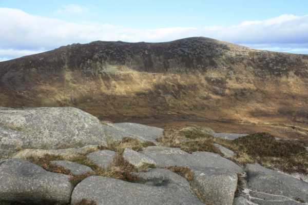
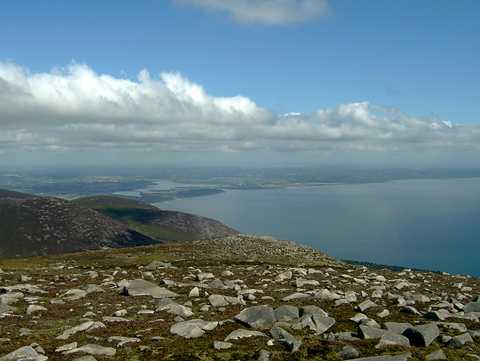
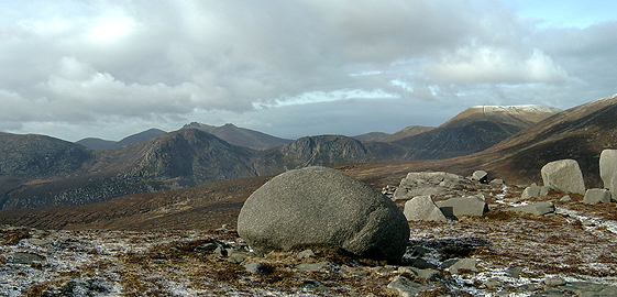
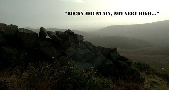
The weight of melancholy in the place is overpowering – or is it just that dark days simply draw a lone spectator on to its drear stage? I fell under the spell of Chimney Rock Mountain the very first time I saw her. Pretty, little, odd: an outrider on the fringes of the pack proper. The alpha girls, Donard, Commedagh, Meel More, wide Lamagan and diva Bearnagh collude and conspire but Chimneyrock stands alone, silent, unassuming. From Chimney Rock Mountain you see everything we have been and everything we are. On a warm, new Sunday in February, a panorama panning North/South picked out Scotland, the Isle of Man, snow on English tops, a pool of canary yellow sunshine that spilled out from Drogheda dawn ‘til dusk and on its glazed horizon, heartbreaking Howth and memories of dolphins and rainbows. On her South Western edge, leaden feet draw you down into the spinning nothingness of Spence’s Valley. There are no tracks or clues and as you descend into this huge, heathery bowl, the emptiness seems to engulf you. A damp clamber up on to Rocky Mountain and return along the wall or Buttress holds the spectre of Spence’s Valley to heel and Donard Bog (currently Donard Bog Archipelago) soon occupies your attention – and a yomp home to Bloody Bridge (Start/Finish). It was in Spence’s, a blazing Spring, some years back. Invisible water gurgled under hidden holly, holy, hollow trees. Suddenly in my mind, the taste of fuel and French perfume, which might explain why he flew, uncontrollably, into Chimney Rock Mountain. Linkback: mountainviews.ie/summit/178/comment/3595/
Read Less
Read More

janerobbie on Chimney Rock Mountain
by janerobbie 26 Jan 2005
Ah, Bleck Cra, like many a man you’ve been taken in by a good looking girl. Look behind that pretty little face and you’ll find a cold hearted woman with a dark and dangerous past. During WW2 an American B-26 decided to take a closer look at this little stunner. She clipped his wings and sent him hurtling in smithereens down her curvaceous sides. If you want to see the result of this woman’s wrath, cross the stile between Rocky and Chimney Rock, turn left towards the Bloody Bridge River and at the first small quarry turn right to cross Spence’s River and head for the summit. Keep the quarry at your back and from the river to the summit, and especially once you cross the quarry track, you’ll find the debris – an engine, lots of leads and aluminum (no, not a spelling mistake – this is an American plane) and other things I didn’t recognise because I’ve never worked in an aircraft factory. There used to be a plaque, on the rock beside the engine, but it’s gone now – a victim of thieves, just like the Northern Bank. Linkback: mountainviews.ie/summit/178/comment/1441/
Read Less
Read More

            MountainViews.ie picture about Chimney Rock Mountain (<em>Sliabh an Aoire</em>)
Bleck Cra on Chimney Rock Mountain
by Bleck Cra 21 Feb 2005
There are worse things than Christmas cardigans. Christmas raybands. And they’ve started to emerge: small, grey boil-washed men with wraprounds that could melt radar.
“Coul enough”, said one. “Dark enough too,” I imagined as he blundered blindly on. The north wind doth blow and we shall have snow and our monkeys shall all be brass. A relentless howl, abetted by mischievous flurries of soft hail, nudged a rake of raggle taggle tough nuts into a merciless Mournes. Like a child fighting sleep, we are fighting Spring and it’s birth seems oddly painful. Spences Valley, by the Glen River, the Saddle and Donard Bog is strange, desolate and melancholy. On a chill February morning the one shoe and rag doll remains of desperate lives stand weary-stone and forsaken, deep in the hill. Deserted quarries, ragged tracks and the bleached bones of once-bold farm buildings. Today, Spence’s River did not try to drown me. The Mournes are sensationally grippy. Into G1 grantite and A1 Vibram, you can hang by your soles on a near vertical incline: this goes also for the burns and bogs - except for Spence’s and the Annalong. These serpents attract some invisible algae, so a day of lepping crag to crag can end, head down in one of these torrents, with a dislocated hip and a pissed-off face. Chimney Rock Mountain is the most beautiful place on earth. On a bad day, you can see your whole life: the high peaks ahead, the tantalising drop below, the round comfort of the here and now and the line of Dalriada that shapes all Lallan and Ullan Scots: its politics uncomfortable and its geology inescapable. Ayrshire, Galloway, Antrim, Down and the Isle of Man. View the whole heap from Chimney Rock Mountain and be transformed. Access also from Bloody Bridge. Linkback: mountainviews.ie/summit/178/comment/1489/
Read Less
Read More

            MountainViews.ie picture about Chimney Rock Mountain (<em>Sliabh an Aoire</em>)
Picture: the perfect spot?
gerrym on Chimney Rock Mountain
by gerrym 23 Nov 2007
Climbed 29.3.04 parking at Bloody Bridge (E (J388 269)) and following path along Bloody Bridge River. This makes a welcome change to following the Glen River if you haven't tried it before. A diversion was provided by a group of young people, presumably from the nearby outdoor pursuits centre, taking the plunge into one of the rock pools in the river. When the quarry track becomes visible on the opposite bank (F (J377 268)) cross the river and follow it. Turn off left and climb the slopes of Slievenagarragh (450m) on firm ground. An hour after starting reached summmit cairn with nice views out to sea. Chimney Rock looms ahead to the west and a further half hour reaches the summit ridge. Aim for the rocky tors to the north where can spend a little time exploring with great views across to Binnian and Lamagan and to Donard. Head for the summit cairn to the south east crossing a couple of little rocky mini summits on the way. There is a delightful stone shelter just below the summit cairn. Will need to backtrack north again and will have to decide on which of the many possible options to take to continue - I dropped down to the Mourne Wall and followed it south to climb Rocky Mountain. Returned along the Bloody Bridge Path to the carpark.

Thought this would be a perfect camping spot this year. Heading up from Donard Park by the Glen River on a summer evening. Met a few people coming down off the hills but we were the only ones heading up this late. Clear blue skies bathed Newcastle in sunshine whilst the Glen River valley hid in the shadow of its imposing guardians. The climb up to the wall is followed by a tramp along the Brandy Pad and up to the rocky tors on the summit of Chimney Rock. We set up camp in the shadow of one of the tors, providing some shelter and offering a magnificent view down over the Irish Sea. As darkness descended the lighthouse at St. Johns Points swept a narrow beam of concentrated light out over the water, lights from houses on the Isle of Man were only a stones throw away. We cooked some hot food and settled in to a great nights sleep, on top of the world in our eyes. Next morning it was a case of packing and heading back down, again in good weather. A fantastic experinence of camping high in the Mournes with no other visible souls, looking down from the darkness to civilisation and brightness far below. An easy ans accessible camping option with fantastic views and far from the madding crowds. Linkback: mountainviews.ie/summit/178/comment/900/
Read Less
Read More

            MountainViews.ie picture about Chimney Rock Mountain (<em>Sliabh an Aoire</em>)
Bleck Cra on Chimney Rock Mountain
by Bleck Cra 26 Oct 2004
Mountains are like women: wild, dramatic; thin and bitter or wide and warm - but all beautiful. (Yes yes … thin and bitter too…). “Pretty” is best - and the prettiest girl in the class is Chimney Rock Mountain: little, curvaceous, undemanding with some delightful nooks and crannies. Sunday I trailed up the entirely Bloody Bridge track. Cloud low; wind aggressive. Hold seawards of the wall to caress Chimney Rock’s ankle. Weave through raised bog into sandy tracks and a stroll to 3 small tops - the last, bearing the strangely melancholy construction that gives her her name. A glimpse of glen and of sea. Magical.
Drop down and up Rocky Mountain. And here he comes. A drip on his nose, face the colour of chewing gum, his hat skewiff and a 1:50 pinned to his chest. “You OK?”. “What?.” “Where you heading ?” “Chimney Rock,” he pointed, in the opposite direction. “Over there”. “No it isn’t”. He dug a shiny compass from the blackness of his sac and walked round it like a dog eyeing a frog “Very magnetic, these hills” he confided. I could feel a drip coming to my own nose. As the mist thickened, it cleared for him - that he was completely Alain Prost. “I came up the Annalong” - yeeees, in a banana boat. “to do some compass work”- yeeees, I’m waiting. “by Carr’s Face” - noooo, because you’re an idiot not a contortionist. Then I hit on it. “I was going to do the Mournes, Mont Blanc and back again but sure I think I’ll just go home.” He took the bait: “Ach, me too.” “You’ll be taking the wall, down there?“ I pronounced flawlesly, pointing like John Travolta, “to the road.” Exactly my plan,” he grinned, backing into his weightless world. Linkback: mountainviews.ie/summit/178/comment/1278/
Read Less
Read More
EDIT Point of Interest
text
Videos


Recent Contributions
x
Conditions and Info
Use of MountainViews is governed by conditions and a privacy policy.
Read general information about the site.
Opinions in material here are not necessarily endorsed by MountainViews.
Hillwalking is a risk sport. Information in comments, walks, shared GPS tracks or about starting places may not be accurate for example as regards safety or access permission. You are responsible for your safety and your permission to walk.
See the credits and list definitions.

OSi logo
OSNI/LPS logo
Open Street Map
(Various variations used.)
British summit data courtesy:
Database of British & Irish Hills