Donation Request 2024
You do not have to be logged in to donate.
DONATE
Members and Supporters, the MountainViews Committee requests your help to meet the costs of the website and of other activities such as insured events or publications.You do not have to be logged in to donate.
Welcome to MountainViews
If you want to use the website often please enrol (quick and free) at top right.
If you want to use the website often please enrol (quick and free) at top right.
Overview

For more map options click on any overview map area or any detail map feature.
Detail Map Features
Showing 18 items:
Beann 752m, Knocknagantee 674.3m, Finnararagh 667m, Coomura Mountain 666m, Beann SW Top 657m, Beann Far SW Top 636.2m, Coomnacronia 636m, Sallagh 570m, Sallagh South-West Top 543m,
3622, 18km
713, 14km
2833, 14km
4725, 12km
4727, 12km
4933, 10km
4723, 10km
3507, 10km
4966, 7km
Beann 752m, Knocknagantee 674.3m, Finnararagh 667m, Coomura Mountain 666m, Beann SW Top 657m, Beann Far SW Top 636.2m, Coomnacronia 636m, Sallagh 570m, Sallagh South-West Top 543m,
Tracks:
Find Suggested Walks
Find hill, mountain, island, coastal feature.
Videos


Recent Contributions
 Get Notifications
Get Notifications
Carran NE Top: Approach via wind farm tracks
 Collaborative entry
Circumnavigation of Tawny Rower
 glencree
Long Island: No sign of the Great Gatsby
 Fergalh
Near Church Mountain, Wicklow (Ireland)
Knockree: Reasonably clear path to summit
 hibby
hibby
Keeloges-Aganny loop
 Colin Murphy
Little Sugar Loaf: Windy at the top
 hibby
hibby
Aganny Top: Approach from SW
 Colin Murphy
Great option for a day hike over Slieve Carr (inspired by Irish Peaks)
Keeloges: Go and enjoy.
 Collaborative entry
Bynack More, A'Choinneach and Bynack Beg
 billbaggins
Slieve Carr: Great option for a day hike over Slieve Carr (inspired by Irish Pea
 nupat
nupat
Conditions and Info
Use of MountainViews is governed by conditions and a privacy policy.
Read general information about the site.
Opinions in material here are not necessarily endorsed by MountainViews.
Hillwalking is a risk sport. Information in comments, walks, shared GPS tracks or about starting places may not be accurate for example as regards safety or access permission. You are responsible for your safety and your permission to walk.
See the credits and list definitions.
 Visit our Facebook page.
Video display
Dunkerron Mountains
Area Cen: Knocknagantee Subarea
Place count in area: 65,
OSI/LPS Maps: 78, 83, 84, 85, EW-KNP, EW-R
Highest place: Stumpa Dúloigh, 784m
Maximum height for area: 784 metres,
Maximum prominence for area: 528 metres,
Places in area Dunkerron Mountains:
Knocknagantee Near West Top 628m
Cen: An Bheann Mhór:An Bheann Mhór 674.7mAn Bhinn Láir 514mCoomcallee 648.9mBeann na Stiocairí 673.1mCoomnahorna 590mGlanbeg 485.8mSlievenashaska 578mSlievenashaska South Top 565.4m
Cen: Knocknagantee:Knockmoyle 682.1mFinnararagh 667mCnoc Breasail 591mKnocknagantee 674.3mKnocknagantee West Top 553mCoomnacronia 636mCoomura Mountain 666m
Cen: Mullaghanattin:An Cnoc Riabhach 534mBeann 752mBeann Far SW Top 636.2mBeann NE Top 692mBeann South Top 639mBeann SW Top 657mSallagh 570mMullaghanattin 773mMullaghanattin East Top 594mSallagh South-West Top 543m
E: Kenmare:Gortamullin 205mKnockanaskill 356mLetter South 362m
N: Knocknacusha:Knocknacusha 547m
NE: Knocknabreeda Ridge:Crossderry 489mKnocknabreeda 569mMothaillín 506m
NE: Knocknagapple:Bascadh 595mBascadh West Top 569mBoughil 631mCnoc na gCapall 639mKnocklomena 641m
NE: Stumpa Dúloigh:Broaghnabinnia 745mKnockaunanattin 569mKnockaunanattin West Top 466.1mStumpa Dúloigh 784mStumpa Dúloigh SE Top 780mStumpa Dúloigh SW Top 663m
SW: Caherdaniel:Farraniaragh Mountain 468mEagle Hill 155mReenearagh 162mBeenarourke 304mKnocknasullig 117mCahernageeha Mountain 498.7m
SW: Coad ( Castle Cove ):Beenrour 418mEagles Hill 549mMullaghbeg 509m
SW: Coomduff:Coomduff 244m
SW: Deenish:Deenish Island (2) 144m
SW: Esknaloughoge:Esknaloughoge 416mEsknaloughoge North Top 420m
SW: Scarriff:Scarriff Island 252m
SW: Sneem:An Bheann Mhór 309.3mDereenavurrig Hill 261mKnockanamadane 270mKnocknafreaghane 316.5mKnocknagullion 413m
SW: Staigue:Staigue Top 459mStaigue NE Top 435m
Note: this list of places includes island features such as summits, but not islands as such.
Highest place:
Stumpa Dúloigh, 784mPlaces in area Dunkerron Mountains:
Knocknagantee Near West Top 628mCen: An Bheann Mhór:
An Bheann Mhór 674.7mAn Bhinn Láir 514mCoomcallee 648.9mBeann na Stiocairí 673.1mCoomnahorna 590mGlanbeg 485.8mSlievenashaska 578mSlievenashaska South Top 565.4mCen: Knocknagantee:
Knockmoyle 682.1mFinnararagh 667mCnoc Breasail 591mKnocknagantee 674.3mKnocknagantee West Top 553mCoomnacronia 636mCoomura Mountain 666mCen: Mullaghanattin:
An Cnoc Riabhach 534mBeann 752mBeann Far SW Top 636.2mBeann NE Top 692mBeann South Top 639mBeann SW Top 657mSallagh 570mMullaghanattin 773mMullaghanattin East Top 594mSallagh South-West Top 543mE: Kenmare:
Gortamullin 205mKnockanaskill 356mLetter South 362mN: Knocknacusha:
Knocknacusha 547mNE: Knocknabreeda Ridge:
Crossderry 489mKnocknabreeda 569mMothaillín 506mNE: Knocknagapple:
Bascadh 595mBascadh West Top 569mBoughil 631mCnoc na gCapall 639mKnocklomena 641mNE: Stumpa Dúloigh:
Broaghnabinnia 745mKnockaunanattin 569mKnockaunanattin West Top 466.1mStumpa Dúloigh 784mStumpa Dúloigh SE Top 780mStumpa Dúloigh SW Top 663mSW: Caherdaniel:
Farraniaragh Mountain 468mEagle Hill 155mReenearagh 162mBeenarourke 304mKnocknasullig 117mCahernageeha Mountain 498.7mSW: Coad ( Castle Cove ):
Beenrour 418mEagles Hill 549mMullaghbeg 509mSW: Coomduff:
Coomduff 244mSW: Deenish:
Deenish Island (2) 144mSW: Esknaloughoge:
Esknaloughoge 416mEsknaloughoge North Top 420mSW: Scarriff:
Scarriff Island 252mSW: Sneem:
An Bheann Mhór 309.3mDereenavurrig Hill 261mKnockanamadane 270mKnocknafreaghane 316.5mKnocknagullion 413mSW: Staigue:
Staigue Top 459mStaigue NE Top 435mNote: this list of places includes island features such as summits, but not islands as such.

Bedrock type: Green sandstone & siltstone, (St. Finans Sandstone Formation)
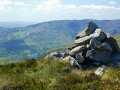
Finnararagh is a corruption of Finnavogagh, the name of an area of rough pasture on the plateau W of this peak. The name is correctly recorded in the Ordnance Survey Name Book, but was misspelt when transferred to the map. The peak itself is locally called An Corrán, which aptly describes its crescent-shaped cliffs that dominate Lough Coomeen. An Corrán is the 165th highest place in Ireland.
Linkback: https://mountainviews.ie/summit/160/
COMMENTS for Finnararagh (An Corrán) 1 2 Next page >>  Follow this place's comments

|
|
|
|
||
| MountainViews.ie, a Hill-walking Website for the island of Ireland. 2400 Summiteers, 1480 Contributors, maintainer of lists: Arderins, Vandeleur-Lynams, Highest Hundred, County Highpoints etc | |||