Donation Request 2024

DONATE
Members and Supporters, the MountainViews Committee requests your help to meet the costs of the website and of other activities such as insured events or publications.
You do not have to be logged in to donate.
Features
Nearby features appear when you click the map.
Declutter tracks on map.
Place Search
Video
X
Pub: by
Wicklow Area , Cen: Glendalough North Subarea
Feature count in area: 115, by county: Wicklow: 108, Kildare: 4, Wexford: 2, Carlow: 3, of which 1 is in both Wexford and Wicklow, of which 1 is in both Carlow and Wicklow, OSI/LPS Maps: 28B, 55, 56, 61, 62, AWW, EW-DM, EW-LG, EW-WE, EW-WS
Highest Place: Lugnaquilla 924.7m

Starting Places (205) in area Wicklow:
1916 Memorial Car Park, Aghavannagh Ow Bridge, Aghowle Wood, Altidore Wood Entrance, Annacurra National School, Annalecka Bridge, Asbawn Brook L8350, Aughrim National School, Ballard Road, Ballinabarny Gap, Ballinagappoge Bridge Layby, Ballinagappoge Mountain Hairpin, Ballinagore, Ballinahinch Wood, Ballinastoe MBT CP, Ballinastraw South, Ballineddan Upr Fork, Ballinfoyle Upr Cross, Ballycoog, Ballycreen Brook Bridge, Ballycumber, Ballycumber Bridge, Ballycumber Lane, Ballycumber Wicklow Way, Ballylerane, Ballylow Bridge, Ballylusk Quarry, Ballymanus Lane, Ballymoyle Shooting Lodge, Ballynultagh Gap, Ballynultagh Lane, Ballyreagh Wood, Ballyross Forest, Ballysmuttan Long Stone, Baravore, Barnbawn South, Barranisky North, Barranisky West, Bohilla Land Roundabout, Bohilla Lane Mid, Boranaraltry Bridge, Bray Harbour, Brewel West, Brittas Bay North CP, Buckroney Sand Dunes CP, Bus Terminus, Camera Hill Track Cross, Castletimon Wood North, Clara Vale, Clone House Road, Clonegal, Cloon Wood Cp, Coate Bridge, Coolballintaggart Ledge, Coolbawn House Lane, Cransillagh Brook , Crone Wood CP, Crossbridge, Crossoona Rath, Cummer Wood South, Curtlestown Wood CP, Deputy's Pass CP, Derralossary Church, Derry River Bridge, Devil's Glen CP, Devil's Glen Wood, Djouce Wood Calary, Djouce Wood Lake, Djouce Wood Long Hill, Donard, Donnelly's Lane Car Sales, Drumgoff Forest, Dunranhill North, Dunranhill SE, Dunranhill South, Dwyer McAllister Cottage CP, Enniskerry, Fentons Pub, Fitzsimons Park GAA, unuseableFlemings Footbridge Glen Rd, Gap Pub, Gap Road, Glen Beach CP, Glen of the Downs CP, Glenbride Lane, Glenbride Lodge, Glencree Reconciliation, Glendalough, Glenealy GAA, Glenmacnass Tonelagee CP, Glenmalure Hostel, Glenmalure Lodge, Glenmalure Waterfall, Glenview Hotel, Gowle House, Great Sugar Loaf CP, Grove Bar, Heffernans Well Wood, Hill View, Hollywood Glen, JB Malone CP, Johnnie Fox Pub, Keadeen NE trail, Keadeen Trailhead, Kevins Way Footbridge, Kilbride Army Camp Entrance, Kilcandra South, Kilcommon View, Killalongford Wood, Kilmacrea Cross Roads, Kilranelagh House Gate, Kilruddery Car Park, Kilruddery Cottages, Kings River, Kippure Bridge, Kippure Estate, Kippure Transmitter Gate, Knickeen Cross, Knocknaboley Lane Leeraghs Bog, Knocknaboley Lane Stone Cottage, Knockrath Little, Knockree west, Kyle Loop North, Lackan Wood S, Lake Dr Fraughan Brook, Lake Drive, Lake Park Cross, Lake View Pub, Laragh Free Car Park, Laragh NSch, Lead Mines CP, Liffey Bridge, Liffey Head Bridge, Lough Bray Lower, Lough Bray Upper, Lough Tay North Viewing Point, Lough Tay Wicklow Way CP, Luglass Lane L97561, Lugnagun Track, Macreddin Village, Mangans Lane, Military Road Carrigshouk Hill, Military Road Inchavore River Nth, Military Road Inchavore River Sth, Military Road NW Lough Tay, Military Road Ballyboy Bridge, Military Road Cloghoge Brook, Military Road Croaghanmoira, Military Road Fananierin, Military Road LaraghWicklow Way, Military Road Slieve Maan, Monspolien Bridge, Moortown House, Mountain Rescue HQ, Muskeagh Little Wood, Nahanagan Lough NE, Novara Avenue, Bray, Oiltiagh Brook Knickeen, Old Bridge Cross, Old Bridge Scouts , Old Wicklow Way entrance, Paddock Hill SE, Pier Gates CP, Powerscourt Waterfall CP, Putland Road, Quintagh East, Raheen Park CP, Raheenleagh East, Railway Walk CP, Rathdrum Railway Station, Rednagh Wood, Rocky Valley, Roundwood, Sally Gap, Sally Gap N, Seefin Trailhead, Seskin SE, Shankill Tributary Bridge, Shay Elliott, Sheepshanks Bridge, Shillelagh, Slievecorragh Track, Slievefoore South, Sraghoe Brook, St John's Church, St Kevins Chair, St Kevins Church, St Kevins Way R756, Stone Circle Bridge, Stookeen South, Stranahely Wood, Stranakelly Cross Roads, Tallyho, Templeboden, Tithewer, Tomcoyle L, Tomriland Wood, Toor Brook, Trooperstown Hill Access, Turlough Hill CP, Upper Lake CP, Vallymount GAA CP, Vartry Reservoir Upper, Zellers Pub

Summits & other features in area Wicklow:
Cen: Glendalough North: Brockagh Mountain 556.9m, Brockagh Mountain NW Top 549.5m, Brockagh Mountain SE Top 471.7m, Camaderry East Top 677.3m, Camaderry Mountain 698.6m, Conavalla 734m, Tomaneena 682.4m
Cen: Glendalough South: Carriglineen Mountain 456.6m, Cullentragh Mountain 510m, Derrybawn Mountain 476.1m, Kirikee Mountain 474.5m, Lugduff 653.2m, Lugduff SE Top 638m, Mullacor 660.7m, Trooperstown Hill 430m
N Cen: Tonelagee: Carrignagunneen 561m, Fair Mountain 571.2m, Stoney Top 713.7m, Tonelagee 815.8m, Tonelagee E Top 668m, Tonelagee South-East Top 545.8m
NE: Bray & Kilmacanogue: Bray Head Hill 238.9m, Carrigoona Commons East 242m, Downs Hill 372.9m, Great Sugar Loaf 501.2m, Little Sugar Loaf 342.4m
NE: Djouce: Djouce 725.5m, Knockree 342.1m, Maulin 570m, Tonduff 642m, Tonduff East Top 593m, War Hill 684.8m, White Hill 631.1m
NE: Fancy: Ballinafunshoge 480m, Kanturk 527.4m, Knocknacloghoge 532.4m, Luggala 593.3m, Robber's Pass Hill 508.9m, Scarr 640m, Scarr North-West Top 559.8m, Sleamaine 430m
NE: Vartry: Ballinacorbeg 336m, Ballycurry 301m, Dunranhill 342m, Mount Kennedy 365.9m
NW: Blessington: Carrigleitrim 408m, Lugnagun 446.2m, Slieveroe 332m, Sorrel Hill 599.5m
NW: Mullaghcleevaun: Black Hill 602.2m, Carrigshouk 572.5m, Carrigvore 682.4m, Duff Hill 720.8m, Gravale 719m, Moanbane 703m, Mullaghcleevaun 846.7m, Mullaghcleevaun East Top 796m, Silsean 698m
S: Aughrim Hills: Cushbawn 400m, Killeagh 249m, Moneyteige North 427m, Preban Hill 389m
S: Croaghanmoira: Ballinacor Mountain 529.3m, Ballycurragh Hill 536m, Ballyteige 447m, Carrickashane Mountain 508m, Croaghanmoira 662.3m, Croaghanmoira North Top 579.5m, Fananierin 426m, Slieve Maan 547.8m, Slieve Maan North Top 546.1m
S: Croghan Kinsella: Annagh Hill 454m, Croghan Kinsella 606m, Croghan Kinsella East Top 562.1m, Slievefoore 414m
S: Shillelagh Hills: Lakeen 357m, Monaughrim 206m, Seskin 344m, Stookeen 420m
S: Tinahely Hills: Ballycumber Hill 429.7m, Eagle Hill 296m, Muskeagh Hill 398.2m
SE: Wicklow South East: Ballinastraw 284m, Ballyguile Hill 188m, Barranisky 280m, Carrick Mountain 381m, Collon Hill 238m, Kilnamanagh Hill 217m, Westaston Hill 270m
W: Baltinglass: Ballyhook Hill 288m, Baltinglass Hill 382m, Carrig Mountain 571m, Carrigeen Hill 298m, Cloghnagaune 385m, Corballis Hill 258m, Keadeen Mountain 653m, Spinans Hill 409m, Spinans Hill SE Top 400m, Tinoran Hill 312m
W: Cen Lugnaquilla: Ballineddan Mountain 652.3m, Benleagh 689m, Camenabologue 758m, Camenabologue SE Top 663m, Cloghernagh 800m, Corrigasleggaun 794.6m, Lugnaquilla 924.7m, Slievemaan 759.7m
W: Donard: Brewel Hill 222m, Church Mountain 544m, Corriebracks 531m, Lobawn 636m, Slievecorragh 418m, Sugarloaf 552m, Table Mountain 701.7m, Table Mountain West Top 563m

Note: this list of places may include island features such as summits, but not islands as such.
Rating graphic.
Camaderry East Top, 677.3m Mountain
Place Rating ..
Céim an Doire [OSNB], 'step/pass of the oak-wood', Camaderry East Top, Wicklow County in Leinster province, in Arderin Beg, Vandeleur-Lynam Lists, Camaderry East Top is the 150th highest place in Ireland.
Grid Reference T09028 97341, OS 1:50k mapsheet 56
Place visited by: 294 members, recently by: rhw, KateLeckie, Hjonna, Courin, rogers, taramatthews, quarryman, maoris, SeanPurcell, davidrenshaw, Prem, Magic, Carolineswalsh, konrad, Shaina
I visited this place: NO (You need to be a logged-in member for this.)
Longitude: -6.376204, Latitude: 53.015974, Easting: 309028, Northing: 197341, Prominence: 15m,  Isolation: 1.1km
ITM: 708953 697375


  Short or GPS IDs, 6 char: CmdrEs, 10 char: CmdryEstTp

Linkback: https://mountainviews.ie/summit/1496/
Gallery for Camaderry East Top and surrounds
Summary for Camaderry East Top : Steep climb, sorry trail, great views.
Summary created by simon3 2017-05-27 09:18:48
            MountainViews.ie picture about Camaderry East Top
Picture: Camaderry SE from the south-east.
There's a number of ways to reach the top such as starting from the main, paying, carpark near the Glendalough lake at around UpCP (T1115 9635). Going straight up from here more or less north there is an extremely steep track up the glacially steepened valley wall to the SE ridge of Camaderry. Other ways of reaching this SE ridge are from the Glendasan valley A (T1157 9737), or by using tracks to reach B (T1175 9704) .
You will find some badly damaged trails here.

Another way to start is from the Wicklow Gap car park TurL Hl (O0752 0009) from which you can walk up the track to the Turlough Hill lake or around the lower lake, L. Nahanagan and over Camaderry and finally to Camaderry SE over steep but feasible heather.

Camaderry SE was found to be a Vandeleur-Lynam, that is a mountain of 600m with a prominence of at least 15m, only in September 2015. Its prominence was found to be 15.03m!
Linkback: mountainviews.ie/summit/1496/comment/18307/
Member Comments for Camaderry East Top
Comment create / edit display placeholder

            MountainViews.ie picture about Camaderry East Top
Picture: The easterly spur of Camaderry.
The Fern Path.
by simon3 27 Nov 2015
It is pleasant to walk up Camaderry from the East along the Fern Path. Here is a picture of the path after it has emerged from the trees and meanders through the ferns along the eastern spur of the mountain.
The bulk of Camaderry SE in this picture is hidden under the clouds.
The picture was taken from the west side of Moneystown Hill and the buildings to the left are on the northern end of Trooperstown Hill. Linkback: mountainviews.ie/summit/1496/comment/18395/
Read Less
Read More

            MountainViews.ie picture about Camaderry East Top
Picture: The Glendasan Valley from Camaderry, early on a crisp autumnal morning.
Approach from the north east
by Colin Murphy 27 Oct 2017
Well, I completely ignored the suggested routes and started at the old lead works car park at Lead (T099 982). AI followed a track SW for about 100m, then veered off to the west for about 400m to avoid the very steep rock outcrops that mark the higher slopes. Then I turned directly out at C (T093 978) and continued more or less in that direction all the way to the summit. Although as the birds flies the distance between the car park and summit is only about 1km, navigating around boulders and large muddy patches (it was especially squelchy near the top, even after a dry spell) probably doubled or even tripled that distance, as it took me 70 minutes to reach the cairn. Wonderful panorama of all of south Wicklow. Linkback: mountainviews.ie/summit/1496/comment/19769/
Read Less
Read More

            MountainViews.ie picture about Camaderry East Top
Picture: Looking into Glendasan from north east of Camaderry SE
Views over most of Wicklow on a clear day
by Bunsen7 21 Jul 2021
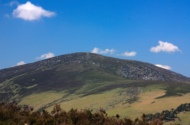
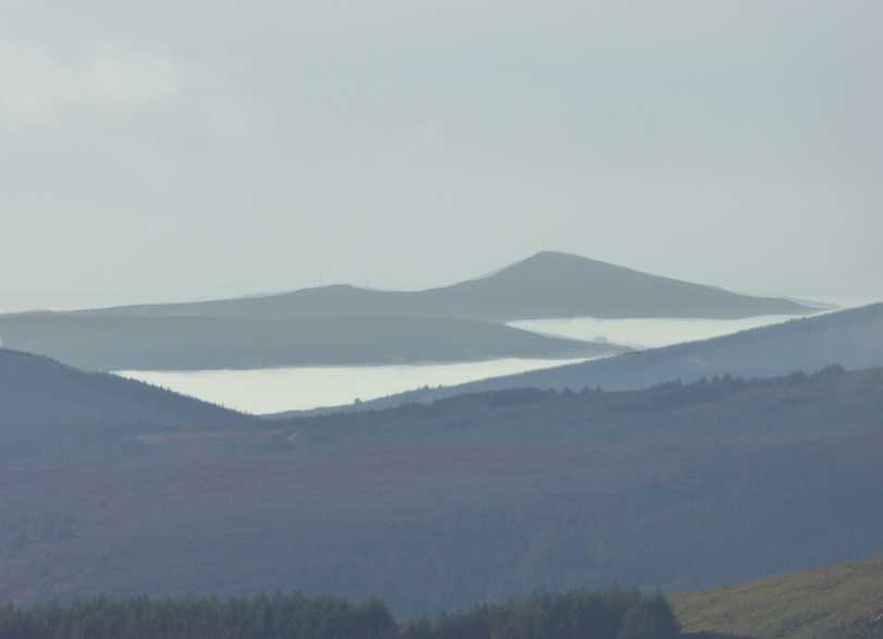
After a dry spell the track up the Luganure brook, which lies almost directly north of the SE top, makes for a very pleasant ascent of this mountain and offers lovely views of Glendasan on a clear day.

I started early from Glendalough, heading west along the St Kevin's Way track until I reached the ruins of mines close to the car park, around D (T097 982). When the Kevin's Way track turns slightly northward toward the road, you can follow a less defined track leading west initially, uphill, before turning south as it meanders around a number of spoil heaps and a few concealed adits. There is a bit of erosion along this track, and it may be a little wet in parts in winter. However, it is easily followed to the "summit" area.

I came across a herd of goats with shapely horns and heavy looking coats, as well as a pair of not so easily spooked deer.

From there, a return eastwards down the spine of Camaderry towards Glendalough is picturesque, and some plastic matting has helped consolidate the ground underfoot on this route.

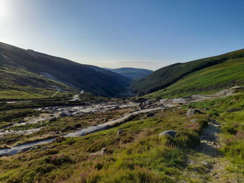
I have previously descended the track to the Upper Lake of Glendalough, which I located the top of near E (T10870 97098) but it is quite steep and could be slippery after rain. Not near as pleasant a descent as the main track down the east ridge. Linkback: mountainviews.ie/summit/1496/comment/23215/
Read Less
Read More

            MountainViews.ie picture about Camaderry East Top
Picture: Onzy proves yellow does suit him.
Only just is good enough
by jackill 10 Sep 2015
Camaderry South East Top is that rarest of things, a new addition to the Vandeleur Lynam List of Mountains,(over 600m in height with a prominence of 15 meters or more).

The survey of this hill was made on the 6th of September during a field trip which also involved the survey of Tomaneena and Fair Mountain by MountainViews and our British counterparts The Database of British and Irish Hills. We were fortunate on the day to be accompanied by an observer from the OSI.

As it happens Camaderry South East Top made it by the skin of its teeth, 26mm!
However its probably worth going to Camaderry South East for the magnificent view over Glendalough and the Wicklow Mountains. Linkback: mountainviews.ie/summit/1496/comment/18308/
Read Less
Read More

            MountainViews.ie picture about Camaderry East Top
Picture: A crisp and clear Wicklow morning
Summit panorama
by Colin Murphy 27 Oct 2017
Camaderry SE is a fairly unremarkable summit, but it does have unimpeded views of much of south and west Wicklow. The image shows what I think is a distant Lowbawn. Linkback: mountainviews.ie/summit/1496/comment/19771/
Read Less
Read More
EDIT Point of Interest
text
Videos


Recent Contributions
x
Conditions and Info
Use of MountainViews is governed by conditions and a privacy policy.
Read general information about the site.
Opinions in material here are not necessarily endorsed by MountainViews.
Hillwalking is a risk sport. Information in comments, walks, shared GPS tracks or about starting places may not be accurate for example as regards safety or access permission. You are responsible for your safety and your permission to walk.
See the credits and list definitions.

OSi logo
OSNI/LPS logo
Open Street Map
(Various variations used.)
British summit data courtesy:
Database of British & Irish Hills