Donation Request 2024

DONATE
Members and Supporters, the MountainViews Committee requests your help to meet the costs of the website and of other activities such as insured events or publications.
You do not have to be logged in to donate.
Features
Nearby features appear when you click the map.
Declutter tracks on map.
Place Search
Video
X
Pub: by
Wicklow Area , W: Donard Subarea
Feature count in area: 115, by county: Wicklow: 108, Kildare: 4, Wexford: 2, Carlow: 3, of which 1 is in both Wexford and Wicklow, of which 1 is in both Carlow and Wicklow, OSI/LPS Maps: 28B, 55, 56, 61, 62, AWW, EW-DM, EW-LG, EW-WE, EW-WS
Highest Place: Lugnaquilla 924.7m

Starting Places (205) in area Wicklow:
1916 Memorial Car Park, Aghavannagh Ow Bridge, Aghowle Wood, Altidore Wood Entrance, Annacurra National School, Annalecka Bridge, Asbawn Brook L8350, Aughrim National School, Ballard Road, Ballinabarny Gap, Ballinagappoge Bridge Layby, Ballinagappoge Mountain Hairpin, Ballinagore, Ballinahinch Wood, Ballinastoe MBT CP, Ballinastraw South, Ballineddan Upr Fork, Ballinfoyle Upr Cross, Ballycoog, Ballycreen Brook Bridge, Ballycumber, Ballycumber Bridge, Ballycumber Lane, Ballycumber Wicklow Way, Ballylerane, Ballylow Bridge, Ballylusk Quarry, Ballymanus Lane, Ballymoyle Shooting Lodge, Ballynultagh Gap, Ballynultagh Lane, Ballyreagh Wood, Ballyross Forest, Ballysmuttan Long Stone, Baravore, Barnbawn South, Barranisky North, Barranisky West, Bohilla Land Roundabout, Bohilla Lane Mid, Boranaraltry Bridge, Bray Harbour, Brewel West, Brittas Bay North CP, Buckroney Sand Dunes CP, Bus Terminus, Camera Hill Track Cross, Castletimon Wood North, Clara Vale, Clone House Road, Clonegal, Cloon Wood Cp, Coate Bridge, Coolballintaggart Ledge, Coolbawn House Lane, Cransillagh Brook , Crone Wood CP, Crossbridge, Crossoona Rath, Cummer Wood South, Curtlestown Wood CP, Deputy's Pass CP, Derralossary Church, Derry River Bridge, Devil's Glen CP, Devil's Glen Wood, Djouce Wood Calary, Djouce Wood Lake, Djouce Wood Long Hill, Donard, Donnelly's Lane Car Sales, Drumgoff Forest, Dunranhill North, Dunranhill SE, Dunranhill South, Dwyer McAllister Cottage CP, Enniskerry, Fentons Pub, Fitzsimons Park GAA, unuseableFlemings Footbridge Glen Rd, Gap Pub, Gap Road, Glen Beach CP, Glen of the Downs CP, Glenbride Lane, Glenbride Lodge, Glencree Reconciliation, Glendalough, Glenealy GAA, Glenmacnass Tonelagee CP, Glenmalure Hostel, Glenmalure Lodge, Glenmalure Waterfall, Glenview Hotel, Gowle House, Great Sugar Loaf CP, Grove Bar, Heffernans Well Wood, Hill View, Hollywood Glen, JB Malone CP, Johnnie Fox Pub, Keadeen NE trail, Keadeen Trailhead, Kevins Way Footbridge, Kilbride Army Camp Entrance, Kilcandra South, Kilcommon View, Killalongford Wood, Kilmacrea Cross Roads, Kilranelagh House Gate, Kilruddery Car Park, Kilruddery Cottages, Kings River, Kippure Bridge, Kippure Estate, Kippure Transmitter Gate, Knickeen Cross, Knocknaboley Lane Leeraghs Bog, Knocknaboley Lane Stone Cottage, Knockrath Little, Knockree west, Kyle Loop North, Lackan Wood S, Lake Dr Fraughan Brook, Lake Drive, Lake Park Cross, Lake View Pub, Laragh Free Car Park, Laragh NSch, Lead Mines CP, Liffey Bridge, Liffey Head Bridge, Lough Bray Lower, Lough Bray Upper, Lough Tay North Viewing Point, Lough Tay Wicklow Way CP, Luglass Lane L97561, Lugnagun Track, Macreddin Village, Mangans Lane, Military Road Carrigshouk Hill, Military Road Inchavore River Nth, Military Road Inchavore River Sth, Military Road NW Lough Tay, Military Road Ballyboy Bridge, Military Road Cloghoge Brook, Military Road Croaghanmoira, Military Road Fananierin, Military Road LaraghWicklow Way, Military Road Slieve Maan, Monspolien Bridge, Moortown House, Mountain Rescue HQ, Muskeagh Little Wood, Nahanagan Lough NE, Novara Avenue, Bray, Oiltiagh Brook Knickeen, Old Bridge Cross, Old Bridge Scouts , Old Wicklow Way entrance, Paddock Hill SE, Pier Gates CP, Powerscourt Waterfall CP, Putland Road, Quintagh East, Raheen Park CP, Raheenleagh East, Railway Walk CP, Rathdrum Railway Station, Rednagh Wood, Rocky Valley, Roundwood, Sally Gap, Sally Gap N, Seefin Trailhead, Seskin SE, Shankill Tributary Bridge, Shay Elliott, Sheepshanks Bridge, Shillelagh, Slievecorragh Track, Slievefoore South, Sraghoe Brook, St John's Church, St Kevins Chair, St Kevins Church, St Kevins Way R756, Stone Circle Bridge, Stookeen South, Stranahely Wood, Stranakelly Cross Roads, Tallyho, Templeboden, Tithewer, Tomcoyle L, Tomriland Wood, Toor Brook, Trooperstown Hill Access, Turlough Hill CP, Upper Lake CP, Vallymount GAA CP, Vartry Reservoir Upper, Zellers Pub

Summits & other features in area Wicklow:
Cen: Glendalough North: Brockagh Mountain 556.9m, Brockagh Mountain NW Top 549.5m, Brockagh Mountain SE Top 471.7m, Camaderry East Top 677.3m, Camaderry Mountain 698.6m, Conavalla 734m, Tomaneena 682.4m
Cen: Glendalough South: Carriglineen Mountain 456.6m, Cullentragh Mountain 510m, Derrybawn Mountain 476.1m, Kirikee Mountain 474.5m, Lugduff 653.2m, Lugduff SE Top 638m, Mullacor 660.7m, Trooperstown Hill 430m
N Cen: Tonelagee: Carrignagunneen 561m, Fair Mountain 571.2m, Stoney Top 713.7m, Tonelagee 815.8m, Tonelagee E Top 668m, Tonelagee South-East Top 545.8m
NE: Bray & Kilmacanogue: Bray Head Hill 238.9m, Carrigoona Commons East 242m, Downs Hill 372.9m, Great Sugar Loaf 501.2m, Little Sugar Loaf 342.4m
NE: Djouce: Djouce 725.5m, Knockree 342.1m, Maulin 570m, Tonduff 642m, Tonduff East Top 593m, War Hill 684.8m, White Hill 631.1m
NE: Fancy: Ballinafunshoge 480m, Kanturk 527.4m, Knocknacloghoge 532.4m, Luggala 593.3m, Robber's Pass Hill 508.9m, Scarr 640m, Scarr North-West Top 559.8m, Sleamaine 430m
NE: Vartry: Ballinacorbeg 336m, Ballycurry 301m, Dunranhill 342m, Mount Kennedy 365.9m
NW: Blessington: Carrigleitrim 408m, Lugnagun 446.2m, Slieveroe 332m, Sorrel Hill 599.5m
NW: Mullaghcleevaun: Black Hill 602.2m, Carrigshouk 572.5m, Carrigvore 682.4m, Duff Hill 720.8m, Gravale 719m, Moanbane 703m, Mullaghcleevaun 846.7m, Mullaghcleevaun East Top 796m, Silsean 698m
S: Aughrim Hills: Cushbawn 400m, Killeagh 249m, Moneyteige North 427m, Preban Hill 389m
S: Croaghanmoira: Ballinacor Mountain 529.3m, Ballycurragh Hill 536m, Ballyteige 447m, Carrickashane Mountain 508m, Croaghanmoira 662.3m, Croaghanmoira North Top 579.5m, Fananierin 426m, Slieve Maan 547.8m, Slieve Maan North Top 546.1m
S: Croghan Kinsella: Annagh Hill 454m, Croghan Kinsella 606m, Croghan Kinsella East Top 562.1m, Slievefoore 414m
S: Shillelagh Hills: Lakeen 357m, Monaughrim 206m, Seskin 344m, Stookeen 420m
S: Tinahely Hills: Ballycumber Hill 429.7m, Eagle Hill 296m, Muskeagh Hill 398.2m
SE: Wicklow South East: Ballinastraw 284m, Ballyguile Hill 188m, Barranisky 280m, Carrick Mountain 381m, Collon Hill 238m, Kilnamanagh Hill 217m, Westaston Hill 270m
W: Baltinglass: Ballyhook Hill 288m, Baltinglass Hill 382m, Carrig Mountain 571m, Carrigeen Hill 298m, Cloghnagaune 385m, Corballis Hill 258m, Keadeen Mountain 653m, Spinans Hill 409m, Spinans Hill SE Top 400m, Tinoran Hill 312m
W: Cen Lugnaquilla: Ballineddan Mountain 652.3m, Benleagh 689m, Camenabologue 758m, Camenabologue SE Top 663m, Cloghernagh 800m, Corrigasleggaun 794.6m, Lugnaquilla 924.7m, Slievemaan 759.7m
W: Donard: Brewel Hill 222m, Church Mountain 544m, Corriebracks 531m, Lobawn 636m, Slievecorragh 418m, Sugarloaf 552m, Table Mountain 701.7m, Table Mountain West Top 563m

Note: this list of places may include island features such as summits, but not islands as such.
Rating graphic.
Sugarloaf, 552m Mountain
Place Rating ..
, Black Mountain, Wicklow County in Leinster province, in no lists, Sugarloaf is the 418th highest place in Ireland.
Grid Reference S96825 96542, OS 1:50k mapsheet 56
Place visited by: 170 members, recently by: Magic, NualaB, Shaina, muddypaws, Kaszmirek78, Dee68, agakilbride, jimmytherabbit, MariaT, konrad, markv, Haulie, lauracardiff, Aongus, MickM45
I visited this place: NO (You need to be a logged-in member for this.)
Longitude: -6.558205, Latitude: 53.01114, Easting: 296825, Northing: 196542, Prominence: 14m,  Isolation: 1.7km
ITM: 696753 696576
Bedrock type: Dark slate-schist, quartzite & coticule, (Butter Mountain Formation)

  Short or GPS IDs, 6 char: Sgr552, 10 char: Sugarloaf

Linkback: https://mountainviews.ie/summit/1441/
Gallery for Sugarloaf and surrounds
No summary yet for this place .
Member Comments for Sugarloaf
Comment create / edit display placeholder

            MountainViews.ie picture about Sugarloaf
Picture: Sugarloaf, south Wicklow on the skyline left, taken from the South
Wicklow southerly one.
by simon3 21 Jun 2015
Wicklow has two Sugarloafs. This is the more southerly one just west of Lugnaquilla. The photo shows what it is like from the south (summit to the left). It certainly doesn't have the characteristic pointy sugarloaf look from this angle. Linkback: mountainviews.ie/summit/1441/comment/18149/
Read Less
Read More

I think you want the other one
by No1Grumbler 31 May 2021
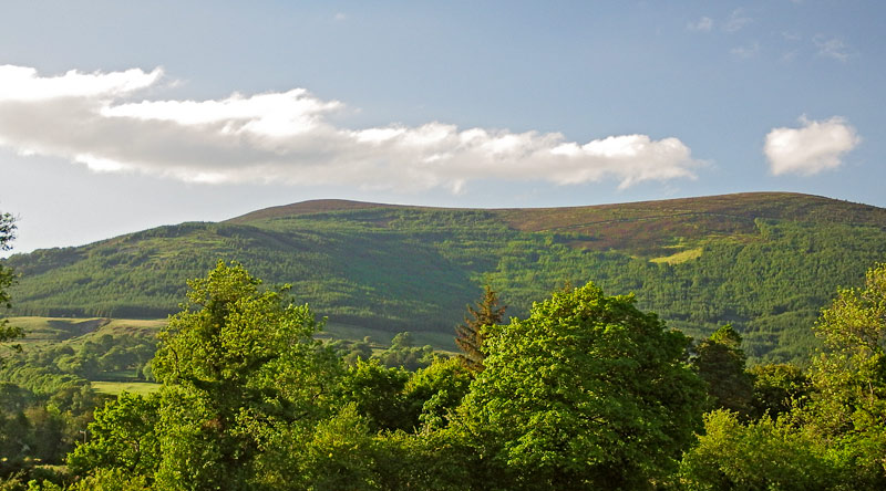
The Sugarloaf-Lobawn circuit is usually one of my walks reserved for a short winter day. However, the post-Covid return saw an unusallly sensible group of Grumblers decide on gentle walks as we return to hill fitness. This Sugarloaf seemed like a good idea. The usually quiet forestry entrance (
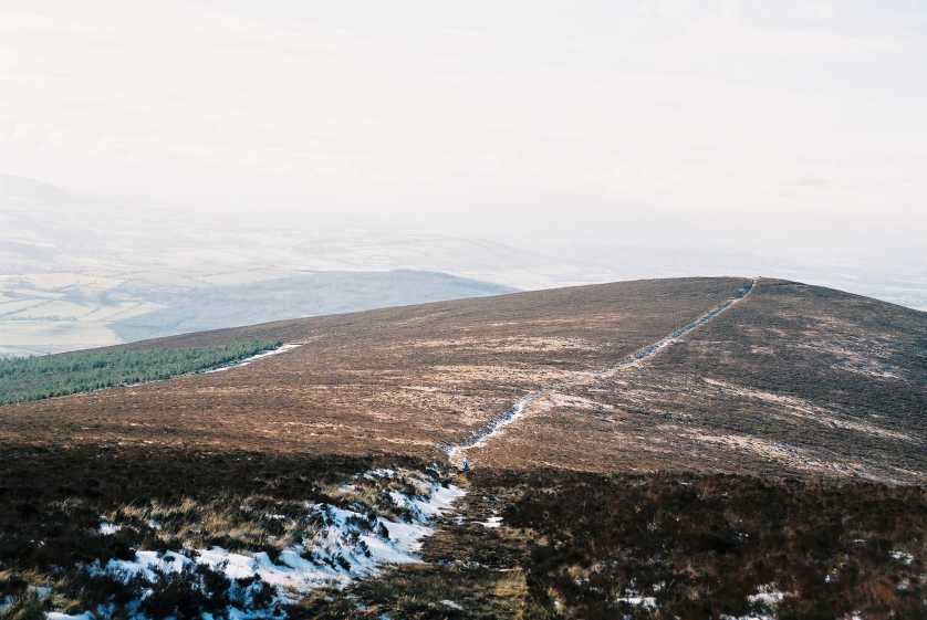
A (S95662 95723)) was already full of haphazardly parked cars as we pulled on boots etc. A couple in a Range Rover pulled up looking puzzled “Is this the Sugarloaf?”-“Yes,” “So where is the visitor centre?” It seems that Google Maps had brought them here instead of the Great Sugarloaf near Bray. Different Grumblers expressed a mixture of pity, schadenfreude and amusement as the couple sped off (hopefully not to the Sugarloaf hill in the Knockmealdowns). We have all been lost before (including a notorious incident climbing the wrong mountain in Skye’s Black Cuillin) but at least we’d been close. However, as we set off on a repeat of route 3860 up the Forestry, turning right at the “big stone”, we met another group descending, after realising they too were on the wrong mountain. In all we were to meet four different parties navigating on phones with Google maps and who thought they were near Bray and wondering why the sea was so far away. We tried not to be outraged or preachy, after all we were young idiots ourselves, and the day was long and clear. At the end of the good track, we made our turn E then NE and began the unrelenting ascent. Voortrekker, who is a youth, skipped up the contours with customary agility- stopping occasionally out of politeness, the rest of us huffed and puffed on the hottest day of the year, regretting the toll taken by a year of lockdown.

From the summit, we walked E to Point C- the 635m top, and then decided that our initial route was too short for a summer’s day. We dropped NE over heathery ground to reach the higher forestry track, and after strolling pleasantly along this, headed N for lunch in Cavanagh’s gap. Our return was uneventful- the steady climb to Lobawn, then following the broad shoulder NW, before descending SW over heather then grass down to the Black Pits for a delightful tea break in glorious sunshine by the river. A short climb saw us take the forestry track that skirts the lower N slopes of Sugarloaf, with views of the trophy houses across the glen, until by a commodious vicus of recirculation, we were back at the “Big Stone” and a short hop to the cars. As Voortrekker said, “there’s probably some poor fool driving to South Africa now to climb the wrong Table Mt.” Linkback: mountainviews.ie/summit/1441/comment/23162/
Read Less
Read More

            MountainViews.ie picture about Sugarloaf
Picture: Sugarloaf summit and path.
Blast from the past.
by paddyhillsbagger 5 Aug 2015
Climbed this hill with a friend back in 2007. We were staying in Donard Hse for a 50th so started from there following the road to B (S94749 97839) then track to cairn at C (S95937 98345) then to Lobawn. There is a track roughly Sth from this summit to D (S97634 96571) where there is one of those small Defence Force posts. A clear path W takes you to Sugarloaf top for fine views. We headed due Nth down the steep slope to pick up a forest path and thence road back to the pub in Donard. This was one of my first tops and I do remember being poorly attired with no compass which was a bit stupid in February with low cloud and snow. I bought both a compass and decent gear shortly after. Linkback: mountainviews.ie/summit/1441/comment/18229/
Read Less
Read More

            MountainViews.ie picture about Sugarloaf
Picture: Frog on Sugarloaf summit
Misty day, burned summit
by hibby 10 Sep 2021
Walked up Sugarloaf and Lobawn. Parked at the forest entrance and walked up along the forest fence. Evidence of recent fire in the area of the summit, with a blackened wasteland of burned heather to the west of the path and the summit cairn. I found a frog sitting in the unburned heather near the cairn and he obligingly posed for a photo.

Too misty for views today unfortunately. Linkback: mountainviews.ie/summit/1441/comment/23268/
Read Less
Read More
EDIT Point of Interest
text
Videos


Recent Contributions
x
Conditions and Info
Use of MountainViews is governed by conditions and a privacy policy.
Read general information about the site.
Opinions in material here are not necessarily endorsed by MountainViews.
Hillwalking is a risk sport. Information in comments, walks, shared GPS tracks or about starting places may not be accurate for example as regards safety or access permission. You are responsible for your safety and your permission to walk.
See the credits and list definitions.

OSi logo
OSNI/LPS logo
Open Street Map
(Various variations used.)
British summit data courtesy:
Database of British & Irish Hills